Yellow circle added and is at 10%.
SHOWER ACTIVITY ASSOCIATED WITH A TROPICAL WAVE LOCATED ABOUT 1000
MILES EAST OF THE LESSER ANTILLES REMAINS LIMITED. DEVELOPMENT...IF
ANY...WILL BE SLOW TO OCCUR DURING THE NEXT COUPLE OF DAYS WHILE
THE WAVE MOVES WESTWARD AT ABOUT 15 MPH AND APPROACHES THE LESSER
ANTILLES. AFTER THAT TIME...UPPER-LEVEL WINDS COULD INHIBIT FURTHER
DEVELOPMENT. THIS SYSTEM HAS A LOW CHANCE...NEAR 10 PERCENT...OF
BECOMING A TROPICAL CYCLONE DURING THE NEXT 48 HOURS...AND A LOW
CHANCE...20 PERCENT...OF BECOMING A TROPICAL CYCLONE DURING THE
NEXT 5 DAYS.
Tropical Wave in Central Atlantic (Is Invest 97L)
Moderator: S2k Moderators
Forum rules

The posts in this forum are NOT official forecasts and should not be used as such. They are just the opinion of the poster and may or may not be backed by sound meteorological data. They are NOT endorsed by any professional institution or STORM2K. For official information, please refer to products from the National Hurricane Center and National Weather Service.
-
cycloneye

- Admin

- Posts: 149486
- Age: 69
- Joined: Thu Oct 10, 2002 10:54 am
- Location: San Juan, Puerto Rico
Re: Tropical Wave in Central Atlantic (Pouch 25L) 10% / 20%
0 likes
Visit the Caribbean-Central America Weather Thread where you can find at first post web cams,radars
and observations from Caribbean basin members Click Here
and observations from Caribbean basin members Click Here
-
ouragans

- Category 2

- Posts: 501
- Age: 54
- Joined: Sun Jun 12, 2011 12:09 pm
- Location: Abymes, Guadeloupe F.W.I
- Contact:
Re: Tropical Wave in Central Atlantic (Pouch 25L) 10% / 20%
cycloneye wrote:Yellow circle added and is at 10%.
really?
This 5-days outlook must remain experimental, it has no meaning
EDIT: 4 updates to add the yellow area at 8:00!!!
0 likes
Personal forecast disclaimer
This post is a personal point of view, not an information. Please refer to official statements for life-threatening decisions.
David '79, Frederic '79, Hugo '89, Iris, Luis & Marilyn '95, Georges '98, Lenny '99, Dean '07, Irma '17, Maria '17, Fiona '22, Philippe '23, Tammy '23
16°13'33.3,"6N -61°36'39.5"W
-
Gustywind

- Category 5

- Posts: 12334
- Joined: Mon Sep 03, 2007 7:29 am
- Location: Baie-Mahault, GUADELOUPE
Re: Tropical Wave in Central Atlantic (Pouch 25L) 10% / 20%
ouragans wrote:cycloneye wrote:Yellow circle added and is at 10%.
really?after 5 days in their extended outlook, keeping people waiting, they could have been at least able to locate that yellow area. They updated the image 3 times, and no yellow circle!

This 5-days outlook must remain experimental, it has no meaning
EDIT: 4 updates to add the yellow area at 8:00!!!
That's a great observation Ouragans
0 likes
-
tolakram
- Admin
- Posts: 20185
- Age: 62
- Joined: Sun Aug 27, 2006 8:23 pm
- Location: Florence, KY (name is Mark)
Re: Tropical Wave in Central Atlantic (Pouch 25L) 10% / 20%
The euro still shows some organization in the vorticity plots and what I term a splotch of lower pressure. Since the euro has gone from showing absolutely nothing to something I can understand the need to pay attention. At 96 hours the euro stalls this vorticity, then shoots it almost due north and ends up in this position. Odd.

http://moe.met.fsu.edu/tcgengifs/
http://moe.met.fsu.edu/tcgengifs/
0 likes
M a r k
- - - - -
Join us in chat: Storm2K Chatroom Invite. Android and IOS apps also available.
The posts in this forum are NOT official forecasts and should not be used as such. Posts are NOT endorsed by any professional institution or STORM2K.org. For official information and forecasts, please refer to NHC and NWS products.
-
tolakram
- Admin
- Posts: 20185
- Age: 62
- Joined: Sun Aug 27, 2006 8:23 pm
- Location: Florence, KY (name is Mark)
Re: Tropical Wave in Central Atlantic (Pouch 25L) 10% / 20%
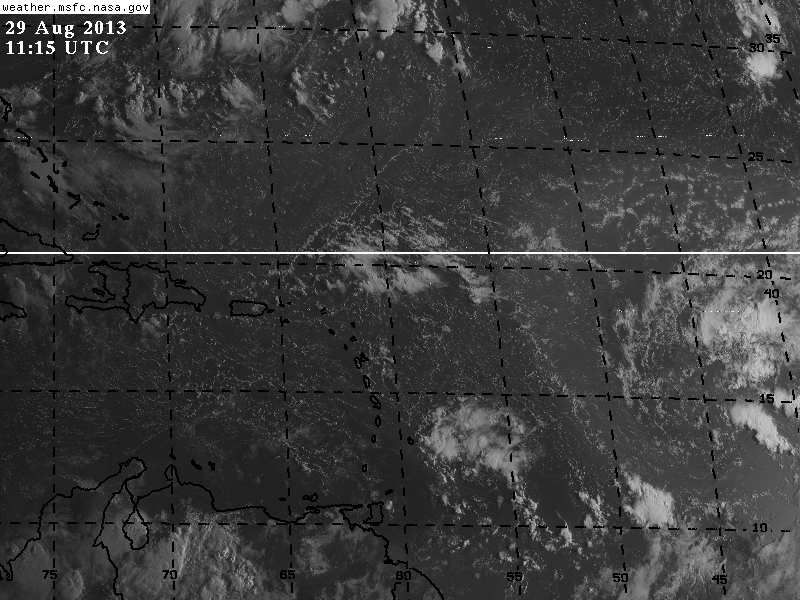
Live visible. Convection all north of the circulation.
http://wwwghcc.msfc.nasa.gov/cgi-bin/get-goes?satellite=GOES-E%20HURRICANE&lat=13&lon=-40&info=vis&zoom=2&width=1024&height=768&type=Animation&quality=92&palette=ir1.pal&numframes=5
http://wwwghcc.msfc.nasa.gov/cgi-bin/get-goes?satellite=GOES-E%20HURRICANE&lat=13&lon=-40&info=vis&zoom=2&width=1024&height=768&type=Animation&quality=92&palette=ir1.pal&numframes=5
0 likes
M a r k
- - - - -
Join us in chat: Storm2K Chatroom Invite. Android and IOS apps also available.
The posts in this forum are NOT official forecasts and should not be used as such. Posts are NOT endorsed by any professional institution or STORM2K.org. For official information and forecasts, please refer to NHC and NWS products.
- - - - -
Join us in chat: Storm2K Chatroom Invite. Android and IOS apps also available.
The posts in this forum are NOT official forecasts and should not be used as such. Posts are NOT endorsed by any professional institution or STORM2K.org. For official information and forecasts, please refer to NHC and NWS products.
-
CalmBeforeStorm
- Category 2
- Posts: 600
- Age: 72
- Joined: Tue Aug 10, 2004 7:55 pm
- Location: Stuart, Florida
http://tropic.ssec.wisc.edu/real-time/sal/splitE/movies/splitE5.html
This 5-day SAL loop shows that there was alot of SAL mixing in with the general circulation of 25L over the last few days. The latest pictures suggest that this SAL has mixed out which might allow for convection to form.
This 5-day SAL loop shows that there was alot of SAL mixing in with the general circulation of 25L over the last few days. The latest pictures suggest that this SAL has mixed out which might allow for convection to form.
Last edited by tolakram on Thu Aug 29, 2013 7:32 am, edited 1 time in total.
Reason: added URL tags
Reason: added URL tags
0 likes
This is not an official forecast and I am not a professional met though I did stay at a Holiday Inn Express last night.
-
tolakram
- Admin
- Posts: 20185
- Age: 62
- Joined: Sun Aug 27, 2006 8:23 pm
- Location: Florence, KY (name is Mark)
Re: Tropical Wave in Central Atlantic (Pouch 25L) 10% / 20%

0 likes
M a r k
- - - - -
Join us in chat: Storm2K Chatroom Invite. Android and IOS apps also available.
The posts in this forum are NOT official forecasts and should not be used as such. Posts are NOT endorsed by any professional institution or STORM2K.org. For official information and forecasts, please refer to NHC and NWS products.
- - - - -
Join us in chat: Storm2K Chatroom Invite. Android and IOS apps also available.
The posts in this forum are NOT official forecasts and should not be used as such. Posts are NOT endorsed by any professional institution or STORM2K.org. For official information and forecasts, please refer to NHC and NWS products.
-
hurricanes1234
- Category 5
- Posts: 2908
- Joined: Sat Jul 28, 2012 6:19 pm
- Location: Trinidad and Tobago
Re: Tropical Wave in Central Atlantic (Pouch 25L) 10% / 20%
As of now, I just don't see this developing. Nearly everything will inhibit development, the only thing favourable is warm water. Of course, there's the exceedingly dry air and Sahara dust everywhere, and the wind shear will soon increase, so it seems questionable to me how something could develop when the air is sinking and blowing in different directions. Does anyone else agree? Of course, this is just an ameteur opinion.
The posts in this forum are NOT official forecast and should not be used as such. They are just the opinion of the poster and may or may not be backed by sound meteorological data. They are NOT endorsed by any professional institution or storm2k.org. For official information, please refer to the NHC and NWS products.
The posts in this forum are NOT official forecast and should not be used as such. They are just the opinion of the poster and may or may not be backed by sound meteorological data. They are NOT endorsed by any professional institution or storm2k.org. For official information, please refer to the NHC and NWS products.
0 likes
PLEASE NOTE: With the exception of information from weather agencies that I may copy and paste here, my posts will NEVER be official, since I am NOT a meteorologist. They are solely my amateur opinion, and may or may not be accurate. Therefore, please DO NOT use them as official details, particularly when making important decisions. Thank you.

There is still some magic dust to the north and west of this TW as seen on the visible satellite this morning, it may not be the problem down the road but the GFS forecasts yet another ULL near Hispaniola/PR that shreds it apart as the TW approaches it.
The GFS has been doing a good job with these ULLs.
The GFS has been doing a good job with these ULLs.
0 likes


-
CalmBeforeStorm
- Category 2
- Posts: 600
- Age: 72
- Joined: Tue Aug 10, 2004 7:55 pm
- Location: Stuart, Florida
Re:
NDG wrote:On this visible satellite pix you can clearly see a ring of the magic dust possibly getting entrained into the circulation from the western quadrant.
http://i20.photobucket.com/albums/b245/ ... 44fd44.jpg
http://tropic.ssec.wisc.edu/real-time/salmain.php?&prod=splitE&time
Much less and getting less all the time as shown on the 5 day loop.
Last edited by wxman57 on Thu Aug 29, 2013 10:11 am, edited 2 times in total.
Reason: added URL tags
Reason: added URL tags
0 likes

Re:
gatorcane wrote:06Z FIM spins it up at 168 hours. Though it keeps pushing back development so not sure how believable this is
http://img823.imageshack.us/img823/1426/m6bc.png
looks like a strong open wave on the FIM... no west winds
0 likes
-
northjaxpro

- S2K Supporter

- Posts: 8900
- Joined: Mon Sep 27, 2010 11:21 am
- Location: Jacksonville, FL
Yeah, I just don't see this developing. Too much dry air entrained into the system. The same old story for 2013 continues for the tropical Atlantic basin, which is that is it as dead as a doorknob.
0 likes
NEVER, EVER SAY NEVER in the tropics and weather in general, and most importantly, with life itself!!
________________________________________________________________________________________
Fay 2008 Beryl 2012 Debby 2012 Colin 2016 Hermine 2016 Julia 2016 Matthew 2016 Irma 2017 Dorian 2019
________________________________________________________________________________________
Fay 2008 Beryl 2012 Debby 2012 Colin 2016 Hermine 2016 Julia 2016 Matthew 2016 Irma 2017 Dorian 2019
-
tolakram
- Admin
- Posts: 20185
- Age: 62
- Joined: Sun Aug 27, 2006 8:23 pm
- Location: Florence, KY (name is Mark)
Re: Tropical Wave in Central Atlantic (Pouch 25L) 10% / 20%
I don't know if this is a usable metric or not, but looking at the 500-300mb relative humidity it sure seems like these values should be higher in the tropics.
from the 6Z GFS
http://moe.met.fsu.edu/cgi-bin/gfstc2.cgi?time=2013082906&field=500-300mb+Mean+RH&hour=Animation
from the 6Z GFS
http://moe.met.fsu.edu/cgi-bin/gfstc2.cgi?time=2013082906&field=500-300mb+Mean+RH&hour=Animation
0 likes
M a r k
- - - - -
Join us in chat: Storm2K Chatroom Invite. Android and IOS apps also available.
The posts in this forum are NOT official forecasts and should not be used as such. Posts are NOT endorsed by any professional institution or STORM2K.org. For official information and forecasts, please refer to NHC and NWS products.
- - - - -
Join us in chat: Storm2K Chatroom Invite. Android and IOS apps also available.
The posts in this forum are NOT official forecasts and should not be used as such. Posts are NOT endorsed by any professional institution or STORM2K.org. For official information and forecasts, please refer to NHC and NWS products.
-
Hurricaneman

- Category 5
- Posts: 7404
- Age: 45
- Joined: Tue Aug 31, 2004 3:24 pm
- Location: central florida
This system looks a little better, but still limited convection
The posts in this forum are NOT official forecast and should not be used as such. They are just the opinion of the poster and may or may not be backed by sound meteorological data. They are NOT endorsed by any professional institution or storm2k.org. For official information, please refer to the NHC and NWS products
The posts in this forum are NOT official forecast and should not be used as such. They are just the opinion of the poster and may or may not be backed by sound meteorological data. They are NOT endorsed by any professional institution or storm2k.org. For official information, please refer to the NHC and NWS products
0 likes
-
HurricaneDREW92
- Category 1

- Posts: 320
- Age: 27
- Joined: Sun Jul 28, 2013 11:56 am
- Location: Boston, MA
Re:
Hurricaneman wrote:This system looks a little better, but still limited convection
The posts in this forum are NOT official forecast and should not be used as such. They are just the opinion of the poster and may or may not be backed by sound meteorological data. They are NOT endorsed by any professional institution or storm2k.org. For official information, please refer to the NHC and NWS products
Think they should bump up the 5 day development chances to 30% at 2pm.
0 likes
This post is NOT AN OFFICIAL FORECAST and should not be used as such. It is just the opinion of the poster and may or may not be backed by sound meteorological data. It is NOT endorsed by any professional institution including storm2k.org. For Official Information please refer to the NHC and NWS products.
-THE ABOVE IS THE OPINION OF DREW ONLY
-THE ABOVE IS THE OPINION OF DREW ONLY
-
Hurricaneman
- Category 5
- Posts: 7404
- Age: 45
- Joined: Tue Aug 31, 2004 3:24 pm
- Location: central florida
Re: Re:
HurricaneDREW92 wrote:Hurricaneman wrote:This system looks a little better, but still limited convection
The posts in this forum are NOT official forecast and should not be used as such. They are just the opinion of the poster and may or may not be backed by sound meteorological data. They are NOT endorsed by any professional institution or storm2k.org. For official information, please refer to the NHC and NWS products
Think they should bump up the 5 day development chances to 30% at 2pm.
I completely disagree until the GFS comes onboard with the other models that it should stay at 20% in 5 days
The posts in this forum are NOT official forecast and should not be used as such. They are just the opinion of the poster and may or may not be backed by sound meteorological data. They are NOT endorsed by any professional institution or storm2k.org. For official information, please refer to the NHC and NWS products
0 likes
Who is online
Users browsing this forum: AnnularCane, CycloneSakura and 306 guests