
ATL: GABRIELLE - Remnants - Discussion
Moderator: S2k Moderators
Okay, did this thing move at all over the last 6 hours? I swear it just sat there and absorbed the other wave and fired up convection near the center all night long.
0 likes
The posts in this forum are NOT official forecast and should not be used as such. They are just the opinion of the poster and may or may not be backed by sound meteorological data. They are NOT endorsed by any professional institution or storm2k.org. For official information, please refer to the NHC and NWS products.
Is it dealing with some sheer right now? Cause it certainly looks like it. The overall appearance looks pretty ragged IMO. Can find any COC. W
0 likes
The posts in this forum are NOT official forecast and should not be used as such. They are just the opinion of the poster and may or may not be backed by sound meteorological data. They are NOT endorsed by any professional institution or storm2k.org. For official information, please refer to the NHC and NWS products.


Re: ATL: GABRIELLE - Tropical Storm - Discussion
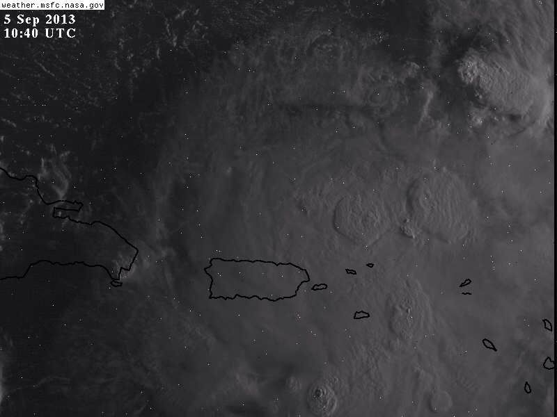
1045Z VIS/IR (Day/Night)

Last edited by TheBurn on Thu Sep 05, 2013 6:34 am, edited 1 time in total.
0 likes

Re: ATL: GABRIELLE - Tropical Storm - Discussion
The center appears to be on a 020 heading...
0 likes
Re: ATL: GABRIELLE - Tropical Storm - Discussion
I took a tour on wundermap and I cannot find any evidence of a tight surface COC, IMO the the recon will find nothing but a broad area of low pressure, a new LLC might form layer today closer to the MLC and deep convection east of P.R.
0 likes
-
ninel conde
Re:
HurriGuy wrote:Is it dealing with some sheer right now? Cause it certainly looks like it. The overall appearance looks pretty ragged IMO. Can find any COC. W
NHC did say it might dissipate. its isnt aligned at all and may be a strong wave. naming it may have been premature.
0 likes
-
ninel conde
Re: ATL: GABRIELLE - Tropical Storm - Discussion
NDG wrote:I took a tour on wundermap and I cannot find any evidence of a tight surface COC, IMO the the recon will find nothing but a broad area of low pressure, a new LLC might form layer today closer to the MLC and deep convection east of P.R.
maybe, but i think the convection is going to dry up quite a bit today which will weaken any circ even more. something interesting to watch is the moisture is streaming into the upper low se of bermuda. maybe the ull will begin to take on tropical characteristics before it heads on out.
Last edited by ninel conde on Thu Sep 05, 2013 6:42 am, edited 1 time in total.
0 likes
-
jlauderdal
- S2K Supporter

- Posts: 7240
- Joined: Wed May 19, 2004 5:46 am
- Location: NE Fort Lauderdale
- Contact:
Re: Re:
ninel conde wrote:HurriGuy wrote:Is it dealing with some sheer right now? Cause it certainly looks like it. The overall appearance looks pretty ragged IMO. Can find any COC. W
NHC did say it might dissipate. its isnt aligned at all and may be a strong wave. naming it may have been premature.
they name systems based on the data at the present, they don't consider the future when deciding if it should be named or not..we have seen storms get named and then die in less than a day..remember nhc is operating on science and facts not conjecture like we get to do here..
0 likes
looks like 2013 season is still shaping up to be pitiful. Gab. looks raggedy.
0 likes
The posts in this forum are NOT official forecast and should not be used as such. They are just the opinion of the poster and may or may not be backed by sound meteorological data. They are NOT endorsed by any professional institution or storm2k.org. For official information, please refer to the NHC and NWS products.
-
jlauderdal
- S2K Supporter
- Posts: 7240
- Joined: Wed May 19, 2004 5:46 am
- Location: NE Fort Lauderdale
- Contact:
Re:
HurriGuy wrote:looks like 2013 season is still shaping up to be pitiful. Gab. looks raggedy.
almost two full months left, October is statistically most active for florida...wouldn't be a "pitiful" for season for someone that gets hit..wilma rolled through here end of october
0 likes
-
cycloneye

- Admin

- Posts: 149505
- Age: 69
- Joined: Thu Oct 10, 2002 10:54 am
- Location: San Juan, Puerto Rico
Re: ATL: GABRIELLE - Tropical Storm - Discussion
SUMMARY OF 800 AM AST...1200 UTC...INFORMATION
----------------------------------------------
LOCATION...17.7N 67.4W
ABOUT 65 MI...105 KM WSW OF PONCE PUERTO RICO
ABOUT 85 MI...135 KM SE OF PUNTA CANA DOMINICAN REPUBLIC
MAXIMUM SUSTAINED WINDS...40 MPH...65 KM/H
PRESENT MOVEMENT...NW OR 320 DEGREES AT 8 MPH...13 KM/H
MINIMUM CENTRAL PRESSURE...1008 MB...29.77 INCHES
0 likes
Visit the Caribbean-Central America Weather Thread where you can find at first post web cams,radars
and observations from Caribbean basin members Click Here
and observations from Caribbean basin members Click Here
-
tolakram
- Admin
- Posts: 20186
- Age: 62
- Joined: Sun Aug 27, 2006 8:23 pm
- Location: Florence, KY (name is Mark)
Re: ATL: GABRIELLE - Tropical Storm - Discussion
0 likes
M a r k
- - - - -
Join us in chat: Storm2K Chatroom Invite. Android and IOS apps also available.
The posts in this forum are NOT official forecasts and should not be used as such. Posts are NOT endorsed by any professional institution or STORM2K.org. For official information and forecasts, please refer to NHC and NWS products.
-
ninel conde
Re: Re:
jlauderdal wrote:HurriGuy wrote:looks like 2013 season is still shaping up to be pitiful. Gab. looks raggedy.
almost two full months left, October is statistically most active for florida...wouldn't be a "pitiful" for season for someone that gets hit..wilma rolled through here end of october
would have to see a ridge build over new england first. also, when the meat of the season is weak and dried up they often end early. back to gab, we may be seeing a dennis 1999 scenario play out. in that case all the moisture with dennis got stripped away by powerful shear and its low level swirl drifted around till it redevloped and backed into NC. 2 things to watch for. can gab maintain a swirl, if it even has one, and can it drift around long enough for a high to build and lock in north of it.
0 likes
Re: ATL: GABRIELLE - Tropical Storm - Discussion
http://radar.weather.gov/ridge/radar.php?rid=JUA&product=N0R&overlay=11101111&loop=yes
bye bye. Puerto Rico looks to be doing fine now.
bye bye. Puerto Rico looks to be doing fine now.
0 likes
The posts in this forum are NOT official forecast and should not be used as such. They are just the opinion of the poster and may or may not be backed by sound meteorological data. They are NOT endorsed by any professional institution or storm2k.org. For official information, please refer to the NHC and NWS products.
-
tolakram
- Admin
- Posts: 20186
- Age: 62
- Joined: Sun Aug 27, 2006 8:23 pm
- Location: Florence, KY (name is Mark)
Re: ATL: GABRIELLE - Tropical Storm - Discussion
That darn Euro model and it's tendency to be correct. 
This is how last nights Euro run initialized the vorticity. I thought it was crazy.

It sure looks like the center is trying to reform NE of PR.
Personal Forecast Disclaimer:
The posts in this forum are NOT official forecast and should not be used as such. They are just the opinion of the poster and may or may not be backed by sound meteorological data. They are NOT endorsed by any professional institution or storm2k.org. For official information, please refer to the NHC and NWS products.
This is how last nights Euro run initialized the vorticity. I thought it was crazy.
It sure looks like the center is trying to reform NE of PR.
Personal Forecast Disclaimer:
The posts in this forum are NOT official forecast and should not be used as such. They are just the opinion of the poster and may or may not be backed by sound meteorological data. They are NOT endorsed by any professional institution or storm2k.org. For official information, please refer to the NHC and NWS products.
0 likes
M a r k
- - - - -
Join us in chat: Storm2K Chatroom Invite. Android and IOS apps also available.
The posts in this forum are NOT official forecasts and should not be used as such. Posts are NOT endorsed by any professional institution or STORM2K.org. For official information and forecasts, please refer to NHC and NWS products.
- - - - -
Join us in chat: Storm2K Chatroom Invite. Android and IOS apps also available.
The posts in this forum are NOT official forecasts and should not be used as such. Posts are NOT endorsed by any professional institution or STORM2K.org. For official information and forecasts, please refer to NHC and NWS products.
-
ninel conde
Re: ATL: GABRIELLE - Tropical Storm - Discussion
HurriGuy wrote:http://radar.weather.gov/ridge/radar.php?rid=JUA&product=N0R&overlay=11101111&loop=yes
bye bye. Puerto Rico looks to be doing fine now.
if there is a circ its very broad. while western PR looks rather dry it does appear that a persistent rain band has set up over eastern PR.
0 likes
Re: ATL: GABRIELLE - Tropical Storm - Discussion
http://radar.weather.gov/ridge/radar.php?product=NTP&rid=JUA&loop=yes
Biggest impact overnight was the west side of St. Croix with around 4 inches.
Biggest impact overnight was the west side of St. Croix with around 4 inches.
0 likes
The posts in this forum are NOT official forecast and should not be used as such. They are just the opinion of the poster and may or may not be backed by sound meteorological data. They are NOT endorsed by any professional institution or storm2k.org. For official information, please refer to the NHC and NWS products.
Who is online
Users browsing this forum: No registered users and 49 guests