ATL: INGRID - Remnants - Discussion

Moderator: S2k Moderators

Message
Author
MaineWeatherNut
Tropical Storm
Tropical Storm
Posts: 225
Joined: Sun Sep 01, 2013 5:06 pm

Re: ATL: INVEST 93L - Discussion - 60% - 80%

#301 Postby MaineWeatherNut » Thu Sep 12, 2013 11:26 am

panamatropicwatch wrote:93L is under some heavy shear right now http://tropic.ssec.wisc.edu/real-time/atlantic/winds/wg8shr.GIF that will keep it from ramping up for a little while.


How much of it is self induced shear though and how much of it is actually shear that would be affecting it?
0 likes   
The content of this post does NOT constitute official forecast and should not be used as such. They are the opinion of the poster and may or may not be backed by sound meteorological data. They are NOT endorsed by any professional institution or Storm2K. For official information, please refer to the local meteorological centers of respective areas.

Wx_Warrior
Category 5
Category 5
Posts: 2718
Joined: Thu Aug 03, 2006 3:58 pm
Location: Beaumont, TX

Re: ATL: INVEST 93L - Discussion - 60% - 80%

#302 Postby Wx_Warrior » Thu Sep 12, 2013 11:38 am

Some (wink wink) thought I was crazy when I posted a few days ago that the ridge would hold thru Sunday....Ridge looks to hold thru Tuesday then move east.
0 likes   

Stormcenter
S2K Supporter
S2K Supporter
Posts: 6684
Joined: Wed Sep 03, 2003 11:27 am
Location: Houston, TX

Re: ATL: INVEST 93L - Models

#303 Postby Stormcenter » Thu Sep 12, 2013 11:38 am

The NWS out of N.O.,LA. seems to think there is chance some of the moisture may head north.

AREA FORECAST DISCUSSION
NATIONAL WEATHER SERVICE NEW ORLEANS LA
412 AM CDT THU SEP 12 2013


MEANWHILE...A TROPICAL WAVE TRACKING ACROSS THE YUCATAN PENINSULA
THIS MORNING WILL EMERGE IN BAY OF CAMPECHE LATER TODAY. THE WAVE
WILL BE FAIRLY SLOW TO MOVE ACROSS THE BAY...POSSIBLY NOT REACHING
LAND AGAIN UNTIL EARLY NEXT WEEK. GLOBAL MODELS DO SUGGEST
DEVELOPMENT WITH THIS SYSTEM IS POSSIBLE AS CONDITIONS APPEAR TO BE
FAVORABLE FOR THIS TO OCCUR. THE GOOD NEWS IS THAT BY THEN...UPPER
TROUGH TO THE NORTHEAST WILL BE EJECTING AND A WEAK RIDGE WILL BE
BUILDING BACK IN OVER THE GULF COAST. THE GENERAL MODEL CONSENSUS IS
THAT THIS HIGH SHOULD KEEP THE TROPICAL FEATURE HEADED WEST INTO
MEXICO OR EXTREME SOUTH TEXAS BUT IT MAY STILL SEND ENOUGH MOISTURE
NORTH INTO THE CWA FOR SCATTERED SHOWERS AND THUNDERSTORMS TO
DEVELOP THIS WEEKEND INTO EARLY NEXT WEEK
wxman57 wrote:
djmikey wrote::?: Just curious. I know everyone is discussing "landfall" location, but what will the storm do AND go after landfall? Will she continue west? Will she turn northward? And can we expect ANY moisture from her in TX AFTER landfall? All I have read is her possible landfall location and nothing on where she will go after landfall. Many tropical systems create havoc of flooding rains days after they have made landfall. Just wondring if we can POSSIBLY expect a piece of her later down the road. Thanks!


It appears that the ridge will remain over Texas through early next week. That would keep all the moisture from this storm well south of SE TX.
0 likes   

User avatar
Portastorm
Storm2k Moderator
Storm2k Moderator
Posts: 9914
Age: 63
Joined: Fri Jul 11, 2003 9:16 am
Location: Round Rock, TX
Contact:

Re: ATL: INVEST 93L - Discussion - 60% - 80%

#304 Postby Portastorm » Thu Sep 12, 2013 11:40 am

:uarrow:

Well, the 6z GFS showed very generous rains covering much of the southern half of the state in the next 5-10 days.
0 likes   
Any forecasts under my name are to be taken with a grain of salt. Get your best forecasts from the National Weather Service and National Hurricane Center.

CrazyC83
Professional-Met
Professional-Met
Posts: 34002
Joined: Tue Mar 07, 2006 11:57 pm
Location: Deep South, for the first time!

#305 Postby CrazyC83 » Thu Sep 12, 2013 11:41 am

From what I can estimate, the environmental shear is about 15 kt, so not low, but not terribly hostile. The rest of it looks to be self-induced.
0 likes   

User avatar
ROCK
Category 5
Category 5
Posts: 9484
Age: 54
Joined: Tue Aug 17, 2004 7:30 am
Location: Kemah, Texas

Re: ATL: INVEST 93L - Discussion - 60% - 80%

#306 Postby ROCK » Thu Sep 12, 2013 11:48 am

the GFS has the ridge retreating at 117hr and gone by 129hr.....just saying... :D
0 likes   

JGrin87
Tropical Storm
Tropical Storm
Posts: 121
Joined: Thu Feb 11, 2010 2:06 am
Location: Houston, Texas

Re: ATL: INVEST 93L - Discussion - 60% - 80%

#307 Postby JGrin87 » Thu Sep 12, 2013 11:52 am

Alyono wrote:
tailgater wrote:
GCANE wrote:Here we go, hot tower firing up. IMHO all signs RI underway.


http://www.nrlmry.navy.mil/htdocs_dyn_a ... xico.0.jpg


Yes if thier is a LLC under that Vigous MLC then it will be deepening quickly, but I don't see any clear indications at the surface yet.
Looks pretty good on radar. :eek:


surface obs indicate that is where the surface center is


Please expand...
0 likes   

Time_Zone
Category 1
Category 1
Posts: 251
Joined: Sat May 08, 2010 4:15 am

Re: ATL: INVEST 93L - Discussion - 60% - 80%

#308 Postby Time_Zone » Thu Sep 12, 2013 12:02 pm

panamatropicwatch wrote:93L is under some heavy shear right now http://tropic.ssec.wisc.edu/real-time/atlantic/winds/wg8shr.GIF that will keep it from ramping up for a little while.


Most of that is self-induced....wind shear is quite low 10-15 Knots as far as I can tell.
0 likes   

Time_Zone
Category 1
Category 1
Posts: 251
Joined: Sat May 08, 2010 4:15 am

Re:

#309 Postby Time_Zone » Thu Sep 12, 2013 12:09 pm

CrazyC83 wrote:From what I can estimate, the environmental shear is about 15 kt, so not low, but not terribly hostile. The rest of it looks to be self-induced.


It has very light shear.....it shouldn't have any issues intensifying as far as I can tell it looks to be doing just that right now.
0 likes   

HurriGuy
S2K Supporter
S2K Supporter
Posts: 734
Joined: Thu Aug 15, 2013 8:43 pm
Location: Prairieville, LA

Re: ATL: INVEST 93L - Discussion - 60% - 80%

#310 Postby HurriGuy » Thu Sep 12, 2013 12:26 pm

http://www.tropicaltidbits.com/analysis/models/gem/2013091212/gem_apcpn_watl.html

Looks like CMC will be wrapping all this moisture WAY to the east.
0 likes   
The posts in this forum are NOT official forecast and should not be used as such. They are just the opinion of the poster and may or may not be backed by sound meteorological data. They are NOT endorsed by any professional institution or storm2k.org. For official information, please refer to the NHC and NWS products.

User avatar
cycloneye
Admin
Admin
Posts: 145303
Age: 68
Joined: Thu Oct 10, 2002 10:54 am
Location: San Juan, Puerto Rico

Re: ATL: INVEST 93L - Discussion - 60% - 80%

#311 Postby cycloneye » Thu Sep 12, 2013 12:31 pm

2 PM TWO=TD could be forming-80%-90%

SATELLITE AND SURFACE OBSERVATIONS INDICATE THAT A TROPICAL
DEPRESSION COULD BE FORMING IN THE SOUTH-CENTRAL BAY OF
CAMPECHE...AND IF THIS TREND CONTINUES...ADVISORIES WILL BE
INITIATED LATER TODAY OR TONIGHT
. AN AIR FORCE PLANE IS SCHEDULED
TO INVESTIGATE THIS DISTURBANCE LATER TODAY. EVEN IF A TROPICAL
CYCLONE DOES NOT FORM TODAY...ENVIRONMENTAL CONDITIONS ARE FORECAST
TO REMAIN VERY FAVORABLE FOR DEVELOPMENT...AND THIS LOW HAS A HIGH
CHANCE...80 PERCENT...OF BECOMING A TROPICAL CYCLONE DURING THE
NEXT 48 HOURS...AND A HIGH CHANCE...90 PERCENT...OF BECOMING A
TROPICAL CYCLONE DURING THE NEXT 5 DAYS. THIS DISTURBANCE IS
FORECAST TO MOVE VERY SLOWLY ACROSS THE SOUTHERN GULF OF MEXICO
PRODUCING LOCALLY HEAVY RAINS OVER A LARGE PART OF EASTERN MEXICO
DURING THE NEXT SEVERAL DAYS. THESE RAINS COULD CAUSE
LIFE-THREATENING FLASH FLOODS AND MUD SLIDES.
0 likes   
Visit the Caribbean-Central America Weather Thread where you can find at first post web cams,radars
and observations from Caribbean basin members Click Here

User avatar
cycloneye
Admin
Admin
Posts: 145303
Age: 68
Joined: Thu Oct 10, 2002 10:54 am
Location: San Juan, Puerto Rico

Re: ATL: INVEST 93L - Discussion - 80% - 90%

#312 Postby cycloneye » Thu Sep 12, 2013 12:44 pm

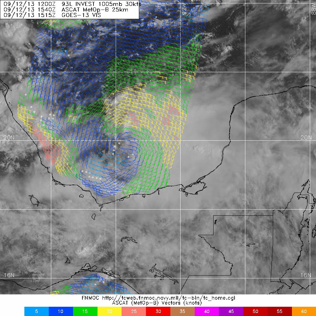
ASCAT pass caught closed low.

Image
0 likes   
Visit the Caribbean-Central America Weather Thread where you can find at first post web cams,radars
and observations from Caribbean basin members Click Here

Alyono
Professional-Met
Professional-Met
Posts: 6961
Joined: Fri Apr 26, 2013 3:52 pm
Location: Texas Coast

#313 Postby Alyono » Thu Sep 12, 2013 1:00 pm

that IS a TD
0 likes   

jeff
Professional-Met
Professional-Met
Posts: 831
Joined: Sun Sep 12, 2004 6:14 pm
Location: Houston, TX
Contact:

Re: ATL: INVEST 93L - Discussion - 80% - 90%

#314 Postby jeff » Thu Sep 12, 2013 1:10 pm

Indeed...this is a TD
0 likes   

User avatar
GCANE
S2K Supporter
S2K Supporter
Posts: 11496
Joined: Mon Oct 22, 2007 8:03 am

Re: ATL: INVEST 93L - Discussion - 80% - 90%

#315 Postby GCANE » Thu Sep 12, 2013 1:12 pm

Given the rotation on vis and the SCAT, no doubt a TD.

http://www.ssd.noaa.gov/PS/TROP/floaters/93L/imagery/vis-animated.gif
0 likes   

User avatar
Tireman4
S2K Supporter
S2K Supporter
Posts: 5853
Age: 59
Joined: Fri Jun 30, 2006 1:08 pm
Location: Humble, Texas
Contact:

#316 Postby Tireman4 » Thu Sep 12, 2013 1:23 pm

Well two mets have chimed in...Wxman 57? Jonathan?
0 likes   

User avatar
Rgv20
S2K Supporter
S2K Supporter
Posts: 2466
Age: 38
Joined: Wed Jan 05, 2011 5:42 pm
Location: Edinburg/McAllen Tx

#317 Postby Rgv20 » Thu Sep 12, 2013 1:29 pm

Agree most definitely a TD now..


Today's forecast discussion out of the WPC (Weather Prediction Center)

THE MOST
SIGNIFICANT SENSIBLE WEATHER THREAT IN THIS REGARD WILL BE OVER
SOUTH TEXAS ON THE OTHER SIDE OF THE SUBTROPICAL RIDGE AXIS. A
TROPICAL SYSTEM--INVEST AL93--OVER THE SOUTHERN BAY OF CAMPECHE IS
EXPECTED TO SLOWLY ROTATE WEST-NORTHWESTWARD INTO THE EAST COAST
OF MEXICO OVER THE NEXT 5 DAYS, SPREADING PRODIGIOUS RAINFALL INTO
THE TERRAIN CLOSE TO THE COASTLINE. THE FOCUSED EAST-SOUTHEAST
FLOW TO THE NORTH OF THE SYSTEM IS EXPECTED TO ENHANCE RAINFALL
ALONG THE SOUTH TEXAS COAST, WITH SOME GUIDANCE SHOWING MORE THAN
10 INCHES IN A COUPLE LOCATIONS.
THIS FORECAST WILL BE REFINED IN
THE COMING DAYS ONCE THE TROPICAL FEATURE IS RESOLVED.


CISCO
0 likes   
The following post is NOT an official forecast and should not be used as such. It is just the opinion of the poster and may or may not be backed by sound meteorological data. It is NOT endorsed by any professional institution including storm2k.org For Official Information please refer to the NHC and NWS products.

JonathanBelles
Professional-Met
Professional-Met
Posts: 11430
Age: 35
Joined: Sat Dec 24, 2005 9:00 pm
Location: School: Florida State University (Tallahassee, FL) Home: St. Petersburg, Florida
Contact:

#318 Postby JonathanBelles » Thu Sep 12, 2013 1:30 pm

I can't say anything more than others have said, but the scat pass clearly shows that a closed circulation has formed. The only hesitation I have is that thunderstorm activity has decreased since that pass. Winds were weak on the SW side. The structure is definitely there.
0 likes   

User avatar
tropicwatch
Category 5
Category 5
Posts: 3383
Age: 61
Joined: Sat Jun 02, 2007 10:01 am
Location: Panama City Florida
Contact:

Re: ATL: INVEST 93L - Discussion - 80% - 90%

#319 Postby tropicwatch » Thu Sep 12, 2013 1:30 pm

Conditions at VERV4 as of
(1:00 pm CDT)
1800 GMT on 09/12/2013:
19.202 N 96.113 W
Wind Direction (WDIR): NNW ( 340 deg true )
Wind Speed Wind Speed (WSPD): 10.8 m/s
Wind Gust Wind Gust (GST): 13.4 m/s
Atmospheric Pressure Atmospheric Pressure (PRES): 1007.4 mb
Pressure Tendency Pressure Tendency (PTDY): -1.4 mb ( Falling )
0 likes   
Tropicwatch


Agnes 72', Eloise 75, Elena 85', Kate 85', Charley 86', Florence 88', Beryl 94', Dean 95', Erin 95', Opal 95', Earl 98', Georges 98', Ivan 2004', Arlene 2005', Dennis 2005', Ida 2009' Debby 2012' Irma 2017' Michael 2018'

User avatar
cycloneye
Admin
Admin
Posts: 145303
Age: 68
Joined: Thu Oct 10, 2002 10:54 am
Location: San Juan, Puerto Rico

Re: ATL: INVEST 93L - Discussion - 80% - 90%

#320 Postby cycloneye » Thu Sep 12, 2013 1:34 pm

TXNT23 KNES 121756
TCSNTL

A. TROPICAL DISTURBANCE (93L)

B. 12/1745Z

C. 19.7N

D. 93.9W

E. FIVE/GOES-E

F. T1.5/1.5/D1.0/24HRS

G. IR/EIR/VIS/SSMIS

H. REMARKS...3/10 BANDING FOR DT=1.5. MET AND PT AGREE. FT IS BASED
ON DT.

I. ADDL POSITIONS

12/1443Z 19.7N 93.6W SSMIS


...SALEMI
0 likes   
Visit the Caribbean-Central America Weather Thread where you can find at first post web cams,radars
and observations from Caribbean basin members Click Here


Return to “2013”

Who is online

Users browsing this forum: No registered users and 6 guests