Another day, more rain for Austin. Wow ... this is just amazing!
I wish that I had time to do some research on how tropical systems in the Pacific end up having much more of an impact on south central Texas than the Atlantic or Gulf. My brother and I were talking this weekend about it and I believe that Pacific tropical systems have given my part of Texas a lot more rain in the last 30 years than the Atlantic/Gulf basin. Today's rain in Austin is a direct result of the third or fourth Pacific tropical system this fall alone.
Texas Fall 2013
Moderator: S2k Moderators
Forum rules

The posts in this forum are NOT official forecast and should not be used as such. They are just the opinion of the poster and may or may not be backed by sound meteorological data. They are NOT endorsed by any professional institution or STORM2K.
-
Portastorm

- Storm2k Moderator

- Posts: 9954
- Age: 63
- Joined: Fri Jul 11, 2003 9:16 am
- Location: Round Rock, TX
- Contact:
Re: Texas Fall 2013
0 likes
Any forecasts under my name are to be taken with a grain of salt. Get your best forecasts from the National Weather Service and National Hurricane Center.
-
Portastorm
- Storm2k Moderator
- Posts: 9954
- Age: 63
- Joined: Fri Jul 11, 2003 9:16 am
- Location: Round Rock, TX
- Contact:
Re:
gpsnowman wrote:Is anyone else having trouble trying to get on Larry Cosgroves articles and his winter outlook? For months now every time I try I get an article dating from last March. Nothing current. Very strange. Google does not want to cooperate. Maybe I am just dumb
Send me a PM with your email address and I would be happy to forward it to you.
0 likes
Any forecasts under my name are to be taken with a grain of salt. Get your best forecasts from the National Weather Service and National Hurricane Center.
-
South Texas Storms

- Professional-Met

- Posts: 4255
- Joined: Thu Jun 24, 2010 12:28 am
- Location: Houston, TX
Re: Texas Fall 2013
Here is my latest weather article on another possible heavy rain event this week! Please check it out!
http://www.examiner.com/article/more-heavy-rain-possible-this-week
http://www.examiner.com/article/more-heavy-rain-possible-this-week
0 likes
-
weatherdude1108
- Category 5

- Posts: 4228
- Joined: Tue Dec 13, 2011 1:04 pm
- Location: Northwest Austin/Cedar Park, TX
It is so nice to have the site back up and running again! I was so used to getting multiple opinions on the forecast discussions and what not. I was going through withdrawals! 
Hoping this next rain event is more to the west and northwest so the poor Highland Lakes (above Lake Austin) can benefit, where it counts. They have gotten the short end of the stick lately. All that water went into constant level Lake Austin, only to be released through floodgates and hydroelectric operations downstream to Matagorda Bay. Cruel irony. Here is just a snippet of the Ewx discussion:
AREA FORECAST DISCUSSION
NATIONAL WEATHER SERVICE AUSTIN/SAN ANTONIO TX
320 PM CST MON NOV 4 2013
THE MID AND UPPER LEVEL TROUGH AXIS ALONG WITH THE
RIGHT ENTRANCE REGION OF AN UPPER JET SLOWLY MOVE TOWARD SOUTH
CENTRAL TEXAS TUESDAY NIGHT. A MORE ORGANIZED AREA OF LIFT APPEARS
TO MOVE ACROSS WEST CENTRAL TEXAS INTO NORTH TEXAS. THIS WILL
FAVOR HIGHER RAIN CHANCES ACROSS THE HILL COUNTRY INTO THE I-35
CORRIDOR NORTH OF SAN ANTONIO. WE/LL CONTINUE TO KEEP RAIN CHANCES
HIGH AND WILL ALSO MENTION THE POSSIBILITY OF LOCALLY HEAVY
RAINFALL ACROSS THE ABOVE REGIONS.REACHING THE I-35 CORRIDOR AROUND NOON. AS THE FRONT MOVES
THROUGH...THE FOCUS FOR RAINFALL WILL GRADUALLY SLIDE EAST OF THE
I-35 CORRIDOR. ADDITIONAL RAINFALL AMOUNTS ON WEDNESDAY WILL BE
HIGHEST ALONG AND ESPECIALLY EAST OF I-35... WHERE SOME 1-2"
AMOUNTS ARE EXPECTED.
Hoping this next rain event is more to the west and northwest so the poor Highland Lakes (above Lake Austin) can benefit, where it counts. They have gotten the short end of the stick lately. All that water went into constant level Lake Austin, only to be released through floodgates and hydroelectric operations downstream to Matagorda Bay. Cruel irony.
AREA FORECAST DISCUSSION
NATIONAL WEATHER SERVICE AUSTIN/SAN ANTONIO TX
320 PM CST MON NOV 4 2013
THE MID AND UPPER LEVEL TROUGH AXIS ALONG WITH THE
RIGHT ENTRANCE REGION OF AN UPPER JET SLOWLY MOVE TOWARD SOUTH
CENTRAL TEXAS TUESDAY NIGHT. A MORE ORGANIZED AREA OF LIFT APPEARS
TO MOVE ACROSS WEST CENTRAL TEXAS INTO NORTH TEXAS. THIS WILL
FAVOR HIGHER RAIN CHANCES ACROSS THE HILL COUNTRY INTO THE I-35
CORRIDOR NORTH OF SAN ANTONIO. WE/LL CONTINUE TO KEEP RAIN CHANCES
HIGH AND WILL ALSO MENTION THE POSSIBILITY OF LOCALLY HEAVY
RAINFALL ACROSS THE ABOVE REGIONS.REACHING THE I-35 CORRIDOR AROUND NOON. AS THE FRONT MOVES
THROUGH...THE FOCUS FOR RAINFALL WILL GRADUALLY SLIDE EAST OF THE
I-35 CORRIDOR. ADDITIONAL RAINFALL AMOUNTS ON WEDNESDAY WILL BE
HIGHEST ALONG AND ESPECIALLY EAST OF I-35... WHERE SOME 1-2"
AMOUNTS ARE EXPECTED.
0 likes
The preceding post is NOT an official forecast, and should not be used as such. It is only the opinion of the poster and may or may not be backed by sound meteorological data. It is NOT endorsed by any professional institution including storm2k.org. For Official Information please refer to the NHC and NWS products.

I know I said models were showing a mild start to November, well that hasn't been the case in DFW. First week will end up some -3c below normal. Why? As the case in October the subtropical jet from the EPAC continues to steam roll the very +AO. Probably in relation to the EPO refusing to go positive. Portastorm broadbushed this earlier with how moisture keeps coming from the SW. I had this discussion with weatherdude earlier in the year about PDO, ENSO and how the Pacific dominates TX weather with good example occuring.
0 likes
The above post and any post by Ntxw is NOT an official forecast and should not be used as such. It is just the opinion of the poster and may or may not be backed by sound meteorological data. It is NOT endorsed by any professional institution including Storm2k. For official information, please refer to NWS products.
Help support Storm2K!
-
weatherdude1108
- Category 5
- Posts: 4228
- Joined: Tue Dec 13, 2011 1:04 pm
- Location: Northwest Austin/Cedar Park, TX
-
Portastorm
- Storm2k Moderator
- Posts: 9954
- Age: 63
- Joined: Fri Jul 11, 2003 9:16 am
- Location: Round Rock, TX
- Contact:
Re: Texas Fall 2013
Definitely feels like fall out there. Front rolled through with a little rain around 9:30 and temps have dropped into the upper 50s. Love it!! 
0 likes
Any forecasts under my name are to be taken with a grain of salt. Get your best forecasts from the National Weather Service and National Hurricane Center.
-
Tireman4

- S2K Supporter

- Posts: 5903
- Age: 60
- Joined: Fri Jun 30, 2006 1:08 pm
- Location: Humble, Texas
- Contact:
Re: Texas Fall 2013
Portastorm wrote:Definitely feels like fall out there. Front rolled through with a little rain around 9:30 and temps have dropped into the upper 50s. Love it!!
Make it come this way Porta. Please.......................
0 likes
Re: Texas Fall 2013
Soon Tireman4 soon!

0 likes
The above post and any post by Ntxw is NOT an official forecast and should not be used as such. It is just the opinion of the poster and may or may not be backed by sound meteorological data. It is NOT endorsed by any professional institution including Storm2k. For official information, please refer to NWS products.
Help support Storm2K!
Help support Storm2K!
-
Texas Snowman

- Storm2k Moderator
- Posts: 6197
- Joined: Fri Jan 25, 2008 11:29 am
- Location: Denison, Texas
Re: Texas Fall 2013
Big storm next week?
Saw this on a post from Garrett Bastardi. The GFS is showing some snow on the ground in Oklahoma.
Maybe it's out in la-la-land. In fact, for me personally, I'd settle for my duck ponds and Lake Texoma and Ray Roberts finally being in the bulls-eye of a cold, run-off producing rainstorm!

Saw this on a post from Garrett Bastardi. The GFS is showing some snow on the ground in Oklahoma.
Maybe it's out in la-la-land. In fact, for me personally, I'd settle for my duck ponds and Lake Texoma and Ray Roberts finally being in the bulls-eye of a cold, run-off producing rainstorm!
0 likes
The above post and any post by Texas Snowman is NOT an official forecast and should not be used as such. It is just the opinion of the poster and may or may not be backed by sound meteorological data. It is NOT endorsed by any professional institution including storm2k.org. For official information, please refer to NWS products.
-
Rgv20

- S2K Supporter
- Posts: 2466
- Age: 39
- Joined: Wed Jan 05, 2011 5:42 pm
- Location: Edinburg/McAllen Tx
Hopefully the front comes thru with some Rain! The ECMWF has been rather generous with rainfall totals 1-1.5 inches for my area. Will shall see how much rain we get later this afternoon into tonight...
0 likes
The following post is NOT an official forecast and should not be used as such. It is just the opinion of the poster and may or may not be backed by sound meteorological data. It is NOT endorsed by any professional institution including storm2k.org For Official Information please refer to the NHC and NWS products.
-
Portastorm
- Storm2k Moderator
- Posts: 9954
- Age: 63
- Joined: Fri Jul 11, 2003 9:16 am
- Location: Round Rock, TX
- Contact:
Re: Texas Fall 2013
12z GFS does suggest a major, wet cold front impacting the Southern Plains and Texas in about two weeks. Last few operational runs from the GFS suggested similar. Definitely something to watch. I haven't perused the ensembles though. Will be curious to see what they, and the Euro show.
0 likes
Any forecasts under my name are to be taken with a grain of salt. Get your best forecasts from the National Weather Service and National Hurricane Center.
-
TeamPlayersBlue

- Category 5
- Posts: 3524
- Joined: Tue Feb 02, 2010 1:44 am
- Location: Denver/Applewood, CO
You guys see the high pressure building in the C Pac? Holy Moly. 1053 MB High centered just SW of Alaska. How does that high build up so much? Is it because of the Super typhoon Pumping it up? Or does the extremely warm water near the Philippines have alot to do with it? Curious but that high is HUGE
0 likes
Personal Forecast Disclaimer:
The posts in this forum are NOT official forecast and should not be used as such. They are just the opinion of the poster and may or may not be backed by sound meteorological data. They are NOT endorsed by any professional institution or storm2k.org. For official information, please refer to the NHC and NWS products.
The posts in this forum are NOT official forecast and should not be used as such. They are just the opinion of the poster and may or may not be backed by sound meteorological data. They are NOT endorsed by any professional institution or storm2k.org. For official information, please refer to the NHC and NWS products.
-
Rgv20
- S2K Supporter
- Posts: 2466
- Age: 39
- Joined: Wed Jan 05, 2011 5:42 pm
- Location: Edinburg/McAllen Tx
Posted this on the Winter thread.....According to the 0z operational runs we should move to the Texas winter thread!
Looks to me like the 0z runs of the GFS and ECMWF are hinting at some cold weather coming to Texas by the end of next week. 0zECMWF has a major winter storm for Oklahoma with snow as far south into Dallas by next Friday!
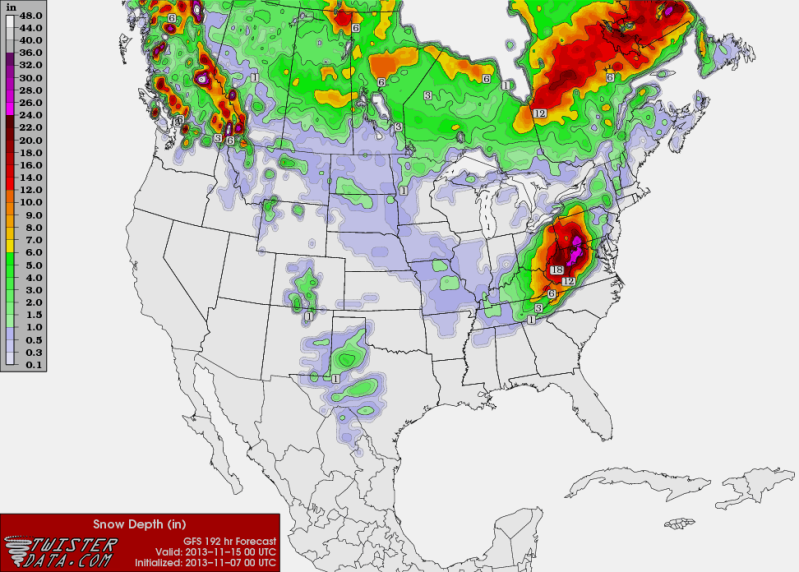
0zGFS snow forecast for next Thursday November 14..
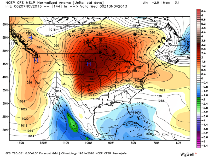
0zGFS Sea level pressure forecast courtesy of Ryan Maue Twitter....1046MB High in 6 days!
Looks to me like the 0z runs of the GFS and ECMWF are hinting at some cold weather coming to Texas by the end of next week. 0zECMWF has a major winter storm for Oklahoma with snow as far south into Dallas by next Friday!
0zGFS snow forecast for next Thursday November 14..

0zGFS Sea level pressure forecast courtesy of Ryan Maue Twitter....1046MB High in 6 days!

0 likes
The following post is NOT an official forecast and should not be used as such. It is just the opinion of the poster and may or may not be backed by sound meteorological data. It is NOT endorsed by any professional institution including storm2k.org For Official Information please refer to the NHC and NWS products.
-
Portastorm
- Storm2k Moderator
- Posts: 9954
- Age: 63
- Joined: Fri Jul 11, 2003 9:16 am
- Location: Round Rock, TX
- Contact:
Re: Texas Fall 2013
The 12z Euro operational run continues to show a major-league cold front for Texas for the middle of next week. Quite impressive for mid November.
0 likes
Any forecasts under my name are to be taken with a grain of salt. Get your best forecasts from the National Weather Service and National Hurricane Center.

-
Portastorm
- Storm2k Moderator
- Posts: 9954
- Age: 63
- Joined: Fri Jul 11, 2003 9:16 am
- Location: Round Rock, TX
- Contact:
Re:
dhweather wrote:I got about 1" total from Saturday-Tuesday.
But right now, I can't quit looking at Super Typhoon Haiyan - amazing. Gotta be contributing big time to the strong ridge in the Pacific.
You don't have a system like that which doesn't cause dramatic impacts downstream (i.e. CONUS). Next week should be very interesting.
0 likes
Any forecasts under my name are to be taken with a grain of salt. Get your best forecasts from the National Weather Service and National Hurricane Center.
The local CBS weather report is jumping on the cold front next week. Possible freeze with highs in the low 50's Wednesday and Thursday. Looks like the main arctic air stays north and east but the map sure looked pretty. Bring it!  Would this front be a result of the typhoon currently slamming the Philippines?
Would this front be a result of the typhoon currently slamming the Philippines?
0 likes
Return to “USA & Caribbean Weather”
Who is online
Users browsing this forum: No registered users and 11 guests