Florida Weather

U.S. & Caribbean Weather Discussions and Severe Weather Events

Moderator: S2k Moderators

Forum rules

The posts in this forum are NOT official forecast and should not be used as such. They are just the opinion of the poster and may or may not be backed by sound meteorological data. They are NOT endorsed by any professional institution or STORM2K.

Help Support Storm2K
Message
Author
TheStormExpert

#8261 Postby TheStormExpert » Sun Jan 19, 2014 8:14 pm

Sadly, it looks as if this brief pattern change will end (for at least the southern half of the FL peninsula) come the end of January/beginning of February. According to the latest CPC temp. outlooks the 6-10 Day outlook still shows the current Below Average temps. for Jan. 25-29. Then the 8-14 Day outlook starts to bring Above Average temps. for the extreme southern part of the peninsula.

:darrow: (6-10 Day Outlook)
Image

:darrow: (8-14 Day Outlook)
Image

Even today's NAEFS Temp. Anomaly Outlook for Days 8-14 show quite similar ideas.

:darrow: (00z 8-14 Day Outlook)
Image

:darrow: (12z 8-14 Day Outlook)
Image
0 likes   

User avatar
northjaxpro
S2K Supporter
S2K Supporter
Posts: 8900
Joined: Mon Sep 27, 2010 11:21 am
Location: Jacksonville, FL

#8262 Postby northjaxpro » Tue Jan 21, 2014 7:19 am

This pattern is just like a broken record as the dry parade of cold fronts continue their progressions through the peninsula. The broad upper level trough across the Eastern 2/3 of the CONUS will stay locked in place. This should keep the dry, northwestly flow aloft and generally cold pattern over most of the peninsula at least through the end of this month.

The next arctic front will push into the peninsula late tonight and early Wednesday. A intensifying winter storm is progged to be just off the DELMARVA region early Wednesday morning. This will combine with a strong Arctic High building south through the Plains will once again bring strong north-northwest winds on Wednesday . Very cold air will funnel straight down into the region. Expecting temps to fall into the upper 20s by dawn tomorrow morning across interior areas of the northern peninsula with wind chills from near 20 degrees.

It will be a close call down across the central peninsula in terms of temps getting to near freezing by Thursday morning. Temps will drop to near freezibg down along the I-4 corridor at that time. Will monitor closely.
0 likes   
NEVER, EVER SAY NEVER in the tropics and weather in general, and most importantly, with life itself!!

________________________________________________________________________________________

Fay 2008 Beryl 2012 Debby 2012 Colin 2016 Hermine 2016 Julia 2016 Matthew 2016 Irma 2017 Dorian 2019

User avatar
northjaxpro
S2K Supporter
S2K Supporter
Posts: 8900
Joined: Mon Sep 27, 2010 11:21 am
Location: Jacksonville, FL

#8263 Postby northjaxpro » Wed Jan 22, 2014 8:44 am

Bottomed out at 30.4 degrees at my home this morning. Cold advection continues today and with High pressure axis building in over the area from the west, max temps expected only in the upper 40s.

Tonight, winds will become light to calm in my areas with the cold modifed Arctic High positioned over the peninsula. We will see ideal radiational cooling conditions statewide tonight. It will be colder statewide tonight and hard freeze conditions appear likely across the northern peninsula tonight. Temps will get down into the low-mid 20s across the Big Bend and Suwannee River Valley to the mid-upper 20s across Northeast Florida by sunrise tomorrow morning.

Looks as if the freeze line will get deep into the central peninsula tomorrow morning as temps will get right at the freeze mark or even slighly below it. Ocala and Brooksville may see readings in the upper 20s, as well as other spots along the Nature Coast as well. Also, areas on the Space Coast from Titusville to Vero Beach will see temps get close to freezing by early tomorrow morning. Also, with ideal radiational cooling conditions, there will be areas where frost will settle as well.

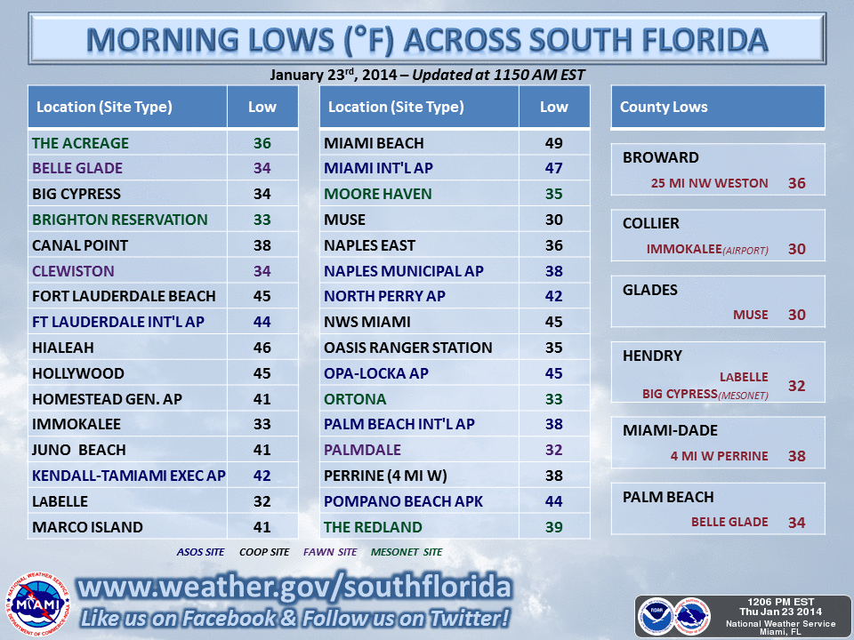
South Florida is looking at temps mainly in the low-mid 40s by tomorrow morning, but areas in interior southern peninsula and just north and west of Lake Okeechobee may see temps in the mid-upper 30s.

A very brief warm-up on Thursday as weak warm air advection will occur ahead of the next arctic dry front, which will come through the North Florida area late Thursday afternoon and the southern peninsula on early Friday. Models are progging a very strong 1048 mb Arctic High dome to sink south from the Plains all the way to Lower Mississippi Valley region by late Friday afternoon. Friday looks to be a very cold day across North Florida as current guidance are progging highs only to reach the low-mid 40s with strong CAA and brisk northerly winds. This will bring in more polar air into the peninsula, with freezes expected across North Florida on both Friday and Saturday mornings.

The broken record scenario looks to continue long range as models appears to keep this pattern in place into the first week of February as the large upper level trough is well entrenched across the Eastern 2/3 of the CONUS and stout ridging continues across the EPAC and Western U.S. This pattern will continue with delivering cold fronts every 2- 3 days or so with each bringing shots or pieces of modified polar airmasses to the Deep South and most of the Florida peninsula. The downside to this pattern, other than the cold, is that the northwest flow aloft is shutting off the GOM, which keeps these fronts coming through the area moisture starved.
0 likes   
NEVER, EVER SAY NEVER in the tropics and weather in general, and most importantly, with life itself!!

________________________________________________________________________________________

Fay 2008 Beryl 2012 Debby 2012 Colin 2016 Hermine 2016 Julia 2016 Matthew 2016 Irma 2017 Dorian 2019

User avatar
NDG
S2K Supporter
S2K Supporter
Posts: 15473
Joined: Sun Jul 09, 2006 10:14 pm
Location: Orlando, FL

Re: Florida Weather

#8264 Postby NDG » Wed Jan 22, 2014 6:19 pm

Hopefully the GFS ensembles are right in that the AO will go back near neutral with the PNA going negative and the NAO getting out of the neutral area back to positive, for our wx to go back at least to our average wx as we head into February, it can't get here soon enough!

Another frosty night for central FL tonight, with a light freeze in rural areas along I-4 corridor on southward. Good thing the 20s have not made this far south yet.

Image
Image
Image
0 likes   

User avatar
NDG
S2K Supporter
S2K Supporter
Posts: 15473
Joined: Sun Jul 09, 2006 10:14 pm
Location: Orlando, FL

Re: Florida Weather

#8265 Postby NDG » Thu Jan 23, 2014 7:21 am

Not as cold as Sunday morning but SW FL is once again as cold as central FL with a few spots even colder.

Image
0 likes   

User avatar
northjaxpro
S2K Supporter
S2K Supporter
Posts: 8900
Joined: Mon Sep 27, 2010 11:21 am
Location: Jacksonville, FL

#8266 Postby northjaxpro » Thu Jan 23, 2014 10:41 am

Good morning! The latest runs from GFS have peaked my curiosity today and talk about very intruiguing. NDG, have you seen the 0ZGFS runs? Apparently the GFS is latching onto the idea that the upcoming arctic airmass coming down next week could be the real deal, similar to the one we experienced the first week of this month. Also, GFS is also latching onto the idea that the southern stream will become active next week. 0Z GFS is showing a vigorous shortwave moving along the Gulf Coast and spreading moisture over the cold , arctic air dome, which will be in place middle-latter portions of next week. Folks, could we see the wintry precip along the Gulf Coast and into North Florida next week?

Check out the 156 hr 0Z GFS:

Image


156 hr

Image


Check out the 540 thickness line is right across North to Northeast Florida above which would support snow across the region should this verify. This is within 7 days, so I will definitely be paying close attention to this the next few days. Definitely interesting to see GFS showing this a week out.
0 likes   
NEVER, EVER SAY NEVER in the tropics and weather in general, and most importantly, with life itself!!

________________________________________________________________________________________

Fay 2008 Beryl 2012 Debby 2012 Colin 2016 Hermine 2016 Julia 2016 Matthew 2016 Irma 2017 Dorian 2019

User avatar
gatorcane
S2K Supporter
S2K Supporter
Posts: 23697
Age: 47
Joined: Sun Mar 13, 2005 3:54 pm
Location: Boca Raton, FL

#8267 Postby gatorcane » Thu Jan 23, 2014 2:44 pm

Saved image:

Image
0 likes   

User avatar
northjaxpro
S2K Supporter
S2K Supporter
Posts: 8900
Joined: Mon Sep 27, 2010 11:21 am
Location: Jacksonville, FL

#8268 Postby northjaxpro » Sat Jan 25, 2014 9:45 am

We received a fantastic reprieve thanks to the winter storm which impacted Texas and Louisiana the past 36 hours. The system was expected to get squashed southward, but instead the shortwave ejected moisture and clouds much farther east than was anticipated. The clouds and moisture kept all of North Florida above the freezing mark this morning, Also, weak upper level impulses that spreaded east did bring reports of sleet across the western panhandle overnight. Earlier this morning, the NWS office at Jacksonvile International Airport reported sleet pellets as well.

We will moderate briefly statewide this weekend as temps will warm to near 60 degrees for max temps today in Jax area and tomorrow. But, this will go away quickly as we have one more true polar blast of air arrving by Wednesday at the latest. Keeping a close watch with the models concerning the potential of possible wintry precip across extreme northern portions late Tuesday night into Wednesday morning. EURO and CMC and NAM on past runs were very agressive in showing a significant overunning precip event along the Gulf Coast east-northeast across North Florida to the Carolinas. GFS consistently keeps coming in as drier solution confing the moisture farther south and east.

Oh, finally, we may finally be seeing, at least for the time being, an end to this extreme cold pattern across the Eastern 2/3 of the nation and the peninsula by the start of February. There are finally indications in the long range models indicate ridging across the EPAC and Western U.S. finally breaking down. Hopefully, the deep upper level trough that has been entrenched across the entire Eastern U.S. for the entire month of January will finally loseit grip and retreat north.

Should hopefully get the fine details for this potential mid- week unusual event by Monday.
0 likes   
NEVER, EVER SAY NEVER in the tropics and weather in general, and most importantly, with life itself!!

________________________________________________________________________________________

Fay 2008 Beryl 2012 Debby 2012 Colin 2016 Hermine 2016 Julia 2016 Matthew 2016 Irma 2017 Dorian 2019

User avatar
NDG
S2K Supporter
S2K Supporter
Posts: 15473
Joined: Sun Jul 09, 2006 10:14 pm
Location: Orlando, FL

Re: Florida Weather

#8269 Postby NDG » Sat Jan 25, 2014 2:03 pm

:uarrow: I am glad the 12z Euro has backed away with its forecast of -12 deg C at H85 in northern FL, now jumping on board with the GFS of not a such an extreme Arctic shot for the FL Peninsula with the Arctic High Pressure center axis staying north of the Peninsula.
Because of cloud cover and precipitation the GFS and Euro do not show freezing temperatures for central FL with the upcoming shot but because of the same cloud cover and precipitation it will be a nasty cold day on Wednesday with highs possibly only in the 40s with some sections of north central FL stayin closer to the upper 30s.
After next week the pattern will be changing back to average if not above average with the GFS showing 80s back to central FL by next Saturday :)
So if indeed there will be no freezes for central FL for next week officially other than 3-4 frosty nights Orlando will come out with only one official light freeze, which occured on January 19th of 30 degrees but it was only for a couple of hours that it was subfreezing. We really lucked out it could had been worse with such a cold pattern in the eastern US.
JB is alreay talking about a very warm February, lets hope so 8-)
0 likes   

User avatar
FireRat
Category 5
Category 5
Posts: 1249
Age: 38
Joined: Sun Sep 26, 2010 11:38 pm
Location: North Carolina

Re: Florida Weather

#8270 Postby FireRat » Sun Jan 26, 2014 10:21 pm

Anyone seeing the massive temperature contrast expected across our state this Tuesday-Wednesday? Looks like there will be a temperature difference of 50 degrees from north to south in Florida, from WINTER in North Florida to nearly SUMMER in Southern Florida. Jacksonville might get sleet with a high in the 30s while Miami simmers under 80+ degree sunshine on the same day! Simply wow! Any mets wanna jump on board with that forecast? Seems as if South Florida were to have a shield against the "Polar Vortex" that will move down.
0 likes   
Georges '98, Irene '99, Frances '04, Jeanne '04, Katrina '05, Wilma '05, Gustav '08, Isaac '12, Matthew '16, Florence '18, Michael '18, Ian '22

SaskatchewanScreamer

#8271 Postby SaskatchewanScreamer » Mon Jan 27, 2014 9:11 pm

Is this true?
Image


If so aren't you fellows in the wrong forum?
0 likes   

User avatar
northjaxpro
S2K Supporter
S2K Supporter
Posts: 8900
Joined: Mon Sep 27, 2010 11:21 am
Location: Jacksonville, FL

#8272 Postby northjaxpro » Tue Jan 28, 2014 1:11 am

:uarrow: LOL... Well, I tell you this, this is how it may be by Wednesday on I-10 at the FL/AL border just outside of Pensacola. However, it will probably be more ice than snow there.
0 likes   
NEVER, EVER SAY NEVER in the tropics and weather in general, and most importantly, with life itself!!

________________________________________________________________________________________

Fay 2008 Beryl 2012 Debby 2012 Colin 2016 Hermine 2016 Julia 2016 Matthew 2016 Irma 2017 Dorian 2019

User avatar
northjaxpro
S2K Supporter
S2K Supporter
Posts: 8900
Joined: Mon Sep 27, 2010 11:21 am
Location: Jacksonville, FL

#8273 Postby northjaxpro » Tue Jan 28, 2014 12:15 pm

The NWS Jax office has finally posted a Winter Storm Watch for the NE Florida counties of Columbia, Suwanee, Hamilton, Union, Baker, Nassau and Duval. This includes the Jax metro area for the possibility of sleet and freezing rain by early tomorrow morning into Thursday morning. So, basically all the counties along the entire I-10 corridor in Florida is under Winter Storm Warnings or Watches.

O.NEW.KJAX.WS.A.0003.140129T1500Z-140130T1500Z/
HAMILTON-SUWANNEE-COLUMBIA-BAKER-NASSAU-DUVAL-UNION-
INCLUDING THE CITIES OF...JASPER...LIVE OAK...LAKE CITY...
MACCLENNY...FERNANDINA BEACH...JACKSONVILLE...LAKE BUTLER
1054 AM EST TUE JAN 28 2014

...WINTER STORM WATCH IN EFFECT FROM WEDNESDAY MORNING THROUGH
THURSDAY MORNING...

THE NATIONAL WEATHER SERVICE IN JACKSONVILLE HAS ISSUED A WINTER
STORM WATCH...WHICH IS IN EFFECT FROM WEDNESDAY MORNING THROUGH
THURSDAY MORNING.

* TIMING...RAIN MAY MIX WITH SLEET DURING THE LATE MORNING AND
EARLY AFTERNOON HOURS ALONG THE I-10 CORRIDOR. A FURTHER MIXTURE
OF RAIN...SLEET AND SNOW WILL BE POSSIBLE LATE WEDNESDAY
AFTERNOON INTO WEDNESDAY NIGHT. PRECIPITATION IS EXPECTED TO
COME TO AN END EARLY THURSDAY MORNING.

* MAIN IMPACT...TEMPERATURES FALLING BELOW FREEZING WEDNESDAY
NIGHT AND EARLY THURSDAY MORNING WILL PRODUCE ICY CONDITIONS ON
ROADWAYS.

* OTHER IMPACTS...ANY FROZEN PRECIPITATION ACCUMULATIONS SHOULD BE
MINIMAL SINCE TEMPERATURES FOR MOST OF THE EVENT SHOULD BE JUST
ABOVE FREEZING. SOME ACCUMULATION MAY OCCUR ON GRASSY AREAS AND
OVERPASSES AND BRIDGES WEDNESDAY EVENING...ESPECIALLY OVER THE
SUWANNEE RIVER VALLEY WEST OF JACKSONVILLE.
0 likes   
NEVER, EVER SAY NEVER in the tropics and weather in general, and most importantly, with life itself!!

________________________________________________________________________________________

Fay 2008 Beryl 2012 Debby 2012 Colin 2016 Hermine 2016 Julia 2016 Matthew 2016 Irma 2017 Dorian 2019

User avatar
Hurricane Alexis
Category 2
Category 2
Posts: 683
Age: 29
Joined: Thu Jun 14, 2012 7:59 pm
Location: Miami,Florida

Re: Florida Weather

#8274 Postby Hurricane Alexis » Tue Jan 28, 2014 11:14 pm

I can't believe there's snow in Florida. I guess i'm too young.
0 likes   
Personal Forecast Disclaimer:
The posts in this forum are NOT official forecast and should not be used as such. They are just the opinion of the poster and may or may not be backed by sound meteorological data. They are NOT endorsed by any professional institution or storm2k.org. For official information, please refer to the NHC and NWS products.

TheStormExpert

Re: Florida Weather

#8275 Postby TheStormExpert » Wed Jan 29, 2014 12:05 am

Hurricane Alexis wrote:I can't believe there's snow in Florida. I guess i'm too young.

What makes it even weirder is that none of that cold arctic air helping to produce the ice/snow will make it down the peninsula of Florida. So South Florida (unlike what we saw the past two weeks with constant arctic fronts working through every 3-4 days) will stay in this warm summer like pattern that we have been in the majority of this winter.
0 likes   

User avatar
northjaxpro
S2K Supporter
S2K Supporter
Posts: 8900
Joined: Mon Sep 27, 2010 11:21 am
Location: Jacksonville, FL

#8276 Postby northjaxpro » Wed Jan 29, 2014 8:02 am

What an incredible day of weather yesterday across the state of Florida. The panhandle saw a mixed bag of light snow,freezing rain and sleet. Meanwhile, areas in South Florida experienced temps nearly 50 degrees warmer than areas in the panhandle.

Winter Storm Watch will stay in place across the counties on the I-10 corridor east of I-75 into the Jax area. Meanwhile, Winter Storm Warning continues from Madison county westward to Tallahassee There is still plenty of moisture and ripples of impulses in the southern stream that sretches west/southwest well into the GOM and will stream rain all day into tonight. There will be sleet in areas across the I-10 corridor and points northward, especial across extreme Southeast Goegia. The shallow arctic air mass is in place and temperature at my locale is currently 34.6 degrees. The tenperaturs are stuck today as they are expected to remain in the 30s the entire day across the entire area along the I-10 corridor and points northward. Thankfully, the temps will hover just above freezing to keep freezing rain at bay, but all it would take is for the temps to get to that freezing mark and we will be looking at serious concerns. Watching this carefully. It will definitely be one of the coldestdays of the season and the rain and wind chills into the upper 20s during the day really will make this feel raw.
0 likes   
NEVER, EVER SAY NEVER in the tropics and weather in general, and most importantly, with life itself!!

________________________________________________________________________________________

Fay 2008 Beryl 2012 Debby 2012 Colin 2016 Hermine 2016 Julia 2016 Matthew 2016 Irma 2017 Dorian 2019

User avatar
gatorcane
S2K Supporter
S2K Supporter
Posts: 23697
Age: 47
Joined: Sun Mar 13, 2005 3:54 pm
Location: Boca Raton, FL

#8277 Postby gatorcane » Wed Jan 29, 2014 4:00 pm

Looking at OBS this afternoon. What a stark contrast between the the Panhandle of Florida and South Florida. 20s and 30s across North Florida...and 70s for the most part across South Florida.

CRESTVIEW CLOUDY 25 18 74 N7 30.36S WCI 17

MIAMI LGT RAIN 74 70 87 SE6 29.99S
0 likes   

SouthFloridian92
Tropical Storm
Tropical Storm
Posts: 120
Age: 32
Joined: Tue Dec 11, 2012 4:50 pm
Location: Sebring, Florida

Re: Florida Weather

#8278 Postby SouthFloridian92 » Wed Jan 29, 2014 5:10 pm

Sure wish I was up there in Northern FL with the cold and the snow.
0 likes   

User avatar
NDG
S2K Supporter
S2K Supporter
Posts: 15473
Joined: Sun Jul 09, 2006 10:14 pm
Location: Orlando, FL

Re: Florida Weather

#8279 Postby NDG » Wed Jan 29, 2014 10:36 pm

Well, I guess the Winter Storm warning for NE FL from Tallahassee on eastward was a bust.
Funny how some local TV Mets here Orlando keep saying that what the radar shows tonight of "snow" is coming across I-10 into I-75 interception, why would they not look at the actual surface reports and see that the precipitation that the radar shows as snow is not reaching the ground at all, heck H85 temps tonight do not support snow east of Tallahasse along I-10, they even had a live crew in Lake City reporting tonight waiting for them to report the snow, lol.
0 likes   

User avatar
FireRat
Category 5
Category 5
Posts: 1249
Age: 38
Joined: Sun Sep 26, 2010 11:38 pm
Location: North Carolina

Re: Florida Weather

#8280 Postby FireRat » Thu Jan 30, 2014 1:11 am

South Florida's missing out on the ice and snow, but sure feeling a drop in degrees...at least inland. Currently 57 degrees and dropping with a cool mist here in Western Broward. Funny how local reports from Pompano and Boca Raton show high 60s right now! Must be a NNE wind to blame for sure! At this rate we may get to low 50s perhaps high 40s across interior S. Florida which is much cooler than what was initially thought for lows tonight IMO.
0 likes   
Georges '98, Irene '99, Frances '04, Jeanne '04, Katrina '05, Wilma '05, Gustav '08, Isaac '12, Matthew '16, Florence '18, Michael '18, Ian '22


Return to “USA & Caribbean Weather”

Who is online

Users browsing this forum: No registered users and 147 guests