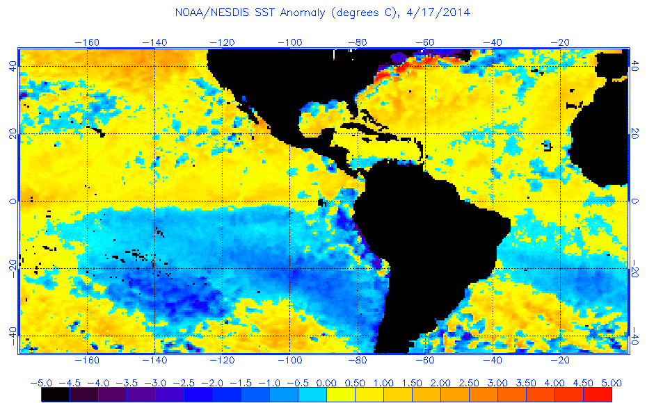
ENSO Updates (2007 thru 2023)

This is the general tropical discussion area. Anyone can take their shot at predicting a storms path.

Moderator: S2k Moderators

Forum rules

The posts in this forum are NOT official forecasts and should not be used as such. They are just the opinion of the poster and may or may not be backed by sound meteorological data. They are NOT endorsed by any professional institution or STORM2K. For official information, please refer to products from the National Hurricane Center and National Weather Service.

Help Support Storm2K
Message
Author
User avatar
Yellow Evan
Professional-Met
Professional-Met
Posts: 16143
Age: 27
Joined: Fri Jul 15, 2011 12:48 pm
Location: Henderson, Nevada/Honolulu, HI
Contact:

Re: Re:

#4141 Postby Yellow Evan » Sat Apr 19, 2014 10:20 pm

stormkite wrote:
Ntxw wrote:
stormkite wrote:SOI is about the same as 2012
Im still staggered why anyone would be comparing this El nino coming with 1997/98 Super nino.

They are nothing alike, we may get a brief moderate event or we could see the biggest flop in history. Ignore the cold PDO all you like, the strong ones just do not occur in this period no matter how much subsurface warming happens.

The trades are not going to switch, meaning the teleconnection between atmosphere and ocean looks weak at best.

I will wait another month and then I'm tipping the models will jump ship, there is no more heat in the pipeline


SOI is also similar to 2002. Lower than 2009 and 2006 neither fell until summer. Everyone is is entitled to their opinion. Why would you be staggered at the comparisons? This is what the professionals have put out not us. They compare it to 1997 because that is what the weather events did, bursts. Whether it is to continue is anyone's guess. And your statement of strong ones do not occur in cold PDO era (even with the recent spike warm) is not correct. See 1972.


I meant we are in a 25 year cold phase. Yes we are positive atm.

Every cold PDO has positive phases, but overall the behaviour is cold PDO which is why El ninos average 9 months in a cold PDO and La Ninas 21 months.

There is nothing in the analogs that suggests a strong Nino bar 1972/73, even though that one was also brief and about 9 months. So the odds are stacked against it.


You are right in the odds don't have a long lasting El Nino, but honestly, really only the epicly positive PDO+ ones tend to last longer than a year, and some of those even (like 1977-78) were brief

1972-73 is a Super El Nino. 1997-98 is of course, and that lasted ~12 months.
0 likes   

User avatar
Ntxw
Storm2k Moderator
Storm2k Moderator
Posts: 22786
Joined: Wed Oct 21, 2009 6:34 pm
Location: DFW, Texas

#4142 Postby Ntxw » Sat Apr 19, 2014 10:44 pm

Since the next CPC update is Monday here is some milestone values to ponder.

1997 Week centered on the 16th (same as this week and the update on Monday) saw +0.3C.
The following week centered on the 23rd (next week) saw the big jump to +0.6C and then that was it no more less than that until a year later.

First +1C reading came the final week of May.
0 likes   
The above post and any post by Ntxw is NOT an official forecast and should not be used as such. It is just the opinion of the poster and may or may not be backed by sound meteorological data. It is NOT endorsed by any professional institution including Storm2k. For official information, please refer to NWS products.

  Help support Storm2K!
Help Support Storm2K

User avatar
Yellow Evan
Professional-Met
Professional-Met
Posts: 16143
Age: 27
Joined: Fri Jul 15, 2011 12:48 pm
Location: Henderson, Nevada/Honolulu, HI
Contact:

Re:

#4143 Postby Yellow Evan » Sat Apr 19, 2014 10:46 pm

Ntxw wrote:Since the next CPC update is Monday here is some milestone values to ponder.

1997 Week centered on the 16th (same as this week and the update on Monday) saw +0.3C.
The following week centered on the 23rd (next week) saw the big jump to +0.6C and then that was it no more less than that until a year later.

First +1C reading came the final week of May.


What was the highest weekly reading during the 97-98 El Nino?
0 likes   

User avatar
Ntxw
Storm2k Moderator
Storm2k Moderator
Posts: 22786
Joined: Wed Oct 21, 2009 6:34 pm
Location: DFW, Texas

Re: Re:

#4144 Postby Ntxw » Sat Apr 19, 2014 10:49 pm

Yellow Evan wrote:What was the highest weekly reading during the 97-98 El Nino?


+2.8C final week of November. Greater than 2.5C appeared in early October and lasted through early February.
0 likes   
The above post and any post by Ntxw is NOT an official forecast and should not be used as such. It is just the opinion of the poster and may or may not be backed by sound meteorological data. It is NOT endorsed by any professional institution including Storm2k. For official information, please refer to NWS products.


  Help support Storm2K!

Help Support Storm2K


User avatar
Yellow Evan
Professional-Met
Professional-Met
Posts: 16143
Age: 27
Joined: Fri Jul 15, 2011 12:48 pm
Location: Henderson, Nevada/Honolulu, HI
Contact:

#4145 Postby Yellow Evan » Sat Apr 19, 2014 11:00 pm

As for next weeks reading, I'm going with either +0.4C or +0.5C
0 likes   

User avatar
xtyphooncyclonex
Category 5
Category 5
Posts: 3861
Age: 23
Joined: Sat Dec 08, 2012 9:07 am
Location: Cebu City
Contact:

#4146 Postby xtyphooncyclonex » Sun Apr 20, 2014 12:21 am

30-day averaged SOI now is at +0.7, this means that this is the first time since February/March that it was positive.
0 likes   
REMINDER: My opinions that I, or any other NON Pro-Met in this forum, are unofficial. Please do not take my opinions as an official forecast and warning. I am NOT a meteorologist. Following my forecasts blindly may lead to false alarm, danger and risk if official forecasts from agencies are ignored.

User avatar
xtyphooncyclonex
Category 5
Category 5
Posts: 3861
Age: 23
Joined: Sat Dec 08, 2012 9:07 am
Location: Cebu City
Contact:

#4147 Postby xtyphooncyclonex » Sun Apr 20, 2014 12:36 am

In my opinion, this could be at LEAST a moderate El Nino. However, a strong El Nino is very likely and a super is possible.

Aren't we seeing now some of the warmest subsurface waters for this month? I guess we quite underestimated the strength of that pool.
0 likes   
REMINDER: My opinions that I, or any other NON Pro-Met in this forum, are unofficial. Please do not take my opinions as an official forecast and warning. I am NOT a meteorologist. Following my forecasts blindly may lead to false alarm, danger and risk if official forecasts from agencies are ignored.

User avatar
Yellow Evan
Professional-Met
Professional-Met
Posts: 16143
Age: 27
Joined: Fri Jul 15, 2011 12:48 pm
Location: Henderson, Nevada/Honolulu, HI
Contact:

Re:

#4148 Postby Yellow Evan » Sun Apr 20, 2014 1:10 am

xtyphooncyclonex wrote:In my opinion, this could be at LEAST a moderate El Nino. However, a strong El Nino is very likely and a super is possible.

Aren't we seeing now some of the warmest subsurface waters for this month? I guess we quite underestimated the strength of that pool.


I don't think so. We've been tracking how warm the subsurface is for months. If anything, we slightly overestimated.
0 likes   

User avatar
NDG
S2K Supporter
S2K Supporter
Posts: 15446
Joined: Sun Jul 09, 2006 10:14 pm
Location: Orlando, FL

Re: Re:

#4149 Postby NDG » Sun Apr 20, 2014 7:34 am

Yellow Evan wrote:
xtyphooncyclonex wrote:In my opinion, this could be at LEAST a moderate El Nino. However, a strong El Nino is very likely and a super is possible.

Aren't we seeing now some of the warmest subsurface waters for this month? I guess we quite underestimated the strength of that pool.


I don't think so. We've been tracking how warm the subsurface is for months. If anything, we slightly overestimated.


I am not buying the forecast for a moderate to strong typical eastern based El Nino until I start seeing waters along Nino 1+2 & coastal S.A. America really start warming up, they have been persistently cool, and all that cool water south of the Equator (indicative of strong easterly winds still present) is probably cooling a lot of that warm subsurface waters as it surfaces. A lot of you are comparing this event to 97 but if it wants now catch up to that year we better start seeing some warm waters surfacing this week coming up.

Image
0 likes   

User avatar
Ntxw
Storm2k Moderator
Storm2k Moderator
Posts: 22786
Joined: Wed Oct 21, 2009 6:34 pm
Location: DFW, Texas

#4150 Postby Ntxw » Sun Apr 20, 2014 8:23 am

Here is a really cool link posted not long ago by Dr. Ventrice and WSI of the ocean currents. Warning though it's fairly sizeable but can be moved to any area of the globe.

http://earth.nullschool.net/#current/ocean/surface/currents/orthographic=-143.29,1.18,588
0 likes   
The above post and any post by Ntxw is NOT an official forecast and should not be used as such. It is just the opinion of the poster and may or may not be backed by sound meteorological data. It is NOT endorsed by any professional institution including Storm2k. For official information, please refer to NWS products.


  Help support Storm2K!

Help Support Storm2K


User avatar
xtyphooncyclonex
Category 5
Category 5
Posts: 3861
Age: 23
Joined: Sat Dec 08, 2012 9:07 am
Location: Cebu City
Contact:

Re: Re:

#4151 Postby xtyphooncyclonex » Sun Apr 20, 2014 8:53 am

Yellow Evan wrote:
xtyphooncyclonex wrote:In my opinion, this could be at LEAST a moderate El Nino. However, a strong El Nino is very likely and a super is possible.

Aren't we seeing now some of the warmest subsurface waters for this month? I guess we quite underestimated the strength of that pool.


I don't think so. We've been tracking how warm the subsurface is for months. If anything, we slightly overestimated.

This is the first time since 1997 that we have seen anomalies of +6C beneath the equator. It deserves much attention. This is rare for the first third of the year. Most El Nino years had this only just during their peak on the later part of the year.
0 likes   
REMINDER: My opinions that I, or any other NON Pro-Met in this forum, are unofficial. Please do not take my opinions as an official forecast and warning. I am NOT a meteorologist. Following my forecasts blindly may lead to false alarm, danger and risk if official forecasts from agencies are ignored.

User avatar
Yellow Evan
Professional-Met
Professional-Met
Posts: 16143
Age: 27
Joined: Fri Jul 15, 2011 12:48 pm
Location: Henderson, Nevada/Honolulu, HI
Contact:

Re: Re:

#4152 Postby Yellow Evan » Sun Apr 20, 2014 9:31 am

NDG wrote:
Yellow Evan wrote:
xtyphooncyclonex wrote:In my opinion, this could be at LEAST a moderate El Nino. However, a strong El Nino is very likely and a super is possible.

Aren't we seeing now some of the warmest subsurface waters for this month? I guess we quite underestimated the strength of that pool.


I don't think so. We've been tracking how warm the subsurface is for months. If anything, we slightly overestimated.


I am not buying the forecast for a moderate to strong typical eastern based El Nino until I start seeing waters along Nino 1+2 & coastal S.A. America really start warming up, they have been persistently cool, and all that cool water south of the Equator (indicative of strong easterly winds still present) is probably cooling a lot of that warm subsurface waters as it surfaces. A lot of you are comparing this event to 97 but if it wants now catch up to that year we better start seeing some warm waters surfacing this week coming up.

Image


Nino 1+2 has warmed a past week. N above average anomalies are located N of the equator.
0 likes   

User avatar
cycloneye
Admin
Admin
Posts: 145366
Age: 68
Joined: Thu Oct 10, 2002 10:54 am
Location: San Juan, Puerto Rico

Re: ENSO Updates

#4153 Postby cycloneye » Sun Apr 20, 2014 9:37 am

Here is the truth according to the data since 1990. Time is running out for 2014 to be the same as 1997 super El Nino as presently there is a slim advantage to 2014 at Nino 3.4 as it was at +0.3C in April 16 1997 and now is at +0.5C. But there is a big difference in Nino 1+2 data as 1997 was way ahead at +1.1C while right now is at -0.3C. Let's see how things progress in the next couple of weeks.

http://www.cpc.ncep.noaa.gov/data/indices/wksst8110.for
0 likes   
Visit the Caribbean-Central America Weather Thread where you can find at first post web cams,radars
and observations from Caribbean basin members Click Here

OURAGAN
Category 1
Category 1
Posts: 451
Joined: Sat Aug 07, 2004 12:18 pm
Location: GUADELOUPE

Re: ENSO Updates

#4154 Postby OURAGAN » Sun Apr 20, 2014 9:56 am

[img][http://www.ospo.noaa.gov/data/sst/anomaly/1997/anomnight.4.19.1997.gif/img]
0 likes   

User avatar
Ntxw
Storm2k Moderator
Storm2k Moderator
Posts: 22786
Joined: Wed Oct 21, 2009 6:34 pm
Location: DFW, Texas

Re: ENSO Updates

#4155 Postby Ntxw » Sun Apr 20, 2014 9:57 am

I wouldn't call it time is running out. We are still only in the first quarter of the year, ENSO is a long drawn out process. 1982 rose to near 1997 levels but not until later year after starting very slow. Will we get a super Nino? No one has the answer only guesses using various methods and biases. It's pretty amazing that enso is such a big weather phenomonen yet we have such limited skill forecasting it.
0 likes   
The above post and any post by Ntxw is NOT an official forecast and should not be used as such. It is just the opinion of the poster and may or may not be backed by sound meteorological data. It is NOT endorsed by any professional institution including Storm2k. For official information, please refer to NWS products.


  Help support Storm2K!

Help Support Storm2K


OURAGAN
Category 1
Category 1
Posts: 451
Joined: Sat Aug 07, 2004 12:18 pm
Location: GUADELOUPE

Re: ENSO Updates

#4156 Postby OURAGAN » Sun Apr 20, 2014 9:57 am

Image
0 likes   

OURAGAN
Category 1
Category 1
Posts: 451
Joined: Sat Aug 07, 2004 12:18 pm
Location: GUADELOUPE

Re: ENSO Updates

#4157 Postby OURAGAN » Sun Apr 20, 2014 10:00 am

A big différence at nino 1-2 in 1997, at the same date, a lot of Warmer in 1997
0 likes   

User avatar
Ntxw
Storm2k Moderator
Storm2k Moderator
Posts: 22786
Joined: Wed Oct 21, 2009 6:34 pm
Location: DFW, Texas

Re: ENSO Updates

#4158 Postby Ntxw » Sun Apr 20, 2014 10:03 am

OURAGAN wrote:A big différence at nino 1-2 in 1997, at the same date, a lot of Warmer in 1997


Also interesting that there was a cold tongue coming off mexico and SW US typical more to cold PDO. Is this why 1997 saw a weaker +PDO reading?
0 likes   
The above post and any post by Ntxw is NOT an official forecast and should not be used as such. It is just the opinion of the poster and may or may not be backed by sound meteorological data. It is NOT endorsed by any professional institution including Storm2k. For official information, please refer to NWS products.


  Help support Storm2K!

Help Support Storm2K


asd123
Category 1
Category 1
Posts: 265
Joined: Tue Sep 06, 2011 7:06 pm
Location: Orlando, Florida

#4159 Postby asd123 » Sun Apr 20, 2014 10:07 am

What happened to the CDAS SFLUX SST anomaly map? It hasn't updated since 18z Saturday. The map is usually updated 3 or 4 hours after the time z. (ie 3 or 4 hours after 18z)
0 likes   
This post is NOT AN OFFICIAL FORECAST and should not be used as such. It is just the opinion of the poster and may or may not be backed by sound meteorological data. It is NOT endorsed by any professional institution including storm2k.org. For Official Information please refer to the NHC and NWS products.

User avatar
Yellow Evan
Professional-Met
Professional-Met
Posts: 16143
Age: 27
Joined: Fri Jul 15, 2011 12:48 pm
Location: Henderson, Nevada/Honolulu, HI
Contact:

Re: ENSO Updates

#4160 Postby Yellow Evan » Sun Apr 20, 2014 10:31 am

Ntxw wrote:
OURAGAN wrote:A big différence at nino 1-2 in 1997, at the same date, a lot of Warmer in 1997


Also interesting that there was a cold tongue coming off mexico and SW US typical more to cold PDO. Is this why 1997 saw a weaker +PDO reading?


Yes, if I had to make a guess. It probs limited 1997 PHS NS count a little. Intresting to note.

How much does 1+2 matter?

I don't think the best analog is 1997, but rather 1972. Regarding 1982, that was at the height of an epic +PDO period.
0 likes   


Return to “Talkin' Tropics”

Who is online

Users browsing this forum: Javlin, jlauderdal, riapal, TomballEd, USTropics and 51 guests