TROPICAL WEATHER OUTLOOK
NWS NATIONAL HURRICANE CENTER MIAMI FL
800 PM EDT THU JUN 26 2014
For the North Atlantic...Caribbean Sea and the Gulf of Mexico:
An area of low pressure could form off the southeastern coast of
the United States this weekend and linger into early next week.
Some development of this system is possible if it remains over
water.
* Formation chance through 48 hours...low...near 0 percent.
* Formation chance through 5 days...low...20 percent.
$$
Forecaster Brennan
Off SE U.S coast (Is Invest 91L)
Moderator: S2k Moderators
Forum rules

The posts in this forum are NOT official forecasts and should not be used as such. They are just the opinion of the poster and may or may not be backed by sound meteorological data. They are NOT endorsed by any professional institution or STORM2K. For official information, please refer to products from the National Hurricane Center and National Weather Service.
-
cycloneye

- Admin

- Posts: 149505
- Age: 69
- Joined: Thu Oct 10, 2002 10:54 am
- Location: San Juan, Puerto Rico
0 likes
Visit the Caribbean-Central America Weather Thread where you can find at first post web cams,radars
and observations from Caribbean basin members Click Here
and observations from Caribbean basin members Click Here

-
tropicwatch

- Category 5

- Posts: 3426
- Age: 62
- Joined: Sat Jun 02, 2007 10:01 am
- Location: The Villages, Florida
- Contact:
Re: Off SE U.S coast?
That would be a perfect set up for a developing system.
0 likes
Tropicwatch
Agnes 72', Eloise 75, Elena 85', Kate 85', Charley 86', Florence 88', Beryl 94', Dean 95', Erin 95', Opal 95', Earl 98', Georges 98', Ivan 2004', Arlene 2005', Dennis 2005', Ida 2009' Debby 2012' Irma 2017' Michael 2018'
Agnes 72', Eloise 75, Elena 85', Kate 85', Charley 86', Florence 88', Beryl 94', Dean 95', Erin 95', Opal 95', Earl 98', Georges 98', Ivan 2004', Arlene 2005', Dennis 2005', Ida 2009' Debby 2012' Irma 2017' Michael 2018'
-
cycloneye
- Admin
- Posts: 149505
- Age: 69
- Joined: Thu Oct 10, 2002 10:54 am
- Location: San Juan, Puerto Rico
Re: Off SE U.S coast?
A circle on land. Is not often that they put circles overland. 
TROPICAL WEATHER OUTLOOK
NWS NATIONAL HURRICANE CENTER MIAMI FL
800 AM EDT FRI JUN 27 2014
For the North Atlantic...Caribbean Sea and the Gulf of Mexico:
A non-tropical area of low pressure over South Carolina is
expected to move offshore of the southeastern United States this
weekend. Some development of this system is possible while it
lingers off the southeastern coast of the United States early next
week.
* Formation chance through 48 hours...low...near 0 percent.
* Formation chance through 5 days...low...20 percent.
$$
Forecaster Blake
0 likes
Visit the Caribbean-Central America Weather Thread where you can find at first post web cams,radars
and observations from Caribbean basin members Click Here
and observations from Caribbean basin members Click Here
-
HurricaneBelle

- S2K Supporter

- Posts: 1209
- Joined: Sun Aug 27, 2006 6:12 pm
- Location: Clearwater, FL
Re: Off SE U.S coast?
cycloneye wrote:A circle on land. Is not often that they put circles overland.
The West Atlantic equivalent of waiting for a wave to come off Africa.
0 likes
Re: Off SE U.S coast?
A circle over land - how the NHC has changed over the past 30 years - and not for the better!!!
The GFS shows a very weak low over water and then dissipates it once it cycles back over land - the NHC must be getting anxious for lack of work...
Frank
The GFS shows a very weak low over water and then dissipates it once it cycles back over land - the NHC must be getting anxious for lack of work...
Frank
0 likes

Re: Off SE U.S coast?
Frank2 wrote:A circle over land - how the NHC has changed over the past 30 years - and not for the better!!!
The GFS shows a very weak low over water and then dissipates it once it cycles back over land - the NHC must be getting anxious for lack of work...
Frank
Huh? They are identifying a possible system as they should, that has a 5 day development chance. The 1970s way of waiting until it is developed to mention it is gone. This IS a change for the better
0 likes
-
StarmanHDB

- Tropical Storm

- Posts: 202
- Age: 61
- Joined: Wed Sep 02, 2009 7:59 pm
- Location: West Palm Beach, Florida
Re: Off SE U.S coast?
Frank2 wrote:A circle over land - how the NHC has changed over the past 30 years - and not for the better!!!
The GFS shows a very weak low over water and then dissipates it once it cycles back over land - the NHC must be getting anxious for lack of work...
Frank
So in other words, by using the latest science and technology to give people advanced notice of a possible tropical system, the NHC is actually doing harm (your stating that such changes put in place by an institution specifically designed to protect millions of people are "not for the better" implies harm)?
Although I like to consider myself reasonably intelligent, I know that I'm not the only member of this site that doesn't understand your reasoning. That said, can you please explain your reasoning so it makes clear sense because as I'm reading it now, it makes absolutely no sense at all?
Thanks!
0 likes
-
SeGaBob
I sense 91L coming once this moves offshore..
The posts in this forum are NOT official forecast and should not be used as such. They are just the opinion of the poster and may or may not be backed by sound meteorological data. They are NOT endorsed by any professional institution or storm2k.org. For official information, please refer to the NHC and NWS products.
The posts in this forum are NOT official forecast and should not be used as such. They are just the opinion of the poster and may or may not be backed by sound meteorological data. They are NOT endorsed by any professional institution or storm2k.org. For official information, please refer to the NHC and NWS products.
0 likes
-
floridasun78
- Category 5
- Posts: 3755
- Joined: Sun May 17, 2009 10:16 pm
- Location: miami fl
Re: Off SE U.S coast?
i think we saw some thing like this before invest came from low was coming off coast but their been only few case of this happening
0 likes
-
OuterBanker
- S2K Supporter
- Posts: 1761
- Joined: Wed Feb 26, 2003 10:53 am
- Location: Nags Head, NC
- Contact:
Re: Off SE U.S coast?
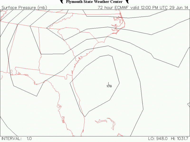
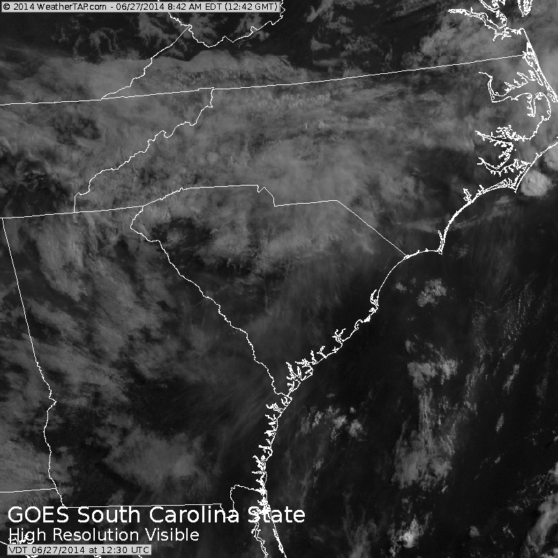
Didn’t see much support from the models this am. But after looking at the visible around noon there seems to be a spin up right where the yellow circle is in SC. Would feel a lot different is that monster 995 mb low in the upper Midwest was exiting. Last check on the SC low was around 1014 mb. Pretty high, but it is lower than that spin up off Fl last week if I remember correctly.
http://mp1.met.psu.edu/~fxg1/SAT_SE/anim16vis.html
http://mp1.met.psu.edu/~fxg1/SAT_SE/anim16vis.html
0 likes
-
cycloneye
- Admin
- Posts: 149505
- Age: 69
- Joined: Thu Oct 10, 2002 10:54 am
- Location: San Juan, Puerto Rico
Re: Off SE U.S coast?
Dr Jeff Masters made a good discussion about this.
A blow-up of thunderstorms over Texas and Louisiana on Wednesday created an area of low pressure that tracked east-northeast over the Southeast U.S., and was over Georgia and South Carolina on Friday. This low will emerge over the coastal South Carolina waters on Saturday, and move over the warm waters of the Gulf Stream current by Sunday. Sea surface temperature in this region are about 1°C above average, 27 - 28°C, which is plenty of heat energy for a developing tropical cyclone. Wind shear is moderate, 10 - 20 knots, and is forecast to remain moderate through Monday. These conditions favor development, though the 00Z Friday runs of our reliable tropical cyclone genesis models--the GFS, European, and UKMET--did not show development into a tropical depression. The disturbance will be in an area of weak steering currents, and the predominant track favored by the models is a slow south and then southwest movement towards Florida. The latest thinking from NOAA's Weather Prediction Center (Figure 1) is that the disturbance will bring a swath of 2 - 4" of rain from North Carolina to Florida during the coming week. These rainfall totals will be higher if the disturbance develops into a tropical depression. However, the system may not have much time over water before moving ashore over Florida on Monday, if the 00Z and 06Z Friday runs of the GFS model are correct. In their 8 am EDT Friday Tropical Weather Outlook, NHC gave the system 2-day and 5-day odds of development of 0% and 20%, respectively.
0 likes
Visit the Caribbean-Central America Weather Thread where you can find at first post web cams,radars
and observations from Caribbean basin members Click Here
and observations from Caribbean basin members Click Here
-
hurricanetrack

- HurricaneTrack.com
- Posts: 1781
- Joined: Tue Dec 02, 2003 10:46 pm
- Location: Wilmington, NC
- Contact:
The idea of putting an outlook up for weather systems over land was talked about during the Tropical Weather Conference in April. To suggest the NHC staff is bored to the point of making stuff up is an insult to their reputation and their intellect. It does not take a hurricane to cause problems for people. Consider this: the low moves off of the land mass and in to the warm Atlantic waters, becomes even a little bit stronger, maybe never even makes it to depression status but more organized none the less. Don't you think that boaters who venture offshore, perhaps out to the Gulf Stream for fishing, would want to know about this system? Plenty of reasons to alert the public of the possibility of development, even if it only impacts a few people.
0 likes
-
cycloneye
- Admin
- Posts: 149505
- Age: 69
- Joined: Thu Oct 10, 2002 10:54 am
- Location: San Juan, Puerto Rico
Re: Off SE U.S coast?
Saved loop.
0 likes
Visit the Caribbean-Central America Weather Thread where you can find at first post web cams,radars
and observations from Caribbean basin members Click Here
and observations from Caribbean basin members Click Here
-
OuterBanker
- S2K Supporter
- Posts: 1761
- Joined: Wed Feb 26, 2003 10:53 am
- Location: Nags Head, NC
- Contact:
Re: Off SE U.S coast?
A side note. This am we had a couple minor thunderstorms roll over us. Those storms really blew up as they went offshore and are exiting rather fast east which gives the indication of the conditions offshore. It leads me to believe that if a minor low does “meander” just offshore for a while it really could lead to development. About the only place in the Atlantic basin right now that would allow for development.
0 likes
-
stauglocal
- Tropical Low

- Posts: 29
- Joined: Fri Jun 03, 2011 8:31 am
Re:
SeGaBob wrote:When is this projected to move offshore?
It is suppose to move offshore on Saturday.
0 likes
-
cycloneye
- Admin
- Posts: 149505
- Age: 69
- Joined: Thu Oct 10, 2002 10:54 am
- Location: San Juan, Puerto Rico
Re: Off SE U.S coast?
12z GFS has good 850mb vorticity.

Shear appears it will be low in the area.

Shear appears it will be low in the area.
0 likes
Visit the Caribbean-Central America Weather Thread where you can find at first post web cams,radars
and observations from Caribbean basin members Click Here
and observations from Caribbean basin members Click Here
-
cycloneye
- Admin
- Posts: 149505
- Age: 69
- Joined: Thu Oct 10, 2002 10:54 am
- Location: San Juan, Puerto Rico
Re: Off SE U.S coast?
TROPICAL WEATHER OUTLOOK
NWS NATIONAL HURRICANE CENTER MIAMI FL
200 PM EDT FRI JUN 27 2014
For the North Atlantic...Caribbean Sea and the Gulf of Mexico:
A non-tropical area of low pressure over South Carolina is
expected to move offshore of the southeastern United States on
Saturday. Some development of this system is possible while
it lingers off the southeastern coast of the United States early
next week.
* Formation chance through 48 hours...low...10 percent.
* Formation chance through 5 days...low...20 percent.
$$
Forecaster Blake
0 likes
Visit the Caribbean-Central America Weather Thread where you can find at first post web cams,radars
and observations from Caribbean basin members Click Here
and observations from Caribbean basin members Click Here
Re: Off SE U.S coast?
Looking at the 12z Euro as it comes in, it looks a bit more similar to yesterday's 12z run and not like last night's run.
0 likes
Who is online
Users browsing this forum: wwizard, Yellow Evan and 268 guests