
hurrtracker79 wrote:Who thinks we will see a 5PM upgrade to TD3?
given the extremely shallow (and weakening) convection I doubt it'll even be upgraded before tomorrow afternoon at this point.
Moderator: S2k Moderators
hurrtracker79 wrote:Who thinks we will see a 5PM upgrade to TD3?


JonathanBelles wrote:TheStormExpert wrote:Yet another unprofessional tweet from a local met here in WPB, FL
--Tweet Removed--
How is that unprofessional? He is keeping the hype down, for all the right reasons. Please stop bashing meteorologists doing their jobs.


Blown Away wrote:JonathanBelles wrote:TheStormExpert wrote:Yet another unprofessional tweet from a local met here in WPB, FL
--Tweet Removed--
How is that unprofessional? He is keeping the hype down, for all the right reasons. Please stop bashing meteorologists doing their jobs.
I listen to everything Sandra says...


blp wrote:Question for the Pros: What impact is that low in the Central Atlantic that is featured on the models between the Bermuda and Azores High going to have on the eventual track of this thing because it seems to be sandwiched in between and I wonder if it may nudge the Bermuda High further west.
SouthDadeFish wrote:Folks, the short term upper-level pattern is very complex as depicted by the GFS. Its forecast reveals an extreme amplification of the upper-level flow (200mb) over the Northern Atlantic as ridging builds downstream of the strong trough over the Eastern coast of N.A... Consequently the cutoff low near the Azores gets spit off to the west and over the heart of the Atlantic. These solutions are notoriously difficult to forecast and depending on how much/where the mid-latitude wave train amplifies and where the resultant PV streamer goes, there will be significant ramifications in the mid-long range forecast. So in my opinion, I wouldn't put too much stock (even less than normal) into any 5+ day model forecast. Of immediate concern is the threat this system can pose to the northern Lesser Antilles.
gatorcane wrote:blp wrote:Question for the Pros: What impact is that low in the Central Atlantic that is featured on the models between the Bermuda and Azores High going to have on the eventual track of this thing because it seems to be sandwiched in between and I wonder if it may nudge the Bermuda High further west.
Good question, not sure. But here is a quote from one of our professional mets from yesterday afternoon that may help where he mentions this low:SouthDadeFish wrote:Folks, the short term upper-level pattern is very complex as depicted by the GFS. Its forecast reveals an extreme amplification of the upper-level flow (200mb) over the Northern Atlantic as ridging builds downstream of the strong trough over the Eastern coast of N.A... Consequently the cutoff low near the Azores gets spit off to the west and over the heart of the Atlantic. These solutions are notoriously difficult to forecast and depending on how much/where the mid-latitude wave train amplifies and where the resultant PV streamer goes, there will be significant ramifications in the mid-long range forecast. So in my opinion, I wouldn't put too much stock (even less than normal) into any 5+ day model forecast. Of immediate concern is the threat this system can pose to the northern Lesser Antilles.


GeneratorPower wrote:
I'm understandably biased because I work in the storm preparedness business, and live in South Florida. But answering your question, it's unprofessional and just plain wrong to give people reassurance that this isn't going to affect them, at this point in time. Maybe later in the week when the system evolves, that'd be an appropriate reassurance. But not now.
Professional people understand the limitations of their field of study, and their own abilities, and encourage people to stay tuned, not tune out. All it takes is ONE FORECASTER with ONE TWEET saying "not a threat" and a few people will tune out. I know, because I work with these people all day long. "Oh, <meteorologist on channel x said it won't affect us>" blah blah blah. People believe what the TV tells them.
These mets downplaying risk should wait a few more days before doing so.

cycloneye wrote:Down to 70% in 5 days.
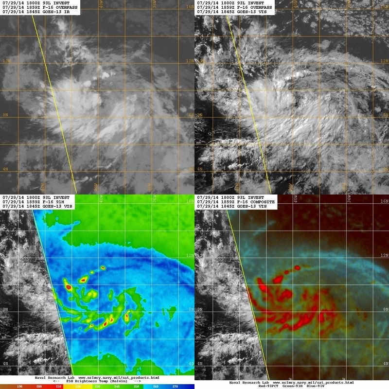
TROPICAL WEATHER OUTLOOK
NWS NATIONAL HURRICANE CENTER MIAMI FL
800 PM EDT TUE JUL 29 2014
For the North Atlantic...Caribbean Sea and the Gulf of Mexico:
Satellite images indicate that showers and thunderstorms associated
with an area of low pressure located about 1400 miles east of the
southern Windward Islands are currently limited. This system
remains well organized, however, and it could develop into a
tropical depression tonight or tomorrow while it moves westward
or west-northwestward near 15 mph.
* Formation chance through 48 hours...high...70 percent.
* Formation chance through 5 days...high...70 percent.
$$
Forecaster Beven
Users browsing this forum: No registered users and 14 guests


