
ATL: BERTHA - Post-Tropical - Discussion
Moderator: S2k Moderators
-
northjaxpro

- S2K Supporter

- Posts: 8900
- Joined: Mon Sep 27, 2010 11:21 am
- Location: Jacksonville, FL
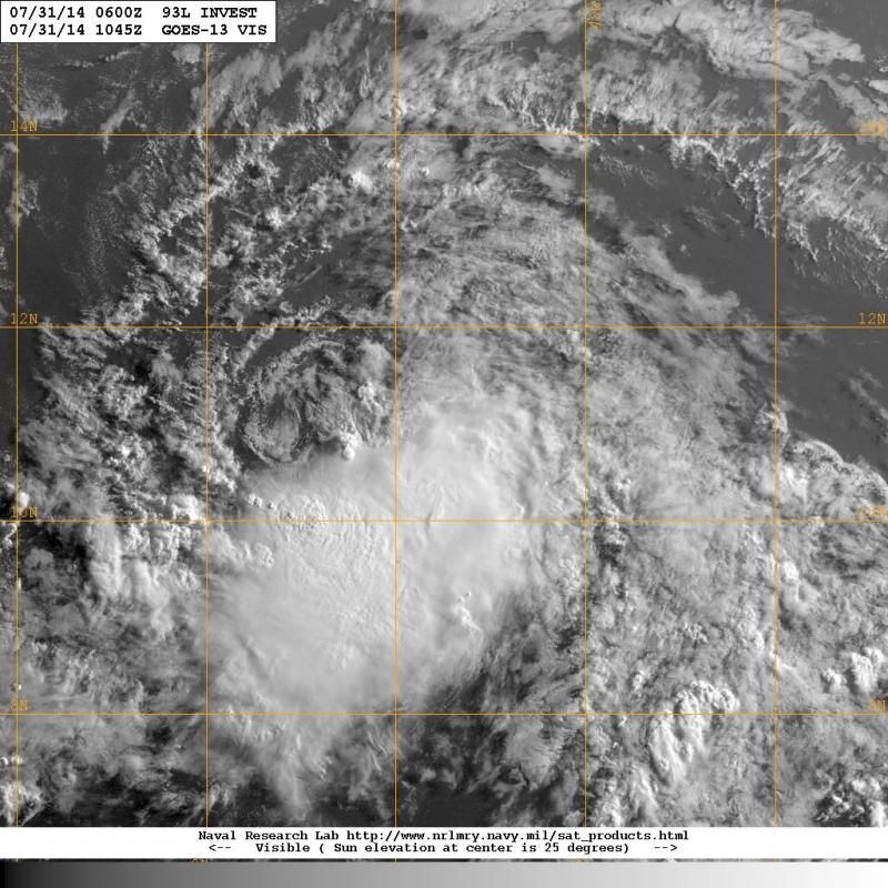
Very little change overnight. If convection doesn't get closer to the LLC during the day today, I can't see this system surviving. The ole' visit from Bones may not be too far off. We will find out as time progresses.
0 likes
NEVER, EVER SAY NEVER in the tropics and weather in general, and most importantly, with life itself!!
________________________________________________________________________________________
Fay 2008 Beryl 2012 Debby 2012 Colin 2016 Hermine 2016 Julia 2016 Matthew 2016 Irma 2017 Dorian 2019
________________________________________________________________________________________
Fay 2008 Beryl 2012 Debby 2012 Colin 2016 Hermine 2016 Julia 2016 Matthew 2016 Irma 2017 Dorian 2019
-
Syx6sic
- Tropical Depression

- Posts: 84
- Age: 41
- Joined: Wed Jun 05, 2013 12:11 pm
- Location: Virginia beach VA
000
ABNT20 KNHC 311131
TWOAT
TROPICAL WEATHER OUTLOOK
NWS NATIONAL HURRICANE CENTER MIAMI FL
800 AM EDT THU JUL 31 2014
For the North Atlantic...Caribbean Sea and the Gulf of Mexico:
A well-defined low pressure system located about 650 miles east of the southern Windward Islands has been producing organized shower and thunderstorm activity during the past several hours. If this activity persists, tropical depression or tropical storm advisories will be initiated later this morning. Interests in the Lesser Antilles should monitor the progress of this disturbance as it moves west-northwestward at 15 to 20 mph, and watches or warnings may be required for some of these islands later today. A Hurricane Hunter aircraft is scheduled to investigate the system this afternoon. * Formation chance through 48 hours...high...70 percent. * Formation chance through 5 days...high...70 percent.
$$ Forecaster Pasch
0 likes
Personal Forecast Disclaimer:
The posts in this forum are NOT official forecast and should not be used as such. They are just the opinion of the poster and may or may not be backed by sound meteorological data. They are NOT endorsed by any professional institution or storm2k.org. For official information, please refer to the NHC and NWS products.
The posts in this forum are NOT official forecast and should not be used as such. They are just the opinion of the poster and may or may not be backed by sound meteorological data. They are NOT endorsed by any professional institution or storm2k.org. For official information, please refer to the NHC and NWS products.
-
Blown Away

- S2K Supporter
- Posts: 10253
- Joined: Wed May 26, 2004 6:17 am
Re:
northjaxpro wrote:Very little change overnight. If convection doesn't get closer to the LLC during the day today, I can't see this system surviving. The ole' visit from Bones may not be too far off. We will find out as time progresses.
I kinda disagree, we've seen TD's and TS's where most of the LLC was exposed but convection firing in 1 quadrent... Just looking at the satellite now, 93L has alot going for it being just an Invest...
0 likes
Hurricane Eye Experience: David 79, Irene 99, Frances 04, Jeanne 04, Wilma 05… Hurricane Brush Experience: Andrew 92, Erin 95, Floyd 99, Matthew 16, Irma 17, Ian 22, Nicole 22…
-
hurricaneCW
- Category 5

- Posts: 1799
- Joined: Wed Mar 03, 2010 6:20 am
- Location: Toms River, NJ
Re: ATL: INVEST 93L - Discussion
Never fall asleep on a strong vigorous disturbance even if it may not look like much convectively because any favorable window and it could easily and quickly get its act together. At least some impact towards the islands is likely with a question mark after that.
0 likes
-
TheStormExpert
I'm surprised the NHC is making that much of a 20-30 kt swirl with two thunderstomrs on the southern boundary - guess they just choosing to err on the side of caution, though as the pro mets have said conditions are only getting more hostile as it moves westward into an area of strong shear...
0 likes
-
tolakram
- Admin

- Posts: 20186
- Age: 62
- Joined: Sun Aug 27, 2006 8:23 pm
- Location: Florence, KY (name is Mark)
Re: ATL: INVEST 93L - Discussion
live visible loop: http://wwwghcc.msfc.nasa.gov/cgi-bin/get-goes?satellite=GOES-E%20HURRICANE&lat=8&lon=-52&info=vis&zoom=1&width=1024&height=768&type=Animation&quality=92&palette=ir1.pal&numframes=5
Is the LLC opening up?
Is the LLC opening up?
0 likes
M a r k
- - - - -
Join us in chat: Storm2K Chatroom Invite. Android and IOS apps also available.
The posts in this forum are NOT official forecasts and should not be used as such. Posts are NOT endorsed by any professional institution or STORM2K.org. For official information and forecasts, please refer to NHC and NWS products.
-
Blown Away
- S2K Supporter
- Posts: 10253
- Joined: Wed May 26, 2004 6:17 am
Re: ATL: INVEST 93L - Discussion
JMHO, if 93L is moving closer to the 20mph mark and continues to be a shallow system mostly devoid of convection, I don't see 93L gaining the latitude at the rate forecasted by the global models... I wouldn't be surprised to to see the 0-72 hour path continue to shift west...
0 likes
Hurricane Eye Experience: David 79, Irene 99, Frances 04, Jeanne 04, Wilma 05… Hurricane Brush Experience: Andrew 92, Erin 95, Floyd 99, Matthew 16, Irma 17, Ian 22, Nicole 22…
-
Blown Away
- S2K Supporter
- Posts: 10253
- Joined: Wed May 26, 2004 6:17 am
Re: ATL: INVEST 93L - Discussion
000
ABNT20 KNHC 311131
TWOAT
TROPICAL WEATHER OUTLOOK
NWS NATIONAL HURRICANE CENTER MIAMI FL
800 AM EDT THU JUL 31 2014
For the North Atlantic...Caribbean Sea and the Gulf of Mexico:
A well-defined low pressure system located about 650 miles east of
the southern Windward Islands has been producing organized shower
and thunderstorm activity during the past several hours. If this
activity persists, tropical depression or tropical storm advisories
will be initiated later this morning. Interests in the Lesser
Antilles should monitor the progress of this disturbance as it moves
west-northwestward at 15 to 20 mph, and watches or warnings may be
required for some of these islands later today. A Hurricane
Hunter aircraft is scheduled to investigate the system this
afternoon.
* Formation chance through 48 hours...high...70 percent.
* Formation chance through 5 days...high...70 percent.
$$
Forecaster Pasch
0 likes
Hurricane Eye Experience: David 79, Irene 99, Frances 04, Jeanne 04, Wilma 05… Hurricane Brush Experience: Andrew 92, Erin 95, Floyd 99, Matthew 16, Irma 17, Ian 22, Nicole 22…
-
cycloneye

- Admin
- Posts: 149566
- Age: 69
- Joined: Thu Oct 10, 2002 10:54 am
- Location: San Juan, Puerto Rico
Re: ATL: INVEST 93L - Discussion
12z Best Track:
AL, 93, 2014073112, , BEST, 0, 110N, 514W, 30, 1010, LO
AL, 93, 2014073112, , BEST, 0, 110N, 514W, 30, 1010, LO
0 likes
Visit the Caribbean-Central America Weather Thread where you can find at first post web cams,radars
and observations from Caribbean basin members Click Here
and observations from Caribbean basin members Click Here
-
northjaxpro
- S2K Supporter
- Posts: 8900
- Joined: Mon Sep 27, 2010 11:21 am
- Location: Jacksonville, FL
Re: Re:
Blown Away wrote:northjaxpro wrote:Very little change overnight. If convection doesn't get closer to the LLC during the day today, I can't see this system surviving. The ole' visit from Bones may not be too far off. We will find out as time progresses.
I kinda disagree, we've seen TD's and TS's where most of the LLC was exposed but convection firing in 1 quadrent... Just looking at the satellite now, 93L has alot going for it being just an Invest...
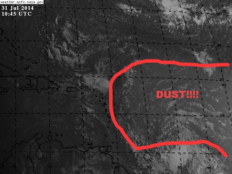
This is true. However, given the amount of dry air already present, especially in the north and northwestern quadrant, 93L faces an uphill battle to scour out. Convection has to get close to the LLC quickly for the vortex to maintain itself. Conditions overall just are not good out there , and even if 93L can survive today, not sure if the system can maintain the next 48 hours.
0 likes
NEVER, EVER SAY NEVER in the tropics and weather in general, and most importantly, with life itself!!
________________________________________________________________________________________
Fay 2008 Beryl 2012 Debby 2012 Colin 2016 Hermine 2016 Julia 2016 Matthew 2016 Irma 2017 Dorian 2019
________________________________________________________________________________________
Fay 2008 Beryl 2012 Debby 2012 Colin 2016 Hermine 2016 Julia 2016 Matthew 2016 Irma 2017 Dorian 2019

Re: ATL: INVEST 93L - Discussion
I think aircraft will find TS this afternoon. ..my opinion only
0 likes
-
Blown Away
- S2K Supporter
- Posts: 10253
- Joined: Wed May 26, 2004 6:17 am
Re:
NDG wrote:Based on the 12z Best Track position, it is calculated that 93L is now tracking at 19.5 mph in average over the last 6 hrs, so definitely picking up some speed.
Yep, I bet the 0-72 hour track continues to shift West because of the forward speed... No signs of a hard NW turn coming... JMHO
0 likes
Hurricane Eye Experience: David 79, Irene 99, Frances 04, Jeanne 04, Wilma 05… Hurricane Brush Experience: Andrew 92, Erin 95, Floyd 99, Matthew 16, Irma 17, Ian 22, Nicole 22…


-
SouthDadeFish

- Professional-Met

- Posts: 2836
- Joined: Thu Sep 23, 2010 2:54 pm
- Location: Miami, FL
- Contact:
Who is online
Users browsing this forum: No registered users and 14 guests