ATL: BERTHA - Post-Tropical - Discussion
Moderator: S2k Moderators

Re: ATL: BERTHA - Tropical Storm - Discussion
She really needs to start gaining some latitude if she's gonna clear DR.
0 likes

-
supercane4867
- Category 5

- Posts: 4966
- Joined: Wed Nov 14, 2012 10:43 am
Re: ATL: BERTHA - Tropical Storm - Discussion
PR radar loop with the circulation barely visible

0 likes

The vortex looks better defined than it did a few hours ago, looks like it might be trying to close off again, as there is a more N-NNE movement to the storms SE of the center rather than NW movement.
0 likes
The above post is not official and should not be used as such. It is the opinion of the poster and may or may not be backed by sound meteorological data. It is not endorsed by any professional institution or storm2k.org. For official information, please refer to the NHC and NWS products.
-
Equilibrium
Dont believe at any point this has been a open wave since the low first closed off and its not now. I did see a mention that it could become a open wave as a alternative senario in NHCA advisories over 24 hours ago i guess thats why a few of you are sticking to that conclusion.
The posts in this forum are NOT official forecast and should not be used as such. They are just the opinion of the poster and may or may not be backed by sound meteorological data. They are NOT endorsed by any professional institution or storm2k.org. For official information, please refer to the NHC and NWS products
The posts in this forum are NOT official forecast and should not be used as such. They are just the opinion of the poster and may or may not be backed by sound meteorological data. They are NOT endorsed by any professional institution or storm2k.org. For official information, please refer to the NHC and NWS products
0 likes

Re: ATL: BERTHA - Tropical Storm - Discussion
The recon will be flying in from Curacao so most likely the first quadrant that it will be sampling will be SW quadrant which will help in seeing if it is still closed or not. Ever since yesterday morning it has been going back and forth in being completely closed.
Last edited by NDG on Sat Aug 02, 2014 5:27 am, edited 1 time in total.
0 likes
Re: ATL: BERTHA - Tropical Storm - Discussion
What you mean barely visible? That's a fairly good circulation, as good as it has been for Bertha.
0 likes
-
Equilibrium
The radar image posted above is is usually what is seen on a pre- deepening low as it starts to begin to tighten up.
The posts in this forum are NOT official forecast and should not be used as such. They are just the opinion of the poster and may or may not be backed by sound meteorological data. They are NOT endorsed by any professional institution or storm2k.org. For official information, please refer to the NHC and NWS products
The posts in this forum are NOT official forecast and should not be used as such. They are just the opinion of the poster and may or may not be backed by sound meteorological data. They are NOT endorsed by any professional institution or storm2k.org. For official information, please refer to the NHC and NWS products
0 likes
Re: ATL: BERTHA - Tropical Storm - Discussion
Just my opinion, but on its current track it appears that Bertha will cross the Dominican Republic which would favor weakening or even dissipation..
Frank
Frank
0 likes
-
tolakram
- Admin

- Posts: 20186
- Age: 62
- Joined: Sun Aug 27, 2006 8:23 pm
- Location: Florence, KY (name is Mark)
Re: ATL: BERTHA - Tropical Storm - Discussion
0 likes
M a r k
- - - - -
Join us in chat: Storm2K Chatroom Invite. Android and IOS apps also available.
The posts in this forum are NOT official forecasts and should not be used as such. Posts are NOT endorsed by any professional institution or STORM2K.org. For official information and forecasts, please refer to NHC and NWS products.
-
tolakram
- Admin
- Posts: 20186
- Age: 62
- Joined: Sun Aug 27, 2006 8:23 pm
- Location: Florence, KY (name is Mark)
Re: ATL: BERTHA - Tropical Storm - Discussion
saved radar loop

0 likes
M a r k
- - - - -
Join us in chat: Storm2K Chatroom Invite. Android and IOS apps also available.
The posts in this forum are NOT official forecasts and should not be used as such. Posts are NOT endorsed by any professional institution or STORM2K.org. For official information and forecasts, please refer to NHC and NWS products.
- - - - -
Join us in chat: Storm2K Chatroom Invite. Android and IOS apps also available.
The posts in this forum are NOT official forecasts and should not be used as such. Posts are NOT endorsed by any professional institution or STORM2K.org. For official information and forecasts, please refer to NHC and NWS products.


Re: ATL: BERTHA - Tropical Storm - Discussion
Frank2 wrote:Just my opinion, but on its current track it appears that Bertha will cross the Dominican Republic which would favor weakening or even dissipation..
Frank
It does look like it may cross over more of the Dominican Republic and I know sometimes the weaker storms seems to survive the cross over and regenerate once it's back over the water again.
0 likes
Re: ATL: BERTHA - Tropical Storm - Discussion
Frank2 wrote:Just my opinion, but on its current track it appears that Bertha will cross the Dominican Republic which would favor weakening or even dissipation..
Frank
Yeap, she better start moving almost NW pretty soon to make the Mona Passage otherwise she will be going through the DR.
0 likes
-
gatorcane

- S2K Supporter

- Posts: 23708
- Age: 48
- Joined: Sun Mar 13, 2005 3:54 pm
- Location: Boca Raton, FL
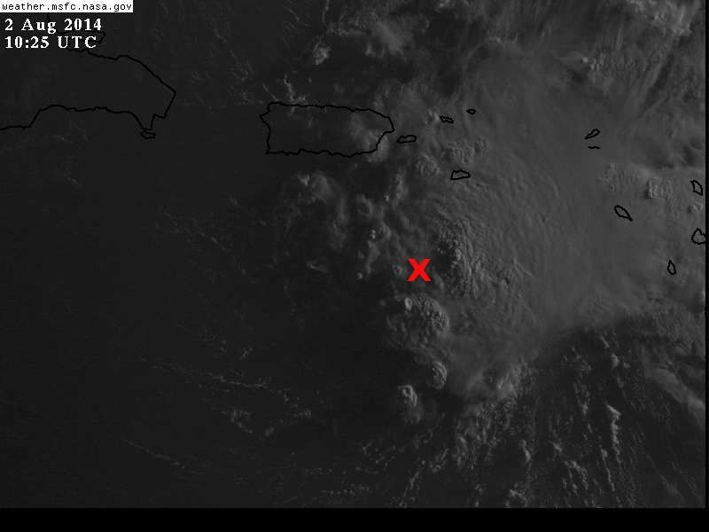
Looking at the latest vis loops this morning, it looks to me like Bertha is tracking quite a bit south of the next NHC forecast point.
Bertha is also racing WNW.
Graphic as how I see it:

The posts in this forum are NOT official forecast and should not be used as such. They are just the opinion of the poster and may or may not be backed by sound meteorological data. They are NOT endorsed by any professional institution or storm2k.org. For official information, please refer to the NHC and NWS products.
Bertha is also racing WNW.
Graphic as how I see it:
The posts in this forum are NOT official forecast and should not be used as such. They are just the opinion of the poster and may or may not be backed by sound meteorological data. They are NOT endorsed by any professional institution or storm2k.org. For official information, please refer to the NHC and NWS products.
Last edited by gatorcane on Sat Aug 02, 2014 7:37 am, edited 1 time in total.
0 likes
-
jlauderdal
- S2K Supporter
- Posts: 7240
- Joined: Wed May 19, 2004 5:46 am
- Location: NE Fort Lauderdale
- Contact:

-
Gustywind

- Category 5
- Posts: 12334
- Joined: Mon Sep 03, 2007 7:29 am
- Location: Baie-Mahault, GUADELOUPE
Be safe and dry Cycloneye,hoping that you have some big showers to erase a little bit the extreme severe drought. 
BULLETIN
TROPICAL STORM BERTHA ADVISORY NUMBER 6
NWS NATIONAL HURRICANE CENTER MIAMI FL AL032014
500 AM AST SAT AUG 02 2014
...BERTHA MOVING RAPIDLY ACROSS THE NORTHEASTERN CARIBBEAN SEA...
...HEAVY SQUALLS APPROACHING PUERTO RICO AND THE VIRGIN ISLANDS...
SUMMARY OF 500 AM AST...0900 UTC...INFORMATION
----------------------------------------------
LOCATION...16.3N 64.9W
ABOUT 95 MI...155 KM S OF ST. CROIX
ABOUT 165 MI...265 KM SSE OF SAN JUAN PUERTO RICO
MAXIMUM SUSTAINED WINDS...50 MPH...85 KM/H
PRESENT MOVEMENT...WNW OR 295 DEGREES AT 22 MPH...35 KM/H
MINIMUM CENTRAL PRESSURE...1008 MB...29.77 INCHES
0 likes
Re:
gatorcane wrote:Looking at the latest vis loops this morning, it looks to me like Bertha is tracking quite a bit south of the next NHC forecast point.
Bertha is also racing WNW.
Graphic as how I see it:
The posts in this forum are NOT official forecast and should not be used as such. They are just the opinion of the poster and may or may not be backed by sound meteorological data. They are NOT endorsed by any professional institution or storm2k.org. For official information, please refer to the NHC and NWS products.
In that graphic it does appear to be south of the forecasted track. I know sometime tomorrow the NHC is expecting a more NW turn, but it sure is moving fast. I wonder if the track will be adjusted to left a little.
0 likes
Who is online
Users browsing this forum: No registered users and 14 guests