
ATL: CRISTOBAL - Post-Tropical - Discussion
Moderator: S2k Moderators
-
deltadog03

- Professional-Met

- Posts: 3580
- Joined: Tue Jul 05, 2005 6:16 pm
- Location: Macon, GA
-
Kingarabian

- S2K Supporter

- Posts: 16359
- Joined: Sat Aug 08, 2009 3:06 am
- Location: Honolulu, Hawaii
Re: ATL: INVEST 96L - Discussion
deltadog03 wrote:http://tropic.ssec.wisc.edu/real-time/atlantic/winds/wg8dlm1.GIF
Looks like it has to get going soon if it wants to be picked up.
0 likes
RIP Kobe Bryant
-
PTrackerLA

- Category 5

- Posts: 5281
- Age: 42
- Joined: Thu Oct 10, 2002 8:40 pm
- Location: Lafayette, LA
-
tropicwatch

- Category 5
- Posts: 3426
- Age: 62
- Joined: Sat Jun 02, 2007 10:01 am
- Location: The Villages, Florida
- Contact:
Re: ATL: INVEST 96L - Discussion
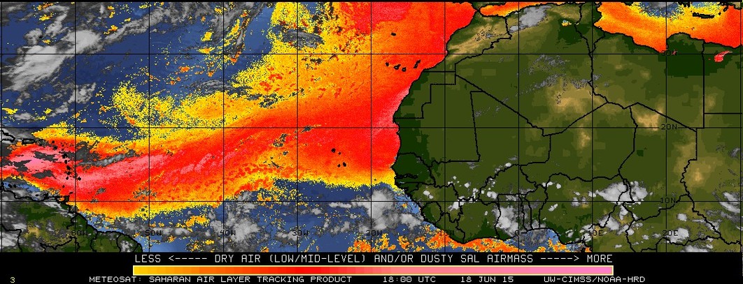
Well the SAL has diminished significantly, now the shear in front of it needs to subside.
0 likes
Tropicwatch
Agnes 72', Eloise 75, Elena 85', Kate 85', Charley 86', Florence 88', Beryl 94', Dean 95', Erin 95', Opal 95', Earl 98', Georges 98', Ivan 2004', Arlene 2005', Dennis 2005', Ida 2009' Debby 2012' Irma 2017' Michael 2018'
Agnes 72', Eloise 75, Elena 85', Kate 85', Charley 86', Florence 88', Beryl 94', Dean 95', Erin 95', Opal 95', Earl 98', Georges 98', Ivan 2004', Arlene 2005', Dennis 2005', Ida 2009' Debby 2012' Irma 2017' Michael 2018'
-
cycloneye

- Admin

- Posts: 149429
- Age: 69
- Joined: Thu Oct 10, 2002 10:54 am
- Location: San Juan, Puerto Rico
Re: ATL: INVEST 96L - Discussion
My eyes see 12.7N-52.5W.
The posts in this forum are NOT official forecast and should not be used as such. They are just the opinion of the poster and may or may not be backed by sound meteorological data. They are NOT endorsed by any professional institution or storm2k.org. For official information, please refer to the NHC and NWS products.
The posts in this forum are NOT official forecast and should not be used as such. They are just the opinion of the poster and may or may not be backed by sound meteorological data. They are NOT endorsed by any professional institution or storm2k.org. For official information, please refer to the NHC and NWS products.
0 likes
Visit the Caribbean-Central America Weather Thread where you can find at first post web cams,radars
and observations from Caribbean basin members Click Here
and observations from Caribbean basin members Click Here
-
northjaxpro

- S2K Supporter
- Posts: 8900
- Joined: Mon Sep 27, 2010 11:21 am
- Location: Jacksonville, FL
Re: ATL: INVEST 96L - Discussion
cycloneye wrote:My eyes see 12.7N-52.5W.
The posts in this forum are NOT official forecast and should not be used as such. They are just the opinion of the poster and may or may not be backed by sound meteorological data. They are NOT endorsed by any professional institution or storm2k.org. For official information, please refer to the NHC and NWS products.
That's about right. It is definitely gaining forward speed in my view.
0 likes
NEVER, EVER SAY NEVER in the tropics and weather in general, and most importantly, with life itself!!
________________________________________________________________________________________
Fay 2008 Beryl 2012 Debby 2012 Colin 2016 Hermine 2016 Julia 2016 Matthew 2016 Irma 2017 Dorian 2019
________________________________________________________________________________________
Fay 2008 Beryl 2012 Debby 2012 Colin 2016 Hermine 2016 Julia 2016 Matthew 2016 Irma 2017 Dorian 2019
-
Hurricane Andrew

- S2K Supporter
- Posts: 1891
- Age: 27
- Joined: Sun May 23, 2010 2:53 pm
- Location: KS
The posts in this forum are NOT official forecast and should not be used as such. They are just the opinion of the poster and may or may not be backed by sound meteorological data. They are NOT endorsed by any professional institution or storm2k.org. For official information, please refer to the NHC and NWS products.
IMO, would go with 70/90 at 8pm, and if organization continues, 80/90 tomorrow morning.
IMO, would go with 70/90 at 8pm, and if organization continues, 80/90 tomorrow morning.
0 likes
The Enthusiast
NREMT-AEMT, WX nerd
Irene '11, Sandy '12, Irma '17 (SAR)
"Hard to think we were born to live this way..." -Wage War
-
TheStormExpert
Nice very informative new video discussion by Tropical Tidbits Levi Cowan. Mentions why we should not put too much weight on the models just yet until 96L consolidates and forms.
http://www.tropicaltidbits.com/blog/2014/08/20/invest-96l-real-meteorology-versus-hype-and-public-perception/
http://www.tropicaltidbits.com/blog/2014/08/20/invest-96l-real-meteorology-versus-hype-and-public-perception/
Last edited by TheStormExpert on Wed Aug 20, 2014 5:09 pm, edited 2 times in total.
0 likes

Re:
PTrackerLA wrote:Hard to see how this doesn't pass south of PR given the steering flow but I guess we'll see. Looks like a strong burst of convection right near the "center" as the sun sets.
Once it detaches from the monsoon trough and spins up it could gain latitude fairly quickly. A slow journey over Hispaniola and the spine of Cuba as a weakening tropical storm is probably too much to hope for. Looks like the TUTT that was north of Puerto Rico is receding west meaning a more favorable environment for development could be ahead.
There have been some low clouds dipping south ahead of the circulation center looks like it might cross 55W near 13N.
Last edited by Nimbus on Wed Aug 20, 2014 5:16 pm, edited 1 time in total.
0 likes
-
SFLcane

- S2K Supporter
- Posts: 10281
- Age: 48
- Joined: Sat Jun 05, 2010 1:44 pm
- Location: Lake Worth Florida
Re:
Hurricane Andrew wrote:The posts in this forum are NOT official forecast and should not be used as such. They are just the opinion of the poster and may or may not be backed by sound meteorological data. They are NOT endorsed by any professional institution or storm2k.org. For official information, please refer to the NHC and NWS products.
IMO, would go with 70/90 at 8pm, and if organization continues, 80/90 tomorrow morning.
Na... system has changed little in organization.
0 likes
-
TheStormExpert
Re: Re:
SFLcane wrote:Hurricane Andrew wrote:The posts in this forum are NOT official forecast and should not be used as such. They are just the opinion of the poster and may or may not be backed by sound meteorological data. They are NOT endorsed by any professional institution or storm2k.org. For official information, please refer to the NHC and NWS products.
IMO, would go with 70/90 at 8pm, and if organization continues, 80/90 tomorrow morning.
Na... system has changed little in organization.
50/70% @ 8pm seems more likely.
0 likes
-
Evil Jeremy

- S2K Supporter
- Posts: 5463
- Age: 32
- Joined: Mon Apr 10, 2006 2:10 pm
- Location: Los Angeles, CA
Re: ATL: INVEST 96L - Discussion
It's been a while since Florida has seen a legit threat. Looking forward to the 8pm TWO, and the start of a week of sleepless nights.
0 likes
Frances 04 / Jeanne 04 / Katrina 05 / Wilma 05 / Fay 08 / Debby 12 / Andrea 13 / Colin 16 / Hermine 16 / Matthew 16 / Irma 17
-
northjaxpro
- S2K Supporter
- Posts: 8900
- Joined: Mon Sep 27, 2010 11:21 am
- Location: Jacksonville, FL
Re: ATL: INVEST 96L - Discussion
For really the first time I am seeing convection starting to funnel in toward the developing COC on satellite imagery. If you observe closely, to my eyes, you are beginning to see some curvature to the structure of 96L now. I think this system is really beginning to get its act together now. Just an observation.
-____________________
Personal Forecast Disclaimer:
The posts in this forum are NOT official forecast and should not be used as such. They are just the opinion of the poster. For official information, please refer to the NHC and NWS products
-____________________
Personal Forecast Disclaimer:
The posts in this forum are NOT official forecast and should not be used as such. They are just the opinion of the poster. For official information, please refer to the NHC and NWS products
0 likes
NEVER, EVER SAY NEVER in the tropics and weather in general, and most importantly, with life itself!!
________________________________________________________________________________________
Fay 2008 Beryl 2012 Debby 2012 Colin 2016 Hermine 2016 Julia 2016 Matthew 2016 Irma 2017 Dorian 2019
________________________________________________________________________________________
Fay 2008 Beryl 2012 Debby 2012 Colin 2016 Hermine 2016 Julia 2016 Matthew 2016 Irma 2017 Dorian 2019

Re: Re:
Nimbus wrote:Once it detaches from the monsoon trough and spins up it could gain latitude fairly quickly. A slow journey over Hispaniola and the spine of Cuba as a weakening tropical storm is probably too much to hope for. Looks like the TUTT that was north of Puerto Rico is receding west meaning a more favorable environment for development could be ahead.
I'm not sure why that outcome would be "hoped for" as that's all we've seen over the last 5 years of this type of track nonsense
0 likes
-
cycloneye
- Admin
- Posts: 149429
- Age: 69
- Joined: Thu Oct 10, 2002 10:54 am
- Location: San Juan, Puerto Rico
Re:
TheStormExpert wrote:Nice very informative new video discussion by Tropical Tidbits Levi Cowan. Mentions why we should not put too much weight on the models just yet until 96L consolidates and forms.
http://www.tropicaltidbits.com/blog/2014/08/20/invest-96l-real-meteorology-versus-hype-and-public-perception/
He explains in a very simple way all the factors.A great one.
0 likes
Visit the Caribbean-Central America Weather Thread where you can find at first post web cams,radars
and observations from Caribbean basin members Click Here
and observations from Caribbean basin members Click Here
-
HurricaneTracker2031
- Tropical Storm

- Posts: 248
- Age: 26
- Joined: Fri Jul 19, 2013 7:20 pm
- Location: Pembroke Pines, FL, USA
- Contact:
Re: ATL: INVEST 96L - Discussion
96L beginning to get its act together and this may be a legit FLA threat and everyone should monitor this system closely...

Synopsis for 96L and other systems: http://goo.gl/9WK2bq
Personal Forecast Disclaimer:
The posts in this forum are NOT official forecast and should not be used as such. They are just the opinion of the poster and may or may not be backed by sound meteorological data. They are NOT endorsed by any professional institution or storm2k.org. For official information, please refer to the NHC and NWS products.
0 likes
SHORT VERSION OF DISCLAIMER: THIS SITE LINK BELOW IS NOT AN OFFICIAL FORECASTING OFFICE AND SHOULD NOT BE USED TO MAKE ANY EMERGENCY DECISIONS....
http://www.macstropicalweather.weebly.com
http://www.macstropicalweather.weebly.com
-
redneckweather
- Tropical Wave

- Posts: 5
- Joined: Tue Jan 04, 2011 1:43 pm
Re: ATL: INVEST 96L - Discussion
HurricaneTracker2031 wrote:96L beginning to get its act together and this may be a legit FLA threat and everyone should monitor this system closely...
Personal Forecast Disclaimer:
The posts in this forum are NOT official forecast and should not be used as such. They are just the opinion of the poster and may or may not be backed by sound meteorological data. They are NOT endorsed by any professional institution or storm2k.org. For official information, please refer to the NHC and NWS products.
And this may be a legit nothing. Dude, settle down. Let's get a LEGIT COC before you start evacuating the entire state of Florida.
0 likes
-
Evil Jeremy
- S2K Supporter
- Posts: 5463
- Age: 32
- Joined: Mon Apr 10, 2006 2:10 pm
- Location: Los Angeles, CA
Re: ATL: INVEST 96L - Discussion
redneckweather wrote:HurricaneTracker2031 wrote:96L beginning to get its act together and this may be a legit FLA threat and everyone should monitor this system closely...
Personal Forecast Disclaimer:
The posts in this forum are NOT official forecast and should not be used as such. They are just the opinion of the poster and may or may not be backed by sound meteorological data. They are NOT endorsed by any professional institution or storm2k.org. For official information, please refer to the NHC and NWS products.
And this may be a legit nothing. Dude, settle down. Let's get a LEGIT COC before you start evacuating the entire state of Florida.
Nothing HurricaneTracker2031 said was out of line. This is getting it's act together, it may be a Florida threat, and everyone should pay attention. All 3 of those statements are valid.
0 likes
Frances 04 / Jeanne 04 / Katrina 05 / Wilma 05 / Fay 08 / Debby 12 / Andrea 13 / Colin 16 / Hermine 16 / Matthew 16 / Irma 17
-
Janie2006

- Category 5
- Posts: 1329
- Joined: Mon Sep 18, 2006 3:28 pm
- Location: coastal Ms aka home of the hurricanes
Re: ATL: INVEST 96L - Discussion
I'm waiting for 96L to get its act together before I start overly concerning myself with model output. The larger synoptic trends are interesting, but any attempt at long range prognostication is really a case of tilting at those infamous windmills. Be patient, grasshopper. 
0 likes
Who is online
Users browsing this forum: No registered users and 14 guests