ATL: CRISTOBAL - Post-Tropical - Discussion
Moderator: S2k Moderators
-
HURRICANELONNY
- Category 5

- Posts: 1392
- Joined: Wed May 07, 2003 6:48 am
- Location: HOLLYWOOD.FL
-
wxman57

- Moderator-Pro Met

- Posts: 23174
- Age: 68
- Joined: Sat Jun 21, 2003 8:06 pm
- Location: Houston, TX (southwest)
Re: ATL: INVEST 96L - Discussion
Surface obs say no LLC north of PR, but definitely no LLC south of PR either. Just a wave axis moving through the region.

0 likes
-
ScottNAtlanta

- Category 5
- Posts: 2535
- Joined: Sat May 25, 2013 3:11 pm
- Location: Atlanta, GA
Re: ATL: INVEST 96L - Discussion
Bastardi is now talking about the possibility of a 2 storm solution similar to Gabriele/Humberto of 2007.
0 likes
The posts in this forum are NOT official forecast and should not be used as such. They are just the opinion of the poster and may or may not be backed by sound meteorological data. They are NOT endorsed by any professional institution or storm2k.org. For official information, please refer to the NHC and NWS products.
-
bamajammer4eva
- Category 4

- Posts: 907
- Joined: Sun Apr 18, 2010 3:21 am
- Location: Ozark, AL
Re: ATL: INVEST 96L - Discussion
ScottNAtlanta wrote:Bastardi is now talking about the possibility of a 2 storm solution similar to Gabriele/Humberto of 2007.
Also he just tweeted that the circulation center is developing but made no mention of which one north or south.
0 likes
-
wxman57
- Moderator-Pro Met
- Posts: 23174
- Age: 68
- Joined: Sat Jun 21, 2003 8:06 pm
- Location: Houston, TX (southwest)
Re: ATL: INVEST 96L - Discussion
I think he's seeing things. Can't find anything in the surface obs or satellite imagery to suggest an LLC is forming.
0 likes
-
stormlover2013
-
ScottNAtlanta
- Category 5
- Posts: 2535
- Joined: Sat May 25, 2013 3:11 pm
- Location: Atlanta, GA
Re: ATL: INVEST 96L - Discussion
stormlover2013 wrote:I don't see where he said 2 storms are are forming
It was on his video this morning on the paid site. He said he thinks the southern half will head west and is a threat to develop in the gulf...not right now.
Perhaps Hispaniola will slice it into 2 pieces like a knife
Last edited by ScottNAtlanta on Fri Aug 22, 2014 9:38 am, edited 2 times in total.
0 likes
The posts in this forum are NOT official forecast and should not be used as such. They are just the opinion of the poster and may or may not be backed by sound meteorological data. They are NOT endorsed by any professional institution or storm2k.org. For official information, please refer to the NHC and NWS products.
-
ScottNAtlanta
- Category 5
- Posts: 2535
- Joined: Sat May 25, 2013 3:11 pm
- Location: Atlanta, GA
Re: ATL: INVEST 96L - Discussion
Most of the 850 vorticity is south of PR right now
0 likes
The posts in this forum are NOT official forecast and should not be used as such. They are just the opinion of the poster and may or may not be backed by sound meteorological data. They are NOT endorsed by any professional institution or storm2k.org. For official information, please refer to the NHC and NWS products.
-
Janie2006

- Category 5
- Posts: 1329
- Joined: Mon Sep 18, 2006 3:28 pm
- Location: coastal Ms aka home of the hurricanes
Re: ATL: INVEST 96L - Discussion
Well, if the southern half of the wave axis (or any part of this wave, for that matter) is developing it sure is doing it Mrs. Butterworth style...slow, syrupy, and messy.
0 likes
-
Tyler Penland
- Tropical Depression

- Posts: 63
- Joined: Fri Aug 19, 2011 12:32 pm
- Location: Blowing Rock, NC
Re: ATL: INVEST 96L - Discussion
wxman57 wrote:I think he's seeing things. Can't find anything in the surface obs or satellite imagery to suggest an LLC is forming.
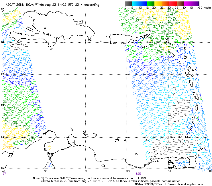
ASCAT caught the far eastern portions of the wave. Nothing apparent on the back side.
0 likes
****The above is NOT AN OFFICIAL FORECAST. I am in no way affiliated with the NWS or storm2k, and most likely don't share their opinion. Please refer to NWS/NHC products for official advisories/warnings/forecasts.****
But if you insist, trust me, I'm a physicist.
But if you insist, trust me, I'm a physicist.
-
wxman57
- Moderator-Pro Met
- Posts: 23174
- Age: 68
- Joined: Sat Jun 21, 2003 8:06 pm
- Location: Houston, TX (southwest)
Re: ATL: INVEST 96L - Discussion
Tyler Penland wrote:
ASCAT caught the far eastern portions of the wave. Nothing apparent on the back side.
http://i742.photobucket.com/albums/xx70 ... 39a028.png
That image is from 8:56pm CDT yesterday (see the UTC time stamp in purple under the image). The entire wave was captured. I highlighted its approximate location on the ASCAT image:

0 likes
-
Tyler Penland
- Tropical Depression
- Posts: 63
- Joined: Fri Aug 19, 2011 12:32 pm
- Location: Blowing Rock, NC
Re: ATL: INVEST 96L - Discussion
wxman57 wrote:Tyler Penland wrote:
ASCAT caught the far eastern portions of the wave. Nothing apparent on the back side.
http://i742.photobucket.com/albums/xx70 ... 39a028.png
That image is from 8:56pm CDT yesterday (see the UTC time stamp in purple under the image). The entire wave was captured. I highlighted its approximate location on the ASCAT image:
Ah crap. I was looking at the timestamp at the top which change. Oops.
Thanks for the correction.
0 likes
****The above is NOT AN OFFICIAL FORECAST. I am in no way affiliated with the NWS or storm2k, and most likely don't share their opinion. Please refer to NWS/NHC products for official advisories/warnings/forecasts.****
But if you insist, trust me, I'm a physicist.
But if you insist, trust me, I'm a physicist.
The wave axis seems to have become negatively tilted and if there's any cyclogenesis it looks to be E-NE of Puerto Rico...
http://www.ssd.noaa.gov/goes/east/tatl/vis-animated.gif
http://www.ssd.noaa.gov/goes/east/tatl/vis-animated.gif
0 likes
-
cycloneye

- Admin

- Posts: 149433
- Age: 69
- Joined: Thu Oct 10, 2002 10:54 am
- Location: San Juan, Puerto Rico
Re: ATL: INVEST 96L - Discussion
Recon is going this afternoon with plane departing St Croix at 12:30 PM EDT.
0 likes
Visit the Caribbean-Central America Weather Thread where you can find at first post web cams,radars
and observations from Caribbean basin members Click Here
and observations from Caribbean basin members Click Here

Re: ATL: INVEST 96L - Discussion
Carrying perhaps the most convection it's ever had right there.
0 likes
-
tropicwatch

- Category 5
- Posts: 3426
- Age: 62
- Joined: Sat Jun 02, 2007 10:01 am
- Location: The Villages, Florida
- Contact:
Possible surface low trying to form south west of Puerto Rico.
http://earth.nullschool.net/#current/wi ... ,13.25,674
http://earth.nullschool.net/#current/wi ... ,13.25,674
0 likes
Tropicwatch
Agnes 72', Eloise 75, Elena 85', Kate 85', Charley 86', Florence 88', Beryl 94', Dean 95', Erin 95', Opal 95', Earl 98', Georges 98', Ivan 2004', Arlene 2005', Dennis 2005', Ida 2009' Debby 2012' Irma 2017' Michael 2018'
Agnes 72', Eloise 75, Elena 85', Kate 85', Charley 86', Florence 88', Beryl 94', Dean 95', Erin 95', Opal 95', Earl 98', Georges 98', Ivan 2004', Arlene 2005', Dennis 2005', Ida 2009' Debby 2012' Irma 2017' Michael 2018'
-
wxman57
- Moderator-Pro Met
- Posts: 23174
- Age: 68
- Joined: Sat Jun 21, 2003 8:06 pm
- Location: Houston, TX (southwest)
Re: ATL: INVEST 96L - Discussion
I don't see anything for recon to fly into this afternoon. Perhaps they'll cancel? No development today.
0 likes
-
hectopascal
Re:
Alyono wrote:could still be a very small LLC, like the plane found yesterday. West winds could extend maybe 15-20 miles south of a center

Think so too blew up this snap shot looks like the llcc small RED dot.
http://cimss.ssec.wisc.edu/goes_r/provi ... ation.html
22/8 15-15 UTC
The posts in this forum are NOT official forecast and should not be used as such. They are just the opinion of the poster and may or may not be backed by sound meteorological data. They are NOT endorsed by any professional institution or storm2k.org. For official information, please refer to the NHC and NWS products
Last edited by hectopascal on Fri Aug 22, 2014 10:51 am, edited 1 time in total.
0 likes
-
SouthDadeFish

- Professional-Met

- Posts: 2835
- Joined: Thu Sep 23, 2010 2:54 pm
- Location: Miami, FL
- Contact:
Who is online
Users browsing this forum: No registered users and 16 guests