Global model runs discussion
Moderator: S2k Moderators
-
floridasun78
- Category 5

- Posts: 3755
- Joined: Sun May 17, 2009 10:16 pm
- Location: miami fl
- SFLcane
- S2K Supporter

- Posts: 10281
- Age: 48
- Joined: Sat Jun 05, 2010 1:44 pm
- Location: Lake Worth Florida
Re: Global Model Runs Discussion
Guess its texas turn now..18z run looks heading W after clipping yucatan.
0 likes
-
HURRICANELONNY
- Category 5

- Posts: 1390
- Joined: Wed May 07, 2003 6:48 am
- Location: HOLLYWOOD.FL
I don't know why i'm even responding to this because its the GFS but dont see Texas on the 12z run at all. Just showing it clipping the Yucatan. 
http://moe.met.fsu.edu/cgi-bin/gfstc2.c ... =Animation
http://moe.met.fsu.edu/cgi-bin/gfstc2.c ... =Animation
0 likes
hurricanelonny
- tropicwatch
- Category 5

- Posts: 3426
- Age: 62
- Joined: Sat Jun 02, 2007 10:01 am
- Location: Panama City Florida
- Contact:
Well at least it is something to look at even though it might just be a ghost storm. It is October ya know. 
0 likes
Tropicwatch
Agnes 72', Eloise 75, Elena 85', Kate 85', Charley 86', Florence 88', Beryl 94', Dean 95', Erin 95', Opal 95', Earl 98', Georges 98', Ivan 2004', Arlene 2005', Dennis 2005', Ida 2009' Debby 2012' Irma 2017' Michael 2018'
Agnes 72', Eloise 75, Elena 85', Kate 85', Charley 86', Florence 88', Beryl 94', Dean 95', Erin 95', Opal 95', Earl 98', Georges 98', Ivan 2004', Arlene 2005', Dennis 2005', Ida 2009' Debby 2012' Irma 2017' Michael 2018'
- PTrackerLA
- Category 5

- Posts: 5281
- Age: 42
- Joined: Thu Oct 10, 2002 8:40 pm
- Location: Lafayette, LA
Re: Global Model Runs Discussion
18z GFS crazy track in long range but still insisting we see a tropical depression by the end of the work week. We'll see.
0 likes
- tropicwatch
- Category 5

- Posts: 3426
- Age: 62
- Joined: Sat Jun 02, 2007 10:01 am
- Location: Panama City Florida
- Contact:
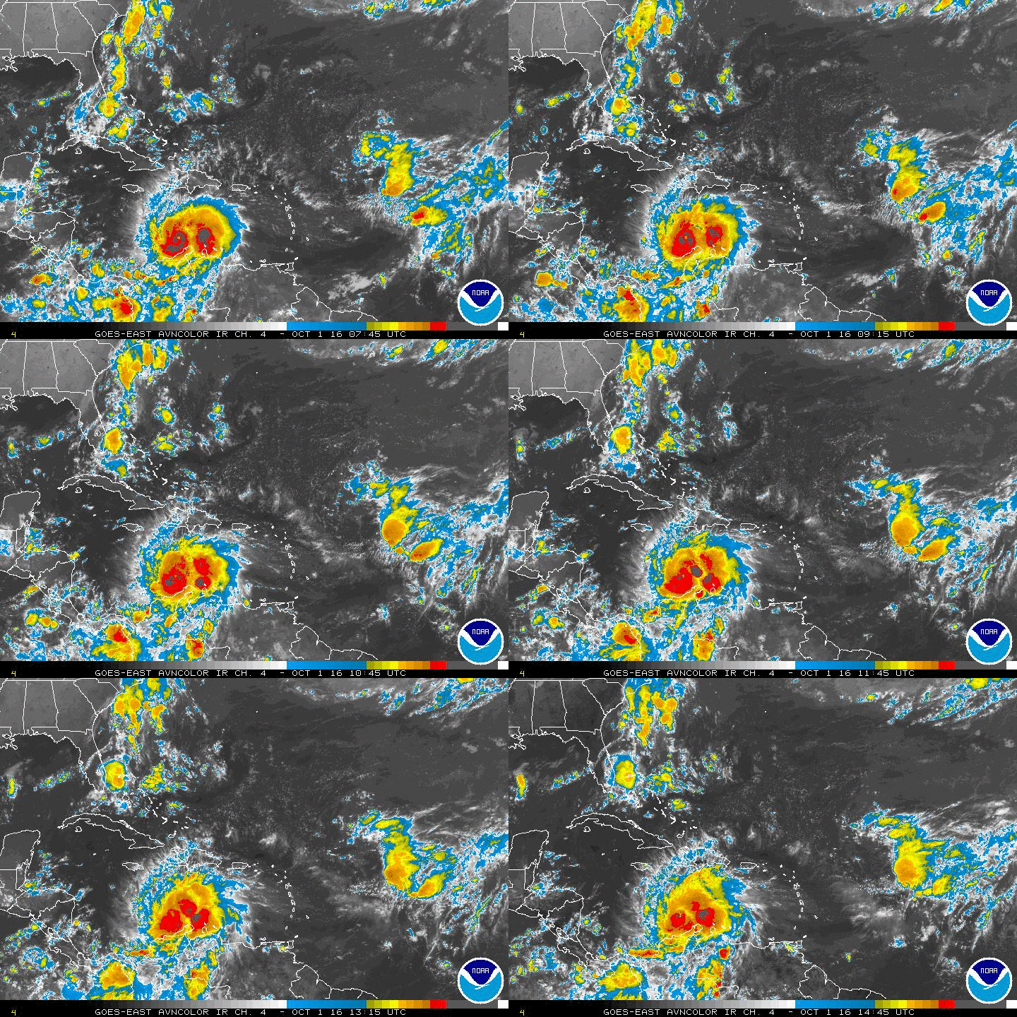
The GFS might be on to something. It appears part of the disturbed weather in the vicinity of Panama is moving northward.


0 likes
Tropicwatch
Agnes 72', Eloise 75, Elena 85', Kate 85', Charley 86', Florence 88', Beryl 94', Dean 95', Erin 95', Opal 95', Earl 98', Georges 98', Ivan 2004', Arlene 2005', Dennis 2005', Ida 2009' Debby 2012' Irma 2017' Michael 2018'
Agnes 72', Eloise 75, Elena 85', Kate 85', Charley 86', Florence 88', Beryl 94', Dean 95', Erin 95', Opal 95', Earl 98', Georges 98', Ivan 2004', Arlene 2005', Dennis 2005', Ida 2009' Debby 2012' Irma 2017' Michael 2018'
-
Dean4Storms
- S2K Supporter

- Posts: 6358
- Age: 63
- Joined: Sun Aug 31, 2003 1:01 pm
- Location: Miramar Bch. FL
-
TheStormExpert
-
TheStormExpert
Re: Global Model Runs Discussion
Dean4Storms wrote:^^^^^^^^^ Looks like a ridge setting up aloft.
Where?
0 likes
-
Dean4Storms
- S2K Supporter

- Posts: 6358
- Age: 63
- Joined: Sun Aug 31, 2003 1:01 pm
- Location: Miramar Bch. FL
Re: Global Model Runs Discussion
TheStormExpert wrote:Dean4Storms wrote:^^^^^^^^^ Looks like a ridge setting up aloft.
Where?
Right there over Central America, note the tops of convection moving off to the north then east north of Panama yet south and west to the South.
0 likes
-
Dean4Storms
- S2K Supporter

- Posts: 6358
- Age: 63
- Joined: Sun Aug 31, 2003 1:01 pm
- Location: Miramar Bch. FL
Re: Global Model Runs Discussion
Dean4Storms wrote:TheStormExpert wrote:Dean4Storms wrote:^^^^^^^^^ Looks like a ridge setting up aloft.
Where?
Right there over Central America, note the tops of convection moving off to the north then east north of Panama yet south and west to the South.
There is a clockwise turning there at upper levels.
0 likes
-
TheStormExpert
Re:
TheStormExpert wrote:You would think with the NAO being Negative we would be seeing more deepening troughs in the Eastern part of the U.S., guess that won't be the case?
NAO Forecast
Yeah that's really bizarre. The AO and NAO are forecasted to be very negative, the PNA positive. Yet for the Southeast (I'm in Orlando Florida), all the models show zero hint of these teleconnections. No cool weather whatsoever. Warm weather is forecasted in fact. Generally over the next two weeks mid to upper 80s highs and upper 60s low 70s (mainly low 70s) for lows. This warm weather forecast would indicate the lack of a trough.
What is going on? Why isn't the forecast reflecting these teleconnections?
0 likes
This post is NOT AN OFFICIAL FORECAST and should not be used as such. It is just the opinion of the poster and may or may not be backed by sound meteorological data. It is NOT endorsed by any professional institution including storm2k.org. For Official Information please refer to the NHC and NWS products.
-
TheStormExpert
Re: Re:
asd123 wrote:TheStormExpert wrote:You would think with the NAO being Negative we would be seeing more deepening troughs in the Eastern part of the U.S., guess that won't be the case?
NAO Forecast
Yeah that's really bizarre. The AO and NAO are forecasted to be very negative, the PNA positive. Yet for the Southeast (I'm in Orlando Florida), all the models show zero hint of these teleconnections. No cool weather whatsoever. Warm weather is forecasted in fact. Generally over the next two weeks mid to upper 80s highs and upper 60s low 70s (mainly low 70s) for lows.
What is going on? Why isn't the forecast reflecting these teleconnections?
Yeah, the AO is forecasted to really spike Negative before tending towards Neutral. As for the PNA, it is expected to spike Positive before going Negative again. This really makes no sense to me?
AO Forecast

PNA Forecast

0 likes
-
TheStormExpert
- Hurricaneman
- Category 5

- Posts: 7404
- Age: 45
- Joined: Tue Aug 31, 2004 3:24 pm
- Location: central florida
Re: Global Model Runs Discussion
Hurricaneman wrote:The 0zGFS has backed off on development
It definitely was a weaker genesis, the weakest in many runs. However, it still did have a SW Caribbean genesis for the 18th time in row. I do wonder if this weaker genesis is a sign of things to come lol.
0 likes
Personal Forecast Disclaimer:
The posts in this forum are NOT official forecasts and should not be used as such. They are just the opinion of the poster and may or may not be backed by sound meteorological data. They are NOT endorsed by any professional institution or storm2k.org. For official information, please refer to the NHC and NWS products.
The posts in this forum are NOT official forecasts and should not be used as such. They are just the opinion of the poster and may or may not be backed by sound meteorological data. They are NOT endorsed by any professional institution or storm2k.org. For official information, please refer to the NHC and NWS products.
Re: Global Model Runs Discussion
Hurricaneman wrote:The 0zGFS has backed off on development
Not surprised - other models will probably do the same.
0 likes
Based on the 240 hour map, I'm guessing it is going to push toward the western GoM again.
Edit: going to MX.
Edit: going to MX.
0 likes
Personal Forecast Disclaimer:
The posts in this forum are NOT official forecasts and should not be used as such. They are just the opinion of the poster and may or may not be backed by sound meteorological data. They are NOT endorsed by any professional institution or storm2k.org. For official information, please refer to the NHC and NWS products.
The posts in this forum are NOT official forecasts and should not be used as such. They are just the opinion of the poster and may or may not be backed by sound meteorological data. They are NOT endorsed by any professional institution or storm2k.org. For official information, please refer to the NHC and NWS products.
Who is online
Users browsing this forum: No registered users and 40 guests


