ATL: GONZALO - Post-Tropical - Discussion

Moderator: S2k Moderators

Message
Author
User avatar
NDG
S2K Supporter
S2K Supporter
Posts: 15446
Joined: Sun Jul 09, 2006 10:14 pm
Location: Orlando, FL

Re: ATL: GONZALO - Tropical Storm - Discussion

#341 Postby NDG » Mon Oct 13, 2014 9:28 am

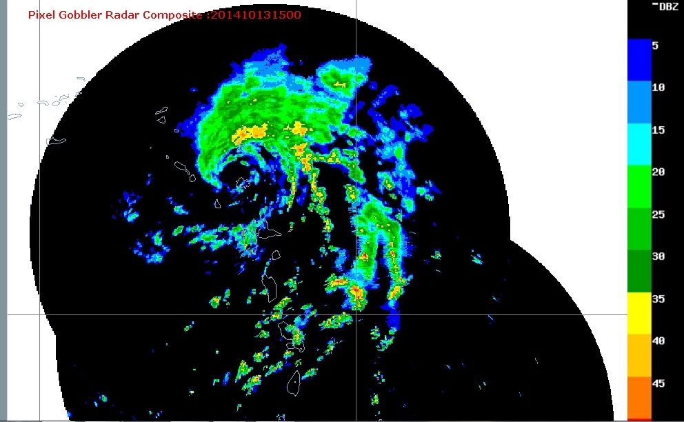
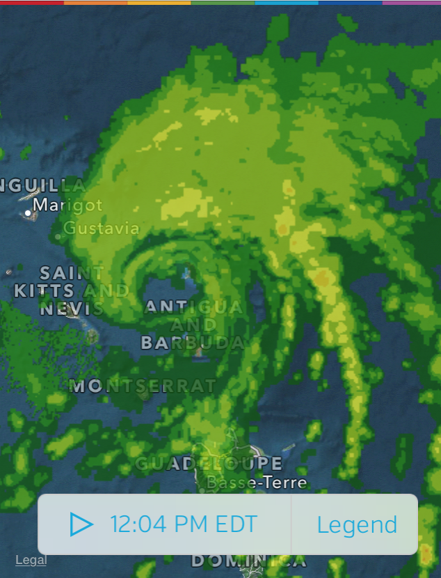
adam0983 wrote:What time frame should be the worst for st martin. The weather is overcast with some showers. Some hotels are putting shutters up now and the hotels are bringing in lounge chairs and tables


It should be going downhill over the next few hours.
0 likes   

User avatar
ronjon
Category 5
Category 5
Posts: 4822
Joined: Fri Aug 19, 2005 5:17 pm
Location: Hernando Beach, FL

Re: ATL: GONZALO - Tropical Storm - Discussion

#342 Postby ronjon » Mon Oct 13, 2014 9:40 am

Looks to have wobbled W-SW the last few hours.

http://www.ssd.noaa.gov/PS/TROP/floaters/08L/flash-vis-long.html
0 likes   

User avatar
NDG
S2K Supporter
S2K Supporter
Posts: 15446
Joined: Sun Jul 09, 2006 10:14 pm
Location: Orlando, FL

#343 Postby NDG » Mon Oct 13, 2014 9:41 am

We should begin to see an eye becoming visible on satellite during the next few hours.
0 likes   

User avatar
Gustywind
Category 5
Category 5
Posts: 12334
Joined: Mon Sep 03, 2007 7:29 am
Location: Baie-Mahault, GUADELOUPE

Re: ATL: GONZALO - Tropical Storm - Discussion

#344 Postby Gustywind » Mon Oct 13, 2014 9:42 am

ronjon wrote:Looks to have wobbled W-SW the last few hours.

http://www.ssd.noaa.gov/PS/TROP/floaters/08L/flash-vis-long.html

Absolutely that what my untrained eyes have seen too.
0 likes   

User avatar
SouthDadeFish
Professional-Met
Professional-Met
Posts: 2835
Joined: Thu Sep 23, 2010 2:54 pm
Location: Miami, FL
Contact:

#345 Postby SouthDadeFish » Mon Oct 13, 2014 9:44 am

I think y'all are tracking the older "eye" feature. That is rotating cyclonically inside the newly forming, larger eye. Hence the appearance of a southward component of motion. The system as a whole is continuing off to the W/WNW.
0 likes   

TJRE
Tropical Storm
Tropical Storm
Posts: 188
Joined: Sun Jun 02, 2013 9:04 am
Location: New Jersey

Re: ATL: GONZALO - Tropical Storm - Discussion

#346 Postby TJRE » Mon Oct 13, 2014 9:44 am

0 likes   

User avatar
NDG
S2K Supporter
S2K Supporter
Posts: 15446
Joined: Sun Jul 09, 2006 10:14 pm
Location: Orlando, FL

#347 Postby NDG » Mon Oct 13, 2014 9:52 am

I strongly disagree with the latest NHC estimated pressure for Gonzalo, clearly the 992mb pressure that the recon found 2 hours ago was not in its center.
0 likes   

User avatar
ronjon
Category 5
Category 5
Posts: 4822
Joined: Fri Aug 19, 2005 5:17 pm
Location: Hernando Beach, FL

Re: ATL: GONZALO - Tropical Storm - Discussion

#348 Postby ronjon » Mon Oct 13, 2014 9:53 am

...GONZALO STRENGTHENING WHILE IT MOVES THROUGH THE NORTHERN LEEWARD
ISLANDS...
...TROPICAL-STORM-FORCE WINDS CONTINUE ON ANTIGUA...


SUMMARY OF 1100 AM AST...1500 UTC...INFORMATION
-----------------------------------------------
LOCATION...17.2N 61.9W
ABOUT 10 MI...15 KM NW OF ANTIGUA
ABOUT 220 MI...355 KM ESE OF ST. THOMAS
MAXIMUM SUSTAINED WINDS...65 MPH...100 KM/H
PRESENT MOVEMENT...WNW OR 290 DEGREES AT 10 MPH...17 KM/H
MINIMUM CENTRAL PRESSURE...992 MB...29.30 INCHES
0 likes   

User avatar
ronjon
Category 5
Category 5
Posts: 4822
Joined: Fri Aug 19, 2005 5:17 pm
Location: Hernando Beach, FL

Re: ATL: GONZALO - Tropical Storm - Discussion

#349 Postby ronjon » Mon Oct 13, 2014 9:54 am

Not long now before Gonzalo becomes a hurricane.
0 likes   

User avatar
NDG
S2K Supporter
S2K Supporter
Posts: 15446
Joined: Sun Jul 09, 2006 10:14 pm
Location: Orlando, FL

#350 Postby NDG » Mon Oct 13, 2014 10:14 am

Latest radar image:

Image
0 likes   

User avatar
Nimbus
Category 5
Category 5
Posts: 5300
Joined: Mon Jul 19, 2004 10:54 am

Re: ATL: GONZALO - Tropical Storm - Discussion

#351 Postby Nimbus » Mon Oct 13, 2014 10:18 am

The official forecast still puts Puerto Rico on the weak side of the storm.
That should keep the winds below hurricane strength but still give them some rain.
Thought I noticed a wobble south of west a few frames ago, hope the next one is NW.
0 likes   

User avatar
TheAustinMan
Category 5
Category 5
Posts: 1047
Age: 25
Joined: Mon Jul 08, 2013 4:26 pm
Location: United States
Contact:

#352 Postby TheAustinMan » Mon Oct 13, 2014 10:27 am

Loop I created overlaying radar with satellite imagery since sunup.
Image
Last edited by TheAustinMan on Mon Oct 13, 2014 10:28 am, edited 1 time in total.
0 likes   
ImageImageImage
Treat my opinions with a grain of salt. For official information see your local weather service.

User avatar
msbee
S2K Supporter
S2K Supporter
Posts: 3027
Joined: Wed Jun 11, 2003 10:11 am
Location: St. Maarten

#353 Postby msbee » Mon Oct 13, 2014 10:28 am

St Maarten
11 AM wind ENE at 23 MPH
pressure 1011
0 likes   
Too many hurricanes to remember

User avatar
tropicwatch
Category 5
Category 5
Posts: 3383
Age: 61
Joined: Sat Jun 02, 2007 10:01 am
Location: Panama City Florida
Contact:

#354 Postby tropicwatch » Mon Oct 13, 2014 10:32 am

I am kind of surprised that they didn't shift the forecast past a little further west. I haven't seen any indication of a northwest motion yet.

Image
0 likes   
Tropicwatch


Agnes 72', Eloise 75, Elena 85', Kate 85', Charley 86', Florence 88', Beryl 94', Dean 95', Erin 95', Opal 95', Earl 98', Georges 98', Ivan 2004', Arlene 2005', Dennis 2005', Ida 2009' Debby 2012' Irma 2017' Michael 2018'

User avatar
abajan
S2K Supporter
S2K Supporter
Posts: 4230
Joined: Sun Sep 07, 2003 5:10 am
Location: Barbados

#355 Postby abajan » Mon Oct 13, 2014 10:37 am

It's about time the "Invest 90L" text disappears from the S2K chart! (I know it's all automatic but still ...)
0 likes   

User avatar
Gustywind
Category 5
Category 5
Posts: 12334
Joined: Mon Sep 03, 2007 7:29 am
Location: Baie-Mahault, GUADELOUPE

Re:

#356 Postby Gustywind » Mon Oct 13, 2014 10:51 am

abajan wrote:It's about time the "Invest 90L" text disappears from the S2K chart! (I know it's all automatic but still ...)

:cheesy: :lol: :) yeah fore sure Abajan.
0 likes   

HurricaneRyan
Category 3
Category 3
Posts: 813
Age: 31
Joined: Sun Dec 05, 2010 3:05 pm

#357 Postby HurricaneRyan » Mon Oct 13, 2014 10:52 am

Wow! Wasn't expecting a good storm like this to form this month! Let alone, a good Caribbean storm
0 likes   
Kay '22 Hilary '23

User avatar
weathernerdguy
Tropical Storm
Tropical Storm
Posts: 188
Age: 23
Joined: Wed Jul 10, 2013 8:44 pm

#358 Postby weathernerdguy » Mon Oct 13, 2014 10:54 am

This goes to show that a season with a few storms means nothing
0 likes   
The posts in this forum are NOT official forecast and should not be used as such. They are just the opinion of the poster and may or may not be backed by sound meteorological data. They are NOT endorsed by any professional institution or storm2k.org. For official information, please refer to the NHC and NWS products

User avatar
wxman57
Moderator-Pro Met
Moderator-Pro Met
Posts: 22978
Age: 67
Joined: Sat Jun 21, 2003 8:06 pm
Location: Houston, TX (southwest)

Re: ATL: GONZALO - Tropical Storm - Discussion

#359 Postby wxman57 » Mon Oct 13, 2014 11:07 am

12Z GFS has the center passing directly over Bermuda on Friday. Perhaps this time they'll heed the warnings better.
0 likes   

User avatar
NDG
S2K Supporter
S2K Supporter
Posts: 15446
Joined: Sun Jul 09, 2006 10:14 pm
Location: Orlando, FL

#360 Postby NDG » Mon Oct 13, 2014 11:09 am

We now have a closed eye on radar.

Image
0 likes   


Return to “2014”

Who is online

Users browsing this forum: No registered users and 2 guests