
ATL: GONZALO - Post-Tropical - Discussion
Moderator: S2k Moderators
-
cycloneye

- Admin

- Posts: 149508
- Age: 69
- Joined: Thu Oct 10, 2002 10:54 am
- Location: San Juan, Puerto Rico
Re: ATL: GONZALO - Hurricane - Discussion
As Crazy said big data coming and here it is.
0 likes
Visit the Caribbean-Central America Weather Thread where you can find at first post web cams,radars
and observations from Caribbean basin members Click Here
and observations from Caribbean basin members Click Here
-
supercane4867
- Category 5

- Posts: 4966
- Joined: Wed Nov 14, 2012 10:43 am
Re: ATL: GONZALO - Hurricane - Discussion
That pressure drop confirms Gonzalo is officially undergoing RI
0 likes
-
northjaxpro

- S2K Supporter

- Posts: 8900
- Joined: Mon Sep 27, 2010 11:21 am
- Location: Jacksonville, FL
Re:
CrazyC83 wrote:Recon having issues now? Could there be extreme turbulence a la Felix?
With a hurricane this strong, I wouldn't doubt at all that they are having a bumpy ride to say the least right now.
0 likes
NEVER, EVER SAY NEVER in the tropics and weather in general, and most importantly, with life itself!!
________________________________________________________________________________________
Fay 2008 Beryl 2012 Debby 2012 Colin 2016 Hermine 2016 Julia 2016 Matthew 2016 Irma 2017 Dorian 2019
________________________________________________________________________________________
Fay 2008 Beryl 2012 Debby 2012 Colin 2016 Hermine 2016 Julia 2016 Matthew 2016 Irma 2017 Dorian 2019

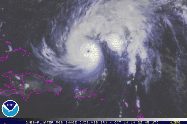
That photo is incredible. Seems like the best looking storm this year. I hope all in Bermuda stay safe.
0 likes
The following post is NOT an official forecast and should not be used as such. It is just the opinion of the poster and may or may not be backed by sound meteorological data. It is NOT endorsed by any professional institution including storm2k.org. For Official Information please refer to the NHC and NWS products.
-
EquusStorm
- Category 5
- Posts: 1649
- Age: 35
- Joined: Thu Nov 07, 2013 1:04 pm
- Location: Jasper, AL
- Contact:
Inner core structure just continues to look more impressive. Really goes well with the rapid pressure drop... no doubt we'll have a category four on our hands by morning, if not sooner.

0 likes
Colors of lost purpose on the canvas of irrelevance
Not a meteorologist, in fact more of an idiot than anything. You should probably check with the NHC or a local NWS office for official information.
Not a meteorologist, in fact more of an idiot than anything. You should probably check with the NHC or a local NWS office for official information.
-
cycloneye
- Admin
- Posts: 149508
- Age: 69
- Joined: Thu Oct 10, 2002 10:54 am
- Location: San Juan, Puerto Rico
Re: ATL: GONZALO - Hurricane - Discussion
They are releasing again the data.
URNT12 KNHC 142302
VORTEX DATA MESSAGE AL082014
A. 14/22:42:00Z
B. 21 deg 34 min N
066 deg 04 min W
C. 700 mb 2747 m
D. 107 kt
E. 239 deg 6 nm
F. 334 deg 88 kt
G. 239 deg 6 nm
H. 959 mb
I. 10 C / 3022 m
J. 20 C / 3022 m
K. NA / NA
L. CLOSED
M. C10
N. 12345 / 07
O. 0.02 / 1 nm
P. AF302 0608A GONZALO OB 07
MAX OUTBOUND AND MAX FL WIND 125 KT 055 / 7 NM 22:44:00Z
CNTR DROPSONDE SFC WINDS 160 / 21 KT
;
0 likes
Visit the Caribbean-Central America Weather Thread where you can find at first post web cams,radars
and observations from Caribbean basin members Click Here
and observations from Caribbean basin members Click Here

Not to be alarmist or anything but is it possible this could reach Cat 5 if it is indeed strengthening as quickly as it seems?
0 likes
The above post is not official and should not be used as such. It is the opinion of the poster and may or may not be backed by sound meteorological data. It is not endorsed by any professional institution or storm2k.org. For official information, please refer to the NHC and NWS products.
-
northjaxpro
- S2K Supporter
- Posts: 8900
- Joined: Mon Sep 27, 2010 11:21 am
- Location: Jacksonville, FL
Re:
Hammy wrote:Not to be alarmist or anything but is it possible this could reach Cat 5 if it is indeed strengthening as quickly as it seems?
It is almost about at Cat 4 strength now at the rate it is strengthening currently.
Well, with the conditions being very ideal for strengthening in the short term, it is conceivable that it could reach Cat 5 up to about 48 hours on its approach to Bermuda.
0 likes
NEVER, EVER SAY NEVER in the tropics and weather in general, and most importantly, with life itself!!
________________________________________________________________________________________
Fay 2008 Beryl 2012 Debby 2012 Colin 2016 Hermine 2016 Julia 2016 Matthew 2016 Irma 2017 Dorian 2019
________________________________________________________________________________________
Fay 2008 Beryl 2012 Debby 2012 Colin 2016 Hermine 2016 Julia 2016 Matthew 2016 Irma 2017 Dorian 2019
-
supercane4867
- Category 5
- Posts: 4966
- Joined: Wed Nov 14, 2012 10:43 am
Re: ATL: GONZALO - Hurricane - Discussion
Honestly it needs to look much more impressive than it is right now to reach Cat.5

0 likes
-
ozonepete
- Professional-Met

- Posts: 4743
- Joined: Mon Sep 07, 2009 3:23 pm
- Location: From Ozone Park, NYC / Now in Brooklyn, NY
Re: ATL: GONZALO - Hurricane - Discussion
Very, very impressive satellite presentation. I'm also beginning to believe this has a shot at cat 5 due to its smaller size, and SSTs are good enough to do it.

0 likes
-
EquusStorm
- Category 5
- Posts: 1649
- Age: 35
- Joined: Thu Nov 07, 2013 1:04 pm
- Location: Jasper, AL
- Contact:
It would certainly be climatologically unprecedented for a storm to reach category five at that location and time of year... but then again, it's not exactly following the norms as it is. This track is much more like a late August or early September track. I can't say I personally would expect such extreme intensity, but conditions don't really seem to be prohibitive for further explosive development, perhaps even to that point... so I say, for such a rare opportunity to re-write some Atlantic climatology records, go for it, Gonzalo.
0 likes
Colors of lost purpose on the canvas of irrelevance
Not a meteorologist, in fact more of an idiot than anything. You should probably check with the NHC or a local NWS office for official information.
Not a meteorologist, in fact more of an idiot than anything. You should probably check with the NHC or a local NWS office for official information.
-
EquusStorm
- Category 5
- Posts: 1649
- Age: 35
- Joined: Thu Nov 07, 2013 1:04 pm
- Location: Jasper, AL
- Contact:
Exactly. And there have been few category five storms in ANY season in this area of the Atlantic, outside of the Bahamas or off the southeast coast of Florida. Some, yes, but not many.
0 likes
Colors of lost purpose on the canvas of irrelevance
Not a meteorologist, in fact more of an idiot than anything. You should probably check with the NHC or a local NWS office for official information.
Not a meteorologist, in fact more of an idiot than anything. You should probably check with the NHC or a local NWS office for official information.

Re: ATL: GONZALO - Hurricane - Discussion
btw, if anyone is interested in local news in Bermuda check out http://www.bernews.com they are usually pretty good and they have already started a live blog with regard to the hurricane.
0 likes
Who is online
Users browsing this forum: No registered users and 35 guests