Texas Fall-2014

U.S. & Caribbean Weather Discussions and Severe Weather Events

Moderator: S2k Moderators

Forum rules

The posts in this forum are NOT official forecast and should not be used as such. They are just the opinion of the poster and may or may not be backed by sound meteorological data. They are NOT endorsed by any professional institution or STORM2K.

Help Support Storm2K
Message
Author
User avatar
Portastorm
Storm2k Moderator
Storm2k Moderator
Posts: 9914
Age: 63
Joined: Fri Jul 11, 2003 9:16 am
Location: Round Rock, TX
Contact:

Re:

#741 Postby Portastorm » Fri Oct 31, 2014 10:19 am

TheProfessor wrote::uarrow: Doesn't a costal low take away moisture from North Texas and leave us dry?


It can ... but in this instance, the frontal boundary and some upper level energy will certainly impact your part of the state prior to any coastal low developing.
0 likes   
Any forecasts under my name are to be taken with a grain of salt. Get your best forecasts from the National Weather Service and National Hurricane Center.

User avatar
srainhoutx
S2K Supporter
S2K Supporter
Posts: 6919
Age: 67
Joined: Sun Jan 14, 2007 11:34 am
Location: Haywood County, NC
Contact:

Re:

#742 Postby srainhoutx » Fri Oct 31, 2014 10:21 am

TheProfessor wrote::uarrow: Doesn't a costal low take away moisture from North Texas and leave us dry?


With a SW flow off the Pacific and a nice tap of deep tropical moisture from the remnants of Vance all the way back to SE of Hawaii at the mid/upper levels streaming NE, I feel fairly confident everyone across Texas will see some beneficial rainfall.

Image
0 likes   
Carla/Alicia/Jerry(In The Eye)/Michelle/Charley/Ivan/Dennis/Katrina/Rita/Wilma/Ike/Harvey

Member: National Weather Association
Wx Infinity Forums
http://wxinfinity.com/index.php

Facebook.com/WeatherInfinity
Twitter @WeatherInfinity

User avatar
Ntxw
Storm2k Moderator
Storm2k Moderator
Posts: 22785
Joined: Wed Oct 21, 2009 6:34 pm
Location: DFW, Texas

#743 Postby Ntxw » Fri Oct 31, 2014 10:26 am

#SubtropicalJet
0 likes   
The above post and any post by Ntxw is NOT an official forecast and should not be used as such. It is just the opinion of the poster and may or may not be backed by sound meteorological data. It is NOT endorsed by any professional institution including Storm2k. For official information, please refer to NWS products.

  Help support Storm2K!
Help Support Storm2K

aggiecutter
Category 5
Category 5
Posts: 1753
Joined: Thu Oct 14, 2004 9:22 pm
Location: Texarkana

Re: Texas Fall-2014

#744 Postby aggiecutter » Fri Oct 31, 2014 10:34 am

Freeze Warning
URGENT - WEATHER MESSAGE
NATIONAL WEATHER SERVICE SHREVEPORT LA
429 AM CDT FRI OCT 31 2014

...BECOMING WINDY BY LATE MORNING FOR THE FOUR STATE AREA LASTING
UNTIL AROUND SUNSET...THEN AFTER WINDS ABATE TEMPERATURES WILL
FALL WITH A FREEZE LATE TONIGHT UNTIL 8 TO 9 AM CDT SATURDAY.

.COLD ARCTIC AIR WILL SPREAD SOUTH INTO THE REGION RESULTING IN
FREEZING TEMPERATURES FOR MUCH OF THE INTERSTATE 30 CORRIDOR
AND NORTH TO INCLUDE SOUTHEAST OKLAHOMA...NORTHEAST TEXAS
AND SOUTHWEST ARKANSAS.

ARZ050-051-059-070-OKZ077-TXZ096-097-108>112-312100-
/O.NEW.KSHV.FZ.W.0004.141101T0800Z-141101T1400Z/
/O.CON.KSHV.LW.Y.0045.141031T1600Z-141101T0000Z/
SEVIER-HOWARD-LITTLE RIVER-MILLER-MCCURTAIN-RED RIVER-BOWIE-
FRANKLIN-TITUS-CAMP-MORRIS-CASS-
INCLUDING THE CITIES OF...DE QUEEN...NASHVILLE...ASHDOWN...
TEXARKANA...IDABEL...CLARKSVILLE...MT VERNON...MT PLEASANT...
PITTSBURG...DAINGERFIELD...ATLANTA
429 AM CDT FRI OCT 31 2014
0 likes   

aggiecutter
Category 5
Category 5
Posts: 1753
Joined: Thu Oct 14, 2004 9:22 pm
Location: Texarkana

Re: Texas Fall-2014

#745 Postby aggiecutter » Fri Oct 31, 2014 10:40 am

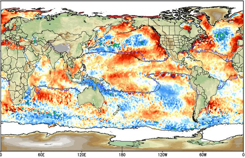
Bad news for upcoming winter: Warm patch of water in GOA has been replaced by a cold patch. Lets see if the trend continues.

Image
0 likes   

veedub63
S2K Supporter
S2K Supporter
Posts: 24
Joined: Tue Nov 26, 2013 11:49 am
Location: Lago Vista, Texas

Re: Texas Fall-2014

#746 Postby veedub63 » Fri Oct 31, 2014 11:16 am

aggiecutter wrote:Bad news for upcoming winter: Warm patch of water in GOA has been replaced by a cold patch. Lets see if the trend continues.


Is this bad news because you were hoping for cold and snowy OR is this bad news because you were hoping for sunny and warm? The vagueness of the statement left me confused.
0 likes   
I am neither a professional meteorologist nor an amateur meteorologist. Please do not consider any of my posts to be a forecast of anything. Anything I post that is remotely forward looking should be considered speculation at best.

weatherdude1108
Category 5
Category 5
Posts: 4228
Joined: Tue Dec 13, 2011 1:04 pm
Location: Northwest Austin/Cedar Park, TX

Re: Texas Fall-2014

#747 Postby weatherdude1108 » Fri Oct 31, 2014 11:33 am

veedub63 wrote:
aggiecutter wrote:Bad news for upcoming winter: Warm patch of water in GOA has been replaced by a cold patch. Lets see if the trend continues.


Is this bad news because you were hoping for cold and snowy OR is this bad news because you were hoping for sunny and warm? The vagueness of the statement left me confused.


I had that question also(?). Not sure how to decipher it.
0 likes   

User avatar
srainhoutx
S2K Supporter
S2K Supporter
Posts: 6919
Age: 67
Joined: Sun Jan 14, 2007 11:34 am
Location: Haywood County, NC
Contact:

Re: Texas Fall-2014

#748 Postby srainhoutx » Fri Oct 31, 2014 11:39 am

aggiecutter wrote:Bad news for upcoming winter: Warm patch of water in GOA has been replaced by a cold patch. Lets see if the trend continues.

Image


In a Nina year, that would be a drier solution for Winter across our Region. Typically we see the N Pacific cool when El Nino develops and our source Regions of NW Alaska/Western Canada should allow for much stronger and deeper cold intrusions E of the Rockies. The Sub tropical jet will be the driver of our precipitation this year and chances of marginal temperature as we experienced last year should be much 'chillier'.
Last edited by srainhoutx on Fri Oct 31, 2014 11:47 am, edited 1 time in total.
0 likes   
Carla/Alicia/Jerry(In The Eye)/Michelle/Charley/Ivan/Dennis/Katrina/Rita/Wilma/Ike/Harvey

Member: National Weather Association
Wx Infinity Forums
http://wxinfinity.com/index.php

Facebook.com/WeatherInfinity
Twitter @WeatherInfinity

User avatar
Portastorm
Storm2k Moderator
Storm2k Moderator
Posts: 9914
Age: 63
Joined: Fri Jul 11, 2003 9:16 am
Location: Round Rock, TX
Contact:

Re: Texas Fall-2014

#749 Postby Portastorm » Fri Oct 31, 2014 11:45 am

:uarrow:

Agreed! Also, the SST anomalies in the North Pacific are not the only "driver" of our upcoming winter like they were last winter. While some of those north central Pacific SSTs are cooling there remains an extremely warm ribbon of warm ocean water along the West Coast. This coming season we'll have an active southern jet and a more persistant negative AO and NAO/Greenland block. The cold will be coming at us from multiple directions (NW and NE). And those upper lows which will cross Texas west to east will entrain cold air underneath them.
0 likes   
Any forecasts under my name are to be taken with a grain of salt. Get your best forecasts from the National Weather Service and National Hurricane Center.

User avatar
TheProfessor
Professional-Met
Professional-Met
Posts: 3506
Age: 28
Joined: Tue Dec 03, 2013 10:56 am
Location: Wichita, Kansas

#750 Postby TheProfessor » Fri Oct 31, 2014 12:03 pm

I can't post a image right now, but the NWS FWD has the low going through the Panhandle in west Texas, and if it were winter time, that kind of path would usually lead to winter weather for North and Central Texas unless there was a lack of moisture or if it made a sharp Northeast turn. Is this what you guys meant by pay attention to what happens now?
0 likes   
An alumnus of The Ohio State University.

Your local National Weather Service office is your best source for weather information.

User avatar
gboudx
S2K Supporter
S2K Supporter
Posts: 4080
Joined: Thu Sep 04, 2003 1:39 pm
Location: Rockwall, Tx but from Harvey, La

Re: Texas Fall-2014

#751 Postby gboudx » Fri Oct 31, 2014 12:10 pm

This is the image Professor is referring to. I didn't save it, only copied the URL straight from the NWS so expect it to change at some point.

Image
0 likes   

User avatar
Portastorm
Storm2k Moderator
Storm2k Moderator
Posts: 9914
Age: 63
Joined: Fri Jul 11, 2003 9:16 am
Location: Round Rock, TX
Contact:

Re: Texas Fall-2014

#752 Postby Portastorm » Fri Oct 31, 2014 12:14 pm

:uarrow:

Generally speaking, yes that is what I meant. We're going to be seeing a good inflow of Pacific moisture, upper level lows ... some will stay intact and some will shear out. Those that shear out often transfer energy into developing coastal lows. And we'll have cold, Polar air moving north to south and into these cold, deep troughs. I personally wouldn't be surprised to see next week's pattern repeated fairly often this winter.
0 likes   
Any forecasts under my name are to be taken with a grain of salt. Get your best forecasts from the National Weather Service and National Hurricane Center.

User avatar
Ntxw
Storm2k Moderator
Storm2k Moderator
Posts: 22785
Joined: Wed Oct 21, 2009 6:34 pm
Location: DFW, Texas

#753 Postby Ntxw » Fri Oct 31, 2014 8:42 pm

Lets take this and call it a day

Image
0 likes   
The above post and any post by Ntxw is NOT an official forecast and should not be used as such. It is just the opinion of the poster and may or may not be backed by sound meteorological data. It is NOT endorsed by any professional institution including Storm2k. For official information, please refer to NWS products.


  Help support Storm2K!

Help Support Storm2K


User avatar
dhweather
S2K Supporter
S2K Supporter
Posts: 6199
Joined: Sat Aug 14, 2004 9:29 pm
Location: Heath, TX
Contact:

Re:

#754 Postby dhweather » Fri Oct 31, 2014 9:48 pm

Ntxw wrote:Lets take this and call it a day

Image


AMEN!


Bombogenesis - that is an awesome word ntxw, I love it!
0 likes   
The above post and any post by dhweather is NOT an official forecast and should not be used as such. It is just the opinion of the poster and may or may not be backed by sound meteorological data. It is NOT endorsed by any professional institution including storm2k.org. For official information, please refer to NWS products.

weatherdude1108
Category 5
Category 5
Posts: 4228
Joined: Tue Dec 13, 2011 1:04 pm
Location: Northwest Austin/Cedar Park, TX

#755 Postby weatherdude1108 » Fri Oct 31, 2014 10:52 pm

This forecast brings back October '98 memories.
My brother in San Antonio said that Steve Brown, long-time tv weatherman down there just talked bout '98 and said gulf water temp was 9 degrees warmer back in '98, and that 1 degree equals 5% more moisture in the air. Anyway, still looking UP! These kinds of setups tend to fill up lakes and aquifers. The following is from Bob Rose's blog today (Friday):

The developing trough of low pressure over the southwestern US is expected to pull considerable moisture into Texas off the Gulf of Mexico beginning late Monday. Meanwhile, considerable middle and high-level moisture associated with eastern Pacific tropical storm Vance will also be drawn north into Texas by the same upper trough. The result will be an unstable and nearly saturated atmosphere, causing the development of widespread showers and thunderstorms. A cold front pushing east out of West Texas is forecast to slow down over the Hill Country late Tuesday into Wednesday. The front has the potential to become the focus for moderate to heavy rain. Today's solutions call for the cold front to be over the Hill Country next Tuesday and Tuesday night, shifting east to Central Texas on Wednesday and the coastal plains region on Thursday. The front is forecast to weaken Thursday while light to moderate rains continue across the entire region. Some of today's solutions indicate rain showers will continue into early Friday before the trough of low pressure finally exits to the east.

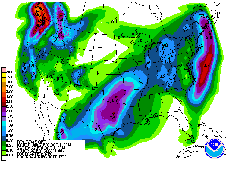
Widespread rainfall amounts of 2-4 inches appears likely with next week's rain event, but I'll caution these forecasted totals could go higher depending on the amount of moisture flowing north from tropical storm Vance and the speed of the cold front. We'll get a better handle of the amount of rain expected by late Sunday as we get closer to event.

Friday afternoon's National Weather Service 7-day rainfall forecast, for the period from this evening through next Friday, evening, calls for totals of 4 to 6 inches occurring across the eastern Hill Country and much of Central Texas:

Historically speaking, next week's rain event looks somewhat similar to previous fall heavy rain events occurring across Central and South during October 1994, October 1998, October 2002 and October 2006. Each of these rain events included a trough of low pressure over the southwestern US, a slow-moving cold front and the remnants of an eastern Pacific tropical cyclone.

http://www.lcra.org/water/river-and-wea ... ather.aspx
0 likes   
The preceding post is NOT an official forecast, and should not be used as such. It is only the opinion of the poster and may or may not be backed by sound meteorological data. It is NOT endorsed by any professional institution including storm2k.org. For Official Information please refer to the NHC and NWS products.

User avatar
Ntxw
Storm2k Moderator
Storm2k Moderator
Posts: 22785
Joined: Wed Oct 21, 2009 6:34 pm
Location: DFW, Texas

#756 Postby Ntxw » Sat Nov 01, 2014 5:11 am

39F so far this morning, first sub 40 temperature of the season to kick off November. Any memories of summer is long gone, winter is just around the corner. Don't forget to change your clocks tonight.
0 likes   
The above post and any post by Ntxw is NOT an official forecast and should not be used as such. It is just the opinion of the poster and may or may not be backed by sound meteorological data. It is NOT endorsed by any professional institution including Storm2k. For official information, please refer to NWS products.


  Help support Storm2K!

Help Support Storm2K


User avatar
TheProfessor
Professional-Met
Professional-Met
Posts: 3506
Age: 28
Joined: Tue Dec 03, 2013 10:56 am
Location: Wichita, Kansas

Re: Texas Fall-2014

#757 Postby TheProfessor » Sat Nov 01, 2014 6:23 am

I was really hoping for the 5+ inches of rain WPC was predicting earlier, hopefully the models will trend wetter again.

Image
0 likes   
An alumnus of The Ohio State University.

Your local National Weather Service office is your best source for weather information.

User avatar
Ntxw
Storm2k Moderator
Storm2k Moderator
Posts: 22785
Joined: Wed Oct 21, 2009 6:34 pm
Location: DFW, Texas

#758 Postby Ntxw » Sat Nov 01, 2014 9:10 am

A little late on the convo, but for those of you worrying about SST's, the warmth around Alaska isn't going away it's solidy +PDO signature. Just the warm tongue into the GOA is being replaced by a cold tongue by El Nino which further means the Nino will control the winter. Like Srain said if we had a La Nina or even a strong Nino the story would be different but we don't. Take a look at 1977-1978 DJF (that is a top SST analog I can find).

Image

CFSv2 says Portastorm's forecast kicks off cold (below average) for November and stays cold right through for the state through 45 days
0 likes   
The above post and any post by Ntxw is NOT an official forecast and should not be used as such. It is just the opinion of the poster and may or may not be backed by sound meteorological data. It is NOT endorsed by any professional institution including Storm2k. For official information, please refer to NWS products.


  Help support Storm2K!

Help Support Storm2K


User avatar
TeamPlayersBlue
Category 5
Category 5
Posts: 3445
Joined: Tue Feb 02, 2010 1:44 am
Location: Denver/Applewood, CO

Re: Re:

#759 Postby TeamPlayersBlue » Sat Nov 01, 2014 11:40 am

#SubtropicalJet


Heeeee'sssss baaaaacckkkkkk
0 likes   
Personal Forecast Disclaimer:
The posts in this forum are NOT official forecast and should not be used as such. They are just the opinion of the poster and may or may not be backed by sound meteorological data. They are NOT endorsed by any professional institution or storm2k.org. For official information, please refer to the NHC and NWS products.

User avatar
Ptarmigan
Category 5
Category 5
Posts: 5313
Joined: Wed Aug 16, 2006 9:06 pm

Re:

#760 Postby Ptarmigan » Sat Nov 01, 2014 12:37 pm

Ntxw wrote:A little late on the convo, but for those of you worrying about SST's, the warmth around Alaska isn't going away it's solidy +PDO signature. Just the warm tongue into the GOA is being replaced by a cold tongue by El Nino which further means the Nino will control the winter. Like Srain said if we had a La Nina or even a strong Nino the story would be different but we don't. Take a look at 1977-1978 DJF (that is a top SST analog I can find).

Image

CFSv2 says Portastorm's forecast kicks off cold (below average) for November and stays cold right through for the state through 45 days


I have seen warm Northeast Pacific in both cool and warm PDO. Usually when there is El Nino, it is cooler, but not always. Also, I have seen negative East Pacific Oscillation (EPO) when the Northeast Pacific is cool like in February 1989. The warm Northeast Pacific was a factor for last winter for being cold.
0 likes   


Return to “USA & Caribbean Weather”

Who is online

Users browsing this forum: No registered users and 19 guests