#755 Postby weatherdude1108 » Fri Oct 31, 2014 10:52 pm
This forecast brings back October '98 memories.
My brother in San Antonio said that Steve Brown, long-time tv weatherman down there just talked bout '98 and said gulf water temp was 9 degrees warmer back in '98, and that 1 degree equals 5% more moisture in the air. Anyway, still looking UP! These kinds of setups tend to fill up lakes and aquifers. The following is from Bob Rose's blog today (Friday):
The developing trough of low pressure over the southwestern US is expected to pull considerable moisture into Texas off the Gulf of Mexico beginning late Monday. Meanwhile, considerable middle and high-level moisture associated with eastern Pacific tropical storm Vance will also be drawn north into Texas by the same upper trough. The result will be an unstable and nearly saturated atmosphere, causing the development of widespread showers and thunderstorms. A cold front pushing east out of West Texas is forecast to slow down over the Hill Country late Tuesday into Wednesday. The front has the potential to become the focus for moderate to heavy rain. Today's solutions call for the cold front to be over the Hill Country next Tuesday and Tuesday night, shifting east to Central Texas on Wednesday and the coastal plains region on Thursday. The front is forecast to weaken Thursday while light to moderate rains continue across the entire region. Some of today's solutions indicate rain showers will continue into early Friday before the trough of low pressure finally exits to the east.
Widespread rainfall amounts of 2-4 inches appears likely with next week's rain event, but I'll caution these forecasted totals could go higher depending on the amount of moisture flowing north from tropical storm Vance and the speed of the cold front. We'll get a better handle of the amount of rain expected by late Sunday as we get closer to event.
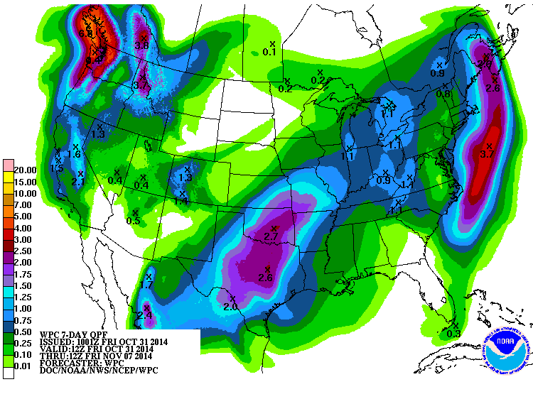
Friday afternoon's National Weather Service 7-day rainfall forecast, for the period from this evening through next Friday, evening, calls for totals of 4 to 6 inches occurring across the eastern Hill Country and much of Central Texas:
Historically speaking, next week's rain event looks somewhat similar to previous fall heavy rain events occurring across Central and South during October 1994, October 1998, October 2002 and October 2006. Each of these rain events included a trough of low pressure over the southwestern US, a slow-moving cold front and the remnants of an eastern Pacific tropical cyclone.
http://www.lcra.org/water/river-and-wea ... ather.aspx
0 likes
The preceding post is NOT an official forecast, and should not be used as such. It is only the opinion of the poster and may or may not be backed by sound meteorological data. It is NOT endorsed by any professional institution including storm2k.org. For Official Information please refer to the NHC and NWS products.