
Moderator: S2k Moderators
 The posts in this forum are NOT official forecast and should not be used as such. They are just the opinion of the poster and may or may not be backed by sound meteorological data. They are NOT endorsed by any professional institution or STORM2K.
Portastorm wrote:wxman57 wrote:I'm back for one day and I got the Euro to stop forecasting snow for the TX panhandle & Oklahoma in a single run! Let the heat begin...00Z Euro now has some snow in central/northern Arkansas around the 19th, but no significant cold for TX through the 23rd.
Don't you have something better to do ... like a nice 30-mile bike ride or Christmas shopping or something?! Leave the weather alone!
I knew his return would only mean warmth and bad things.
C'mon gang, we have to do something about the longer-range models. The PWC is hard at work already to bring snow, ice, and frosty goodness to Texas and wxman57's house.

No, no,no,no,no ! Latest upper-air data set shows a relatively strong cap moving northward out of Mexico headed for north Texas!! It has already moved over Del Rio as it lifts to the north. We do NOT need this ... bad bad timing.
The latest Texas Tech model - which yesterday showed a squall line of storms moving through our area on Sunday afternoon/evening - has spotted the cap and now completely dismisses the possibility of a squall line for us.
Now, this could all be an overreaction by the models. Whenever they see a cap moving in, they have a difficult time determining just how strong it will be by the time it gets here. We often get very little data out of Mexico, so we are seldom sure just how strong and what the impact will be of these caps coming off the high plateaus down there.
Stay tuned...perhaps it is just a computer model hiccup. The math has been so consistent up until this point !


srainhoutx wrote:While it is a long way out, the 12Z parallel GFS is suggesting a monster Winter Storm around Christmas with a slow developing NW Gulf Coastal Low and a secondary storm dropping S from Central Canada ushering in a 1050mb Arctic High that puts most of the Eastern 2/3rds of North America in the deep freeze as New Years Eve approaches.


wxman57 wrote:I'm back for one day and I got the Euro to stop forecasting snow for the TX panhandle & Oklahoma in a single run! Let the heat begin...00Z Euro now has some snow in central/northern Arkansas around the 19th, but no significant cold for TX through the 23rd.
gboudx wrote:Steve McCauley:No, no,no,no,no ! Latest upper-air data set shows a relatively strong cap moving northward out of Mexico headed for north Texas!! It has already moved over Del Rio as it lifts to the north. We do NOT need this ... bad bad timing.
The latest Texas Tech model - which yesterday showed a squall line of storms moving through our area on Sunday afternoon/evening - has spotted the cap and now completely dismisses the possibility of a squall line for us.
Now, this could all be an overreaction by the models. Whenever they see a cap moving in, they have a difficult time determining just how strong it will be by the time it gets here. We often get very little data out of Mexico, so we are seldom sure just how strong and what the impact will be of these caps coming off the high plateaus down there.
Stay tuned...perhaps it is just a computer model hiccup. The math has been so consistent up until this point !


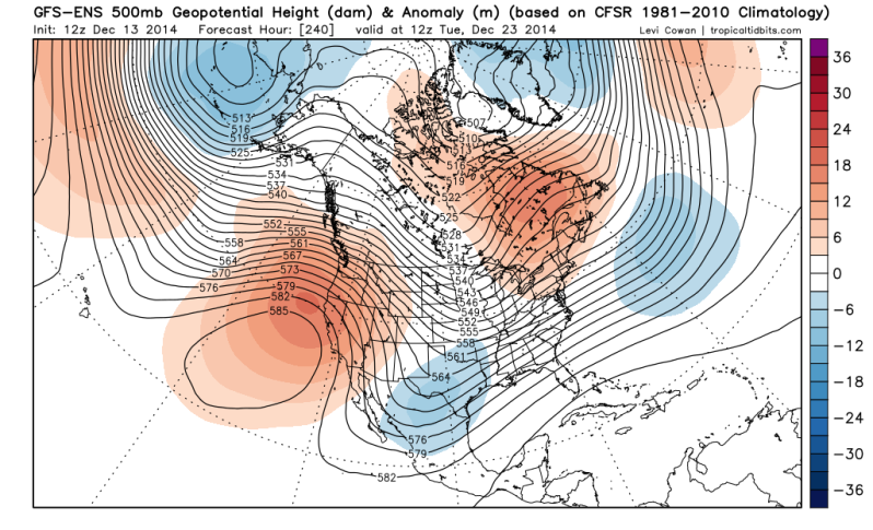
orangeblood wrote:Most every models Ensemble Mean are in agreement now that we will see much colder pattern change, occurring shortly after Christmas. Something that has been discussed on here for a few weeks now and we're finally seeing model agreement....
Euro ENS
http://models.weatherbell.com/ecmwf/201 ... mer_61.png
Canadian ENS
http://models.weatherbell.com/gefs/2014 ... mer_61.png
GFS ENS
http://models.weatherbell.com/gefs/2014 ... mer_61.png

orangeblood wrote::uarrow: To me, it appears to be that the extremely cold air over Siberia is forecast to flood the northwest Pacific and overwhelm the Pacific pattern...this will intensify the Pacific jet and Aleutian Low, pumping the ridge into Alaska with downstream implications into our neighborhood

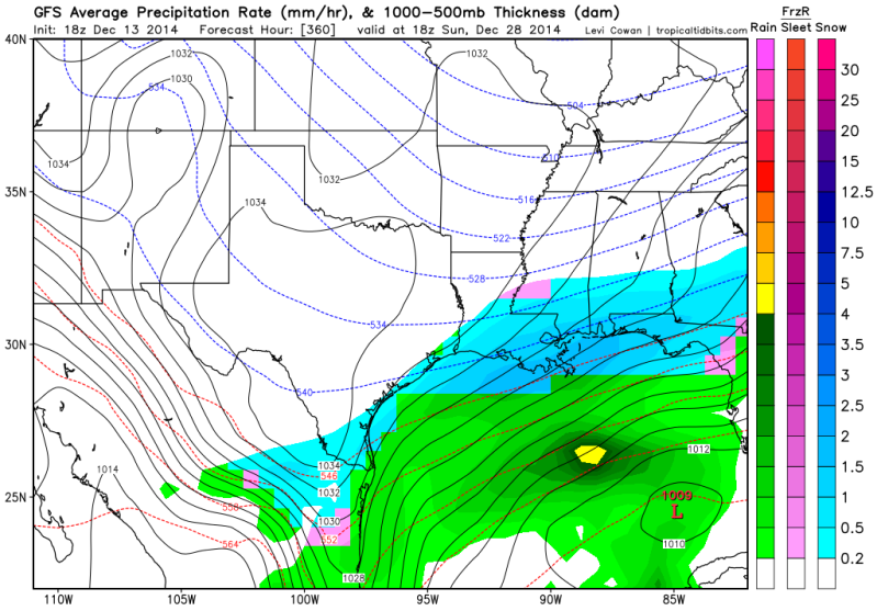
Portastorm wrote:Heh, our friend Rgv20 is going to like the late part of the 18z GFS op run. Shows sleet or freezing rain in parts of the Valley at 348 hours.

asd123 wrote:Portastorm wrote:Heh, our friend Rgv20 is going to like the late part of the 18z GFS op run. Shows sleet or freezing rain in parts of the Valley at 348 hours.
Yeah it will make for a great discussion; bitterly cold forecast from the GFS, yet hostile teleconnections?
Portastorm wrote:asd123 wrote:Portastorm wrote:Heh, our friend Rgv20 is going to like the late part of the 18z GFS op run. Shows sleet or freezing rain in parts of the Valley at 348 hours.
Yeah it will make for a great discussion; bitterly cold forecast from the GFS, yet hostile teleconnections?
I understand what you're saying and agree that the current progged teleconnections don't quite add up. But when just about every well-known nationally followed pro met online believes we'll see big changes late month and now the ensembles and even operational models are following suit, how can you dismiss that? Something has to give.
 ) I personally see the models and ensembles are forecasting a shift towards colder weather. What I completely don't understand is why the teleconnections are so hostile towards cold for the South, Southeast, and Florida, yet the models and ensembles are forecasting cold.


Portastorm wrote:Heh, our friend Rgv20 is going to like the late part of the 18z GFS op run. Shows sleet or freezing rain in parts of the Valley at 348 hours.

Users browsing this forum: No registered users and 51 guests