2015 Global model runs discussion
Moderator: S2k Moderators
Forum rules

The posts in this forum are NOT official forecasts and should not be used as such. They are just the opinion of the poster and may or may not be backed by sound meteorological data. They are NOT endorsed by any professional institution or STORM2K. For official information, please refer to products from the National Hurricane Center and National Weather Service.
-
Stormcenter
- S2K Supporter

- Posts: 6689
- Joined: Wed Sep 03, 2003 11:27 am
- Location: Houston, TX


Lets stick to strictly model runs in here, all other discussions lets keep them in their respective threads as has been derailed quite a bit. Conditions or lack-thereof can be talked about in Atlantic indicators thread, we can talk about what years where what in the ENSO thread  .
.
Back on topic Mid to late July with semblance of a weaker version MJO should ignite some activity in the models as noted by Hammy. I would focus on the Gulf first for something in close.
Back on topic Mid to late July with semblance of a weaker version MJO should ignite some activity in the models as noted by Hammy. I would focus on the Gulf first for something in close.
0 likes
The above post and any post by Ntxw is NOT an official forecast and should not be used as such. It is just the opinion of the poster and may or may not be backed by sound meteorological data. It is NOT endorsed by any professional institution including Storm2k. For official information, please refer to NWS products.
Help support Storm2K!


GFS long range is showing a low off of Florida in the same vicinity and general time frame as the British CFS has been showing for some time.
0 likes
The above post is not official and should not be used as such. It is the opinion of the poster and may or may not be backed by sound meteorological data. It is not endorsed by any professional institution or storm2k.org. For official information, please refer to the NHC and NWS products.
True to El Nino, and following what I saw a few people here speculating weeks ago, the latest Euro develops two systems off the East Coast in the next week, including one possibly near hurricane intensity.
0 likes
The above post is not official and should not be used as such. It is the opinion of the poster and may or may not be backed by sound meteorological data. It is not endorsed by any professional institution or storm2k.org. For official information, please refer to the NHC and NWS products.

Re: 2015 Global model runs discussion
What's this about a model run suggesting a full blown cane hitting the Texas coast??? My local Promet mentioned it last night, but made no model reference, and discounted it saying its too far out??? The Truth Is Out There my weather friends. But it is not on our glomodels run page!!!! Anyone?
I Want To Believe.

I Want To Believe.
0 likes

Re: 2015 Global model runs discussion
Some of the other models are hinting at some weak development but they all seem to kill it off before it reaches the islands. Shear monster probably
time sensetive

time sensetive
0 likes
The following post is NOT an official forecast and should not be used as such. It is just the opinion of the poster and may or may not be backed by sound meteorological data. It is NOT endorsed by any professional institution including storm2k.org For Official Information please refer to the NHC and NWS products.
-
tolakram
- Admin

- Posts: 20186
- Age: 62
- Joined: Sun Aug 27, 2006 8:23 pm
- Location: Florence, KY (name is Mark)
Re: 2015 Global model runs discussion
TexasF6 wrote:What's this about a model run suggesting a full blown cane hitting the Texas coast??? My local Promet mentioned it last night, but made no model reference, and discounted it saying its too far out??? The Truth Is Out There my weather friends. But it is not on our glomodels run page!!!! Anyone?
I Want To Believe.
Euro out to 240 shows nothing, and without a source we have nothing to go on. I would change the channel.
0 likes
M a r k
- - - - -
Join us in chat: Storm2K Chatroom Invite. Android and IOS apps also available.
The posts in this forum are NOT official forecasts and should not be used as such. Posts are NOT endorsed by any professional institution or STORM2K.org. For official information and forecasts, please refer to NHC and NWS products.
-
gatorcane

- S2K Supporter
- Posts: 23708
- Age: 48
- Joined: Sun Mar 13, 2005 3:54 pm
- Location: Boca Raton, FL
The ECMWF shows the low moving off Africa but slightly slower than the GFS and more to the south, graphic below.
So both GFS and ECMWF are showing a vigorous wave with attached low moving off Africa in around a week. Something to watch as we edge closer to the start of the Cape Verde season.

12Z GFS 10 day below for comparison:

So both GFS and ECMWF are showing a vigorous wave with attached low moving off Africa in around a week. Something to watch as we edge closer to the start of the Cape Verde season.
12Z GFS 10 day below for comparison:
0 likes


Re: 2015 Global model runs discussion
We have a storm about to hit us (Biloxi) that is coming from the east to west. With the storminess in the south and east to Florida, is that conducive? Can tornados spin up in a storm moving east to west?
0 likes
Re: 2015 Global model runs discussion
HeeBGBz wrote:We have a storm about to hit us (Biloxi) that is coming from the east to west. With the storminess in the south and east to Florida, is that conducive? Can tornados spin up in a storm moving east to west?
Yes HeeBGBz, tornadoes can spin up from a storm system moving from East to West, if conditions are favorable. This thread is generally a models thread, so I would recommend checking out Deep South Wx forum, or check for threads on your question if there are any. If an old cold front sits in the GOM long it enough? It can form into a tropical entity. But model support for this feature is nil so far.....and the storms have fizzled with dusk it seems. Hope this helps!

0 likes
Re: 2015 Global model runs discussion
Yes, thanks for the info. I sometimes have problems reading the run maps on my phone.
0 likes
-
cycloneye

- Admin
- Posts: 149514
- Age: 69
- Joined: Thu Oct 10, 2002 10:54 am
- Location: San Juan, Puerto Rico
Re: 2015 Global model runs discussion
The trend of homegrown ones in 2015 may continue if 00z ECMWF is right.

0 likes
Visit the Caribbean-Central America Weather Thread where you can find at first post web cams,radars
and observations from Caribbean basin members Click Here
and observations from Caribbean basin members Click Here


Re: 2015 Global model runs discussion
Very interesting run by the Euro last night as mentioned above, now wait and see on consistency.
BTW, it shows for development off of FL east coast by next Sunday then quickly gain strength.
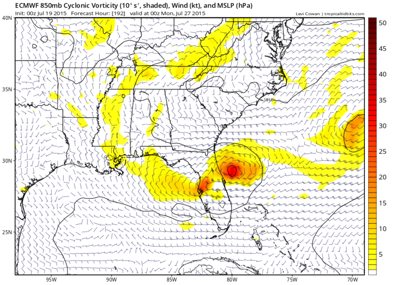
BTW, it shows for development off of FL east coast by next Sunday then quickly gain strength.

0 likes
-
srainhoutx

- S2K Supporter
- Posts: 6919
- Age: 68
- Joined: Sun Jan 14, 2007 11:34 am
- Location: Haywood County, NC
- Contact:
Re: 2015 Global model runs discussion
The Extended Range Forecast from the WPC mentions the area off the SE Coast for potential development of a weak surface low so it may be worth monitoring. The SE has been a 'favored' area for potential tropical development this season and a stalled boundary and the potential for a MCV rolling across the Plains into the SE around the 'Ring of Fire' upper ridge parked over Texas does merit attention.
...MODEL EVALUATION/PREFERENCES...
MODELS ARE IN VERY GOOD AGREEMENT WITH THE LARGE SCALE FLOW
PATTERN SETTING UP OVER THE LOWER 48 TOWARDS THE MIDDLE OF NEXT
WEEK AND HEADING INTO THE WEEKEND...BUT THERE IS STILL A SMALL
AMOUNT OF SPREAD WITH SOME OF THE SMALLER SCALE DETAILS. THE
BIGGEST FLUCTUATIONS AND UNCERTAINTY IN THE FORECAST APPEAR TO BE
WITH THE EVOLUTION OF REMNANT ENERGY FROM TROPICAL SYSTEM DOLORES
LIFTING OUT OF THE GREAT BASIN ON WEDNESDAY...THE EXACT TIMING AND
STRENGTH OF THE COLD FRONT PUSHING OUT ACROSS THE NORTHERN PLAINS
AND UPPER MIDWEST FRIDAY AND SATURDAY...AND THE DEVELOPMENT OF A
WEAK SURFACE LOW POSSIBLY SPINNING UP ALONG THE FRONTAL BOUNDARY
LINGERING OVER THE SOUTHEAST. CONSIDERING THE SPREAD IN THE
DETAILS OF DETERMINISTIC GUIDANCE...THE WPC DAY 3-7 FORECAST
RELIED ON THE AGREEABLE AND STABLE GEFS/ECWMF ENSEMBLE MEANS.
0 likes
Carla/Alicia/Jerry(In The Eye)/Michelle/Charley/Ivan/Dennis/Katrina/Rita/Wilma/Ike/Harvey
Member: National Weather Association
Wx Infinity Forums
http://wxinfinity.com/index.php
Facebook.com/WeatherInfinity
Twitter @WeatherInfinity
Member: National Weather Association
Wx Infinity Forums
http://wxinfinity.com/index.php
Facebook.com/WeatherInfinity
Twitter @WeatherInfinity
-
wxman57

- Moderator-Pro Met

- Posts: 23175
- Age: 68
- Joined: Sat Jun 21, 2003 8:06 pm
- Location: Houston, TX (southwest)
Re: 2015 Global model runs discussion
Look off the East U.S. Coast for the next storm, not in the tropics.
0 likes
-
gatorcane
- S2K Supporter
- Posts: 23708
- Age: 48
- Joined: Sun Mar 13, 2005 3:54 pm
- Location: Boca Raton, FL
Wxman yes, the place to look in the next 7-10 days is off the SE U.S coast.
Still there looks to be quite an impressive wave the EC and GFS are showing rolls off the African coast in about 5 days from now. GFS shows a closed low making it almost all the way across the Leewards before fizzling out in the long rate (288 hours).
It seems the waves are getting stronger and stronger as time goes on. Probably in about 3-4 weeks, we will need to really start looking out the Atlantic between the Leewards and Africa:
0 likes
-
TheStormExpert
Re: 2015 Global model runs discussion
NDG wrote:Very interesting run by the Euro last night as mentioned above, now wait and see on consistency.
BTW, it shows for development off of FL east coast by next Sunday then quickly gain strength.
If this holds, it would be almost identical to Arthur's genesis last year, which was very well forecast by the Euro quite a ways out.
0 likes
The above post is not official and should not be used as such. It is the opinion of the poster and may or may not be backed by sound meteorological data. It is not endorsed by any professional institution or storm2k.org. For official information, please refer to the NHC and NWS products.
Who is online
Users browsing this forum: RomP and 131 guests