Another area of low pressure could form early next week well to the
south-southwest of the southern tip of the Baja California
peninsula. Environmental conditions appear to be conducive for slow
development of this system.
* Formation chance through 48 hours...low...near 0 percent
* Formation chance through 5 days...low...30 percent
2015 EPAC Season
Moderator: S2k Moderators
Forum rules

The posts in this forum are NOT official forecasts and should not be used as such. They are just the opinion of the poster and may or may not be backed by sound meteorological data. They are NOT endorsed by any professional institution or STORM2K. For official information, please refer to products from the National Hurricane Center and National Weather Service.
-
Yellow Evan

- Professional-Met

- Posts: 16211
- Age: 27
- Joined: Fri Jul 15, 2011 12:48 pm
- Location: Henderson, Nevada/Honolulu, HI
- Contact:
-
Yellow Evan
- Professional-Met
- Posts: 16211
- Age: 27
- Joined: Fri Jul 15, 2011 12:48 pm
- Location: Henderson, Nevada/Honolulu, HI
- Contact:
Showers and thunderstorms located several hundred miles south of the
southern tip of the Baja California peninsula are associated with a
westward-moving tropical wave. Environmental conditions could be
conducive for slow development of this system later this week.
* Formation chance through 48 hours...low...near 0 percent
* Formation chance through 5 days...low...30 percent
0 likes
-
cycloneye

- Admin

- Posts: 148721
- Age: 69
- Joined: Thu Oct 10, 2002 10:54 am
- Location: San Juan, Puerto Rico
Re: 2015 EPAC Season
Yellow Evan,do you think EPAC is underperforming as things haved slowed down in the ACE department with no strong Hurricanes after the great start of strong hurricanes?
0 likes
Visit the Caribbean-Central America Weather Thread where you can find at first post web cams,radars
and observations from Caribbean basin members Click Here
and observations from Caribbean basin members Click Here
-
Yellow Evan
- Professional-Met
- Posts: 16211
- Age: 27
- Joined: Fri Jul 15, 2011 12:48 pm
- Location: Henderson, Nevada/Honolulu, HI
- Contact:
Re: 2015 EPAC Season
cycloneye wrote:Yellow Evan,do you think EPAC is underperforming as things haved slowed down in the ACE department with no strong Hurricanes after the great start of strong hurricanes?
Not really underperforming as this has been a feast or famine year as most El Nino years are. I think with the warm SST's out there, late August/September can be a very prime time for hurricanes and major hurricanes.
While we've gotten a few too many weak storms for my liking, I'm not overly concerned. Learned my lesson last year.
0 likes
-
CaliforniaResident
- Tropical Storm

- Posts: 215
- Joined: Fri Feb 21, 2014 1:47 pm
Re: 2015 EPAC Season
Yellow Evan wrote:cycloneye wrote:Yellow Evan,do you think EPAC is underperforming as things haved slowed down in the ACE department with no strong Hurricanes after the great start of strong hurricanes?
Not really underperforming as this has been a feast or famine year as most El Nino years are. I think with the warm SST's out there, late August/September can be a very prime time for hurricanes and major hurricanes.
While we've gotten a few too many weak storms for my liking, I'm not overly concerned. Learned my lesson last year.
The SST off of San Diego hit 76 this weekend. When the remnants of Dolores affected us, the SST were only in the low 70s. By September, parts of our coastline could hit that elusive 80 degree month (September is our warmest month both on land and in water). All it would take is a similar track to Dolores in late September and October and an early season fall trough to push the storm inland and you have a recipe for a repeat of something like this:
https://en.wikipedia.org/wiki/1858_San_Diego_hurricane
0 likes
-
Yellow Evan
- Professional-Met
- Posts: 16211
- Age: 27
- Joined: Fri Jul 15, 2011 12:48 pm
- Location: Henderson, Nevada/Honolulu, HI
- Contact:
Re: 2015 EPAC Season
CaliforniaResident wrote:Yellow Evan wrote:cycloneye wrote:Yellow Evan,do you think EPAC is underperforming as things haved slowed down in the ACE department with no strong Hurricanes after the great start of strong hurricanes?
Not really underperforming as this has been a feast or famine year as most El Nino years are. I think with the warm SST's out there, late August/September can be a very prime time for hurricanes and major hurricanes.
While we've gotten a few too many weak storms for my liking, I'm not overly concerned. Learned my lesson last year.
The SST off of San Diego hit 76 this weekend. When the remnants of Dolores affected us, the SST were only in the low 70s. By September, parts of our coastline could hit that elusive 80 degree month (September is our warmest month both on land and in water). All it would take is a similar track to Dolores in late September and October and an early season fall trough to push the storm inland and you have a recipe for a repeat of something like this:
https://en.wikipedia.org/wiki/1858_San_Diego_hurricane
Yes, but SST's are colder the further you get out and likely won't reach 26C. If a TC were to make it, it'd have to cross waters of 22-23C. Not impossible, but still not too likely.
Not sure if the 1858 San Diego hurricane was an actual hurricane.
0 likes
-
Yellow Evan
- Professional-Met
- Posts: 16211
- Age: 27
- Joined: Fri Jul 15, 2011 12:48 pm
- Location: Henderson, Nevada/Honolulu, HI
- Contact:
Showers and thunderstorms associated with a tropical wave located
several hundred miles south of the southern tip of the Baja
California peninsula have increased since yesterday. Environmental
conditions are forecast to be conducive for slow development while
the disturbance moves generally westward this week.
* Formation chance through 48 hours...low...near 0 percent
* Formation chance through 5 days...medium...40 percent
0 likes
-
cycloneye
- Admin
- Posts: 148721
- Age: 69
- Joined: Thu Oct 10, 2002 10:54 am
- Location: San Juan, Puerto Rico
Re: 2015 EPAC Season
A tropical wave located several hundred miles south of the southern
tip of the Baja California peninsula continues to produce a large
area of cloudiness and disorganized shower activity. Environmental
conditions are forecast to be conducive for slow development while
the disturbance moves generally westward this week.
* Formation chance through 48 hours...low...near 0 percent
* Formation chance through 5 days...medium...50 percent
0 likes
Visit the Caribbean-Central America Weather Thread where you can find at first post web cams,radars
and observations from Caribbean basin members Click Here
and observations from Caribbean basin members Click Here
-
Yellow Evan
- Professional-Met
- Posts: 16211
- Age: 27
- Joined: Fri Jul 15, 2011 12:48 pm
- Location: Henderson, Nevada/Honolulu, HI
- Contact:


-
cycloneye
- Admin
- Posts: 148721
- Age: 69
- Joined: Thu Oct 10, 2002 10:54 am
- Location: San Juan, Puerto Rico
Re: 2015 EPAC Season
0 likes
Visit the Caribbean-Central America Weather Thread where you can find at first post web cams,radars
and observations from Caribbean basin members Click Here
and observations from Caribbean basin members Click Here
-
Kingarabian

- S2K Supporter

- Posts: 16294
- Joined: Sat Aug 08, 2009 3:06 am
- Location: Honolulu, Hawaii
Just got back to Hawaii and I can finally take part in conversations again.
(@Yellow Evan, 3 big Vegas basketball tournaments loaded with D1 prospects and future NBA players! I'm a basketball fanatic myself. Go Lakers!)
EPAC looks to be favorable for development for the rest of the month. Especially with that big WWB rolling.
(@Yellow Evan, 3 big Vegas basketball tournaments loaded with D1 prospects and future NBA players! I'm a basketball fanatic myself. Go Lakers!)
EPAC looks to be favorable for development for the rest of the month. Especially with that big WWB rolling.
0 likes
RIP Kobe Bryant
-
Yellow Evan
- Professional-Met
- Posts: 16211
- Age: 27
- Joined: Fri Jul 15, 2011 12:48 pm
- Location: Henderson, Nevada/Honolulu, HI
- Contact:
Re:
Kingarabian wrote:Just got back to Hawaii and I can finally take part in conversations again.
(@Yellow Evan, 3 big Vegas basketball tournaments loaded with D1 prospects and future NBA players! I'm a basketball fanatic myself. Go Lakers!)
EPAC looks to be favorable for development for the rest of the month. Especially with that big WWB rolling.
Neat.
But anyway, EPAC looks like it's in high gear. We'll have the best possible comdination. A CCKW,followed by MJO, then likely more MJO after it gets back on track. We'll be busy for quite some time and I think we could be dealing with stronger storms this time around.
CFS and CFS ensemble are in perfect agreement on this.

Here is the 16 day 18z GFS run:
0 likes
-
Yellow Evan
- Professional-Met
- Posts: 16211
- Age: 27
- Joined: Fri Jul 15, 2011 12:48 pm
- Location: Henderson, Nevada/Honolulu, HI
- Contact:

-
Yellow Evan
- Professional-Met
- Posts: 16211
- Age: 27
- Joined: Fri Jul 15, 2011 12:48 pm
- Location: Henderson, Nevada/Honolulu, HI
- Contact:

-
Yellow Evan
- Professional-Met
- Posts: 16211
- Age: 27
- Joined: Fri Jul 15, 2011 12:48 pm
- Location: Henderson, Nevada/Honolulu, HI
- Contact:


-
Yellow Evan
- Professional-Met
- Posts: 16211
- Age: 27
- Joined: Fri Jul 15, 2011 12:48 pm
- Location: Henderson, Nevada/Honolulu, HI
- Contact:

-
srainhoutx

- S2K Supporter
- Posts: 6919
- Age: 68
- Joined: Sun Jan 14, 2007 11:34 am
- Location: Haywood County, NC
- Contact:
Re: 2015 EPAC Season
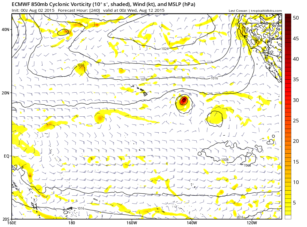
The ECMWF has been very suggestive the past several runs of yet another EPAC Hurricane developing and moving WNW eventually shifting to the Central Pacific and posing a possible threat to Hawaii.
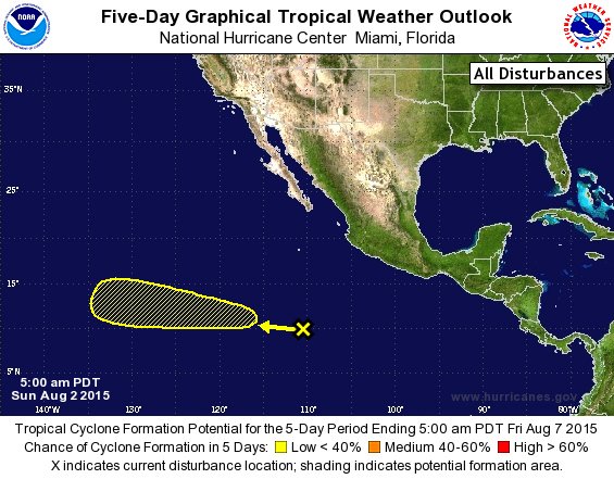
TROPICAL WEATHER OUTLOOK
NWS NATIONAL HURRICANE CENTER MIAMI FL
500 AM PDT SUN AUG 2 2015
For the eastern North Pacific...east of 140 degrees west longitude:
1. An area of disturbed weather associated with a tropical wave is
located about 900 miles south of the southern tip of the Baja
California peninsula. Environmental conditions are expected to be
somewhat conducive for slow development of this system this week as
it moves west-northwestward at 10 to 15 mph.
* Formation chance through 48 hours...low...near 0 percent
* Formation chance through 5 days...low...20 percent
Forecaster Kimberlain
0 likes
Carla/Alicia/Jerry(In The Eye)/Michelle/Charley/Ivan/Dennis/Katrina/Rita/Wilma/Ike/Harvey
Member: National Weather Association
Wx Infinity Forums
http://wxinfinity.com/index.php
Facebook.com/WeatherInfinity
Twitter @WeatherInfinity
Member: National Weather Association
Wx Infinity Forums
http://wxinfinity.com/index.php
Facebook.com/WeatherInfinity
Twitter @WeatherInfinity
-
Yellow Evan
- Professional-Met
- Posts: 16211
- Age: 27
- Joined: Fri Jul 15, 2011 12:48 pm
- Location: Henderson, Nevada/Honolulu, HI
- Contact:
A tropical wave located about 950 miles south-southwest of the
southern tip of the Baja California peninsula is producing
disorganized showers and thunderstorms. Environmental conditions
are expected to be conducive for gradual development of this
system later this week as it moves west-northwestward at 10 to
15 mph.
* Formation chance through 48 hours...low...near 0 percent
* Formation chance through 5 days...low...30 percent
0 likes
-
Kingarabian
- S2K Supporter
- Posts: 16294
- Joined: Sat Aug 08, 2009 3:06 am
- Location: Honolulu, Hawaii
Who is online
Users browsing this forum: No registered users and 63 guests