Weak low in NE Gulf of Mexico: (Is Invest 95L)

This is the general tropical discussion area. Anyone can take their shot at predicting a storms path.

Moderator: S2k Moderators

Forum rules

The posts in this forum are NOT official forecasts and should not be used as such. They are just the opinion of the poster and may or may not be backed by sound meteorological data. They are NOT endorsed by any professional institution or STORM2K. For official information, please refer to products from the National Hurricane Center and National Weather Service.

Help Support Storm2K
Message
Author
User avatar
NDG
S2K Supporter
S2K Supporter
Posts: 15446
Joined: Sun Jul 09, 2006 10:14 pm
Location: Orlando, FL

#621 Postby NDG » Sun Aug 02, 2015 6:09 pm

What a difference 6 hrs make. Around noon we were looking at a low level naked swirl, now deep convection is near the COC.

Image
Image
0 likes   

User avatar
tropicwatch
Category 5
Category 5
Posts: 3386
Age: 61
Joined: Sat Jun 02, 2007 10:01 am
Location: Panama City Florida
Contact:

#622 Postby tropicwatch » Sun Aug 02, 2015 6:10 pm

I think the models have been out to lunch a little bit :double:
0 likes   
Tropicwatch


Agnes 72', Eloise 75, Elena 85', Kate 85', Charley 86', Florence 88', Beryl 94', Dean 95', Erin 95', Opal 95', Earl 98', Georges 98', Ivan 2004', Arlene 2005', Dennis 2005', Ida 2009' Debby 2012' Irma 2017' Michael 2018'

tolakram
Admin
Admin
Posts: 20009
Age: 62
Joined: Sun Aug 27, 2006 8:23 pm
Location: Florence, KY (name is Mark)

Re: Weak low in NE Gulf of Mexico

#623 Postby tolakram » Sun Aug 02, 2015 6:11 pm

Saved radar loop from today

Image
0 likes   
M a r k
- - - - -
Join us in chat: Storm2K Chatroom Invite. Android and IOS apps also available.

The posts in this forum are NOT official forecasts and should not be used as such. Posts are NOT endorsed by any professional institution or STORM2K.org. For official information and forecasts, please refer to NHC and NWS products.

User avatar
northjaxpro
S2K Supporter
S2K Supporter
Posts: 8900
Joined: Mon Sep 27, 2010 11:21 am
Location: Jacksonville, FL

Re:

#624 Postby northjaxpro » Sun Aug 02, 2015 6:12 pm

hurricanekid416 wrote:So how much time does it have on water
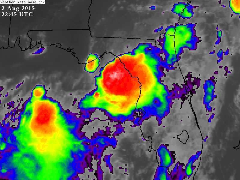

Well, to everyone's surprise the Low drifted into Apalachee Bay on a very slow south/southeast drift very early today, and has maintained that drift all day long. The system has stayed over water all day and now even is drifting more due south the past couple of hours. The forecast was for the system to get pulled northeast, but to this point obviously that has not happened.

If the southerly drift continues through the night, this will I think be classified at the very least as a TD. It also could drift south to a point where it can get a bit farther offshore as well. It was drifting almost identically parallel the Big Bend coast on a south/southeast header, almost hugging against it actually. But, a more southward drift could get the system a bit farther out over the water. A very interesting evening tonight monitoring this feature. It is definitely organizing and I am wondering what other surprises this system is trying to pull on us?
Last edited by northjaxpro on Sun Aug 02, 2015 6:13 pm, edited 1 time in total.
0 likes   
NEVER, EVER SAY NEVER in the tropics and weather in general, and most importantly, with life itself!!

________________________________________________________________________________________

Fay 2008 Beryl 2012 Debby 2012 Colin 2016 Hermine 2016 Julia 2016 Matthew 2016 Irma 2017 Dorian 2019

TheStormExpert

Re: Re:

#625 Postby TheStormExpert » Sun Aug 02, 2015 6:13 pm

Dean4Storms wrote:
Stormcenter wrote:I agree


TheStormExpert wrote:Is it me or does it look to be less definable on radar?


Looks that way because Convection has fired over the center, you don't see the little bands spiraling around a hole so easily now.

After looking at the radar a few more times I have to agree with you.
0 likes   

TheStormExpert

Re: Weak low in NE Gulf of Mexico

#626 Postby TheStormExpert » Sun Aug 02, 2015 6:15 pm

tolakram wrote:Saved radar loop from today

Image

That southern side rain band doesn't look as curved as before.
0 likes   

lovingseason2013
Tropical Depression
Tropical Depression
Posts: 71
Joined: Sat Oct 12, 2013 7:54 am
Location: Pensacola, FL

Re: Weak low in NE Gulf of Mexico

#627 Postby lovingseason2013 » Sun Aug 02, 2015 6:17 pm

So what is the thinking on where the low is moving? Is it going out to the gulf, inshore somewhere? Is there any model support, and is there any chance SE Florida can get some rain from this as it has been so dry!
0 likes   

Dean4Storms
S2K Supporter
S2K Supporter
Posts: 6358
Age: 62
Joined: Sun Aug 31, 2003 1:01 pm
Location: Miramar Bch. FL

Re: Weak low in NE Gulf of Mexico

#628 Postby Dean4Storms » Sun Aug 02, 2015 6:20 pm

TheStormExpert wrote:
tolakram wrote:Saved radar loop from today

Image

That southern side rain band doesn't look as curved as before.


Something that should be pointed out looking at a radar depiction in this scenario where the shear from the North being still pretty strong. The circulation is likely tilted, in other words what we see as the circulation on radar at around 5K feet is likely a bit further to the South of the surface circulation. This is still a sheared system.
0 likes   

User avatar
NDG
S2K Supporter
S2K Supporter
Posts: 15446
Joined: Sun Jul 09, 2006 10:14 pm
Location: Orlando, FL

#629 Postby NDG » Sun Aug 02, 2015 6:22 pm

This is some nice inflow. this buoy is reporting, into the storms near the COC.

Conditions at 42036 as of
(5:50 pm CDT)
2250 GMT on 08/02/2015:
Unit of Measure: Time Zone:
Click on the graph icon in the table below to see a time series plot of the last five days of that observation.

5-day plot - Wind Direction Wind Direction (WDIR): WSW ( 250 deg true )
5-day plot - Wind Speed Wind Speed (WSPD): 27.2 kts
5-day plot - Wind Gust Wind Gust (GST): 33.0 kts
5-day plot - Wave Height Wave Height (WVHT): 9.2 ft
5-day plot - Dominant Wave Period Dominant Wave Period (DPD): 8 sec
5-day plot - Average Period Average Period (APD): 6.0 sec
5-day plot - Mean Wave Direction Mean Wave Direction (MWD): SW ( 230 deg true )
5-day plot - Atmospheric Pressure Atmospheric Pressure (PRES): 29.79 in
5-day plot - Pressure Tendency Pressure Tendency (PTDY): -0.04 in ( Falling )
5-day plot - Air Temperature Air Temperature (ATMP): 81.5 °F
5-day plot - Water Temperature Water Temperature (WTMP): 84.4 °F
5-day plot - Dew Point Dew Point (DEWP): 78.8 °F
5-day plot - Heat Index Heat Index (HEAT): 90.3 °F
5-day plot - Wind Speed at 10 Meters Wind Speed at 10 meters (WSPD10M): 29.1 kts
5-day plot - Wind Speed at 10 Meters Wind Speed at 20 meters (WSPD20M): 31.1 kts

http://www.ndbc.noaa.gov/station_page.php?station=42036
0 likes   

User avatar
NDG
S2K Supporter
S2K Supporter
Posts: 15446
Joined: Sun Jul 09, 2006 10:14 pm
Location: Orlando, FL

Re: Weak low in NE Gulf of Mexico

#630 Postby NDG » Sun Aug 02, 2015 6:24 pm

Dean4Storms wrote:
TheStormExpert wrote:
tolakram wrote:Saved radar loop from today

http://imageshack.com/a/img538/1231/uW8MNZ.gif

That southern side rain band doesn't look as curved as before.


Something that should be pointed out looking at a radar depiction in this scenario where the shear from the North being still pretty strong. The circulation is likely tilted, in other words what we see as the circulation on radar at around 5K feet is likely a bit further to the South of the surface circulation. This is still a sheared system.


Yeah I agree, and it could be that the mid level circulation is starting to get sheared away once again towards the south because looking at surface reports the surface COC has not moved that far south yet.
0 likes   

User avatar
northjaxpro
S2K Supporter
S2K Supporter
Posts: 8900
Joined: Mon Sep 27, 2010 11:21 am
Location: Jacksonville, FL

#631 Postby northjaxpro » Sun Aug 02, 2015 6:25 pm

Yeah, shear is still present, but not the crippling shear we had been seeing all this past week currently. The shear has let up enough for this Low to wrap up a bit these past 6 hours.
0 likes   
NEVER, EVER SAY NEVER in the tropics and weather in general, and most importantly, with life itself!!

________________________________________________________________________________________

Fay 2008 Beryl 2012 Debby 2012 Colin 2016 Hermine 2016 Julia 2016 Matthew 2016 Irma 2017 Dorian 2019

User avatar
tropicwatch
Category 5
Category 5
Posts: 3386
Age: 61
Joined: Sat Jun 02, 2007 10:01 am
Location: Panama City Florida
Contact:

#632 Postby tropicwatch » Sun Aug 02, 2015 6:27 pm

Close to TD status.
0 likes   
Tropicwatch


Agnes 72', Eloise 75, Elena 85', Kate 85', Charley 86', Florence 88', Beryl 94', Dean 95', Erin 95', Opal 95', Earl 98', Georges 98', Ivan 2004', Arlene 2005', Dennis 2005', Ida 2009' Debby 2012' Irma 2017' Michael 2018'

psyclone
S2K Supporter
S2K Supporter
Posts: 4762
Joined: Wed Aug 24, 2005 9:04 pm
Location: palm harbor fl

#633 Postby psyclone » Sun Aug 02, 2015 6:31 pm

FWIW the winds have reduced here as compared to earlier this afternoon.
0 likes   

User avatar
SouthDadeFish
Professional-Met
Professional-Met
Posts: 2835
Joined: Thu Sep 23, 2010 2:54 pm
Location: Miami, FL
Contact:

#634 Postby SouthDadeFish » Sun Aug 02, 2015 6:33 pm

Folks, keep in mind one of the conditions necessary for classification as a tropical cyclone is persistent, organized convection. As some of you pointed out, the swirl was devoid of convection earlier today. If convection persists overnight, then we could be debating if this is a TC or not. Nonetheless, quite an interesting feature. Continues to look better organized in my opinion.
0 likes   

User avatar
NDG
S2K Supporter
S2K Supporter
Posts: 15446
Joined: Sun Jul 09, 2006 10:14 pm
Location: Orlando, FL

Re:

#635 Postby NDG » Sun Aug 02, 2015 6:33 pm

northjaxpro wrote:Yeah, shear is still present, but not the crippling shear we had been seeing all this past week currently. The shear has let up enough for this Low to wrap up a bit these past 6 hours.


I can't wait to see the sounding from TPA and TLH at 0z,
0 likes   

TheStormExpert

#636 Postby TheStormExpert » Sun Aug 02, 2015 6:36 pm

Seriously!?


000
ABNT20 KNHC 022332
TWOAT

TROPICAL WEATHER OUTLOOK
NWS NATIONAL HURRICANE CENTER MIAMI FL
800 PM EDT SUN AUG 2 2015

For the North Atlantic...Caribbean Sea and the Gulf of Mexico:

A weak area of low pressure located along the coast of the Florida
Big Bend is producing disorganized shower and thunderstorm activity
across portions of northern Florida and the extreme northeastern
Gulf of Mexico. Upper-level winds are not expected to be conducive
for development while the low moves northeastward at 5 to 10 mph
across north Florida and near the southeastern United States coast
during the next few days. Regardless of development, this system is
expected to produce heavy rainfall across portions of northern
Florida tonight and Monday. For additional information on rainfall
associated with this system, refer to products from your local
National Weather Service forecast office.
* Formation chance through 48 hours...low...10 percent
* Formation chance through 5 days...low...10 percent

$$
Forecaster Brennan
0 likes   

User avatar
Hammy
Category 5
Category 5
Posts: 5849
Age: 41
Joined: Fri May 25, 2012 5:25 pm
Contact:

#637 Postby Hammy » Sun Aug 02, 2015 6:37 pm

If this continues to organize, wouldn't it go with the upper flow and be pushed inland before it can develop?
0 likes   
The above post is not official and should not be used as such. It is the opinion of the poster and may or may not be backed by sound meteorological data. It is not endorsed by any professional institution or storm2k.org. For official information, please refer to the NHC and NWS products.

psyclone
S2K Supporter
S2K Supporter
Posts: 4762
Joined: Wed Aug 24, 2005 9:04 pm
Location: palm harbor fl

Re:

#638 Postby psyclone » Sun Aug 02, 2015 6:38 pm

SouthDadeFish wrote:Folks, keep in mind one of the conditions necessary for classification as a tropical cyclone is persistent, organized convection. As some of you pointed out, the swirl was devoid of convection earlier today. If convection persists overnight, then we could be debating if this is a TC or not. Nonetheless, quite an interesting feature. Continues to look better organized in my opinion.

I concur on all points. We lack the persistence the NHC wisely looks for.
0 likes   

User avatar
northjaxpro
S2K Supporter
S2K Supporter
Posts: 8900
Joined: Mon Sep 27, 2010 11:21 am
Location: Jacksonville, FL

#639 Postby northjaxpro » Sun Aug 02, 2015 6:39 pm

Wow, NHC not recognizing the southward drift. Interesting. Also I would have upped the percentages. Just my opinion.
Last edited by northjaxpro on Sun Aug 02, 2015 6:40 pm, edited 1 time in total.
0 likes   
NEVER, EVER SAY NEVER in the tropics and weather in general, and most importantly, with life itself!!

________________________________________________________________________________________

Fay 2008 Beryl 2012 Debby 2012 Colin 2016 Hermine 2016 Julia 2016 Matthew 2016 Irma 2017 Dorian 2019

User avatar
JKingTampa
Tropical Storm
Tropical Storm
Posts: 101
Joined: Wed Sep 10, 2014 8:16 pm
Location: St. Petersburg, FL

#640 Postby JKingTampa » Sun Aug 02, 2015 6:40 pm

I'm not seeing the slightest northeast movement, but again that's just me...
0 likes   


Return to “Talkin' Tropics”

Who is online

Users browsing this forum: Google Adsense [Bot], Ulf and 50 guests