ATL: JOAQUIN - Models
Moderator: S2k Moderators

-
Weatherwatcher98
- Category 1

- Posts: 346
- Joined: Sat Sep 12, 2015 10:53 am
Re:
Go with the dependable Models.hohnywx wrote:SREFs continuing to show a landfall near NC
0 likes
Personal Forecast Disclaimer:
The posts in this forum are NOT official forecast and should not be used as such. They are just the opinion of the poster and may or may not be backed by sound meteorological data. They are NOT endorsed by any professional institution or storm2k.org. For official information, please refer to the NHC and NWS products.
The posts in this forum are NOT official forecast and should not be used as such. They are just the opinion of the poster and may or may not be backed by sound meteorological data. They are NOT endorsed by any professional institution or storm2k.org. For official information, please refer to the NHC and NWS products.
-
Weatherlover12
- Tropical Depression

- Posts: 68
- Joined: Wed Aug 19, 2015 11:41 am
Re: Re:
TheStormExpert wrote:gatorcane wrote:up and out on the latest Euro. No threat to the U.S. based on that model. It has it FAR to the east of the United States.
Maybe a threat to Bermuda. But yeah once again the U.S. is... "Saved By The Trough!"
Please don't sound the all clear. It doesn't help us or the residents. WAIT& SEE.. Thank you!
0 likes
-
Weatherwatcher98
- Category 1
- Posts: 346
- Joined: Sat Sep 12, 2015 10:53 am
Re: ATL: JOAQUIN - Models
5pm Advisory will hopefully Calm the Fears of those that are concerned  and also silence the people I disagree with.
0 likes
Personal Forecast Disclaimer:
The posts in this forum are NOT official forecast and should not be used as such. They are just the opinion of the poster and may or may not be backed by sound meteorological data. They are NOT endorsed by any professional institution or storm2k.org. For official information, please refer to the NHC and NWS products.
The posts in this forum are NOT official forecast and should not be used as such. They are just the opinion of the poster and may or may not be backed by sound meteorological data. They are NOT endorsed by any professional institution or storm2k.org. For official information, please refer to the NHC and NWS products.

-
Weatherwatcher98
- Category 1
- Posts: 346
- Joined: Sat Sep 12, 2015 10:53 am
Re: ATL: JOAQUIN - Models
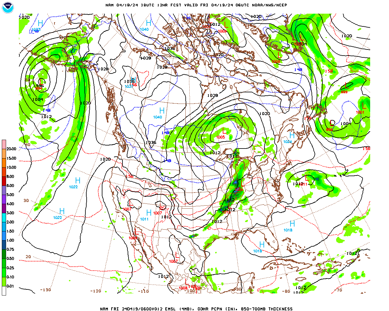
The Nam??? 
0 likes
Personal Forecast Disclaimer:
The posts in this forum are NOT official forecast and should not be used as such. They are just the opinion of the poster and may or may not be backed by sound meteorological data. They are NOT endorsed by any professional institution or storm2k.org. For official information, please refer to the NHC and NWS products.
The posts in this forum are NOT official forecast and should not be used as such. They are just the opinion of the poster and may or may not be backed by sound meteorological data. They are NOT endorsed by any professional institution or storm2k.org. For official information, please refer to the NHC and NWS products.
-
Weatherwatcher98
- Category 1
- Posts: 346
- Joined: Sat Sep 12, 2015 10:53 am
Re: ATL: JOAQUIN - Models
I knowstormlover2013 wrote:lol nam is worse then the CMC
0 likes
Personal Forecast Disclaimer:
The posts in this forum are NOT official forecast and should not be used as such. They are just the opinion of the poster and may or may not be backed by sound meteorological data. They are NOT endorsed by any professional institution or storm2k.org. For official information, please refer to the NHC and NWS products.
The posts in this forum are NOT official forecast and should not be used as such. They are just the opinion of the poster and may or may not be backed by sound meteorological data. They are NOT endorsed by any professional institution or storm2k.org. For official information, please refer to the NHC and NWS products.
-
Weatherwatcher98
- Category 1
- Posts: 346
- Joined: Sat Sep 12, 2015 10:53 am
Re: Re:
But your correct your going to have a lot of Rain but not from the Hurricane.Raebie wrote:windnrain wrote:
Nam 36h
Looks like I'm going to get wet. Very wet.
0 likes
Personal Forecast Disclaimer:
The posts in this forum are NOT official forecast and should not be used as such. They are just the opinion of the poster and may or may not be backed by sound meteorological data. They are NOT endorsed by any professional institution or storm2k.org. For official information, please refer to the NHC and NWS products.
The posts in this forum are NOT official forecast and should not be used as such. They are just the opinion of the poster and may or may not be backed by sound meteorological data. They are NOT endorsed by any professional institution or storm2k.org. For official information, please refer to the NHC and NWS products.
-
Rgv20

- S2K Supporter

- Posts: 2466
- Age: 39
- Joined: Wed Jan 05, 2011 5:42 pm
- Location: Edinburg/McAllen Tx
Thru 5 days most of the 12zECMWF Ensemble members have Joaquin well east of the US Coast. 1 ECMWF Ensemble Member has Joaquin moving to NE Florida, 1.9% chance of happening
0 likes
The following post is NOT an official forecast and should not be used as such. It is just the opinion of the poster and may or may not be backed by sound meteorological data. It is NOT endorsed by any professional institution including storm2k.org For Official Information please refer to the NHC and NWS products.

12z GFS looks worse for South Carolina than any of the prior runs rainfall wise. It is probably a combination of the front and possibly either some phased moisture from the outflow or generally enhanced precipitation. But the entire Central and Northern Coasts of SC are in the 15-20 inches plus yellow. That's within 4 days. That's more rain than almost any hurricane would lay down. I doubt we see anything quite that high, but you never know. If I was in a flood prone area or near a creek/river/stream that overflows its banks in bad weather, I'd be uneasy.
0 likes
Re: ATL: JOAQUIN - Models
Lest we forget, the NAM I believe was the only model other than the Euro to call for the northeast turn.
0 likes


Who is online
Users browsing this forum: No registered users and 39 guests