Seasonal Indicators (Beyond Day 16): Instability / SST's / MSLP / Steering / Sal
Moderator: S2k Moderators
Forum rules
The posts in this forum are NOT official forecasts and should not be used as such. They are just the opinion of the poster and may or may not be backed by sound meteorological data. They are NOT endorsed by any professional institution or STORM2K. For official information, please refer to products from the National Hurricane Center and National Weather Service.
Re: 2016 indicators: Instability / SST's / MSLP / Steering / Sal
I get the feeling we will see early development in the Caribbean this year if instability continues to stay up and Nino 1+2 along with Nino 3 continues to cool down. Windshear in the Caribbean is till a little above average but that should continue to come down during the next few weeks.


0 likes
-
TheStormExpert
Re: 2016 indicators: Instability / SST's / MSLP / Steering / Sal
Starting to agree with some that too many people are putting too much weight on the colder SST's located in the Northern Atlantic. The Atlantic very rarely has to worry about SST's not being warm enough to support tropical development throughout the hurricane season. If anything development may be delayed until the Caribbean or the Western Atlantic depending on if the waves survive the Tropical Atlantic depending on how hostile it may be this season.
0 likes
- Yellow Evan
- Professional-Met

- Posts: 16232
- Age: 27
- Joined: Fri Jul 15, 2011 12:48 pm
- Location: Henderson, Nevada/Honolulu, HI
- Contact:
Re: 2016 indicators: Instability / SST's / MSLP / Steering / Sal
TheStormExpert wrote:Starting to agree with some that too many people are putting too much weight on the colder SST's located in the Northern Atlantic. The Atlantic very rarely has to worry about SST's not being warm enough to support tropical development throughout the hurricane season. If anything development may be delayed until the Caribbean or the Western Atlantic depending on if the waves survive the Tropical Atlantic depending on how hostile it may be this season.
Colder SST's in the N ATL is a -AMO pattern that seldom favors elevated upward motion over the region though.
0 likes
Re: 2016 indicators: Instability / SST's / MSLP / Steering / Sal
Yeah the SST's set up is not so much important on energy for cyclones, always warm enough. The question is set up of pressures and air motion related to high and low pressures across the Atlantic such as strength of the Bermuda high. They can induce easterly shear (trades)
0 likes
The above post and any post by Ntxw is NOT an official forecast and should not be used as such. It is just the opinion of the poster and may or may not be backed by sound meteorological data. It is NOT endorsed by any professional institution including Storm2k. For official information, please refer to NWS products.
Re: 2016 indicators: Instability / SST's / MSLP / Steering / Sal
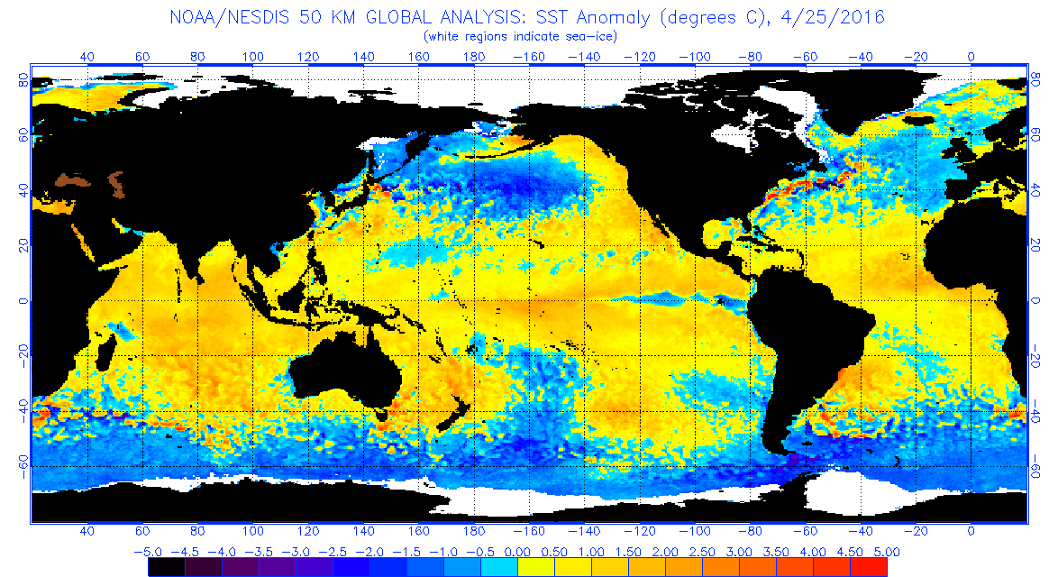
I still want to know why there is such a difference between these two across the central Atlantic's MDR but also look across the southern hemisphere close to the Antarctic, NESDIS shows much colder SSTs while CDAS shows areas with much warmer SSTs.
Looking at the buoys across the MDR east of the Islands they show warmer SSTs than this time last year by a good .5 degree celsius.


Looking at the buoys across the MDR east of the Islands they show warmer SSTs than this time last year by a good .5 degree celsius.


0 likes
-
TheStormExpert
Re: 2016 indicators: Instability / SST's / MSLP / Steering / Sal
0 likes
- WPBWeather
- S2K Supporter

- Posts: 535
- Age: 67
- Joined: Thu Jul 18, 2013 12:33 pm
Re: 2016 indicators: Instability / SST's / MSLP / Steering / Sal
Probably too much uncertainty with these maps at the moment. Bad data and models errors started this year off badly.
0 likes
-
TheStormExpert
Re: 2016 indicators: Instability / SST's / MSLP / Steering / Sal
WPBWeather wrote:Probably too much uncertainty with these maps at the moment. Bad data and models errors started this year off badly.
I agree, I also think this season will surprise us one way or another. Still a small chance though it is a dud like 2013.
0 likes
- Yellow Evan
- Professional-Met

- Posts: 16232
- Age: 27
- Joined: Fri Jul 15, 2011 12:48 pm
- Location: Henderson, Nevada/Honolulu, HI
- Contact:
Re: 2016 indicators: Instability / SST's / MSLP / Steering / Sal
TheStormExpert wrote::uarrow: The La Niña looks to be emerging quite nicely. Also if you look around Hawaii to the north and south in the Central Pacific you will see pockets of colder SST's. Wonder what(if any) effects this could have on the Atlantic hurricane season?
It's a classic +PDO signature, which I guess isn't that bad for the ATL.
0 likes
- SFLcane
- S2K Supporter

- Posts: 10281
- Age: 48
- Joined: Sat Jun 05, 2010 1:44 pm
- Location: Lake Worth Florida
Re: 2016 indicators: Instability / SST's / MSLP / Steering / Sal
Anything on sst map? Updated NOAA anomaly map still showing warm mdr which is way off from Levi site. Hopefully someone will come shed some light on this soon.
0 likes
- Kingarabian
- S2K Supporter

- Posts: 16355
- Joined: Sat Aug 08, 2009 3:06 am
- Location: Honolulu, Hawaii
Re: 2016 indicators: Instability / SST's / MSLP / Steering / Sal
Philip Klotzbach @philklotzbach 7h7 hours ago Lafayette, CA
Negative AMO pattern emerging in the N Atlantic-SSTs much colder now in far N and trop Atl compared w/ 1995-2012 avg
Negative AMO pattern emerging in the N Atlantic-SSTs much colder now in far N and trop Atl compared w/ 1995-2012 avg
0 likes
RIP Kobe Bryant
- WPBWeather
- S2K Supporter

- Posts: 535
- Age: 67
- Joined: Thu Jul 18, 2013 12:33 pm
Re: 2016 indicators: Instability / SST's / MSLP / Steering / Sal
Kingarabian wrote:Philip Klotzbach @philklotzbach 7h7 hours ago Lafayette, CA
Negative AMO pattern emerging in the N Atlantic-SSTs much colder now in far N and trop Atl compared w/ 1995-2012 avg
But in a rejoinder to the (obvious) hurricane numbers questions...
Philip Klotzbach
@philklotzbach
... No correlation between SSTs and hurricane numbers N of 20N and W of 60W.
6:21 PM - 26 Apr 2016
0 likes
- Hurricaneman
- Category 5

- Posts: 7404
- Age: 45
- Joined: Tue Aug 31, 2004 3:24 pm
- Location: central florida
Re: 2016 indicators: Instability / SST's / MSLP / Steering / Sal
Looking at the atlantic it looks quite hostile and that may be something to watch especially if the shear stays high as that may have something to do with the warmth in the EPAC MDR
The posts in this forum are NOT official forecast and should not be used as such. They are just the opinion of the poster and may or may not be backed by sound meteorological data. They are NOT endorsed by any professional institution or storm2k.org. For official information, please refer to the NHC and NWS products
The posts in this forum are NOT official forecast and should not be used as such. They are just the opinion of the poster and may or may not be backed by sound meteorological data. They are NOT endorsed by any professional institution or storm2k.org. For official information, please refer to the NHC and NWS products
0 likes
Re: 2016 indicators: Instability / SST's / MSLP / Steering / Sal
Hurricaneman wrote:Looking at the atlantic it looks quite hostile and that may be something to watch especially if the shear stays high as that may have something to do with the warmth in the EPAC MDR
The posts in this forum are NOT official forecast and should not be used as such. They are just the opinion of the poster and may or may not be backed by sound meteorological data. They are NOT endorsed by any professional institution or storm2k.org. For official information, please refer to the NHC and NWS products
Is only April and we are coming out of a very strong El Nino so of course shear is very high across the Atlantic basin.
CFSv2 is still very persistent in shear becoming below average across the Caribbean next month.
0 likes
- SFLcane
- S2K Supporter

- Posts: 10281
- Age: 48
- Joined: Sat Jun 05, 2010 1:44 pm
- Location: Lake Worth Florida
Re: 2016 indicators: Instability / SST's / MSLP / Steering / Sal
Um...holy mother of sst's lol. Either that was some serious warming or was NOAA's sst map correct all the time?


0 likes
- hurricanetrack
- HurricaneTrack.com

- Posts: 1781
- Joined: Tue Dec 02, 2003 10:46 pm
- Location: Wilmington, NC
- Contact:
Re: 2016 indicators: Instability / SST's / MSLP / Steering / Sal
http://www.ospo.noaa.gov/data/sst/anoma ... 8.2016.gif
Here is the latest NOAA/NESDIS one. Very warm MDR - no two ways about it. Things looking interesting I would say....
Here is the latest NOAA/NESDIS one. Very warm MDR - no two ways about it. Things looking interesting I would say....
0 likes
- SFLcane
- S2K Supporter

- Posts: 10281
- Age: 48
- Joined: Sat Jun 05, 2010 1:44 pm
- Location: Lake Worth Florida
Re: 2016 indicators: Instability / SST's / MSLP / Steering / Sal
hurricanetrack wrote:http://www.ospo.noaa.gov/data/sst/anomaly/2016/anomw.4.28.2016.gif
Here is the latest NOAA/NESDIS one. Very warm MDR - no two ways about it. Things looking interesting I would say....
Impressive..
0 likes
- SFLcane
- S2K Supporter

- Posts: 10281
- Age: 48
- Joined: Sat Jun 05, 2010 1:44 pm
- Location: Lake Worth Florida
Re: 2016 indicators: Instability / SST's / MSLP / Steering / Sal
curious to see what ECMWF has to say in a few days
0 likes
- Kingarabian
- S2K Supporter

- Posts: 16355
- Joined: Sat Aug 08, 2009 3:06 am
- Location: Honolulu, Hawaii
Re: 2016 indicators: Instability / SST's / MSLP / Steering / Sal
Almost 100kts of shear in the Caribbean.
0 likes
RIP Kobe Bryant
Who is online
Users browsing this forum: No registered users and 173 guests


