2016 Global Model Runs Discussion (Out to Day 16)

This is the general tropical discussion area. Anyone can take their shot at predicting a storms path.

Moderator: S2k Moderators

Forum rules

The posts in this forum are NOT official forecasts and should not be used as such. They are just the opinion of the poster and may or may not be backed by sound meteorological data. They are NOT endorsed by any professional institution or STORM2K. For official information, please refer to products from the National Hurricane Center and National Weather Service.

Help Support Storm2K
Message
Author
User avatar
TheAustinMan
Category 5
Category 5
Posts: 1047
Age: 25
Joined: Mon Jul 08, 2013 4:26 pm
Location: United States
Contact:

Re: 2016 Global Model Runs Discussion

#141 Postby TheAustinMan » Sun May 22, 2016 5:53 pm

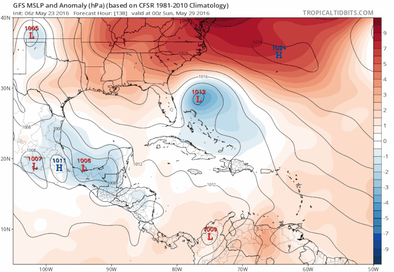
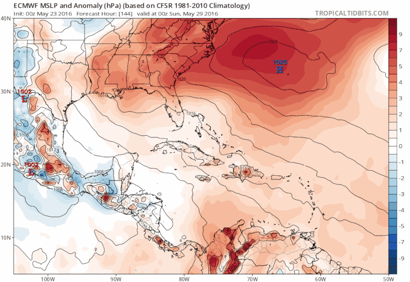
TheStormExpert wrote::uarrow: Well the GFS and Euro seem to be pushing the timeframe back so it is likely yet another phantom storm.


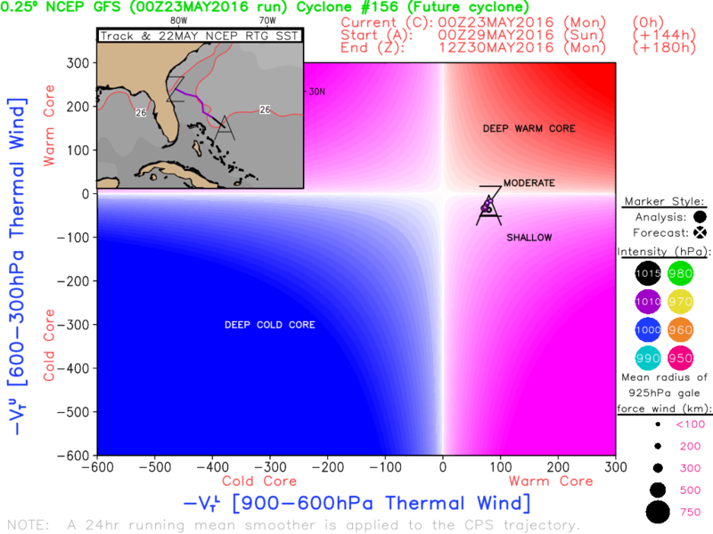
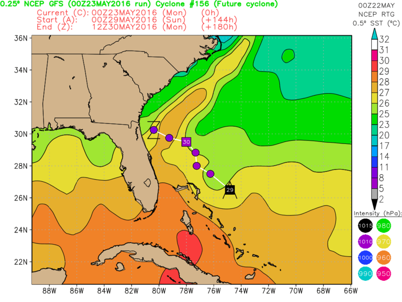
Are you sure the timeframe is being pushed back? The Euro does seem to have been keeping the disturbance at 240 hours, but the GFS so far has only shifted the disturbance's future track eastward, and the extra time tagged on appears to reflect a more easterly track as opposed to running up Florida's spine (which would mean a stormy Memorial Day weekend for Florida). The GFS develops a broad circulation at the 700mb-400mb levels over the Bahamas beginning Thursday, May 26, and that timing has been particularly persistent for the past several runs.

The posts in this forum are NOT official forecast and should not be used as such. They are just the opinion of the poster and may or may not be backed by sound meteorological data. They are NOT endorsed by any professional institution or storm2k.org. For official information, please refer to the NHC and NWS products.
0 likes   
ImageImageImage
Treat my opinions with a grain of salt. For official information see your local weather service.

floridasun78
Category 5
Category 5
Posts: 3755
Joined: Sun May 17, 2009 10:16 pm
Location: miami fl

Re: 2016 Global Model Runs Discussion

#142 Postby floridasun78 » Sun May 22, 2016 10:22 pm

my weather man here in Miami talking that low may form in Bahama and be close enough bring some rain for long weekend but he say will move toward Carolina
0 likes   

User avatar
WPBWeather
S2K Supporter
S2K Supporter
Posts: 535
Age: 67
Joined: Thu Jul 18, 2013 12:33 pm

Re: 2016 Global Model Runs Discussion

#143 Postby WPBWeather » Sun May 22, 2016 10:27 pm

floridasun78 wrote:my weather man here in Miami talking that low may form in Bahama and be close enough bring some rain for long weekend but he say will move toward Carolina


Welcome back.
0 likes   

floridasun78
Category 5
Category 5
Posts: 3755
Joined: Sun May 17, 2009 10:16 pm
Location: miami fl

Re: 2016 Global Model Runs Discussion

#144 Postby floridasun78 » Sun May 22, 2016 10:29 pm

i notice nws in miami are not biting on area forming by Bahamas yet here what their say Wednesday and Beyond: While the main upper level trough moves away
from the east coast by mid week, models have been consistent in
showing the southern portion cutting off over the Bahamas into
late week. At the surface, high pressure strengthens over the
Western Atlantic, leading to increasing easterly flow for the
latter half of the week.
0 likes   

floridasun78
Category 5
Category 5
Posts: 3755
Joined: Sun May 17, 2009 10:16 pm
Location: miami fl

Re: 2016 Global Model Runs Discussion

#145 Postby floridasun78 » Sun May 22, 2016 10:32 pm

WPBWeather wrote:
floridasun78 wrote:my weather man here in Miami talking that low may form in Bahama and be close enough bring some rain for long weekend but he say will move toward Carolina


Welcome back.

ty you see me here doing hurr season one channel here ch10 already doing hurr special on Friday 8pm
0 likes   

User avatar
NDG
S2K Supporter
S2K Supporter
Posts: 15446
Joined: Sun Jul 09, 2006 10:14 pm
Location: Orlando, FL

Re: 2016 Global Model Runs Discussion

#146 Postby NDG » Mon May 23, 2016 6:07 am

The GFS has become very persistent and consistent in the formation of a low pressure just east of FL by late Sat/Sunday timeframe, I have counted at least 4 runs in row.
The Euro is also joining the GFS, but shows timing of development a good 48 hrs later than the GFS.

Image
Image
0 likes   

TheStormExpert

Re: 2016 Global Model Runs Discussion

#147 Postby TheStormExpert » Mon May 23, 2016 6:40 am

:uarrow: It look is like weak Subtropical development if anything.
0 likes   

User avatar
NDG
S2K Supporter
S2K Supporter
Posts: 15446
Joined: Sun Jul 09, 2006 10:14 pm
Location: Orlando, FL

Re: 2016 Global Model Runs Discussion

#148 Postby NDG » Mon May 23, 2016 7:13 am

TheStormExpert wrote::uarrow: It look is like weak Subtropical development if anything.


Yes, UL trough is what's going to get it going, according to the GFS, so it will not be a pure tropical system in its beginning but it could gain more tropical characteristics as it moves over the warmer gulf stream.

Image
Image
0 likes   

TheStormExpert

Re: 2016 Global Model Runs Discussion

#149 Postby TheStormExpert » Mon May 23, 2016 7:18 am

I was just thinking that, the GFS looks to try and start ramping it up as it approaches the coast due to crossing the Gulf Stream. Got to watch that as we've seen storms transition to purely tropical very easily once done so, good example is Beryl(2012).
0 likes   

User avatar
cycloneye
Admin
Admin
Posts: 145295
Age: 68
Joined: Thu Oct 10, 2002 10:54 am
Location: San Juan, Puerto Rico

Re: 2016 Global Model Runs Discussion

#150 Postby cycloneye » Mon May 23, 2016 9:33 am

Levi says things are not clear about mischief off SE U.S coast.

Levi Cowan ‏@TropicalTidbits · 45m45 minutes ago

GFS and ECMWF disagree strongly on evolution of W. Atlantic cutoff low. Both models have biases in this situation.

0 likes   
Visit the Caribbean-Central America Weather Thread where you can find at first post web cams,radars
and observations from Caribbean basin members Click Here

User avatar
South Texas Storms
Professional-Met
Professional-Met
Posts: 4224
Joined: Thu Jun 24, 2010 12:28 am
Location: Houston, TX

Re: 2016 Global Model Runs Discussion

#151 Postby South Texas Storms » Mon May 23, 2016 11:13 am

The 12z GFS has sped up the time of the possible SE U.S. system from the past few runs. Now has it just offshore the GA/SC coast in 120 hours.
0 likes   

TheStormExpert

Re: 2016 Global Model Runs Discussion

#152 Postby TheStormExpert » Mon May 23, 2016 11:37 am

South Texas Storms wrote:The 12z GFS has sped up the time of the possible SE U.S. system from the past few runs. Now has it just offshore the GA/SC coast in 120 hours.

12z run is weaker than previous two runs.
0 likes   

User avatar
gatorcane
S2K Supporter
S2K Supporter
Posts: 23691
Age: 47
Joined: Sun Mar 13, 2005 3:54 pm
Location: Boca Raton, FL

Re: 2016 Global Model Runs Discussion

#153 Postby gatorcane » Mon May 23, 2016 11:39 am

floridasun78 wrote:i notice nws in miami are not biting on area forming by Bahamas yet here what their say Wednesday and Beyond: While the main upper level trough moves away
from the east coast by mid week, models have been consistent in
showing the southern portion cutting off over the Bahamas into
late week. At the surface, high pressure strengthens over the
Western Atlantic, leading to increasing easterly flow for the
latter half of the week.


if Florida ends up on the subsidence side of this low (west side) as it tracks NW east of the Bahamas (as shown by the latest GFS run), it would just mean drier and hotter weather for Florida. Models seem all over the place with the evolution of this low so we'll have to wait and see what impacts to Florida for Memorial Day weekend there will be, if any.
0 likes   

WeatherEmperor
S2K Supporter
S2K Supporter
Posts: 4806
Age: 41
Joined: Thu Sep 04, 2003 2:54 pm
Location: South Florida

Re: 2016 Global Model Runs Discussion

#154 Postby WeatherEmperor » Mon May 23, 2016 12:15 pm

I apologize if I am going off topic...but is this the newly upgraded Gfs or not?

South Texas Storms wrote:The 12z GFS has sped up the time of the possible SE U.S. system from the past few runs. Now has it just offshore the GA/SC coast in 120 hours.
0 likes   

User avatar
crownweather
S2K Supporter
S2K Supporter
Posts: 595
Age: 50
Joined: Sat Aug 12, 2006 9:21 am
Location: Sturbridge, Massachusetts
Contact:

Re: 2016 Global Model Runs Discussion

#155 Postby crownweather » Mon May 23, 2016 12:18 pm

WeatherEmperor wrote:I apologize if I am going off topic...but is this the newly upgraded Gfs or not?

South Texas Storms wrote:The 12z GFS has sped up the time of the possible SE U.S. system from the past few runs. Now has it just offshore the GA/SC coast in 120 hours.


Yes, it is the upgraded GFS model.
0 likes   
Rob Lightbown
Crown Weather Services
https://crownweather.com

User avatar
cycloneye
Admin
Admin
Posts: 145295
Age: 68
Joined: Thu Oct 10, 2002 10:54 am
Location: San Juan, Puerto Rico

Re: 2016 Global Model Runs Discussion

#156 Postby cycloneye » Mon May 23, 2016 12:21 pm

Accuweather jumps on board for development.

http://www.accuweather.com/en/weather-n ... d/57639474

Image
0 likes   
Visit the Caribbean-Central America Weather Thread where you can find at first post web cams,radars
and observations from Caribbean basin members Click Here

User avatar
tarheelprogrammer
S2K Supporter
S2K Supporter
Posts: 1793
Joined: Mon Mar 28, 2016 9:25 pm
Location: Raleigh, NC area (Garner, NC)

Re: 2016 Global Model Runs Discussion

#157 Postby tarheelprogrammer » Mon May 23, 2016 12:25 pm

cycloneye wrote:Accuweather jumps on board for development.

http://www.accuweather.com/en/weather-n ... d/57639474

Image


How warm is the water?
0 likes   
My posts are not official forecasts. They are just my opinion and may or may not be backed by sound meteorological data. They are NOT endorsed by any professional institution or storm2k.org. For official information, please refer to the NHC and NWS products.

User avatar
cycloneye
Admin
Admin
Posts: 145295
Age: 68
Joined: Thu Oct 10, 2002 10:54 am
Location: San Juan, Puerto Rico

Re: 2016 Global Model Runs Discussion

#158 Postby cycloneye » Mon May 23, 2016 12:35 pm

Waters ae not extremely warm but are sufficient to support development of a Tropical system especially in the Gulfstream.If is subtropical,it can survive some cooler waters.

Image
0 likes   
Visit the Caribbean-Central America Weather Thread where you can find at first post web cams,radars
and observations from Caribbean basin members Click Here

User avatar
cycloneye
Admin
Admin
Posts: 145295
Age: 68
Joined: Thu Oct 10, 2002 10:54 am
Location: San Juan, Puerto Rico

Re: 2016 Global Model Runs Discussion

#159 Postby cycloneye » Mon May 23, 2016 12:40 pm

No new thread for this potential area will not be posted at this time so let's keep the discussions about this area in this thread for now. From our announcement thread about this:

...in the medium/extended range is not allowed, unless:

1) There is an actual incipient area of disturbed weather already in place, or
2) It is being mentioned in the NHC Tropical Weather Outlook
0 likes   
Visit the Caribbean-Central America Weather Thread where you can find at first post web cams,radars
and observations from Caribbean basin members Click Here

User avatar
tarheelprogrammer
S2K Supporter
S2K Supporter
Posts: 1793
Joined: Mon Mar 28, 2016 9:25 pm
Location: Raleigh, NC area (Garner, NC)

Re: 2016 Global Model Runs Discussion

#160 Postby tarheelprogrammer » Mon May 23, 2016 12:41 pm

Thanks Cycloneye
0 likes   
My posts are not official forecasts. They are just my opinion and may or may not be backed by sound meteorological data. They are NOT endorsed by any professional institution or storm2k.org. For official information, please refer to the NHC and NWS products.


Return to “Talkin' Tropics”

Who is online

Users browsing this forum: gib, Hurricane2022, HurricaneFan, RomP and 49 guests