ATL: BONNIE - Post-Tropical - Discussion

Moderator: S2k Moderators

Message
Author
tolakram
Admin
Admin
Posts: 20009
Age: 62
Joined: Sun Aug 27, 2006 8:23 pm
Location: Florence, KY (name is Mark)

Re: ATL: BONNIE - Tropical Storm - Discussion

#461 Postby tolakram » Sun May 29, 2016 5:45 am

0 likes   
M a r k
- - - - -
Join us in chat: Storm2K Chatroom Invite. Android and IOS apps also available.

The posts in this forum are NOT official forecasts and should not be used as such. Posts are NOT endorsed by any professional institution or STORM2K.org. For official information and forecasts, please refer to NHC and NWS products.

tolakram
Admin
Admin
Posts: 20009
Age: 62
Joined: Sun Aug 27, 2006 8:23 pm
Location: Florence, KY (name is Mark)

Re: ATL: BONNIE - Tropical Storm - Discussion

#462 Postby tolakram » Sun May 29, 2016 6:21 am

0 likes   
M a r k
- - - - -
Join us in chat: Storm2K Chatroom Invite. Android and IOS apps also available.

The posts in this forum are NOT official forecasts and should not be used as such. Posts are NOT endorsed by any professional institution or STORM2K.org. For official information and forecasts, please refer to NHC and NWS products.

tolakram
Admin
Admin
Posts: 20009
Age: 62
Joined: Sun Aug 27, 2006 8:23 pm
Location: Florence, KY (name is Mark)

Re: ATL: BONNIE - Tropical Storm - Discussion

#463 Postby tolakram » Sun May 29, 2016 6:28 am

saved radar loop
Image
0 likes   
M a r k
- - - - -
Join us in chat: Storm2K Chatroom Invite. Android and IOS apps also available.

The posts in this forum are NOT official forecasts and should not be used as such. Posts are NOT endorsed by any professional institution or STORM2K.org. For official information and forecasts, please refer to NHC and NWS products.

NotoSans
Category 5
Category 5
Posts: 1380
Age: 25
Joined: Sun Sep 27, 2015 1:15 am
Location: Toronto
Contact:

Re: ATL: BONNIE - Recon

#464 Postby NotoSans » Sun May 29, 2016 6:45 am

000
URNT12 KNHC 291118
VORTEX DATA MESSAGE AL022016
A. 29/11:00:30Z
B. 32 deg 35 min N
079 deg 39 min W
C. 925 mb 772 m
D. 36 kt
E. 249 deg 18 nm
F. 179 deg 25 kt
G. 080 deg 10 nm
H. EXTRAP 1011 mb
I. 18 C / 758 m
J. 20 C / 761 m
K. NA / NA
L. NA
M. NA
N. 1234 / 9
O. 0.02 / 4 nm
P. AF300 0402A BONNIE OB 05
MAX OUTBOUND AND MAX FL WIND 31 KT 136 / 21 NM 11:08:00Z
SLP EXTRAP FROM 925 MB
;
0 likes   
Personal Forecast Disclaimer:
The posts in this forum are NOT official forecast and should not be used as such. They are just the opinion of the poster and may or may not be backed by sound meteorological data. They are NOT endorsed by any professional institution or storm2k.org. For official information, please refer to RSMC and NWS products.

User avatar
HurricaneBelle
S2K Supporter
S2K Supporter
Posts: 1179
Joined: Sun Aug 27, 2006 6:12 pm
Location: Clearwater, FL

Re: ATL: BONNIE - Tropical Storm - Discussion

#465 Postby HurricaneBelle » Sun May 29, 2016 6:59 am

Now officially a depression:

WTNT32 KNHC 291154
TCPAT2

BULLETIN
TROPICAL DEPRESSION BONNIE INTERMEDIATE ADVISORY NUMBER 7A
NWS NATIONAL HURRICANE CENTER MIAMI FL AL022016
800 AM EDT SUN MAY 29 2016

...BONNIE WEAKENS TO A TROPICAL DEPRESSION NEAR THE COAST...
...HEAVY RAINS STILL AFFECTING MUCH OF EASTERN GEORGIA
AND PORTIONS OF THE CAROLINAS...
0 likes   

User avatar
wxman57
Moderator-Pro Met
Moderator-Pro Met
Posts: 22978
Age: 67
Joined: Sat Jun 21, 2003 8:06 pm
Location: Houston, TX (southwest)

Re: ATL: BONNIE - Tropical Depression - Discussion

#466 Postby wxman57 » Sun May 29, 2016 7:28 am

Looks like Charleston is getting pummeled by 15kt winds and showers. There's not much left of Bonnie this morning. Perhaps part of the weekend can be salvaged in the Carolinas. Most of Bonnie's rain is on the NC coast and in Georgia.
0 likes   

User avatar
drezee
S2K Supporter
S2K Supporter
Posts: 3664
Joined: Mon Jun 09, 2003 12:49 pm
Location: FL

Re: ATL: BONNIE - Tropical Depression - Discussion

#467 Postby drezee » Sun May 29, 2016 9:44 am

wxman57 wrote:Looks like Charleston is getting pummeled by 15kt winds and showers. There's not much left of Bonnie this morning. Perhaps part of the weekend can be salvaged in the Carolinas. Most of Bonnie's rain is on the NC coast and in Georgia.

Agreed, not much there but local heavy rain. Strongest winds on the South side of the center. Base at Charleston reported over two inches of rain in less than 2 hrs and gusts to 40 mph...

http://w1.weather.gov/data/obhistory/KCHS.html
0 likes   

SeGaBob

Re: ATL: BONNIE - Tropical Depression - Discussion

#468 Postby SeGaBob » Sun May 29, 2016 9:48 am

I've got a 1 1/2 so far

THE NATIONAL WEATHER SERVICE IN CHARLESTON HAS ISSUED A

* FLASH FLOOD WARNING FOR PORTIONS OF...
BULLOCH COUNTY IN SOUTHEASTERN GEORGIA...
EFFINGHAM COUNTY IN SOUTHEASTERN GEORGIA...
BRYAN COUNTY IN SOUTHEASTERN GEORGIA...

* UNTIL 1245 PM EDT

* AT 950 AM EDT...DOPPLER RADAR INDICATED THUNDERSTORMS PRODUCING
HEAVY RAIN ACROSS THE WARNED AREA. FLASH FLOODING IS EXPECTED TO
BEGIN SHORTLY.

* SOME LOCATIONS THAT WILL EXPERIENCE FLOODING INCLUDE...
STATESBORO...BAY...LANIER...BROOKLET...STILSON...MELDRIM...LEEFIELD AND
MARLOW.

RAINFALL AMOUNTS OF 2 TO 4 INCHES OF RAIN HAVE BEEN REPORTED OVER
THE LAST 24 HOURS...WITH THE HEAVIEST AMOUNTS FALLING FROM AROUND
EDEN...NORTHEAST THROUGH STILSON AND BROOKLET...AS WELL AS
STATESBORO. A NEARLY STATIONARY BAND OF MODERATE TO HEAVY RAIN HAS
SET UP ACROSS THE WARNED AREA AND WILL LIKELY PRODUCE AN ADDITIONAL
1 TO 3 INCHES OF RAIN OVER THE NEXT 2 TO 3 HOURS.
FURTHERMORE...BULLOCH COUNTY DISPATCH RECENTLY REPORTED WATER ON
AREA ROADWAYS AND THE DOT IS BEGINNING TO CLOSE OFF ROADS WHERE THE
WATER IS GETTING DEEPEST.
0 likes   

User avatar
cycloneye
Admin
Admin
Posts: 145295
Age: 68
Joined: Thu Oct 10, 2002 10:54 am
Location: San Juan, Puerto Rico

Re: ATL: BONNIE - Advisories

#469 Postby cycloneye » Sun May 29, 2016 9:53 am

TROPICAL DEPRESSION BONNIE DISCUSSION NUMBER 8
NWS NATIONAL HURRICANE CENTER MIAMI FL AL022016
1100 AM EDT SUN MAY 29 2016

Most of the deep convection associated with the tropical cyclone
became separated from the center overnight, and Bonnie weakened to a
tropical depression before reaching the south-central coast of South
Carolina. Aircraft data indicate that Bonnie made landfall just east
of Charleston near the Isle of Palms around 1230 UTC.

The tropical cyclone has continued to move faster than expected,
with an initial motion estimate of 360/8 kt. The global models
insist that a reduction in forward speed will occur today while the
cyclone moves around the northwestern portion of a low- to mid-level
ridge over the western Atlantic. As a result of the faster forward
motion, the NHC forecast track has been adjusted northward
accordingly, and now shows the center moving farther inland during
the next day or so. After 48 hours, a slightly faster northeastward
motion is expected to begin. The updated NHC track is close to the
GFS/ECMWF consensus.

Bonnie is forecast to weaken some during the next 12 to 24 hours,
but little change in strength is expected after that time since a
portion of the circulation could be over water. A track farther
inland than anticipated would result in a faster rate of weakening,
and Bonnie would become a remnant low sooner in this scenario.

The primary impact from Bonnie will continue to be locally heavy
rainfall, which is occurring over much of eastern Georgia, and
portions of the Carolinas. These rains will gradually spread
northeastward over the Mid-Atlantic region during the next couple
of days.

FORECAST POSITIONS AND MAX WINDS

INIT 29/1500Z 33.2N 79.8W 30 KT 35 MPH
12H 30/0000Z 33.6N 79.8W 25 KT 30 MPH
24H 30/1200Z 34.0N 79.5W 25 KT 30 MPH...INLAND
36H 31/0000Z 34.1N 79.0W 25 KT 30 MPH...INLAND
48H 31/1200Z 34.1N 78.3W 25 KT 30 MPH...INLAND
72H 01/1200Z 35.3N 76.4W 25 KT 30 MPH...POST-TROP/REMNT LOW
96H 02/1200Z 36.5N 74.5W 25 KT 30 MPH...POST-TROP/REMNT LOW
120H 03/1200Z 38.5N 72.0W 25 KT 30 MPH...POST-TROP/REMNT LOW

$$
Forecaster Brown
0 likes   
Visit the Caribbean-Central America Weather Thread where you can find at first post web cams,radars
and observations from Caribbean basin members Click Here

psyclone
S2K Supporter
S2K Supporter
Posts: 4762
Joined: Wed Aug 24, 2005 9:04 pm
Location: palm harbor fl

Re: ATL: BONNIE - Tropical Depression - Discussion

#470 Postby psyclone » Sun May 29, 2016 10:06 am

:uarrow: You guys are doing well. I'm surprised at how much good rain made onto the GA side of the Savannah river. Enjoy your water. I wish we could get some here.
0 likes   

psyclone
S2K Supporter
S2K Supporter
Posts: 4762
Joined: Wed Aug 24, 2005 9:04 pm
Location: palm harbor fl

Re: ATL: BONNIE - Tropical Depression - Discussion

#471 Postby psyclone » Sun May 29, 2016 10:09 am

wxman57 wrote:Looks like Charleston is getting pummeled by 15kt winds and showers. There's not much left of Bonnie this morning. Perhaps part of the weekend can be salvaged in the Carolinas. Most of Bonnie's rain is on the NC coast and in Georgia.

Haha. I think most of us thought this would be 2 shades of lame. It is just the doorbell ringing for the season. things are going to get spicier with time.
0 likes   

User avatar
cycloneye
Admin
Admin
Posts: 145295
Age: 68
Joined: Thu Oct 10, 2002 10:54 am
Location: San Juan, Puerto Rico

Re: ATL: BONNIE - Tropical Depression - Discussion

#472 Postby cycloneye » Sun May 29, 2016 10:30 am

Great view of the sunrise from plane that went to ex Bonnie early this morning.

Image
0 likes   
Visit the Caribbean-Central America Weather Thread where you can find at first post web cams,radars
and observations from Caribbean basin members Click Here

User avatar
cycloneye
Admin
Admin
Posts: 145295
Age: 68
Joined: Thu Oct 10, 2002 10:54 am
Location: San Juan, Puerto Rico

Re: ATL: BONNIE - Advisories

#473 Postby cycloneye » Sun May 29, 2016 3:34 pm

BULLETIN
TROPICAL DEPRESSION BONNIE ADVISORY NUMBER 9
NWS NATIONAL HURRICANE CENTER MIAMI FL AL022016
500 PM EDT SUN MAY 29 2016

...BONNIE STALLS NORTHWEST OF CHARLESTON SOUTH CAROLINA...
...LOCALLY HEAVY RAINS STILL AFFECTING PORTIONS OF THE CAROLINAS
AND EAST-CENTRAL GEORGIA...


SUMMARY OF 500 PM EDT...2100 UTC...INFORMATION
----------------------------------------------
LOCATION...33.0N 80.4W
ABOUT 25 MI...45 KM WNW OF CHARLESTON SOUTH CAROLINA
ABOUT 100 MI...160 KM WSW OF MYRTLE BEACH SOUTH CAROLINA
MAXIMUM SUSTAINED WINDS...30 MPH...45 KM/H
PRESENT MOVEMENT...STATIONARY
MINIMUM CENTRAL PRESSURE...1011 MB...29.86 INCHES


WATCHES AND WARNINGS
--------------------
There are no coastal watches or warnings in effect.

For information specific to your area, including possible inland
watches and warnings, please monitor products issued by your
local National Weather Service forecast office.


DISCUSSION AND 48-HOUR OUTLOOK
------------------------------
At 500 PM EDT (2100 UTC), the center of Tropical Depression Bonnie
was located near latitude 33.0 North, longitude 80.4 West. The
depression has become nearly stationary, but a slow northeastward
motion is forecast to begin tonight and continue through Monday
night. On the forecast track, the center of Bonnie is expected to
move over northeastern South Carolina through Monday, and pass near
or over the southeastern coast of North Carolina Monday night and
Tuesday.

Maximum sustained winds have decreased to near 30 mph (45 km/h) with
higher gusts. Little change in strength is expected during the next
48 hours.

The estimated minimum central pressure is 1011 mb (29.86 inches).


HAZARDS AFFECTING LAND
----------------------
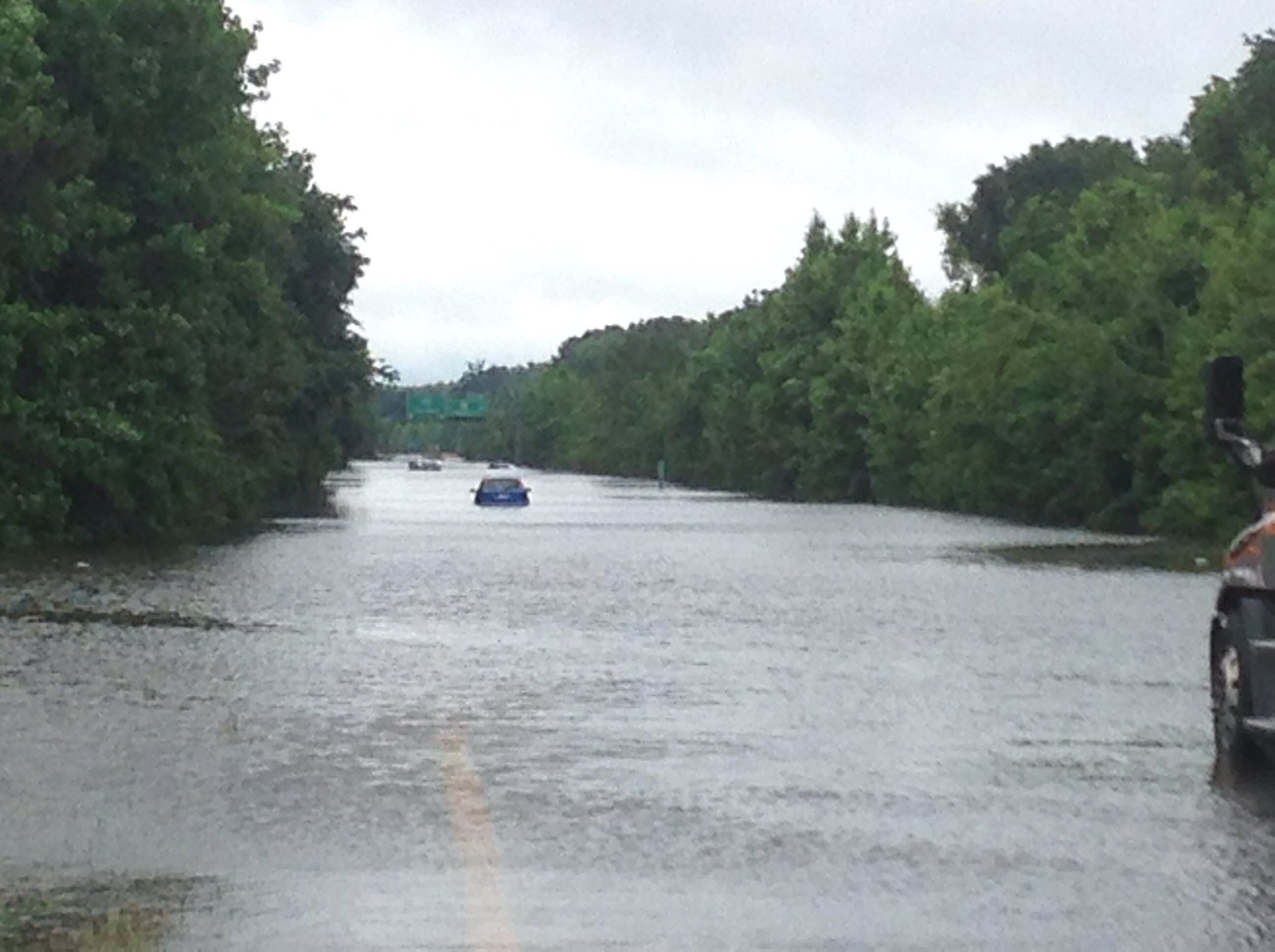
RAINFALL: Bonnie is expected to produce additional rainfall
accumulations of 2 to 3 inches with isolated maximum amounts of 6
inches across east-central Georgia, central and eastern South
Carolina, and eastern North Carolina. Farther north, the moisture
from Bonnie will produce rainfall amounts of 1 to 2 inches with
isolated maximum amounts of 4 inches across eastern portions of the
mid-Atlantic region into southern New England through Wednesday.

Some rainfall totals so far include 8.20 inches near Ridgeland,
South Carolina, and 7.27 inches near Oliver, Georgia.

SURF: Bonnie is expected to produce dangerous surf and rip current
conditions along portions of the southeastern United States coast
through the weekend. Please consult products from your local
weather office.


NEXT ADVISORY
-------------
Next complete advisory at 1100 PM EDT.

$$
Forecaster Brown


TROPICAL DEPRESSION BONNIE DISCUSSION NUMBER 9
NWS NATIONAL HURRICANE CENTER MIAMI FL AL022016
500 PM EDT SUN MAY 29 2016

The much anticipated reduction in Bonnie's forward motion appears to
have occurred this afternoon. Since the previous advisory, the
tropical cyclone jogged westward and has become nearly stationary
just northwest of Charleston, South Carolina. The highest wind
observations this afternoon have been 25-30 kt at the Fort Pulaski
C-Man site near the Georgia/South Carolina border around 1700 UTC.
Since the time, the highest wind reports have been 20-25 kt over
water, and the initial wind speed has been reduced to 25 kt for this
advisory.

Bonnie is expected to meander near the south-central coast of South
Carolina overnight, before beginning a northeastward motion on
Monday around the northwestern portion of a low- to mid-level ridge
over the western Atlantic. In 2 to 3 days, a slightly faster
northeastward or east-northeastward motion is forecast as the low-
to mid-level westerly flow off the Mid-Atlantic coast strengthens.
The global models are in generally good agreement of this scenario,
but there are some forward speed differences, especially beyond 72
hours. The NHC track is similar to the previous advisory and is
once again close to the GFS/ECMWF consensus.

Since a portion of the circulation is expected to remain over water
during the next few days, little change in strength is expected.
After exiting the coast of North Carolina in about 72 hours, the
cyclone will be moving over cool waters, which should cause Bonnie
to become post-tropical.

Locally heavy rains continue to be the primary concern from Bonnie.
Isolated rainfall amounts of 6 to 8 inches have already been
reported in portions of eastern Georgia and southern South Carolina.
Additional rainfall amounts of 1 to 3 inches are possible.

FORECAST POSITIONS AND MAX WINDS

INIT 29/2100Z 33.0N 80.4W 25 KT 30 MPH...INLAND
12H 30/0600Z 33.2N 80.1W 25 KT 30 MPH...INLAND
24H 30/1800Z 33.7N 79.4W 25 KT 30 MPH...INLAND
36H 31/0600Z 34.0N 78.8W 25 KT 30 MPH...INLAND
48H 31/1800Z 34.4N 78.0W 25 KT 30 MPH...INLAND
72H 01/1800Z 35.4N 76.4W 25 KT 30 MPH...POST-TROP/REMNT LOW
96H 02/1800Z 37.0N 74.5W 25 KT 30 MPH...POST-TROP/REMNT LOW
120H 03/1800Z 38.5N 71.5W 25 KT 30 MPH...POST-TROP/REMNT LOW

$$
Forecaster Brown
0 likes   
Visit the Caribbean-Central America Weather Thread where you can find at first post web cams,radars
and observations from Caribbean basin members Click Here

User avatar
AJC3
Admin
Admin
Posts: 3999
Age: 61
Joined: Tue Aug 31, 2004 7:04 pm
Location: Ballston Spa, New York
Contact:

Re: ATL: BONNIE - Tropical Depression - Discussion

#474 Postby AJC3 » Sun May 29, 2016 8:29 pm

Tweet about the flooding along I-95 in parts of SC...

https://twitter.com/ZachDanielCBS6/stat ... 3481618432

Zach Daniel ‏@ZachDanielCBS6 2h2 hours ago
UNBELIEVABLE flooding on I-95 between Hilton Head and Savannah! Traffic is backed up over 35 miles! #Bonnie @CBS6

Image
0 likes   

tatertawt24
Category 1
Category 1
Posts: 309
Joined: Wed Oct 24, 2012 12:57 pm

Re: ATL: BONNIE - Tropical Depression - Discussion

#475 Postby tatertawt24 » Sun May 29, 2016 8:38 pm

Why are people driving through that... :wall:
0 likes   
Personal Forecast Disclaimer:
The posts in this forum are NOT official forecast and should not be used as such. They are just the opinion of the poster and may or may not be backed by sound meteorological data. They are NOT endorsed by any professional institution or storm2k.org. For official information, please refer to the NHC and NWS products.

User avatar
wxman57
Moderator-Pro Met
Moderator-Pro Met
Posts: 22978
Age: 67
Joined: Sat Jun 21, 2003 8:06 pm
Location: Houston, TX (southwest)

Re: ATL: BONNIE - Tropical Depression - Discussion

#476 Postby wxman57 » Sun May 29, 2016 8:41 pm

Bonnie looks like a remnant low now. Winds across the Carolinas are 10kts or less, with only scattered showers. NHC will likely issue a final advisory at 10.
0 likes   

SeGaBob

Re: ATL: BONNIE - Tropical Depression - Discussion

#477 Postby SeGaBob » Sun May 29, 2016 8:50 pm

Ended up with 2 inches here. (NWS only called for a 1/2 inch at the most) Oliver, GA (mentioned in NHC's 5pm advisory) got 7.23 inches last I saw. (That area is only 20 minutes or so away from me) So big differences in rain totals. Those of you that have facebook can see some pictures here: https://www.facebook.com/wtoc11/?fref=ts
0 likes   

User avatar
cycloneye
Admin
Admin
Posts: 145295
Age: 68
Joined: Thu Oct 10, 2002 10:54 am
Location: San Juan, Puerto Rico

Re: ATL: BONNIE - Advisories

#478 Postby cycloneye » Sun May 29, 2016 9:34 pm

TROPICAL DEPRESSION BONNIE DISCUSSION NUMBER 10
NWS NATIONAL HURRICANE CENTER MIAMI FL AL022016
1100 PM EDT SUN MAY 29 2016

Tropical Depression Bonnie has been meandering over the Low Country
of South Carolina this evening. Satellite and radar data indicate
that the associated showers and thunderstorms have been shrinking
in coverage and are primarily confined to the western side of the
circulation over portions of South Carolina, with some outer
bands over eastern North Carolina. The circulation of the system
has become a little less defined this evening with some evidence of
multiple vortices, and the overall appearance of the cyclone is
quite ragged. The initial intensity is held at 25 kt, which is a
little higher than reports from the nearby surface observations.

Bonnie has not moved much since the previous advisory, and the
latest initial motion estimate is a south-southeastward drift,
or 160/1 kt. The depression should move slowly northeastward or
east-northeastward on Monday when a shortwave trough approaches
the cyclone. After that time, a slightly faster northeastward or
east-northeastward motion is predicted while Bonnie moves along
the northwestern side of a subtropical high pressure system. This
steering pattern should take the depression, or its remnants,
across the coastline of the Carolinas during the next few days and
then offshore into the western Atlantic Ocean. The new track
forecast has been adjusted a little to the east of the previous one
to come into better agreement with the latest GFS and ECMWF
consensus.

Land interaction during the next few days combined with persistent
southerly shear, dry air, and cool waters along the forecast track
should prevent Bonnie from restrengthening. The NHC intensity
forecast calls for a steady state system through the forecast
period, but Bonnie is likely to lose its convective organization and
become a remnant low in about two days, or perhaps sooner. Another
possibility, however, is that the circulation of the system opens
into a trough before it becomes a remnant low.

The primary concern from Bonnie continues to be locally heavy
rainfall. Isolated rainfall amounts of 6 to 8 inches have been
reported in portions of eastern Georgia and southern South Carolina.
Additional rainfall amounts of 2 to 3 inches are possible.

FORECAST POSITIONS AND MAX WINDS

INIT 30/0300Z 32.8N 80.1W 25 KT 30 MPH...INLAND
12H 30/1200Z 33.1N 79.9W 25 KT 30 MPH...NEAR THE COAST
24H 31/0000Z 33.5N 79.1W 25 KT 30 MPH...NEAR THE COAST
36H 31/1200Z 33.9N 78.4W 25 KT 30 MPH...NEAR THE COAST
48H 01/0000Z 34.4N 77.6W 25 KT 30 MPH...POST-TROP/REMNT LOW
72H 02/0000Z 35.4N 76.2W 25 KT 30 MPH...POST-TROP/REMNT LOW
96H 03/0000Z 37.0N 74.0W 25 KT 30 MPH...POST-TROP/REMNT LOW
120H 04/0000Z 38.5N 70.0W 25 KT 30 MPH...POST-TROP/REMNT LOW

$$
Forecaster Cangialosi
0 likes   
Visit the Caribbean-Central America Weather Thread where you can find at first post web cams,radars
and observations from Caribbean basin members Click Here

TheStormExpert

Re: ATL: BONNIE - Tropical Depression - Discussion

#479 Postby TheStormExpert » Sun May 29, 2016 10:11 pm

Yet another example that you DO NOT need a significantly organized Tropical Cyclone to cause major flood problems.
0 likes   

User avatar
cycloneye
Admin
Admin
Posts: 145295
Age: 68
Joined: Thu Oct 10, 2002 10:54 am
Location: San Juan, Puerto Rico

Re: ATL: BONNIE - Advisories

#480 Postby cycloneye » Mon May 30, 2016 4:50 am

TROPICAL DEPRESSION BONNIE DISCUSSION NUMBER 11
NWS NATIONAL HURRICANE CENTER MIAMI FL AL022016
500 AM EDT MON MAY 30 2016

Radar and surface observations indicate that Bonnie has moved
eastward and is now located along the coastline just east of
Charleston, South Carolina. A late-arriving RapidSCAT pass from 0029
UTC showed several 25-27 kt surface wind vectors in a rain-free area
50-80 nmi south-southwest of the center. Since that time, some
modest shower activity has developed in that same region, which
supports maintaining Bonnie as a 25-kt depression on this advisory.

The initial motion estimate is 040/04 kt. Bonnie is expected to
remain a vertically shallow low pressure system throughout the
forecast period, and should be steered slowly northeastward to
east-northeastward by an approaching 700-500 mb shortwave trough
that is expected to capture the small cyclone within the next 12
hours or so based on recent trends in water vapor satellite imagery.
By Wednesday, Bonnie's forward speed is expected to increase as the
cyclone moves along the northern side of the Bermuda-Azores
subtropical ridge. This steering pattern should take Bonnie and its
remnants across the coastline of the Carolinas during the next 2-3
days, and then offshore into the western Atlantic Ocean by days 4
and 5. The NHC track forecast is similar to the previous advisory
track, and remains close to the GFS-ECMWF model consensus.

Bonnie has been convectively challenged for the past 12 hours. Only
narrow bands of weak to moderate convection have persisted near the
center over land during the past 6 hours, and limited convection
been developing over adjacent Atlantic waters. Furthermore, the 0000
UTC Charleston, South Carolina upper-air sounding showed than Bonnie
was barely holding on to warm-core, tropical cyclone status with
only 1 deg C warmer temperatures than the surrounding environment
indicated between 500-300 mb. Given the dry mid-level air that
overlays the cyclone and continued moderate-to-strong southerly
vertical wind shear for the next 48 hours or so, any significant
re-strengthening appears unlikely while Bonnie remains over near the
cool coastal shelf waters. The SHIPS and LGEM models re-strengthen
Bonnie back to tropical storm status by 36 hours, but this seems
unlikely given that the cyclone will be over 22-24 deg C sea-surface
temperatures and in proximity to land. The official intensity
forecast calls for Bonnie to maintain its current intensity of 25 kt
throughout the forecast period and become a remnant low pressure
system by 48 hours. However, the latter could occur sooner than
the official forecast is indicating.

The primary concern from Bonnie continues to be locally heavy
rainfall. Rainfall amounts of 6 to 8 inches have already been
reported in portions of eastern Georgia and southern South Carolina,
and additional rainfall amounts of 2 to 4 inches will be possible.

FORECAST POSITIONS AND MAX WINDS

INIT 30/0900Z 33.0N 79.5W 25 KT 30 MPH
12H 30/1800Z 33.3N 79.0W 25 KT 30 MPH
24H 31/0600Z 33.5N 78.4W 25 KT 30 MPH
36H 31/1800Z 33.8N 77.8W 25 KT 30 MPH
48H 01/0600Z 34.4N 77.0W 25 KT 30 MPH...POST-TROP/REMNT LOW
72H 02/0600Z 35.7N 75.6W 25 KT 30 MPH...POST-TROP/REMNT LOW
96H 03/0600Z 37.3N 72.9W 25 KT 30 MPH...POST-TROP/REMNT LOW
120H 04/0600Z 38.7N 69.0W 25 KT 30 MPH...POST-TROP/REMNT LOW

$$
Forecaster Stewart
0 likes   
Visit the Caribbean-Central America Weather Thread where you can find at first post web cams,radars
and observations from Caribbean basin members Click Here


Return to “2016”

Who is online

Users browsing this forum: No registered users and 2 guests