Area Forecast Discussion
National Weather Service Miami FL
741 PM EDT TUE MAY 31 2016
By the beginning of next week, a wave of moisture makes it way
northward, towards the CWA. Models are showing showers and storms
affecting parts of South Florida on Monday. The GFS shows a 500mb
trough digging over the eastern US at this time as well. The GFS
has the trough keeping most of the moisture offshore at this time,
affecting areas mainly from somewhere between I75 and Tamiami
Trail, south. The ECMWF Has a similar scenario, but instead of the
trough pushing the wave of moisture to the east, it draws it
north, affecting the entire area at some point Monday, before it
transitions over Central Florida. Model blends indicate showers
and storms are likely Monday and Tuesday, and with a wave of
moisture looking to head to the area, can find little reason to
disagree at this point, so kept the PoPs high for the beginning of
next week.
So, for this week, through the weekend, looks like fairly typical
diurnal cycles of showers and storms for South Florida. Highs look
to sit right around 90 across the area through the weekend as
well. Then, for the beginning of next week, a wave of moisture
moves northward and brings high chances for showers and storms to
the area for Monday and Tuesday.
2016 Global Model Runs Discussion (Out to Day 16)
Moderator: S2k Moderators
Forum rules

The posts in this forum are NOT official forecasts and should not be used as such. They are just the opinion of the poster and may or may not be backed by sound meteorological data. They are NOT endorsed by any professional institution or STORM2K. For official information, please refer to products from the National Hurricane Center and National Weather Service.
-
floridasun78
- Category 5

- Posts: 3755
- Joined: Sun May 17, 2009 10:16 pm
- Location: miami fl

Re: 2016 Global Model Runs Discussion
GEM and Euro are back to showing a mid-range storm after a single run of not showing it, and the track/timing are almost identical yet again. GFS also shows a broad closed low (via closed isobar) around the same time, though less organized.
0 likes
The above post is not official and should not be used as such. It is the opinion of the poster and may or may not be backed by sound meteorological data. It is not endorsed by any professional institution or storm2k.org. For official information, please refer to the NHC and NWS products.
-
stormwise
Re: 2016 Global Model Runs Discussion
Hammy wrote:GEM and Euro are back to showing a mid-range storm after a single run of not showing it, and the track/timing are almost identical yet again. GFS also shows a broad closed low (via closed isobar) around the same time, though less organized.
looks likely a intense small TC
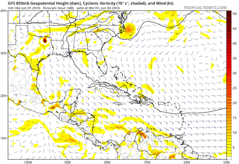
https://i.imgsafe.org/e8cd5a29d4.png
vort
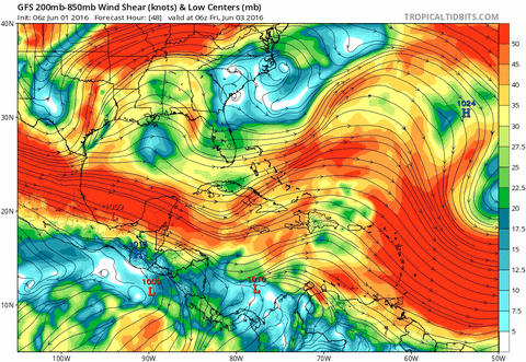
https://i.imgsafe.org/e8d9adb2cc.png
shear
0 likes

Re: 2016 Global Model Runs Discussion
That shows an outflow jet with a system in the proper quad....interesting run of the euro
0 likes
-
cycloneye

- Admin

- Posts: 149410
- Age: 69
- Joined: Thu Oct 10, 2002 10:54 am
- Location: San Juan, Puerto Rico
Re: 2016 Global Model Runs Discussion
06z GFS more stronger.

0 likes
Visit the Caribbean-Central America Weather Thread where you can find at first post web cams,radars
and observations from Caribbean basin members Click Here
and observations from Caribbean basin members Click Here
-
Kingarabian

- S2K Supporter

- Posts: 16355
- Joined: Sat Aug 08, 2009 3:06 am
- Location: Honolulu, Hawaii
Re: 2016 Global Model Runs Discussion
Seems like this system has too small of a window for development. Hopefully this means that at most this will be a TS.
The posts in this forum are NOT official forecast and should not be used as such. They are just the opinion of the poster and may or may not be backed by sound meteorological data. They are NOT endorsed by any professional institution or storm2k.org. For official information, please refer to the NHC and NWS products.[
The posts in this forum are NOT official forecast and should not be used as such. They are just the opinion of the poster and may or may not be backed by sound meteorological data. They are NOT endorsed by any professional institution or storm2k.org. For official information, please refer to the NHC and NWS products.[
0 likes
RIP Kobe Bryant
-
Dean4Storms
- S2K Supporter
- Posts: 6358
- Age: 63
- Joined: Sun Aug 31, 2003 1:01 pm
- Location: Miramar Bch. FL
Re: 2016 Global Model Runs Discussion
Shear and dry air to its NW will be limiting factors I believe.
0 likes
-
TheStormExpert
Re: 2016 Global Model Runs Discussion
Interesting to note that the 06z GFS brings the energy from the East Pacific starting @ 48hrs. or so and crosses it over into the Western Caribbean @ 126hrs. or so where it develops into a moderate strength TS that hits extreme S. FL @ 192hrs. The key with this run is that it keeps the low far enough south in the GoM to avoid the strongest wind shear and also has it sitting right under an anticyclone the whole time verses previous runs where it didn't.
0 likes

Re: 2016 Global Model Runs Discussion
My initial thoughts are that these early season Caribbean and GOM systems have problems organizing quickly and usually become rain threats more than anything.
Well see if this one can get a little stronger (like the GFS) shows but I'm skeptical.
Well see if this one can get a little stronger (like the GFS) shows but I'm skeptical.
0 likes
-
cycloneye
- Admin
- Posts: 149410
- Age: 69
- Joined: Thu Oct 10, 2002 10:54 am
- Location: San Juan, Puerto Rico
Re: 2016 Global Model Runs Discussion
Levi Cowen's take on initial focus of any possible development.
TropicalTidbits · 10m10 minutes ago
Trade wind "burst" pattern will lead to heavy rain progressing into western Caribbean and possibly Florida next week.
@TropicalTidbits · 5m5 minutes ago
Models will consistently overestimate the ability of this type of pattern to produce a bonafide TC. Gotta play the waiting game here.
0 likes
Visit the Caribbean-Central America Weather Thread where you can find at first post web cams,radars
and observations from Caribbean basin members Click Here
and observations from Caribbean basin members Click Here
Re: 2016 Global Model Runs Discussion
RL3AO wrote:My initial thoughts are that these early season Caribbean and GOM systems have problems organizing quickly and usually become rain threats more than anything.
Well see if this one can get a little stronger (like the GFS) shows but I'm skeptical.
Agree. I'm watching for the moisture plume...2+" PWATS and seabreeze/outflow collisions can yield some weather more spectacular than a low end TC. And the gun reloads everyday. That's why if you want better lightning climo than portions of the Florida peninsula... you need a passport.
0 likes
-
jlauderdal
- S2K Supporter
- Posts: 7240
- Joined: Wed May 19, 2004 5:46 am
- Location: NE Fort Lauderdale
- Contact:
Re: 2016 Global Model Runs Discussion
do not get sucked into the gfs development trap...the gfs has been developing systems and hitting sofla for years,,,until it can actually nail something outside of 72 hours be very cautious
0 likes
-
TheStormExpert
-
gatorcane

- S2K Supporter
- Posts: 23708
- Age: 48
- Joined: Sun Mar 13, 2005 3:54 pm
- Location: Boca Raton, FL
Re: 2016 Global Model Runs Discussion
TheStormExpert wrote:And just like that the 12z GFS drops development.
Seems to me the GFS has trended closer to the ECMWF on possible development of a Caribbean low in about 5 days from now (not EPAC crossover in the long-range which seems unrealistic). There is some land interaction on this run so that might hinder development. Do note the upper anti-cyclone sitting over the NW Caribbean just east of the low.


0 likes
-
TheStormExpert
-
gatorcane
- S2K Supporter
- Posts: 23708
- Age: 48
- Joined: Sun Mar 13, 2005 3:54 pm
- Location: Boca Raton, FL
Re: 2016 Global Model Runs Discussion
12Z NAVGEM (not a great model so take with a grain of salt):

12Z CMC (usually an overbullish model):

12Z CMC (usually an overbullish model):
0 likes
-
SFLcane

- S2K Supporter
- Posts: 10281
- Age: 48
- Joined: Sat Jun 05, 2010 1:44 pm
- Location: Lake Worth Florida
Re: 2016 Global Model Runs Discussion
Looks likes gets absorbed into front messy rainy in Florida. Not sold on development.
0 likes
-
tarheelprogrammer

- S2K Supporter
- Posts: 1793
- Joined: Mon Mar 28, 2016 9:25 pm
- Location: Raleigh, NC area (Garner, NC)
Re: 2016 Global Model Runs Discussion
GEFS more aggressive with development. Hmmmmmmmmm.
0 likes
My posts are not official forecasts. They are just my opinion and may or may not be backed by sound meteorological data. They are NOT endorsed by any professional institution or storm2k.org. For official information, please refer to the NHC and NWS products.
-
tropicwatch

- Category 5
- Posts: 3426
- Age: 62
- Joined: Sat Jun 02, 2007 10:01 am
- Location: The Villages, Florida
- Contact:
Re: 2016 Global Model Runs Discussion
As always, timing of the front and anything in the gulf will be the determining factor. I am kind of surprised at the fronts coming through so forcefully this time of year.
0 likes
Tropicwatch
Agnes 72', Eloise 75, Elena 85', Kate 85', Charley 86', Florence 88', Beryl 94', Dean 95', Erin 95', Opal 95', Earl 98', Georges 98', Ivan 2004', Arlene 2005', Dennis 2005', Ida 2009' Debby 2012' Irma 2017' Michael 2018'
Agnes 72', Eloise 75, Elena 85', Kate 85', Charley 86', Florence 88', Beryl 94', Dean 95', Erin 95', Opal 95', Earl 98', Georges 98', Ivan 2004', Arlene 2005', Dennis 2005', Ida 2009' Debby 2012' Irma 2017' Michael 2018'
-
floridasun78
- Category 5
- Posts: 3755
- Joined: Sun May 17, 2009 10:16 pm
- Location: miami fl

Who is online
Users browsing this forum: Ntxw, WaveBreaking and 353 guests