2016 EPAC Season

This is the general tropical discussion area. Anyone can take their shot at predicting a storms path.

Moderator: S2k Moderators

Forum rules

The posts in this forum are NOT official forecasts and should not be used as such. They are just the opinion of the poster and may or may not be backed by sound meteorological data. They are NOT endorsed by any professional institution or STORM2K. For official information, please refer to products from the National Hurricane Center and National Weather Service.

Help Support Storm2K
Message
Author
User avatar
AJC3
Admin
Admin
Posts: 3999
Age: 61
Joined: Tue Aug 31, 2004 7:04 pm
Location: Ballston Spa, New York
Contact:

Re: 2016 EPAC Season: 12z GFS running

#341 Postby AJC3 » Tue Jun 28, 2016 11:48 am

cycloneye wrote:Tony,lower than that,922 mbs. Is the lowest on this run.


I suspect Levi's web site probably has native output from the 13KM GFS, which would explain the lower MCP.
I believe our GRIB files are resampled to 20KM due to bandwidth constraints.
0 likes   

User avatar
cycloneye
Admin
Admin
Posts: 145358
Age: 68
Joined: Thu Oct 10, 2002 10:54 am
Location: San Juan, Puerto Rico

Re: 2016 EPAC Season: 12z GFS running

#342 Postby cycloneye » Tue Jun 28, 2016 11:51 am

AJC3 wrote:
cycloneye wrote:Tony,lower than that,922 mbs. Is the lowest on this run.


I suspect Levi's web site probably has native output from the 13KM GFS, which would explain the lower MCP.
I believe our GRIB files are resampled to 20KM due to bandwidth constraints.


In any case on whatever resolution,we may be seeing a beautiful powerful hurricane to track in open waters.
0 likes   
Visit the Caribbean-Central America Weather Thread where you can find at first post web cams,radars
and observations from Caribbean basin members Click Here

User avatar
cycloneye
Admin
Admin
Posts: 145358
Age: 68
Joined: Thu Oct 10, 2002 10:54 am
Location: San Juan, Puerto Rico

Re: 2016 EPAC Season: 12z GFS running

#343 Postby cycloneye » Tue Jun 28, 2016 11:55 am

The MJO / Kelvin Wave will help to do this and other developments behind.
0 likes   
Visit the Caribbean-Central America Weather Thread where you can find at first post web cams,radars
and observations from Caribbean basin members Click Here

User avatar
Ntxw
Storm2k Moderator
Storm2k Moderator
Posts: 22786
Joined: Wed Oct 21, 2009 6:34 pm
Location: DFW, Texas

Re: 2016 EPAC Season: 12z GFS running

#344 Postby Ntxw » Tue Jun 28, 2016 11:58 am

Yeah CCKW passage will be beneficial. I like the odds for an open water, satellite eye candy.
0 likes   
The above post and any post by Ntxw is NOT an official forecast and should not be used as such. It is just the opinion of the poster and may or may not be backed by sound meteorological data. It is NOT endorsed by any professional institution including Storm2k. For official information, please refer to NWS products.

  Help support Storm2K!
Help Support Storm2K

User avatar
cycloneye
Admin
Admin
Posts: 145358
Age: 68
Joined: Thu Oct 10, 2002 10:54 am
Location: San Juan, Puerto Rico

Re: 2016 EPAC Season

#345 Postby cycloneye » Tue Jun 28, 2016 12:07 pm

CPC has it in red and has longer range possible developments.

Image
0 likes   
Visit the Caribbean-Central America Weather Thread where you can find at first post web cams,radars
and observations from Caribbean basin members Click Here

User avatar
Yellow Evan
Professional-Met
Professional-Met
Posts: 16143
Age: 27
Joined: Fri Jul 15, 2011 12:48 pm
Location: Henderson, Nevada/Honolulu, HI
Contact:

Re: 2016 EPAC Season

#346 Postby Yellow Evan » Tue Jun 28, 2016 12:11 pm

Longer range storms:

Image

Image

3 more behind the Cat 5 total
0 likes   

User avatar
Yellow Evan
Professional-Met
Professional-Met
Posts: 16143
Age: 27
Joined: Fri Jul 15, 2011 12:48 pm
Location: Henderson, Nevada/Honolulu, HI
Contact:

Re: 2016 EPAC Season

#347 Postby Yellow Evan » Tue Jun 28, 2016 12:18 pm

0z EPS seems to like the first system the 0z ECMWF shows more and most members barely develops the system the GFS is showing, at least for another 8 days.

Is very bullish in the long range.
0 likes   

User avatar
cycloneye
Admin
Admin
Posts: 145358
Age: 68
Joined: Thu Oct 10, 2002 10:54 am
Location: San Juan, Puerto Rico

Re: 2016 EPAC Season

#348 Postby cycloneye » Tue Jun 28, 2016 12:31 pm

Up to 50% in 5 days

TROPICAL WEATHER OUTLOOK
NWS NATIONAL HURRICANE CENTER MIAMI FL
1100 AM PDT TUE JUN 28 2016

For the eastern North Pacific...east of 140 degrees west longitude:

A westward-moving tropical wave has moved into the eastern North
Pacific basin and is producing disorganized shower activity. A
broad area of low pressure is expected to form in association
with this wave south of the Gulf of Tehuantepec by Thursday.
Environmental conditions are forecast to be conducive for gradual
development of the disturbance, and a tropical depression could form
over the weekend while the system moves generally westward at 10 to
15 mph, remaining well offshore of the coast of Mexico.
* Formation chance through 48 hours...low...near 0 percent
* Formation chance through 5 days...medium...50 percent

$$
Forecaster Stewart


Image
0 likes   
Visit the Caribbean-Central America Weather Thread where you can find at first post web cams,radars
and observations from Caribbean basin members Click Here

User avatar
Yellow Evan
Professional-Met
Professional-Met
Posts: 16143
Age: 27
Joined: Fri Jul 15, 2011 12:48 pm
Location: Henderson, Nevada/Honolulu, HI
Contact:

Re: 2016 EPAC Season: 11 AM PDT TWO up to 50% in 5 days

#349 Postby Yellow Evan » Tue Jun 28, 2016 12:36 pm

I wouldn't have raised it to 50% until the ECMWF has a better grip on the 2 systems (the first one the ECMWF has, and the GFS one) since as of now if the ECMWF is correct, the 0/50 one won't develop for a while.
0 likes   

User avatar
cycloneye
Admin
Admin
Posts: 145358
Age: 68
Joined: Thu Oct 10, 2002 10:54 am
Location: San Juan, Puerto Rico

Re: 2016 EPAC Season

#350 Postby cycloneye » Tue Jun 28, 2016 1:46 pm

The NHC folks will have to think hard which model to follow between the fast developer and very strong GFS and the slower and weaker ECMWF.
0 likes   
Visit the Caribbean-Central America Weather Thread where you can find at first post web cams,radars
and observations from Caribbean basin members Click Here

User avatar
Yellow Evan
Professional-Met
Professional-Met
Posts: 16143
Age: 27
Joined: Fri Jul 15, 2011 12:48 pm
Location: Henderson, Nevada/Honolulu, HI
Contact:

Re: 2016 EPAC Season

#351 Postby Yellow Evan » Tue Jun 28, 2016 1:51 pm

Image

12z ECMWF develops the first system further left and the GFS system very slowly. With that said, I have a little less trust in the ECMWF than usual since it seems very erratic.
0 likes   

User avatar
cycloneye
Admin
Admin
Posts: 145358
Age: 68
Joined: Thu Oct 10, 2002 10:54 am
Location: San Juan, Puerto Rico

Re: 2016 EPAC Season

#352 Postby cycloneye » Tue Jun 28, 2016 2:40 pm

GEFS ensembles.

Image
0 likes   
Visit the Caribbean-Central America Weather Thread where you can find at first post web cams,radars
and observations from Caribbean basin members Click Here

User avatar
cycloneye
Admin
Admin
Posts: 145358
Age: 68
Joined: Thu Oct 10, 2002 10:54 am
Location: San Juan, Puerto Rico

Re: 2016 EPAC Season

#353 Postby cycloneye » Tue Jun 28, 2016 3:17 pm

Yellow Evan,are you surprised NHC didn't mentioned the more western system?
0 likes   
Visit the Caribbean-Central America Weather Thread where you can find at first post web cams,radars
and observations from Caribbean basin members Click Here

User avatar
Yellow Evan
Professional-Met
Professional-Met
Posts: 16143
Age: 27
Joined: Fri Jul 15, 2011 12:48 pm
Location: Henderson, Nevada/Honolulu, HI
Contact:

Re: 2016 EPAC Season

#354 Postby Yellow Evan » Tue Jun 28, 2016 3:21 pm

cycloneye wrote:Yellow Evan,are you surprised NHC didn't mentioned the more western system?


No, I've seen plenty of instances on models during the start of MJO pulses where the models falsely detect a weaker system forming next to a more robust system (this happened in 2013 a couple times for instance), so it's best to wait for more consistency among multiple models.
0 likes   

User avatar
Kingarabian
S2K Supporter
S2K Supporter
Posts: 15981
Joined: Sat Aug 08, 2009 3:06 am
Location: Honolulu, Hawaii

Re: 2016 EPAC Season

#355 Postby Kingarabian » Tue Jun 28, 2016 3:31 pm

cycloneye wrote:Yellow Evan,are you surprised NHC didn't mentioned the more western system?


I'ts tough on NHC's part.The Euro has been strangely very erratic at the moment and its EPS members are all over the place.

The GFS has been trying to develop this wave for a while now - first in the GOM and now in the Pacific. And I've never seen its ensemble members be super tightly clustered in accordance with the operational model in the medium - long range.

That being said, as the timeframe comes closer hopefully things will become clearer. Logically, Knowing the GFS and its trends this year, I wouldn't be surprised if it caves in to the Euro. But my gut is saying it won't happen because it's ensembles are in excellent agreement with the operational model, and the European has been the exact opposite.

That being said, both models show TC formation one or other and I'm excited to see the season's first storm.
0 likes   
RIP Kobe Bryant

User avatar
Yellow Evan
Professional-Met
Professional-Met
Posts: 16143
Age: 27
Joined: Fri Jul 15, 2011 12:48 pm
Location: Henderson, Nevada/Honolulu, HI
Contact:

Re: 2016 EPAC Season

#356 Postby Yellow Evan » Tue Jun 28, 2016 3:32 pm

:uarrow: 12z EPS members have shifted east seem a lot more focused on the GFS system. Maybe its caving to the GFS?
0 likes   

User avatar
Yellow Evan
Professional-Met
Professional-Met
Posts: 16143
Age: 27
Joined: Fri Jul 15, 2011 12:48 pm
Location: Henderson, Nevada/Honolulu, HI
Contact:

Re: 2016 EPAC Season

#357 Postby Yellow Evan » Tue Jun 28, 2016 5:19 pm

Image

18 GFs through day six
0 likes   

stormwise

Re: 2016 EPAC Season

#358 Postby stormwise » Tue Jun 28, 2016 5:21 pm

NDG wrote:
stormwise wrote:https://i.imgsafe.org/226d3f21f1.gif
Strong signal.


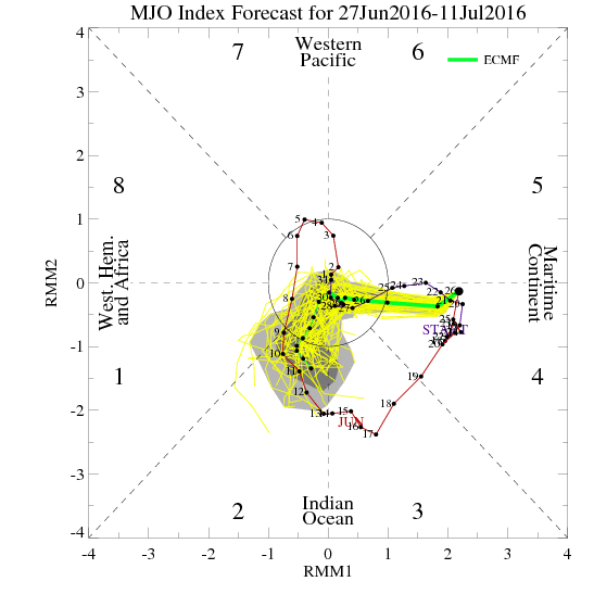
I wouldn't bet not even a penny on the NCEP model being correct with the MJO.
The Euro usually does a better job forecasting the MJO.

Image


I would.
Image
Last edited by stormwise on Wed Jun 29, 2016 1:06 am, edited 2 times in total.
0 likes   

User avatar
Yellow Evan
Professional-Met
Professional-Met
Posts: 16143
Age: 27
Joined: Fri Jul 15, 2011 12:48 pm
Location: Henderson, Nevada/Honolulu, HI
Contact:

Re: 2016 EPAC Season

#359 Postby Yellow Evan » Tue Jun 28, 2016 5:33 pm

Image

18z GFs through day 8.
0 likes   

User avatar
cycloneye
Admin
Admin
Posts: 145358
Age: 68
Joined: Thu Oct 10, 2002 10:54 am
Location: San Juan, Puerto Rico

Re: 2016 EPAC Season

#360 Postby cycloneye » Tue Jun 28, 2016 5:34 pm

So far is only one system.
0 likes   
Visit the Caribbean-Central America Weather Thread where you can find at first post web cams,radars
and observations from Caribbean basin members Click Here


Return to “Talkin' Tropics”

Who is online

Users browsing this forum: Tx_Summer and 29 guests