Seasonal Indicators (Beyond Day 16): Instability / SST's / MSLP / Steering / Sal

This is the general tropical discussion area. Anyone can take their shot at predicting a storms path.

Moderator: S2k Moderators

Forum rules

The posts in this forum are NOT official forecasts and should not be used as such. They are just the opinion of the poster and may or may not be backed by sound meteorological data. They are NOT endorsed by any professional institution or STORM2K. For official information, please refer to products from the National Hurricane Center and National Weather Service.

Help Support Storm2K
Message
Author
TheStormExpert

Re: Seasonal Indicators (Beyond Day 16): Instability / SST's / MSLP / Steering / Sal

#1081 Postby TheStormExpert » Tue Jul 19, 2016 1:11 am

Hammy wrote:
TheStormExpert wrote:
Hammy wrote:Models showing abnormally high shear returning in a week or so basin-wide. Combined with the waves continuing to come up at almost 20N, and a return of Pacific activity as per the last several runs, I don't see anything forming for another month or so. I'm having doubts about my 1998 analog as well given that I don't recall the ITCZ being nearly this far north over Africa, nor do I remember the shear being high in late July/early August over the western part of the basin.

August is supposed to be one of the busiest months of any given hurricane season and if wind shear is high it is basically game over!

Not trying to just cry season cancel but the models are really starting to make it hard for me to believe a 1998 redux when the East Pacific just won't let up.


I'm still thinking 1998 is the most likely -at the moment- but am a bit less sure--I don't have model runs to compare to, nor do I have actual instability/upper air/moisture/low level flow charts to compare this year to for certainty one way or the other, only memory. The positioning of the ITCZ is certainly the biggest source of my doubt at the moment though, the lows are coming off far too north as even in the best of conditions the waters are too cool. The shear though will certainly shut down the western half of the basin for the next several weeks if it plays out.

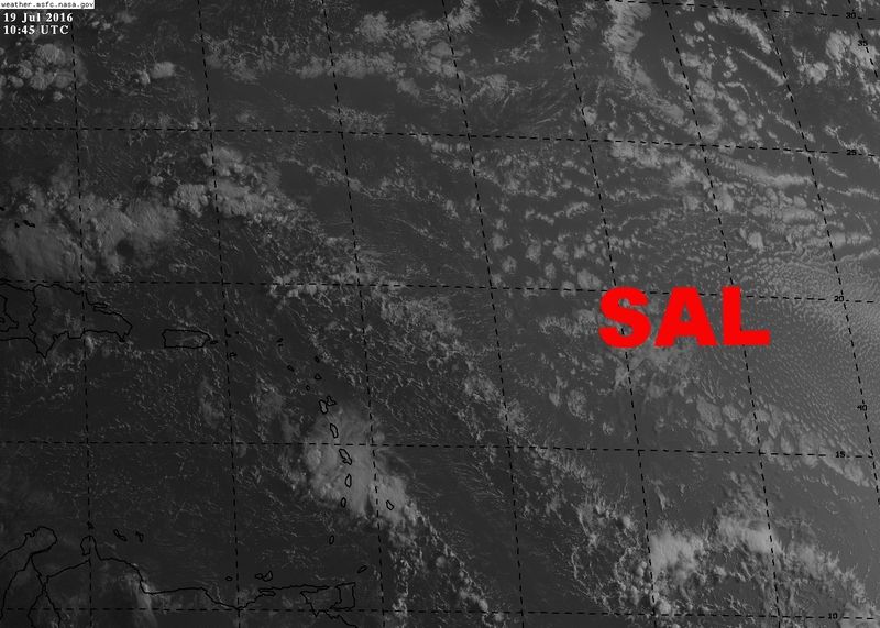
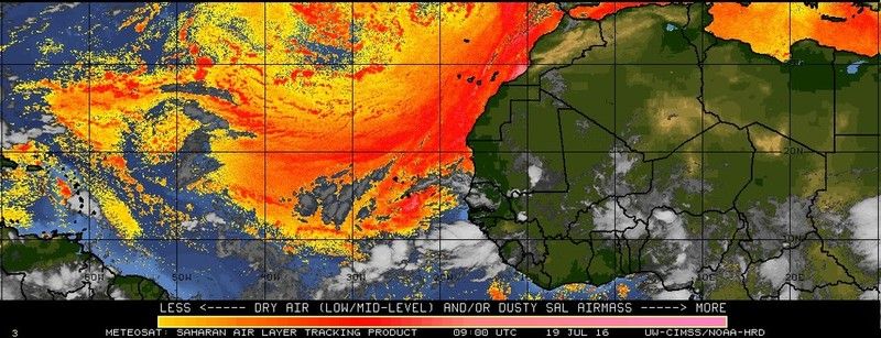
Yeah it makes no sense why these waves are coming off so far north in latitude where waters are too cool to support even the slightest tropical development, therefore the waves just fizzle out and die not only due to the cooler waters but the dry air, and sal that's high in that region.

If we don't have waves to track then forget anything developing in the Western Atlantic, Caribbean, or Gulf of Mexico where conditions could still be hostile with strong wind shear.

Really would like to also hear some feedback from a Pro-Met as to what they see happening from here on out since conditions aren't looking too good out there.
0 likes   

User avatar
chaser1
S2K Supporter
S2K Supporter
Posts: 5472
Age: 64
Joined: Sat Oct 15, 2005 5:59 pm
Location: Longwood, Fl

Re: Seasonal Indicators (Beyond Day 16): Instability / SST's / MSLP / Steering / Sal

#1082 Postby chaser1 » Tue Jul 19, 2016 3:12 am

I'm seeing an upper level flow conditions as being more conducive than a number of others posting here. Then again, I'm noticing a 200mb flow which seems cellular and pretty progressive. I"m also noting that for the most part, upper level conditions seem much less a result of residual El Nino conditions. In this still transitioning part of the season I'm NOT looking at those obvious areas where long range upper level shear might appear foreboding. I know well enough that Tropical cyclone formation is far less likely to occur under inhaspitable conditions. In fact, while others tend to look at those areas of more hostile conditions and assume "well, nothin's gonna form there", I"m doing the opposite and looking at those areas where upper level conditions seem far more optimal and am then simply looking for the next wave thats looking for that "sweet spot".

As for those who insist that tropical waves simply go "poof" into the night - they really dont. They may dry out, they may become unconvective, but they'll typically flare up again. Thats why I'm just not sweating it. It remains to be seen but even if the E. Atlantic has sinking air. Now, add a bit of upper level shear and for good measure lets pretend that SST's were below normal east of the CV Islands. All this means to me is that formation is simply going to occur at point further west. From that, I'll then guess that there will be also be a greater number of landfall impacts over the 3 months during prime time.
0 likes   
Andy D

(For official information, please refer to the NHC and NWS products.)

User avatar
Hammy
Category 5
Category 5
Posts: 5849
Age: 42
Joined: Fri May 25, 2012 5:25 pm
Contact:

Re: Seasonal Indicators (Beyond Day 16): Instability / SST's / MSLP / Steering / Sal

#1083 Postby Hammy » Tue Jul 19, 2016 4:06 am

chaser1 wrote:I'm seeing an upper level flow conditions as being more conducive than a number of others posting here. Then again, I'm noticing a 200mb flow which seems cellular and pretty progressive. I"m also noting that for the most part, upper level conditions seem much less a result of residual El Nino conditions. In this still transitioning part of the season I'm NOT looking at those obvious areas where long range upper level shear might appear foreboding. I know well enough that Tropical cyclone formation is far less likely to occur under inhaspitable conditions. In fact, while others tend to look at those areas of more hostile conditions and assume "well, nothin's gonna form there", I"m doing the opposite and looking at those areas where upper level conditions seem far more optimal and am then simply looking for the next wave thats looking for that "sweet spot".

As for those who insist that tropical waves simply go "poof" into the night - they really dont. They may dry out, they may become unconvective, but they'll typically flare up again. Thats why I'm just not sweating it. It remains to be seen but even if the E. Atlantic has sinking air. Now, add a bit of upper level shear and for good measure lets pretend that SST's were below normal east of the CV Islands. All this means to me is that formation is simply going to occur at point further west. From that, I'll then guess that there will be also be a greater number of landfall impacts over the 3 months during prime time.


This is the shear increase I mentioned.

http://i.imgur.com/eJfcohr.png
http://i.imgur.com/aNm2SLZ.png
http://i.imgur.com/5O4dqmN.png

My doubt concerning the waves is that they are coming off at far too high a latitude, and then being shoved southwest along with the dry air they're bringing with them, which is serving to both stabilize the Atlantic and preventing the waves (which are decent pressure-wise) from doing much to start with due to water temperatures.
0 likes   
The above post is not official and should not be used as such. It is the opinion of the poster and may or may not be backed by sound meteorological data. It is not endorsed by any professional institution or storm2k.org. For official information, please refer to the NHC and NWS products.

ninel conde

Re: Seasonal Indicators (Beyond Day 16): Instability / SST's / MSLP / Steering / Sal

#1084 Postby ninel conde » Tue Jul 19, 2016 4:52 am

Might be awile before we see a wave make it to 60 west with a thunderstorm. That will be the first sign the pattern has modified a bit.
0 likes   

User avatar
Hammy
Category 5
Category 5
Posts: 5849
Age: 42
Joined: Fri May 25, 2012 5:25 pm
Contact:

Re: Seasonal Indicators (Beyond Day 16): Instability / SST's / MSLP / Steering / Sal

#1085 Postby Hammy » Tue Jul 19, 2016 5:05 am

ninel conde wrote:Might be awile before we see a wave make it to 60 west with a thunderstorm. That will be the first sign the pattern has modified a bit.


Your wait is already over.

Image

I've noticed this morning there is more convection in the western Atlantic than we've seen in quite some time.
0 likes   
The above post is not official and should not be used as such. It is the opinion of the poster and may or may not be backed by sound meteorological data. It is not endorsed by any professional institution or storm2k.org. For official information, please refer to the NHC and NWS products.

ninel conde

Re: Seasonal Indicators (Beyond Day 16): Instability / SST's / MSLP / Steering / Sal

#1086 Postby ninel conde » Tue Jul 19, 2016 5:09 am

Hammy wrote:
ninel conde wrote:Might be awile before we see a wave make it to 60 west with a thunderstorm. That will be the first sign the pattern has modified a bit.


Your wait is already over.

Image

I've noticed this morning there is more convection in the western Atlantic than we've seen in quite some time.


There is a bit more but im wondering if its being caused by upper level troughiness.
0 likes   

User avatar
NDG
S2K Supporter
S2K Supporter
Posts: 15446
Joined: Sun Jul 09, 2006 10:14 pm
Location: Orlando, FL

Re: Seasonal Indicators (Beyond Day 16): Instability / SST's / MSLP / Steering / Sal

#1087 Postby NDG » Tue Jul 19, 2016 6:40 am

Lots of SAL controlling the MDR. A few days ago I thought we would see the Atlantic basin fire up by the end of this month with the MJO visiting our part of the world but I just don't see that happening for the remainder of the month with so much Saharan dust and warm layer controlling it. The only way is if a strong tropical wave is able to survive and move to either the NW Caribbean, GOM or the Bahamas area where it may have a chance to develop.

You can clearly see the SAL on this morning visible satellite pix to the NE of the tropical wave entering the Caribbean this morning.

Image
Image
0 likes   


User avatar
NDG
S2K Supporter
S2K Supporter
Posts: 15446
Joined: Sun Jul 09, 2006 10:14 pm
Location: Orlando, FL

Re: Seasonal Indicators (Beyond Day 16): Instability / SST's / MSLP / Steering / Sal

#1089 Postby NDG » Tue Jul 19, 2016 6:54 am


First link to the article is full of crap, clearly Saharan dust has not trended downward over the years, IMO.
0 likes   

TheStormExpert

Re: Seasonal Indicators (Beyond Day 16): Instability / SST's / MSLP / Steering / Sal

#1090 Postby TheStormExpert » Tue Jul 19, 2016 6:57 am

My question is will the SAL continue to kill the 2016 hurricane season or will it vanish some in the coming weeks?
0 likes   

stormwise

Re: Seasonal Indicators (Beyond Day 16): Instability / SST's / MSLP / Steering / Sal

#1091 Postby stormwise » Tue Jul 19, 2016 6:59 am

NDG wrote:


First link to the article is full of crap, clearly Saharan dust has not trended downward over the years, IMO.


Thanks nice way of saying you don't agree, u having a bad day?
0 likes   

User avatar
WPBWeather
S2K Supporter
S2K Supporter
Posts: 535
Age: 67
Joined: Thu Jul 18, 2013 12:33 pm

Re: Seasonal Indicators (Beyond Day 16): Instability / SST's / MSLP / Steering / Sal

#1092 Postby WPBWeather » Tue Jul 19, 2016 7:02 am

TheStormExpert wrote:My question is will the SAL continue to kill the 2016 hurricane season or will it vanish some in the coming weeks?


It will vanish as it ALWAYS does.
0 likes   

User avatar
NDG
S2K Supporter
S2K Supporter
Posts: 15446
Joined: Sun Jul 09, 2006 10:14 pm
Location: Orlando, FL

Re: Seasonal Indicators (Beyond Day 16): Instability / SST's / MSLP / Steering / Sal

#1093 Postby NDG » Tue Jul 19, 2016 7:17 am

stormwise wrote:
NDG wrote:


First link to the article is full of crap, clearly Saharan dust has not trended downward over the years, IMO.


Thanks nice way of saying you don't agree, u having a bad day?


Actually, I should had said both articles are full of crap. Clearly during the past couple of years the Saharan dust has been on the increase.
0 likes   

User avatar
WPBWeather
S2K Supporter
S2K Supporter
Posts: 535
Age: 67
Joined: Thu Jul 18, 2013 12:33 pm

Re: Seasonal Indicators (Beyond Day 16): Instability / SST's / MSLP / Steering / Sal

#1094 Postby WPBWeather » Tue Jul 19, 2016 7:21 am

NDG wrote:
stormwise wrote:
NDG wrote:
First link to the article is full of crap, clearly Saharan dust has not trended downward over the years, IMO.


Thanks nice way of saying you don't agree, u having a bad day?


Actually, I should had said both articles are full of crap. Clearly during the past couple of years the Saharan dust has been on the increase.


Not to start an argument, but do you have any evidence or just an opinion of the levels of SAL?
0 likes   

stormwise

Re: Seasonal Indicators (Beyond Day 16): Instability / SST's / MSLP / Steering / Sal

#1095 Postby stormwise » Tue Jul 19, 2016 7:28 am

https://i.imgsafe.org/e1b4aa7942.png

https://i.imgsafe.org/e1bfec6662.png

cfsv2 indicating quite a change over 7 days if it verifys .
0 likes   

User avatar
NDG
S2K Supporter
S2K Supporter
Posts: 15446
Joined: Sun Jul 09, 2006 10:14 pm
Location: Orlando, FL

Re: Seasonal Indicators (Beyond Day 16): Instability / SST's / MSLP / Steering / Sal

#1096 Postby NDG » Tue Jul 19, 2016 7:28 am

WPBWeather wrote:
NDG wrote:
stormwise wrote:
Thanks nice way of saying you don't agree, u having a bad day?


Actually, I should had said both articles are full of crap. Clearly during the past couple of years the Saharan dust has been on the increase.


Not to start an argument, but do you have any evidence or just an opinion of the levels of SAL?
.

I have as much evidence as both articles state. Yes, I agree that during the late 90s into the 2000s SAL did drop thus the much higher hurricane activity, but during the last few years a stronger Atlantic subtropical ridge was brought the SAL outbreaks back during this time of the year. Which makes sense, if indeed the AMO has now turned negative as per Dr Phil K these SAL outbreaks will be the norm once again as during the 80s and other periods when the AMO has been negative.
0 likes   

User avatar
JaxGator
Category 2
Category 2
Posts: 780
Joined: Sun Jun 12, 2016 3:33 pm
Location: Jacksonville Florida

Re: Seasonal Indicators (Beyond Day 16): Instability / SST's / MSLP / Steering / Sal

#1097 Postby JaxGator » Tue Jul 19, 2016 7:31 am

Imo, the SAL now doesn't look as bad as past years, though it is still dominate.
0 likes   
The posts or stuff said are NOT an official forecast. Please look to the NHC and NWS for official forecasts and products.

Floyd-1999, Frances-2004, Jeanne-2004, Fay-2008, Beryl-2012, Debby-2012, Colin-2016, Hermine-2016, Julia-2016, Matthew-2016, Irma-2017, Elsa-2021, Idalia-2023, Debby-2024, Helene-2024.


Go Gators! Go Jags!

User avatar
JaxGator
Category 2
Category 2
Posts: 780
Joined: Sun Jun 12, 2016 3:33 pm
Location: Jacksonville Florida

Re: Seasonal Indicators (Beyond Day 16): Instability / SST's / MSLP / Steering / Sal

#1098 Postby JaxGator » Tue Jul 19, 2016 7:36 am

Hasn't the AMO been going up this year (per hurricanetrack)?
0 likes   
The posts or stuff said are NOT an official forecast. Please look to the NHC and NWS for official forecasts and products.

Floyd-1999, Frances-2004, Jeanne-2004, Fay-2008, Beryl-2012, Debby-2012, Colin-2016, Hermine-2016, Julia-2016, Matthew-2016, Irma-2017, Elsa-2021, Idalia-2023, Debby-2024, Helene-2024.


Go Gators! Go Jags!

User avatar
NDG
S2K Supporter
S2K Supporter
Posts: 15446
Joined: Sun Jul 09, 2006 10:14 pm
Location: Orlando, FL

Re: Seasonal Indicators (Beyond Day 16): Instability / SST's / MSLP / Steering / Sal

#1099 Postby NDG » Tue Jul 19, 2016 7:36 am

JaxGator wrote:Imo, the SAL now doesn't look as bad as past years, though it is still dominate.


Saharan dust has made it all the way to Texas this year, I call that pretty bad for this year.
0 likes   

TheStormExpert

Re: Seasonal Indicators (Beyond Day 16): Instability / SST's / MSLP / Steering / Sal

#1100 Postby TheStormExpert » Tue Jul 19, 2016 7:44 am

NDG, what's your thoughts on wind shear throughout the Atlantic in the coming weeks?
0 likes   


Return to “Talkin' Tropics”

Who is online

Users browsing this forum: Ian2401, JtSmarts and 50 guests