Wave between Bermuda and Greater Antilles
Moderator: S2k Moderators
Forum rules

The posts in this forum are NOT official forecasts and should not be used as such. They are just the opinion of the poster and may or may not be backed by sound meteorological data. They are NOT endorsed by any professional institution or STORM2K. For official information, please refer to products from the National Hurricane Center and National Weather Service.
-
SEASON_CANCELED

- Category 3

- Posts: 887
- Joined: Mon Jul 06, 2009 5:17 am
- Location: 8 Bit Charlie Sheen
Re: Wave in far East Atlantic
Just modelstorms. GFS turning clouds in to jupiter great red spots like old times. I've seen some monsters before...never forget 2005. You would of thought the world was ending!
1 likes
i am a big stupid ugly moron with an ugly face and a big butt and my butt stinks and i like to kiss my own butt
-
TheStormExpert
Re: Wave in far East Atlantic
You can track the vorticity of this wave on the latest 00z Euro as it tracks directly over the Greater Antilles and into the Florida Peninsula. Has the look like it wants to try and spin up prior to running into Hispaniola when it reaches the NE Caribbean. After it exits Florida to the NE it is so stretched out and weak from tracking over so many land masses that development seems unlikely.
The GFS does not show this so it may be the Euro being overly aggressive again.

The GFS does not show this so it may be the Euro being overly aggressive again.
0 likes

Re: Wave in far East Atlantic
TheStormExpert wrote:You can track the vorticity of this wave on the latest 00z Euro as it tracks directly over the Greater Antilles and into the Florida Peninsula. Has the look like it wants to try and spin up prior to running into Hispaniola when it reaches the NE Caribbean. After it exits Florida to the NE it is so stretched out and weak from tracking over so many land masses that development seems unlikely.
The GFS does not show this so it may be the Euro being overly aggressive again.
Interesting to note though, the Euro showed almost the exact same scenario with 97L back when it was in the eastern Atlantic. It's quite poor at detecting development beyond about 72-96 hours.
0 likes
The above post is not official and should not be used as such. It is the opinion of the poster and may or may not be backed by sound meteorological data. It is not endorsed by any professional institution or storm2k.org. For official information, please refer to the NHC and NWS products.


Re: Wave in far East Atlantic
This wave has started to get its act together ,and should be a concern for the Windward and Leeward islands ,as there is a high pressure system in place.
0 likes
-
Dean4Storms
- S2K Supporter

- Posts: 6358
- Age: 63
- Joined: Sun Aug 31, 2003 1:01 pm
- Location: Miramar Bch. FL
Re: Wave in far East Atlantic
This wave looks better this morning and concentrated convection. I think this one could be trouble for the eastern Carib. Islands.
0 likes
-
alienstorm

- Category 1

- Posts: 496
- Joined: Tue Jul 31, 2007 1:29 pm
- Location: Miami Fla western suburb
Re: Wave in far East Atlantic
Conditions are to hostile for any development, there is a huge ULL in the Atlantic that is causing shear and it is forecast to get worse.
1 likes
Personal Forecast Disclaimer:The posts in this forum are NOT official forecast and should not be used as such. They are just the opinion of the poster and may or may not be backed by sound meteorological data. They are NOT endorsed by any professional institution or storm2k.org. For official information, please refer to the NHC and NWS products.
-
TheStormExpert
Re: Wave in far East Atlantic
This could be a problem for the Eastern Caribbean islands, but their will likely be strong easterlies like which kept 97L from developing.
0 likes
-
centuryv58

- Tropical Storm

- Posts: 233
- Age: 67
- Joined: Sat Jul 30, 2016 1:24 pm
- Location: Southeast Florida
Re: Wave in far East Atlantic
Maybe will develop. The MDR is more active than the forecasts thought it would be.
0 likes
Re: Wave in far East Atlantic
alienstorm wrote:Conditions are to hostile for any development, there is a huge ULL in the Atlantic that is causing shear and it is forecast to get worse.
Yes, the ULL is getting stronger but I've noticed that, unlike yesterday, it's now moving north instead of southwest.
0 likes

Re: Wave in far East Atlantic
alienstorm wrote:Conditions are to hostile for any development, there is a huge ULL in the Atlantic that is causing shear and it is forecast to get worse.
I have to disagree, in fact I see overall anticyclonic flow in it's path. Seems to be a parent upper 200mb anticyclone posibbly to move west in tandem with this feature. Easterly shear may inhibit development a bit unless this system were to build its own upper high over itself, which given the present convection, may be attempting to do.
0 likes
Andy D
(For official information, please refer to the NHC and NWS products.)
(For official information, please refer to the NHC and NWS products.)
-
gatorcane

- S2K Supporter
- Posts: 23708
- Age: 48
- Joined: Sun Mar 13, 2005 3:54 pm
- Location: Boca Raton, FL
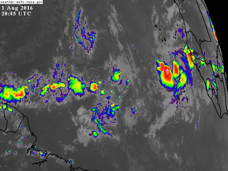
Re: Wave in East Atlantic
This wave is coming into view on far-right-hand side of Atlantic wide view. Note ULL with all of the shear that goes along with it is moving northward out of the MDR and upper-levels appear to be moistening now across the MDR (less orange in the WV loop) as one would expect as we start to move through August:

0 likes
-
alienstorm
- Category 1
- Posts: 496
- Joined: Tue Jul 31, 2007 1:29 pm
- Location: Miami Fla western suburb
Re: Wave in East Atlantic
0 likes
Personal Forecast Disclaimer:The posts in this forum are NOT official forecast and should not be used as such. They are just the opinion of the poster and may or may not be backed by sound meteorological data. They are NOT endorsed by any professional institution or storm2k.org. For official information, please refer to the NHC and NWS products.
-
Socalhurcnegirl227
- Category 1
- Posts: 267
- Age: 37
- Joined: Mon Jun 06, 2016 6:39 pm
- Location: Santa Barbara, CA
Re: Wave in East Atlantic
wonder how long they will take to label this an invest? 
0 likes
"I'm a wandress, i'm a one night stand,
dont belong to no city, dont belong to no man
i'm the violence in the pouring rain,
I'm a hurricane"
dont belong to no city, dont belong to no man
i'm the violence in the pouring rain,
I'm a hurricane"


Re: Wave in East Atlantic
12z GFS develops this weakly in the Western Caribbean, sends it over the Yucatan and into Mexico:

0 likes
-
cycloneye

- Admin

- Posts: 149451
- Age: 69
- Joined: Thu Oct 10, 2002 10:54 am
- Location: San Juan, Puerto Rico
Re: Wave in East Atlantic
Almost same track as EARL.
0 likes
Visit the Caribbean-Central America Weather Thread where you can find at first post web cams,radars
and observations from Caribbean basin members Click Here
and observations from Caribbean basin members Click Here
-
Gustywind

- Category 5

- Posts: 12334
- Joined: Mon Sep 03, 2007 7:29 am
- Location: Baie-Mahault, GUADELOUPE
Re: Wave in East Atlantic
000
AXNT20 KNHC 021036
TWDAT
Tropical Weather Discussion
NWS National Hurricane Center Miami FL
805 AM EDT TUE AUG 02 2016
Tropical wave in the east Tropical Atlantic extends from 16N22W
to 06N23W moving west 15 kt over the past 24 hours. Wave
coincides with a 700 mb trough as depicted in the global models
and is embedded within a low-amplitude surge of moisture as seen
on the SSMI Total Precipitable Water Imagery. Scattered moderate
to strong convection is west of the wave axis from 07N-12N
between 26W-31W.
0 likes
-
TheStormExpert
-
znel52
Re: Wave in East Atlantic
gatorcane wrote:This wave is coming into view on far-right-hand side of Atlantic wide view. Note ULL with all of the shear that goes along with it is moving northward out of the MDR and upper-levels appear to be moistening now across the MDR (less orange in the WV loop) as one would expect as we start to move through August:
Looks like the ULL helped suck some of the dry air in the MDR up northward.
1 likes
Who is online
Users browsing this forum: Ulf and 134 guests