

Area of convection in SE Caribbean
Moderator: S2k Moderators
Forum rules

The posts in this forum are NOT official forecasts and should not be used as such. They are just the opinion of the poster and may or may not be backed by sound meteorological data. They are NOT endorsed by any professional institution or STORM2K. For official information, please refer to products from the National Hurricane Center and National Weather Service.
Area of convection in SE Caribbean
There's an area of convection in the Intertropical Convergence Zone (ITCZ), which has been drifting westerly over the last few days and is currently around 8N 37W. May be nothing but seems like it bears watching:
0 likes
-
Gustywind

- Category 5

- Posts: 12334
- Joined: Mon Sep 03, 2007 7:29 am
- Location: Baie-Mahault, GUADELOUPE
Re: Area of Persistent Convection in Eastern Atlantic
Good catch Abajan  . Interresting feature. Let's see if this thing could be something more organize during the next couple of days.
0 likes
-
Gustywind
- Category 5
- Posts: 12334
- Joined: Mon Sep 03, 2007 7:29 am
- Location: Baie-Mahault, GUADELOUPE
Re: Area of Persistent Convection in Eastern Atlantic
Here is maybe our next guest 
000
AXNT20 KNHC 061200
TWDAT
Tropical Weather Discussion
NWS National Hurricane Center Miami FL
805 AM EDT SAT AUG 06 2016
Tropical wave in the east Tropical Atlantic extends along 35W
from 5N-13N moving west 10-15 kt over the past 24 hours. Wave
coincides with a weak 700 mb trough as depicted in the global
models and is embedded within a low amplitude surge of moisture
as seen on the SSMI Total Precipitable Water imagery. Scattered
moderate to strong convection is from 6N-10N between 34W-37W.
0 likes
-
Gustywind
- Category 5
- Posts: 12334
- Joined: Mon Sep 03, 2007 7:29 am
- Location: Baie-Mahault, GUADELOUPE
Re: Area of Persistent Convection in Eastern Atlantic
000
AXNT20 KNHC 061741
TWDAT
Tropical Weather Discussion
NWS National Hurricane Center Miami FL
141 PM EDT SAT AUG 6 2016
A tropical wave is over the eastern tropical Atlantic with an axis
that extends from near 14N37W to 05N37W, moving westward at
around 15 to 20 kt over the past 24 hours. High moisture surrounds
this wave south of 10N. A tilted 700 mb trough is evident across
this region. Numerous moderate convection is from 05N to 10N
between 34W and 39W.
0 likes
-
gatorcane

- S2K Supporter

- Posts: 23708
- Age: 48
- Joined: Sun Mar 13, 2005 3:54 pm
- Location: Boca Raton, FL
Re: Area of Persistent Convection in Eastern Atlantic
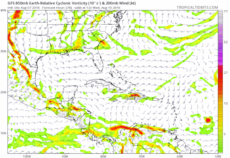
Latest EC shows much stronger low-level vorticity of this wave once in the Caribbean when compared to the 00z run
0 likes
-
gatorcane
- S2K Supporter
- Posts: 23708
- Age: 48
- Joined: Sun Mar 13, 2005 3:54 pm
- Location: Boca Raton, FL
Re: Tropical Wave along 35W
The 18Z GFS shows some possible development in the long-range as the wave approaches the Yucatan like what it was showing for Earl in the long-range
0 likes

Re: Tropical Wave along 35W
Yes and the 12z CMC is also showing a tight vorticity taking it North of the islands into Bahamas. Need to keep an eye on this one could sneak up on us.
0 likes
The following post is NOT an official forecast and should not be used as such. It is just the opinion of the poster and may or may not be backed by sound meteorological data. It is NOT endorsed by any professional institution including storm2k.org For Official Information please refer to the NHC and NWS products.
-
floridasun78
- Category 5
- Posts: 3755
- Joined: Sun May 17, 2009 10:16 pm
- Location: miami fl
Re: Tropical Wave along 35W
blp wrote:Yes and the 12z CMC is also showing a tight vorticity taking it North of the islands into Bahamas. Need to keep an eye on this one could sneak up on us.
wait other show it cmc not good tropical model
0 likes
Re: Tropical Wave along 35W
floridasun78 wrote:blp wrote:Yes and the 12z CMC is also showing a tight vorticity taking it North of the islands into Bahamas. Need to keep an eye on this one could sneak up on us.
wait other show it cmc not good tropical model
The CMC has improved IMO and it no longer develops everything and if not mistaken was one of the first on the idea of Earl going further south when the GFS and Euro where slaming it into Hispaniola so it has gained some of my respect lately.
1 likes
The following post is NOT an official forecast and should not be used as such. It is just the opinion of the poster and may or may not be backed by sound meteorological data. It is NOT endorsed by any professional institution including storm2k.org For Official Information please refer to the NHC and NWS products.
-
Hurricaneman

- Category 5
- Posts: 7404
- Age: 45
- Joined: Tue Aug 31, 2004 3:24 pm
- Location: central florida
Re: Tropical Wave along 35W
The 0zGFS at hr 114 seems to be showing a sharp wave with a good 850 vort with it, I do believe that the models are starting to come aboard with this wave and may need to be watched in the next week to 10 days because this could go 1 of 3 ways
1. Becomes a tropical storm or hurricane in the western Caribbean and follow a similar track to Earl
2. Becomes a tropical storm or hurricane in the western Caribbean and moves north to somewhere on the Gulf coast
3. Doesnt develop until the EPAC
so this does bear watching
The posts in this forum are NOT official forecast and should not be used as such. They are just the opinion of the poster and may or may not be backed by sound meteorological data. They are NOT endorsed by any professional institution or STORM2K. For official information, please refer to products from the National Hurricane Center and National Weather Service
0 likes
Re: Tropical Wave along 35W
Hurricaneman wrote:The 0zGFS at hr 114 seems to be showing a sharp wave with a good 850 vort with it, I do believe that the models are starting to come aboard with this wave and may need to be watched in the next week to 10 days because this could go 1 of 3 ways
1. Becomes a tropical storm or hurricane in the western Caribbean and follow a similar track to Earl
2. Becomes a tropical storm or hurricane in the western Caribbean and moves north to somewhere on the Gulf coast
3. Doesnt develop until the EPAC
so this does bear watching
The posts in this forum are NOT official forecast and should not be used as such. They are just the opinion of the poster and may or may not be backed by sound meteorological data. They are NOT endorsed by any professional institution or STORM2K. For official information, please refer to products from the National Hurricane Center and National Weather Service
Yes 00z GFS now onboard with this strong vorticity.
0 likes
The following post is NOT an official forecast and should not be used as such. It is just the opinion of the poster and may or may not be backed by sound meteorological data. It is NOT endorsed by any professional institution including storm2k.org For Official Information please refer to the NHC and NWS products.
-
Hurricaneman
- Category 5
- Posts: 7404
- Age: 45
- Joined: Tue Aug 31, 2004 3:24 pm
- Location: central florida
Re: Tropical Wave along 35W
Also reminds me of Earl development wise on most of the models
The posts in this forum are NOT official forecast and should not be used as such. They are just the opinion of the poster and may or may not be backed by sound meteorological data. They are NOT endorsed by any professional institution or STORM2K. For official information, please refer to products from the National Hurricane Center and National Weather Service
The posts in this forum are NOT official forecast and should not be used as such. They are just the opinion of the poster and may or may not be backed by sound meteorological data. They are NOT endorsed by any professional institution or STORM2K. For official information, please refer to products from the National Hurricane Center and National Weather Service
0 likes
-
Gustywind
- Category 5
- Posts: 12334
- Joined: Mon Sep 03, 2007 7:29 am
- Location: Baie-Mahault, GUADELOUPE
Re: Tropical Wave along 35W
000
AXNT20 KNHC 070542
TWDAT
Tropical Weather Discussion
NWS National Hurricane Center Miami FL
205 AM EDT SUN AUG 07 2016
Tropical wave in the central Tropical Atlantic extends along 41W
from 6N-14N moving west near 20 kt over the past 24 hours. Wave
coincides with a weak 700 mb trough as depicted in the global
models and is embedded within a low amplitude surge of moisture
as seen on the SSMI Total Precipitable Water imagery. Scattered
moderate convection is from 6N-8N between 41W-42W
0 likes

Re: Tropical Wave along 35W
06z GFS shows this tropical wave coming through the Windward & Leeward Islands as a strong tropical wave on Thursday. Fairly good vorticity with an UL anticyclone on top of it. Has it crashing into Hispaniola.
0 likes


Re: Tropical Wave along 35W
The overnight Euro dropped the the strong vorticity signature for this wave; looked as if the western half choked off the eastern half, preventing any sort of organization before being caught up in the trades.
Last edited by Siker on Sun Aug 07, 2016 10:02 am, edited 1 time in total.
0 likes

Re: Tropical Wave along 35W
You can see MLR in the wave. It has a nice rotation, but needs to climb a little to have a shot at anything.
The posts in this forum are NOT official forecast and should not be used as such. They are just the opinion of the poster and may or may not be backed by sound meteorological data. They are NOT endorsed by any professional institution or STORM2K. For official information, please refer to products from the National Hurricane Center and National Weather Service.
The posts in this forum are NOT official forecast and should not be used as such. They are just the opinion of the poster and may or may not be backed by sound meteorological data. They are NOT endorsed by any professional institution or STORM2K. For official information, please refer to products from the National Hurricane Center and National Weather Service.
0 likes

Re: Tropical Wave along 35W
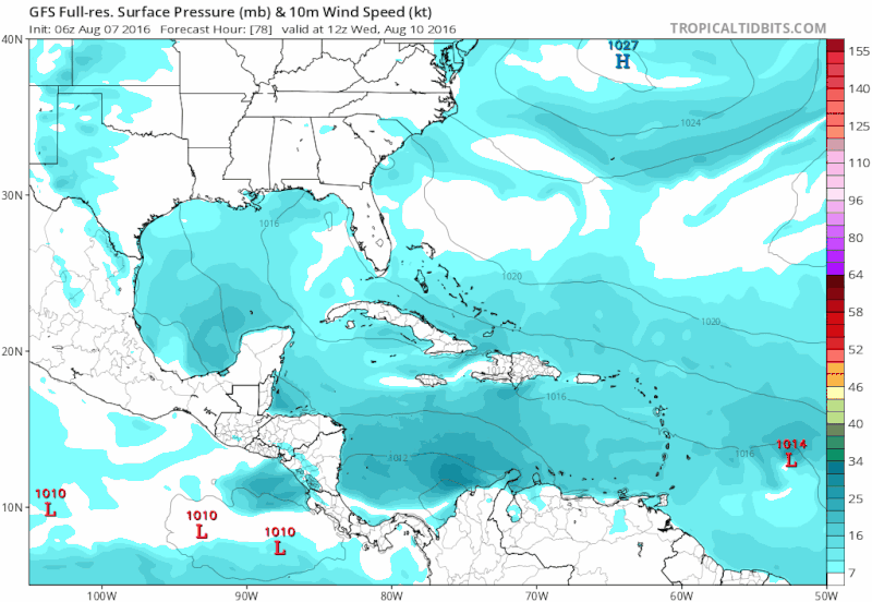
This could have a shot of development if it stays south of Hispaniola and Cuba, and enters the Gulf.
0 likes
Igor 2010, Sandy 2012, Fay 2014, Gonzalo 2014, Joaquin 2015, Nicole 2016, Humberto 2019, Imelda 2025
I am only a tropical weather enthusiast. My predictions are not official and may or may not be backed by sound meteorological data. For official information, please refer to the NHC and NWS products.
I am only a tropical weather enthusiast. My predictions are not official and may or may not be backed by sound meteorological data. For official information, please refer to the NHC and NWS products.
-
cycloneye

- Admin

- Posts: 149725
- Age: 69
- Joined: Thu Oct 10, 2002 10:54 am
- Location: San Juan, Puerto Rico
Re: Area of convection east of Trinidad & Tobago
abajan,made an update to the title of thread as the area you mentioned at the first place has raced west and now is East of Trinidad & Tobago.
0 likes
Visit the Caribbean-Central America Weather Thread where you can find at first post web cams,radars
and observations from Caribbean basin members Click Here
and observations from Caribbean basin members Click Here
Re: Area of convection east of Trinidad & Tobago
cycloneye wrote:abajan,made an update to the title of thread as the area you mentioned at the first place has raced west and now is East of Trinidad & Tobago.
Yeah, so I noticed. It's moved so fast that I'm not even sure it's the same area or if the first one dissipated and a new one formed.
0 likes
Re: Area of convection east of Trinidad & Tobago
12z Euro maintains an 850 reflection for this feature, eventually ending up over the Yucatan in 10 days.

0 likes
Who is online
Users browsing this forum: No registered users and 183 guests