
ATL: HERMINE - Models
Moderator: S2k Moderators
Re: ATL: INVEST 99L - Models
12z GFS shows a strengthening TS as it crosses the gulf stream.
0 likes
-
cycloneye

- Admin

- Posts: 149519
- Age: 69
- Joined: Thu Oct 10, 2002 10:54 am
- Location: San Juan, Puerto Rico
Re: ATL: INVEST 99L - Models
I fixed it.
1 likes
Visit the Caribbean-Central America Weather Thread where you can find at first post web cams,radars
and observations from Caribbean basin members Click Here
and observations from Caribbean basin members Click Here
-
tolakram
- Admin
- Posts: 20186
- Age: 62
- Joined: Sun Aug 27, 2006 8:23 pm
- Location: Florence, KY (name is Mark)
Re: ATL: INVEST 99L - Models
This is GFS fantasy land so keep that in mind.

0 likes
M a r k
- - - - -
Join us in chat: Storm2K Chatroom Invite. Android and IOS apps also available.
The posts in this forum are NOT official forecasts and should not be used as such. Posts are NOT endorsed by any professional institution or STORM2K.org. For official information and forecasts, please refer to NHC and NWS products.


-
PTrackerLA

- Category 5

- Posts: 5281
- Age: 42
- Joined: Thu Oct 10, 2002 8:40 pm
- Location: Lafayette, LA
Re: ATL: INVEST 99L - Models
I wonder if the GFS is overdoing the intensity of 90L which lowers heights too much over the Mid-Atlantic. It's back to showing sub 910mb numbers for a storm in the long range and we all know how that has changed for 99L  .
.
0 likes
-
TheStormExpert
Re: ATL: INVEST 99L - Models
Strong TS/Weak Hurricane @ 240hrs. just East of Florida.

Last edited by TheStormExpert on Sun Aug 21, 2016 11:47 am, edited 1 time in total.
0 likes
-
xcool22
Re: ATL: INVEST 99L - Models
GFS Not Make Sense but okay
The posts in this forum are NOT official forecast and should not be used as such. They are just the opinion of the poster and may or may not be backed by sound meteorological data. They are NOT endorsed by any professional institution or STORM2K. For official information, please refer to products from the National Hurricane Center and National Weather Service.
The posts in this forum are NOT official forecast and should not be used as such. They are just the opinion of the poster and may or may not be backed by sound meteorological data. They are NOT endorsed by any professional institution or STORM2K. For official information, please refer to products from the National Hurricane Center and National Weather Service.
0 likes
-
Blown Away

- S2K Supporter

- Posts: 10253
- Joined: Wed May 26, 2004 6:17 am
Re: ATL: INVEST 99L - Models
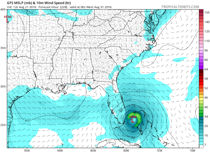
12z @240... Cat 1 Hurricane stalled @30 miles E of WPB and then starts ENE movement... 90L is a beast... Crazy run...
0 likes
Hurricane Eye Experience: David 79, Irene 99, Frances 04, Jeanne 04, Wilma 05… Hurricane Brush Experience: Andrew 92, Erin 95, Floyd 99, Matthew 16, Irma 17, Ian 22, Nicole 22…
Re: ATL: INVEST 99L - Models
What I get out of the last couple of days of more reliable model runs overall is that especially S and C FL will need to be on guard for potential impact from 99L near the end of August, whether it be low or higher impact.
Last edited by LarryWx on Sun Aug 21, 2016 12:00 pm, edited 1 time in total.
2 likes
Personal Forecast Disclaimer:
The posts in this forum are NOT official forecasts and should not be used as such. They are just the opinion of the poster and may or may not be backed by sound meteorological data. They are NOT endorsed by any professional institution or storm2k.org. For official information, please refer to the NHC and NWS products.
The posts in this forum are NOT official forecasts and should not be used as such. They are just the opinion of the poster and may or may not be backed by sound meteorological data. They are NOT endorsed by any professional institution or storm2k.org. For official information, please refer to the NHC and NWS products.

-
tolakram
- Admin
- Posts: 20186
- Age: 62
- Joined: Sun Aug 27, 2006 8:23 pm
- Location: Florence, KY (name is Mark)
Re: ATL: INVEST 99L - Models
In my opinion ...
The thing to keep in mind here for the longer range is that errors in genesis prediction make or break an entire run. If the GFS incorrectly develops the storm early then who knows where the wave ends up if it doesn't develop. If the Euro misses development then a similar kind of error where a feature ends up in a completely different place than where it would be if it developed.
The thing to keep in mind here for the longer range is that errors in genesis prediction make or break an entire run. If the GFS incorrectly develops the storm early then who knows where the wave ends up if it doesn't develop. If the Euro misses development then a similar kind of error where a feature ends up in a completely different place than where it would be if it developed.
0 likes
M a r k
- - - - -
Join us in chat: Storm2K Chatroom Invite. Android and IOS apps also available.
The posts in this forum are NOT official forecasts and should not be used as such. Posts are NOT endorsed by any professional institution or STORM2K.org. For official information and forecasts, please refer to NHC and NWS products.
- - - - -
Join us in chat: Storm2K Chatroom Invite. Android and IOS apps also available.
The posts in this forum are NOT official forecasts and should not be used as such. Posts are NOT endorsed by any professional institution or STORM2K.org. For official information and forecasts, please refer to NHC and NWS products.
-
Bocadude85

- Category 5
- Posts: 2991
- Age: 39
- Joined: Mon Apr 18, 2005 2:20 pm
- Location: Honolulu,Hi
Re: ATL: INVEST 99L - Models
Blown Away wrote:12z @240... Cat 1 Hurricane stalled @30 miles E of WPB and then starts ENE movement... 90L is a beast... Crazy run...
GFS has been very insistent on moving whatever this may become into the northwest Bahamas. Would not have taken much to bring this ashore in SE Florida on this run. Models are going to keep windshield wiping until the time frame gets a little closer.
0 likes


Re: ATL: INVEST 99L - Models
NDG wrote:And of course I can't forget about the crazy CMC:
Thank God It's the CMC!

0 likes
-
gatorcane

- S2K Supporter
- Posts: 23708
- Age: 48
- Joined: Sun Mar 13, 2005 3:54 pm
- Location: Boca Raton, FL
Re: ATL: INVEST 99L - Models
Takeaway from these models in long-range is development in or near Bahamas is quite possible. Where it would go, who would be impacted, or how strong it would get is too early to know. Situation still reminds me a lot of how models handled Earl in long-range and as we kept getting closer to that event.
0 likes
Re: ATL: INVEST 99L - Models
Though I think development near the Bahamas is a good possibility I would like to see the operational Euro come on board, because in the short term it has been the only model that was right showing no development before the Leeward Islands.
0 likes
-
Bocadude85
- Category 5
- Posts: 2991
- Age: 39
- Joined: Mon Apr 18, 2005 2:20 pm
- Location: Honolulu,Hi
Re: ATL: INVEST 99L - Models
gatorcane wrote:Takeaway from these models in long-range is development in or near Bahamas is quite possible. Where it would go, who would be impacted, or how strong it would get is too early to know. Situation still reminds me a lot of how models handled Earl in long-range and as we kept getting closer to that event.
I agree. This is very reminiscent of the way the models handled Earl before locking in on the final outcome.
0 likes
-
gatorcane
- S2K Supporter
- Posts: 23708
- Age: 48
- Joined: Sun Mar 13, 2005 3:54 pm
- Location: Boca Raton, FL
Re: ATL: INVEST 99L - Models
and the 12Z NAVGEM is back to showing development starting around the SE Bahamas area. The Euro is now the only model that is not showing development looking at the 12Z guidance. Of course the Euro is up next for its 12Z run so let's see what it does. I looked at the UKMET, GFS, CMC, and NAVGEM models..
Last edited by gatorcane on Sun Aug 21, 2016 12:21 pm, edited 1 time in total.
0 likes
-
gatorcane
- S2K Supporter
- Posts: 23708
- Age: 48
- Joined: Sun Mar 13, 2005 3:54 pm
- Location: Boca Raton, FL
Re: ATL: INVEST 99L - Models
12Z UKMET 144 hours looks to turn it north near the SE Bahamas with a decrease in forward speed:

0 likes
-
gatorcane
- S2K Supporter
- Posts: 23708
- Age: 48
- Joined: Sun Mar 13, 2005 3:54 pm
- Location: Boca Raton, FL
Re: ATL: INVEST 99L - Models
12Z NAVGEM has a strengthening system and it turning west in the Bahamas around 168. Heading slowly west at hour 180 where the run ends below:

0 likes
Who is online
Users browsing this forum: No registered users and 22 guests