https://twitter.com/EricBlake12/status/768431943650344960
ATL: HERMINE - Post-Tropical - Discussion
Moderator: S2k Moderators
-
cycloneye

- Admin

- Posts: 149550
- Age: 69
- Joined: Thu Oct 10, 2002 10:54 am
- Location: San Juan, Puerto Rico
Re: ATL: INVEST 99L - Discussion
0 likes
Visit the Caribbean-Central America Weather Thread where you can find at first post web cams,radars
and observations from Caribbean basin members Click Here
and observations from Caribbean basin members Click Here
Re: ATL: INVEST 99L - Discussion
Question: How significantly can land interaction change the center location or cause center reformation and
what effects if any could that have on the eventual track?
what effects if any could that have on the eventual track?
0 likes

Re: ATL: INVEST 99L - Discussion
StormHunter72 wrote:Pro mets don't agree.Aric Dunn wrote:its been a TC since around 11pm last night est. was very evident. now we are going to have land interaction and the center is likely to jump around today...
Aric is one of the top "layman" forecasters. I didn't even pass physics 101, and he's a doctor of it. Though we don't agree 100% of the time, he usually knows what he's talking about.
Looking to blow out this morning to the store to get some general provisions. We are out of bottled water, beer and red bulls, and we need some nonperishables. If I can knock that out today, I can sit back and crack out to S2K for a few days only having to gas up a couple of cars maybe Saturday morning in case things hit the fan next week.
4 likes
-
stormlover2013
Re: ATL: INVEST 99L - Discussion
it could change it no doubt,but the strong ridge is the player here, that ridge has been there all summer and looks right now its going to hold strong
0 likes
-
SFLcane

- S2K Supporter

- Posts: 10281
- Age: 48
- Joined: Sat Jun 05, 2010 1:44 pm
- Location: Lake Worth Florida
Re: ATL: INVEST 99L - Discussion
No sherdder as suggested by Blake could be very problematic.
1 likes

Re: ATL: INVEST 99L - Discussion
HR vis satellite loop continues to show that the circulation is closed & better defined than yesterday, but maybe elongated E to W.
0 likes
-
northjaxpro

- S2K Supporter
- Posts: 8900
- Joined: Mon Sep 27, 2010 11:21 am
- Location: Jacksonville, FL
Re: ATL: INVEST 99L - Discussion
Nederlander wrote:northjaxpro wrote:
Where is the source of such strong shear? Is there a developing upper.level low in the vicinity?
I believe there is an east/west trough to the north.. someone correct me if I am wrong..
Yes, there is a trough up there north of the Bahamas. This trough should induce northwest motion at least for the next 72 hours or so. 99L could get as far as the NW Bahamas, before the ridge really turns 99L westward or west-southwest across the Florida after that.
Last edited by northjaxpro on Wed Aug 24, 2016 8:13 am, edited 1 time in total.
0 likes
NEVER, EVER SAY NEVER in the tropics and weather in general, and most importantly, with life itself!!
________________________________________________________________________________________
Fay 2008 Beryl 2012 Debby 2012 Colin 2016 Hermine 2016 Julia 2016 Matthew 2016 Irma 2017 Dorian 2019
________________________________________________________________________________________
Fay 2008 Beryl 2012 Debby 2012 Colin 2016 Hermine 2016 Julia 2016 Matthew 2016 Irma 2017 Dorian 2019
Re: ATL: INVEST 99L - Discussion
BucMan2 wrote:Question: How significantly can land interaction change the center location or cause center reformation and
what effects if any could that have on the eventual track?
It depends. Sometimes it can help intensify (e.g. A perpendicularly landfalling storm in Texas). Other times it can rip a system apart ala mountains of Hispaniola or Mexico. A lot of times through the smaller islands, centers will want to stay over water and will hug or spin just off a coastline often going around even little jut outs. We are going to have to wait a few days to see what happens as it moves between where it is now and the Bahamas. To your question, there's no easy answer. Land interaction could do little, could influence the track some.
0 likes
-
StormHunter72
- Tropical Storm

- Posts: 166
- Joined: Wed May 25, 2016 6:36 am
- Location: Nature Coast
Re: ATL: INVEST 99L - Discussion
Oh cool. I am impressedSteve wrote:StormHunter72 wrote:Pro mets don't agree.Aric Dunn wrote:its been a TC since around 11pm last night est. was very evident. now we are going to have land interaction and the center is likely to jump around today...
Aric is one of the top "layman" forecasters. I didn't even pass physics 101, and he's a doctor of it. Though we don't agree 100% of the time, he usually knows what he's talking about.
Looking to blow out this morning to the store to get some general provisions. We are out of bottled water, beer and red bulls, and we need some nonperishables. If I can knock that out today, I can sit back and crack out to S2K for a few days only having to gas up a couple of cars maybe Saturday morning in case things hit the fan next week.
2 likes
The following post is NOT an official forecast and should not be used as such. It is just the opinion of the poster and may or may not be backed by sound meteorological data. It is NOT endorsed by any professional institution including storm2k.org For Official Information please refer to the NHC and NWS products.
-
Tireman4

- S2K Supporter
- Posts: 5903
- Age: 60
- Joined: Fri Jun 30, 2006 1:08 pm
- Location: Humble, Texas
- Contact:
Re: ATL: INVEST 99L - Discussion
Steve wrote:StormHunter72 wrote:Pro mets don't agree.Aric Dunn wrote:its been a TC since around 11pm last night est. was very evident. now we are going to have land interaction and the center is likely to jump around today...
Aric is one of the top "layman" forecasters. I didn't even pass physics 101, and he's a doctor of it. Though we don't agree 100% of the time, he usually knows what he's talking about.
Looking to blow out this morning to the store to get some general provisions. We are out of bottled water, beer and red bulls, and we need some nonperishables. If I can knock that out today, I can sit back and crack out to S2K for a few days only having to gas up a couple of cars maybe Saturday morning in case things hit the fan next week.
I second that motion. I have been on this board for 10 years. Aric knows his stuff.
7 likes

Re: ATL: INVEST 99L - Discussion
I see what Matt Lanza is saying. It's currently not far enough north and away from Hispaniola to completely write off that possibility of it affecting its future track/intensity. Today will be a good one to watch if you're glued to your screen.
2 likes
Personal Forecast Disclaimer:
The posts in this forum are NOT official forecast and should not be used as such. They are just the opinion of the poster and may or may not be backed by sound meteorological data. They are NOT endorsed by any professional institution or storm2k.org. For official information, please refer to the NHC and NWS products.
The posts in this forum are NOT official forecast and should not be used as such. They are just the opinion of the poster and may or may not be backed by sound meteorological data. They are NOT endorsed by any professional institution or storm2k.org. For official information, please refer to the NHC and NWS products.
-
SFLcane
- S2K Supporter
- Posts: 10281
- Age: 48
- Joined: Sat Jun 05, 2010 1:44 pm
- Location: Lake Worth Florida
Re: ATL: INVEST 99L - Discussion
wxman57 wrote:SFLcane wrote:wxman57 wrote:The center may be on the north side of that convection, up around 17.7-17.8N.
57 still expecting a hurricane in SFL?
It sure could be a hurricane before S. Florida.
0 likes
Re: ATL: INVEST 99L - Discussion
This is where I see the LLC. IMO.
Moderate to strong shear to its north, it will have a tough time north of P.R. & Hispaniola until the shear subsides.
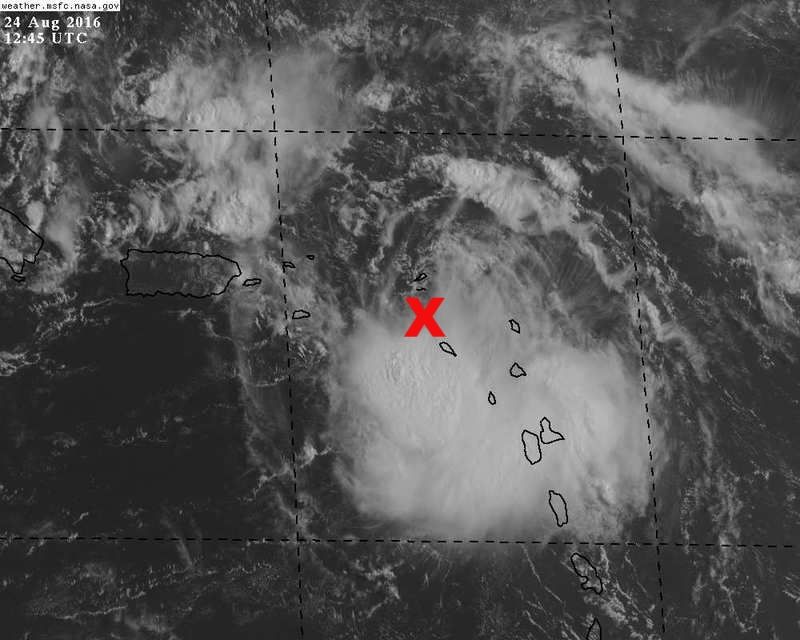
Moderate to strong shear to its north, it will have a tough time north of P.R. & Hispaniola until the shear subsides.
0 likes


Re: ATL: INVEST 99L - Discussion
At first glance, it might appear that Hispaniola is in the way (and it and PR are close) but as latest readings indicate, it is gaining latitude and (per NHC as source in the 8am outlook) has slowed down to 15mph.
Last edited by JaxGator on Wed Aug 24, 2016 8:20 am, edited 1 time in total.
0 likes
The posts or stuff said are NOT an official forecast. Please look to the NHC and NWS for official forecasts and products.
Floyd-1999, Frances-2004, Jeanne-2004, Fay-2008, Beryl-2012, Debby-2012, Colin-2016, Hermine-2016, Julia-2016, Matthew-2016, Irma-2017, Elsa-2021, Idalia-2023, Debby-2024, Helene-2024.
Go Gators! Go Jags!
Floyd-1999, Frances-2004, Jeanne-2004, Fay-2008, Beryl-2012, Debby-2012, Colin-2016, Hermine-2016, Julia-2016, Matthew-2016, Irma-2017, Elsa-2021, Idalia-2023, Debby-2024, Helene-2024.
Go Gators! Go Jags!
-
centuryv58

- Tropical Storm
- Posts: 233
- Age: 67
- Joined: Sat Jul 30, 2016 1:24 pm
- Location: Southeast Florida
Re: ATL: INVEST 99L - Discussion
SoupBone wrote:SFLcane wrote:https://twitter.com/ericblake12/status/768432310534410241
I see what Matt Lanza is saying. It's currently not far enough north and away from Hispaniola to completely write off that possibility of it affecting its future track/intensity. Today will be a good one to watch if you're glued to your screen.
I don't think the NHC guy Blake thinks that will be an issue though.
1 likes
-
Nederlander
- S2K Supporter
- Posts: 1259
- Joined: Sat Jul 19, 2008 4:28 pm
- Location: Conroe, TX
Re: ATL: INVEST 99L - Discussion
SoupBone wrote:
I see what Matt Lanza is saying. It's currently not far enough north and away from Hispaniola to completely write off that possibility of it affecting its future track/intensity. Today will be a good one to watch if you're glued to your screen.
It's going to have to track almost due west at this point for Hispaniola to be an issue imo.
1 likes
Re: ATL: INVEST 99L - Discussion
Are any models hinting at all about a slowdown? I know a few had it actually moving faster, but if it were to significantly slow down, are there any indications that the ridge could degrade allowing for a small window of opportunity to head north? I'm not suggesting out to sea at all, but a more northern run toward the panhandle or Jacksonville.
0 likes
Personal Forecast Disclaimer:
The posts in this forum are NOT official forecast and should not be used as such. They are just the opinion of the poster and may or may not be backed by sound meteorological data. They are NOT endorsed by any professional institution or storm2k.org. For official information, please refer to the NHC and NWS products.
The posts in this forum are NOT official forecast and should not be used as such. They are just the opinion of the poster and may or may not be backed by sound meteorological data. They are NOT endorsed by any professional institution or storm2k.org. For official information, please refer to the NHC and NWS products.
Re: ATL: INVEST 99L - Discussion
centuryv58 wrote:
I don't think the NHC guy Blake thinks that will be an issue though.
A battle of the mets for sure.
0 likes
Personal Forecast Disclaimer:
The posts in this forum are NOT official forecast and should not be used as such. They are just the opinion of the poster and may or may not be backed by sound meteorological data. They are NOT endorsed by any professional institution or storm2k.org. For official information, please refer to the NHC and NWS products.
The posts in this forum are NOT official forecast and should not be used as such. They are just the opinion of the poster and may or may not be backed by sound meteorological data. They are NOT endorsed by any professional institution or storm2k.org. For official information, please refer to the NHC and NWS products.
-
SouthFLTropics

- Category 5

- Posts: 4258
- Age: 50
- Joined: Thu Aug 14, 2003 8:04 am
- Location: Port St. Lucie, Florida
Re: ATL: INVEST 99L - Discussion
Steve wrote:BucMan2 wrote:Question: How significantly can land interaction change the center location or cause center reformation and
what effects if any could that have on the eventual track?
It depends. Sometimes it can help intensify (e.g. A perpendicularly landfalling storm in Texas). Other times it can rip a system apart ala mountains of Hispaniola or Mexico. A lot of times through the smaller islands, centers will want to stay over water and will hug or spin just off a coastline often going around even little jut outs. We are going to have to wait a few days to see what happens as it moves between where it is now and the Bahamas. To your question, there's no easy answer. Land interaction could do little, could influence the track some.
If you will recall, Ivan did exactly this dance around an island in 2004 when it went around Jamaica.
1 likes
Fourth Generation Florida Native
Personal Storm History: David 79, Andrew 92, Erin 95, Floyd 99, Irene 99, Frances 04, Jeanne 04, Wilma 05, Matthew 16, Irma 17, Ian 22, Nicole 22, Milton 24
Personal Storm History: David 79, Andrew 92, Erin 95, Floyd 99, Irene 99, Frances 04, Jeanne 04, Wilma 05, Matthew 16, Irma 17, Ian 22, Nicole 22, Milton 24
Who is online
Users browsing this forum: No registered users and 20 guests