

ATL: HERMINE - Post-Tropical - Discussion
Moderator: S2k Moderators
Re: ATL: INVEST 99L - Discussion
Shear seems to keep moving along with the system, but it's slightly weaker than it was yesterday evening.
0 likes
Personal Forecast Disclaimer:
The posts in this forum are NOT official forecast and should not be used as such. They are just the opinion of the poster and may or may not be backed by sound meteorological data. They are NOT endorsed by any professional institution or storm2k.org. For official information, please refer to the NHC and NWS products.
The posts in this forum are NOT official forecast and should not be used as such. They are just the opinion of the poster and may or may not be backed by sound meteorological data. They are NOT endorsed by any professional institution or storm2k.org. For official information, please refer to the NHC and NWS products.
Re: ATL: INVEST 99L - Discussion
wxman57 wrote:No development today or tomorrow, most likely. Wait for Tuesday afternoon. Recon will confirm a TD then. Watch out northern FL Peninsula on Thursday. Could be a hurricane landfall north of Tampa.
Yikes. I hope I didn't curse myself. I've got about a dozen trees within reach of my condo. Kinda tempers my enthusiasm for wind. The nature coast/big bend area has a significant hurricane history. the fact that they've been off the hook for awhile means many think they're exempt. not even close to true. the state 24 hour rainfall record at Yankeetown from 1950 still stands today...was from hurricane Easy, which delivered winds over 100mph to cedar key for 9 1/2 hours. that region has a fascinating and ferocious hurricane history. it's on a luck streak no different from tampa bay. I'll keep a wary eye on 99L until it is gone.
1 likes
-
tolakram
- Admin

- Posts: 20186
- Age: 62
- Joined: Sun Aug 27, 2006 8:23 pm
- Location: Florence, KY (name is Mark)
Re: ATL: INVEST 99L - Discussion
saved gif

0 likes
M a r k
- - - - -
Join us in chat: Storm2K Chatroom Invite. Android and IOS apps also available.
The posts in this forum are NOT official forecasts and should not be used as such. Posts are NOT endorsed by any professional institution or STORM2K.org. For official information and forecasts, please refer to NHC and NWS products.
-
Aric Dunn
- Category 5

- Posts: 21238
- Age: 43
- Joined: Sun Sep 19, 2004 9:58 pm
- Location: Ready for the Chase.
- Contact:
Re: ATL: INVEST 99L - Discussion
We wont be waiting much longer.
1 likes
Note: If I make a post that is brief. Please refer back to previous posts for the analysis or reasoning. I do not re-write/qoute what my initial post said each time.
If there is nothing before... then just ask
Space & Atmospheric Physicist, Embry-Riddle Aeronautical University,
I believe the sky is falling...
If there is nothing before... then just ask
Space & Atmospheric Physicist, Embry-Riddle Aeronautical University,
I believe the sky is falling...
Re: ATL: INVEST 99L - Discussion
Recon should be out there at a good time to see if there's anything to this.
0 likes
-
AutoPenalti
- Category 5
- Posts: 4091
- Age: 29
- Joined: Mon Aug 17, 2015 4:16 pm
- Location: Ft. Lauderdale, Florida
Re: ATL: INVEST 99L - Discussion
I'm calling no TD today. Still looks pretty disorganized.
0 likes
The posts in this forum are NOT official forecasts and should not be used as such. They are just the opinion of the poster and may or may not be backed by sound meteorological data. They are NOT endorsed by any professional institution or STORM2K. For official information, please refer to products from the NHC and NWS.
Model Runs Cheat Sheet:
GFS (5:30 AM/PM, 11:30 AM/PM)
HWRF, GFDL, UKMET, NAVGEM (6:30-8:00 AM/PM, 12:30-2:00 AM/PM)
ECMWF (1:45 AM/PM)
TCVN is a weighted averaged

Re: ATL: INVEST 99L - Discussion
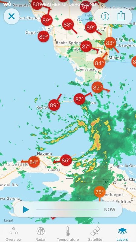
Center is beginning to fill in with cumulus and a small tower firing off just to the east.
Cloud tops are staying relatively cold for this time of day.
Cloud tops are staying relatively cold for this time of day.
0 likes
-
jlauderdal
- S2K Supporter

- Posts: 7240
- Joined: Wed May 19, 2004 5:46 am
- Location: NE Fort Lauderdale
- Contact:
-
Aric Dunn
- Category 5
- Posts: 21238
- Age: 43
- Joined: Sun Sep 19, 2004 9:58 pm
- Location: Ready for the Chase.
- Contact:
Re: ATL: INVEST 99L - Discussion
looks like the circ that developed yesterday in that deep convection has survived. its beginning to due small cyclonic to the wsw as Convection is increasing this morning.. of course shear is a problem if it stays as far south as possible it wont be as bad.
0 likes
Note: If I make a post that is brief. Please refer back to previous posts for the analysis or reasoning. I do not re-write/qoute what my initial post said each time.
If there is nothing before... then just ask
Space & Atmospheric Physicist, Embry-Riddle Aeronautical University,
I believe the sky is falling...
If there is nothing before... then just ask
Space & Atmospheric Physicist, Embry-Riddle Aeronautical University,
I believe the sky is falling...

Re: ATL: INVEST 99L - Discussion
Chances of the recon finding a TD this afternoon is getting higher. IMO.

0 likes
-
Dean4Storms
- S2K Supporter
- Posts: 6358
- Age: 63
- Joined: Sun Aug 31, 2003 1:01 pm
- Location: Miramar Bch. FL
Re: ATL: INVEST 99L - Discussion
psyclone wrote:wxman57 wrote:No development today or tomorrow, most likely. Wait for Tuesday afternoon. Recon will confirm a TD then. Watch out northern FL Peninsula on Thursday. Could be a hurricane landfall north of Tampa.
Yikes. I hope I didn't curse myself. I've got about a dozen trees within reach of my condo. Kinda tempers my enthusiasm for wind. The nature coast/big bend area has a significant hurricane history. the fact that they've been off the hook for awhile means many think they're exempt. not even close to true. the state 24 hour rainfall record at Yankeetown from 1950 still stands today...was from hurricane Easy, which delivered winds over 100mph to cedar key for 9 1/2 hours. that region has a fascinating and ferocious hurricane history. it's on a luck streak no different from tampa bay. I'll keep a wary eye on 99L until it is gone.
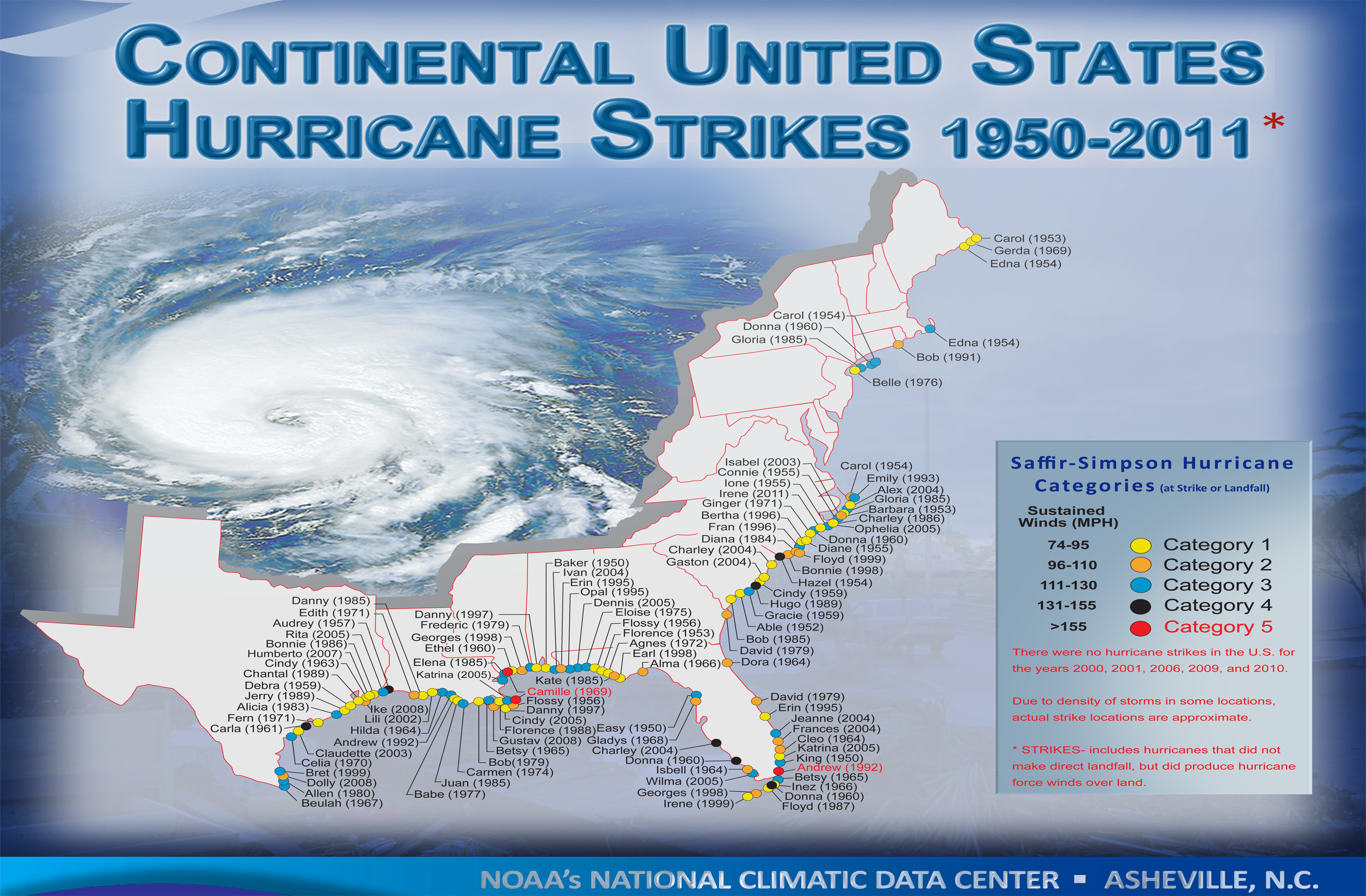
There is NOT a big hurricane history in the FL Big Bend area...
http://www.nhc.noaa.gov/climo/images/conus_hurrStrikes_1950-2011.png
0 likes
-
tolakram
- Admin
- Posts: 20186
- Age: 62
- Joined: Sun Aug 27, 2006 8:23 pm
- Location: Florence, KY (name is Mark)
Re: ATL: INVEST 99L - Discussion
Here's the link the the rapid scan again, big images, 150 frames.
http://www.ssec.wisc.edu/data/1min/index.php?action=view_animation&req_method=nframes_enddate&enddate=20160828&endtime=latest&nframes=150&band=1&res=1&aniwidth=1200&aniheight=1200
http://www.ssec.wisc.edu/data/1min/index.php?action=view_animation&req_method=nframes_enddate&enddate=20160828&endtime=latest&nframes=150&band=1&res=1&aniwidth=1200&aniheight=1200
0 likes
M a r k
- - - - -
Join us in chat: Storm2K Chatroom Invite. Android and IOS apps also available.
The posts in this forum are NOT official forecasts and should not be used as such. Posts are NOT endorsed by any professional institution or STORM2K.org. For official information and forecasts, please refer to NHC and NWS products.
- - - - -
Join us in chat: Storm2K Chatroom Invite. Android and IOS apps also available.
The posts in this forum are NOT official forecasts and should not be used as such. Posts are NOT endorsed by any professional institution or STORM2K.org. For official information and forecasts, please refer to NHC and NWS products.
Re: ATL: INVEST 99L - Discussion
Dean4Storms wrote:psyclone wrote:wxman57 wrote:No development today or tomorrow, most likely. Wait for Tuesday afternoon. Recon will confirm a TD then. Watch out northern FL Peninsula on Thursday. Could be a hurricane landfall north of Tampa.
Yikes. I hope I didn't curse myself. I've got about a dozen trees within reach of my condo. Kinda tempers my enthusiasm for wind. The nature coast/big bend area has a significant hurricane history. the fact that they've been off the hook for awhile means many think they're exempt. not even close to true. the state 24 hour rainfall record at Yankeetown from 1950 still stands today...was from hurricane Easy, which delivered winds over 100mph to cedar key for 9 1/2 hours. that region has a fascinating and ferocious hurricane history. it's on a luck streak no different from tampa bay. I'll keep a wary eye on 99L until it is gone.
There is NOT a big hurricane history in the FL Big Bend area...
http://www.nhc.noaa.gov/climo/images/conus_hurrStrikes_1950-2011.png
Yes there is. believe it or not time began before 1950. Three substantial hurricanes hit this region in a month in 1886.
2 likes
-
Dean4Storms
- S2K Supporter
- Posts: 6358
- Age: 63
- Joined: Sun Aug 31, 2003 1:01 pm
- Location: Miramar Bch. FL
Re: ATL: INVEST 99L - Discussion
Looks like the 500mb Vorticity is closing in on the 850 and surface vort. Give this till tomorrow and I think we have TS!
0 likes

Re: ATL: INVEST 99L - Discussion
I wouldn't mind waiting around till Tuesday for stable track and 72 hour landfall predictions.
The low level circulation is shallow and could take 48 hours to build back up.
One thing that concerns me is that the low level center isn't elongated so by Tuesday this system could be ready to bomb if the shear lets up.
The low level circulation is shallow and could take 48 hours to build back up.
One thing that concerns me is that the low level center isn't elongated so by Tuesday this system could be ready to bomb if the shear lets up.
0 likes
-
MississippiWx

- S2K Supporter
- Posts: 1720
- Joined: Sat Aug 14, 2010 1:44 pm
- Location: Hattiesburg, Mississippi
Re: ATL: INVEST 99L - Discussion
I've seen several people mention how this will not be classified today or even tomorrow. If there is one thing I've learned about this system it is that I should never rule out other possibilities even if the chances seem slim.
0 likes
This post is not an official forecast and should not be used as such. It is just the opinion of MississippiWx and may or may not be backed by sound meteorological data. It is not endorsed by any professional institution including storm2k.org. For Official Information please refer to the NHC and NWS products.
-
Dean4Storms
- S2K Supporter
- Posts: 6358
- Age: 63
- Joined: Sun Aug 31, 2003 1:01 pm
- Location: Miramar Bch. FL
Re: ATL: INVEST 99L - Discussion
psyclone wrote:Dean4Storms wrote:psyclone wrote:Yikes. I hope I didn't curse myself. I've got about a dozen trees within reach of my condo. Kinda tempers my enthusiasm for wind. The nature coast/big bend area has a significant hurricane history. the fact that they've been off the hook for awhile means many think they're exempt. not even close to true. the state 24 hour rainfall record at Yankeetown from 1950 still stands today...was from hurricane Easy, which delivered winds over 100mph to cedar key for 9 1/2 hours. that region has a fascinating and ferocious hurricane history. it's on a luck streak no different from tampa bay. I'll keep a wary eye on 99L until it is gone.
There is NOT a big hurricane history in the FL Big Bend area...
http://www.nhc.noaa.gov/climo/images/conus_hurrStrikes_1950-2011.png
Yes there is. believe it or not time began before 1950. Three substantial hurricanes hit this region in a month in 1886.
Weather patterns have changed significantly since the late 1800's, back then NE FL and SE GA also saw many Hurricanes, but going by the last 70 yrs or so under much better observation with satellites, Hurricane Hunters, Radar, etc.... the FL Big Bend has not seen nearly the Hurricane activity as the Panhandle nor most of the remaining Gulf Coast. There have been a number of Tropical Storms largely due to late or early storms that get swept eastward in advance of digging CONUS troughs which usually induce shear and keep them from becoming Hurricanes that have impacted the Big Bend area over the years.
1 likes
Re: ATL: INVEST 99L - Discussion
Things can change very fast in the heart of hurricane season. While this disturbance hasn't been able to do much so far, it also hasn't dissipated despite non stop bombardment from shear, dry air, land based disruption...there's a tenacity that cannot be ignored.
1 likes
-
Frank P
- S2K Supporter
- Posts: 2779
- Joined: Fri Aug 29, 2003 10:52 am
- Location: Biloxi Beach, Ms
- Contact:
Re: ATL: INVEST 99L - Discussion
Looking at the rapid scan sat loop and radar out of the keys sure looks like a TD is forming ......... best its looks for days, at least during the daylight hours..
0 likes

Re: ATL: INVEST 99L - Discussion
psyclone wrote:Things can change very fast in the heart of hurricane season. While this disturbance hasn't been able to do much so far, it also hasn't dissipated despite non stop bombardment from shear, dry air, land based disruption...there's a tenacity that cannot be ignored.
Yep, that more than anything leads me to believe that "something more" seems apt to come out of all this. Focus of potential risk definately seems a bit more targeted to an area roughtly between Tampa and New Orleans (though I'd likely guess Ceder Key to Tallahassee area)
1 likes
Andy D
(For official information, please refer to the NHC and NWS products.)
(For official information, please refer to the NHC and NWS products.)
Who is online
Users browsing this forum: No registered users and 50 guests