#5272 Postby JaxGator » Tue Aug 30, 2016 8:56 am
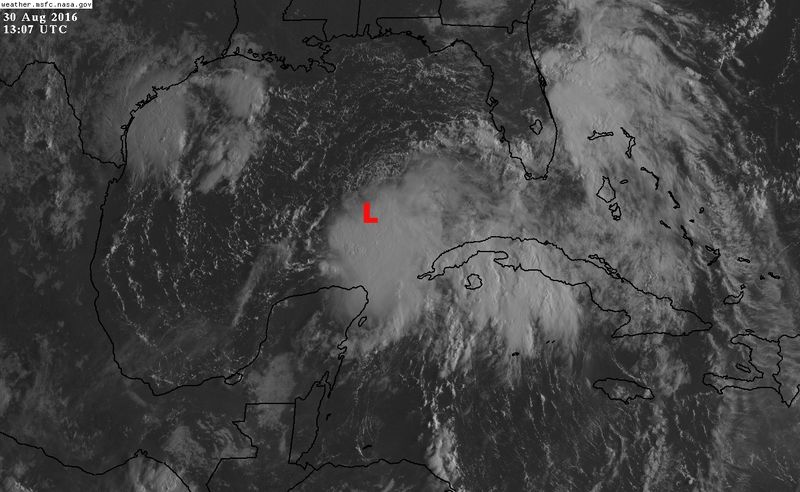
Evil Jeremy wrote:northjaxpro wrote:Good morning all!! The cyclone looks pretty good right now, as you.all have alluded to already, convection really expanding towards the northwest at this time. I have to think we likely will see upgrade ro TS by this afternoon, but I think it is already there to be honest.
Yeah it looks to be a Cedar Key to Jax runner on the ptojected track . Thursday will be the day likely here with the greatest effects from the cyclone. I will be keeping you all informed here, along with Jaxgator in this area of course during this event. I hope this will be like Colin was when it came through here, which was aa fast mover and aweak TS with no.really no severe impacts, except for heavy rain.
I'll also be chiming in from the Jax area. Should be interesting to see how this area reacts to a Tropical Storm, as compared to Broward County! Not that this should be a large threat to us, just some rain and wind (if it stays weak). Should be fun.
Yep, northjaxpro, it appears it'll take that track but hopefully it won't be too bad. Posters in Jax (Evil Jermey and tigerz3030 and I) will definitely help with updates and storm reports. It'll be interesting.
1 likes
The posts or stuff said are NOT an official forecast. Please look to the NHC and NWS for official forecasts and products.
Floyd-1999, Frances-2004, Jeanne-2004, Fay-2008, Beryl-2012, Debby-2012, Colin-2016, Hermine-2016, Julia-2016, Matthew-2016, Irma-2017, Elsa-2021, Idalia-2023, Debby-2024, Helene-2024.
Go Gators! Go Jags!