ATL: HERMINE - Post-Tropical - Discussion
Moderator: S2k Moderators

Re: ATL: NINE - Tropical Depression - Discussion
Due to the uncertainty of the short term movement the track will not be shifted as far west as the models have moved? Huh? Its already further west than there 2100 advisory
1 likes
-
SunnyThoughts
- Category 5

- Posts: 2263
- Joined: Wed Jul 09, 2003 12:42 pm
- Location: Pensacola, Florida
Re: ATL: NINE - Tropical Depression - Discussion
Yes this was very interesting part of the discussion from NHC
Unlike the previous several days, deep convection has finally
developed north of the low-level center during the past 6 hours,
and more recent satellite trends suggest that some inner-core
curved banding features may be developing. The upper-level outflow
has been improving and expanding in all quadrants now that the
vertical wind shear has decreased to less than 10 kt and has shifted
from a northerly to a westerly component
1 likes
-
SeGaBob
Re: ATL: NINE - Tropical Depression - Discussion
So the model consensus shifts farther west and NHC shifts east? Doesn't make much sense...
3 likes
Re: ATL: NINE - Tropical Depression - Discussion
SeGaBob wrote:So the model consensus shifts farther west and NHC shifts east? Doesn't make much sense...
But they did not shift the cone??
You can go to the graphics archive.
0 likes
The posts in this forum are NOT official forecast and should not be used as such. They are just the opinion of the poster and may or may not be backed by sound meteorological data. They are NOT endorsed by any professional institution or storm2k.org. For official information, please refer to the NHC and NWS products.
-
RazorTracks
- Tropical Wave

- Posts: 9
- Age: 38
- Joined: Sun Aug 28, 2016 4:59 pm
- Location: Arkansas
Re: ATL: NINE - Tropical Depression - Discussion
Just about to cover the entire GOM, at least with minimally moist air. I'm thinking that it may have grown too large with CoCs that are currently too weak to spin it up much, which would explain the lack of raising winds and TS upgrade.
First post by the way, even though I've been reading the boards for a long time now as a guest. I'm from Arkansas and have learned as much as I can absorb when it comes to tornadoes, so I thought I'd take an interest in tropical weather. I've stayed glued to this forum for about 8 days straight now
First post by the way, even though I've been reading the boards for a long time now as a guest. I'm from Arkansas and have learned as much as I can absorb when it comes to tornadoes, so I thought I'd take an interest in tropical weather. I've stayed glued to this forum for about 8 days straight now
Last edited by RazorTracks on Tue Aug 30, 2016 10:12 pm, edited 2 times in total.
4 likes
***NOT a professional, posts are opinion ONLY***
-
stormreader
Re: ATL: NINE - Tropical Depression - Discussion
SunnyThoughts wrote:PRESENT MOVEMENT...NNW OR 345 DEGREES AT 2 MPH...4 KM/H haha, why not just say stationary, how can you even measure something so large moving in any direction at 2 mph?
Yes. 2mph. It is a little funny, isn't it? Especially when you're talking about a not so organized system where it's difficult to really pinpoint a center. So there we have the long-awaited beginning of the north movement
0 likes
-
stormhunter7

- Category 2

- Posts: 763
- Joined: Mon May 26, 2008 3:13 pm
- Location: Panama City Beach, Florida
- Contact:
Re: ATL: NINE - Tropical Depression - Discussion
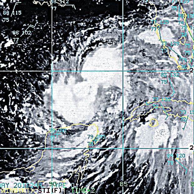
Even with the excellent discussion by Capt. Stewart, i think the center is cleary where that northern covnvection kicked back se and cleared out the air for the next deep convection that now is on going right over the center. That would be the little dot in the center.

See that ball in the middle... it exploded into some deep convection.
Tells me a few things... mid level winds have decreased into the system and now it may try to stack vertically for the next day or so, before trough winds kick in.?
See that ball in the middle... it exploded into some deep convection.
Tells me a few things... mid level winds have decreased into the system and now it may try to stack vertically for the next day or so, before trough winds kick in.?
0 likes
The following post is NOT an official forecast and should not be used as such. It is just the opinion of the poster and may or may not be backed by sound meteorological data. It is NOT endorsed by any professional institution including storm2k.org For Official Information please refer to the NHC and NWS products. http://www.nhc.noaa.gov
-
GeneratorPower

- S2K Supporter

- Posts: 1648
- Age: 46
- Joined: Sun Dec 18, 2005 11:48 pm
- Location: Huntsville, AL
Re: ATL: NINE - Tropical Depression - Discussion
Something is wrong here. In years past, storms were upgraded far more easily. This could have easily been called Hermine by this evening. There is always discretion on A) ending advisories for a dying system or B) initiating advisories or upgrading.
Why the sudden reluctance to upgrade storms? The umpires strike zone is pretty narrow here this month.
Why the sudden reluctance to upgrade storms? The umpires strike zone is pretty narrow here this month.
2 likes
-
SeGaBob
Re: ATL: NINE - Tropical Depression - Discussion
HurriGuy wrote:SeGaBob wrote:So the model consensus shifts farther west and NHC shifts east? Doesn't make much sense...
But they did not shift the cone??
You can go to the graphics archive.
Go to the interactive map and zoom in and compare. They actually went the opposite direction.
Last edited by SeGaBob on Tue Aug 30, 2016 10:13 pm, edited 1 time in total.
0 likes
-
OntarioEggplant
- Category 1

- Posts: 312
- Joined: Sun Aug 07, 2016 11:16 am
Re: ATL: NINE - Tropical Depression - Discussion
That could be a solid CDO intensifying tomorrow
0 likes
Re: ATL: NINE - Tropical Depression - Discussion
GeneratorPower wrote:Something is wrong here. In years past, storms were upgraded far more easily. This could have easily been called Hermine by this evening. There is always discretion on A) ending advisories for a dying system or B) initiating advisories or upgrading.
Why the sudden reluctance to upgrade storms? The umpires strike zone is pretty narrow here this month.
Yea the strike zone is the size of a Pringles can
1 likes
-
LJFire1467
- Tropical Low

- Posts: 14
- Age: 40
- Joined: Tue Aug 23, 2016 10:49 pm
- Location: Lake Jackson, Tx
Re: ATL: NINE - Tropical Depression - Discussion
Earlier, like 100 pages ago everyone was saying the stronger it gets the more west it will go. Is this not the case anymore? Im guessing the upper steering path has changed?
1 likes
-
drewschmaltz
- S2K Supporter
- Posts: 351
- Joined: Thu Aug 27, 2015 8:19 pm
Re: ATL: NINE - Tropical Depression - Discussion
mobilebay wrote:GeneratorPower wrote:Something is wrong here. In years past, storms were upgraded far more easily. This could have easily been called Hermine by this evening. There is always discretion on A) ending advisories for a dying system or B) initiating advisories or upgrading.
Why the sudden reluctance to upgrade storms? The umpires strike zone is pretty narrow here this month.
Yea the strike zone is the size of a Pringles can
It always seems like empirical data to me. I always get emotional and think "this has got to be a tropical storm" or similar. Then, the discussion comes out and it's like: it's not a storm because winds don't support it. You really can't argue empirical data... but I could be wrong.
1 likes
I HAVE ABSOLUTELY NO IDEA WHAT I'M TALKING ABOUT. PLEASE CONSULT SOMEONE WHO DOES. START WITH THE NHC. ALL POSTS ARE FOR ENTERTAINMENT PURPOSES ONLY.
-
toad strangler

- S2K Supporter
- Posts: 4546
- Joined: Sun Jul 28, 2013 3:09 pm
- Location: Earth
- Contact:
Re: ATL: NINE - Tropical Depression - Discussion
LJFire1467 wrote:Earlier, like 100 pages ago everyone was saying the stronger it gets the more west it will go. Is this not the case anymore? Im guessing the upper steering path has changed?
No, generally the stronger a tropical cyclone gets the more likely it is to move poleward into even a slight weakness.
Last edited by toad strangler on Tue Aug 30, 2016 10:21 pm, edited 1 time in total.
1 likes
My Weather Station
https://www.wunderground.com/dashboard/pws/KFLPORTS603
https://www.wunderground.com/dashboard/pws/KFLPORTS603
-
northjaxpro

- S2K Supporter
- Posts: 8900
- Joined: Mon Sep 27, 2010 11:21 am
- Location: Jacksonville, FL
Re: ATL: NINE - Tropical Depression - Discussion
]JaxGator wrote:For now, the NHC has increased the intensity forecast at landfall to 70 mph (right below hurricane strength). It looks great now. Definitely organizing.
Yeah it may reach Cat 1 status upon landfall. Going to be very interesting next 48 -60 hours here in Northeast Fl.and the North Florida region
0 likes
NEVER, EVER SAY NEVER in the tropics and weather in general, and most importantly, with life itself!!
________________________________________________________________________________________
Fay 2008 Beryl 2012 Debby 2012 Colin 2016 Hermine 2016 Julia 2016 Matthew 2016 Irma 2017 Dorian 2019
________________________________________________________________________________________
Fay 2008 Beryl 2012 Debby 2012 Colin 2016 Hermine 2016 Julia 2016 Matthew 2016 Irma 2017 Dorian 2019
-
GeneratorPower
- S2K Supporter
- Posts: 1648
- Age: 46
- Joined: Sun Dec 18, 2005 11:48 pm
- Location: Huntsville, AL
Re: ATL: NINE - Tropical Depression - Discussion
drewschmaltz wrote:mobilebay wrote:GeneratorPower wrote:Something is wrong here. In years past, storms were upgraded far more easily. This could have easily been called Hermine by this evening. There is always discretion on A) ending advisories for a dying system or B) initiating advisories or upgrading.
Why the sudden reluctance to upgrade storms? The umpires strike zone is pretty narrow here this month.
Yea the strike zone is the size of a Pringles can
It always seems like empirical data to me. I always get emotional and think "this has got to be a tropical storm" or similar. Then, the discussion comes out and it's like: it's not a storm because winds don't support it. You really can't argue empirical data... but I could be wrong.
Empirical data is important but look at previous seasons. The term "this may be generous" was used countless times as forecasters fudged up and down willy-nilly. This year is by. The. Book.
I have a theory. The NHC may be pushing back against the liberties taken by The Weather Channel and Accuweather type organizations hyping every darn thunderstorm. Notice how frustrated the on camera talent has been lately? Trying to hype a Category Zero hurricane? Or a 99L? NHC may be pushing back and withholding their cannon fodder.
2 likes
-
ScottNAtlanta

- Category 5
- Posts: 2535
- Joined: Sat May 25, 2013 3:11 pm
- Location: Atlanta, GA
Re: ATL: NINE - Tropical Depression - Discussion
If you look at the MIMIC Loop at the very end you will see the center consolidating
http://tropic.ssec.wisc.edu/real-time/m ... splay.html
http://tropic.ssec.wisc.edu/real-time/m ... splay.html
1 likes
The posts in this forum are NOT official forecast and should not be used as such. They are just the opinion of the poster and may or may not be backed by sound meteorological data. They are NOT endorsed by any professional institution or storm2k.org. For official information, please refer to the NHC and NWS products.
-
FLLurker32
- Tropical Storm

- Posts: 245
- Joined: Mon Aug 29, 2016 10:31 am
Re: ATL: NINE - Tropical Depression - Discussion
northjaxpro wrote:]JaxGator wrote:For now, the NHC has increased the intensity forecast at landfall to 70 mph (right below hurricane strength). It looks great now. Definitely organizing.
Yeah it may reach Cat 1 status upon landfall. Going to be very interesting next 48 -60 hours here in Northeast Fl.and the North Florida region
It's really strange. All of the counties along the I75 corridor within the cone have had tropical storm watches put in place as well as a hurricane statement. Can't say that I remember ever seeing both at the same time before. I live in Marion county, btw.
0 likes
Heather
-
SeGaBob
Re: ATL: NINE - Tropical Depression - Discussion
If the models continue their trend NHC will have to shift back west at some point. I still don't get why NHC would shift south and east...
Last edited by SeGaBob on Tue Aug 30, 2016 10:37 pm, edited 1 time in total.
0 likes

Re: ATL: NINE - Tropical Depression - Discussion
GeneratorPower wrote:drewschmaltz wrote:mobilebay wrote:Yea the strike zone is the size of a Pringles can
It always seems like empirical data to me. I always get emotional and think "this has got to be a tropical storm" or similar. Then, the discussion comes out and it's like: it's not a storm because winds don't support it. You really can't argue empirical data... but I could be wrong.
Empirical data is important but look at previous seasons. The term "this may be generous" was used countless times as forecasters fudged up and down willy-nilly. This year is by. The. Book.
I have a theory. The NHC may be pushing back against the liberties taken by The Weather Channel and Accuweather type organizations hyping every darn thunderstorm. Notice how frustrated the on camera talent has been lately? Trying to hype a Category Zero hurricane? Or a 99L? NHC may be pushing back and withholding their cannon fodder.
We've had more storms closer to land than the last few seasons overall--terms like "this may be generous" are more often used in the lack of actual surface data, for systems in the central Atlantic for instance. This year most of the storms have been fairly close to land, with the exceptions of Gaston and Fiona, so they don't have to guess based on satellite estimates--they know for certain what the winds at the surface are--and in the case of TD9, there is simply no surface data that supports upgrading to a tropical storm at the moment (and they rarely ever upgrade between recon flights unless there is some rapid development going on, or landfall is imminent.)
0 likes
The above post is not official and should not be used as such. It is the opinion of the poster and may or may not be backed by sound meteorological data. It is not endorsed by any professional institution or storm2k.org. For official information, please refer to the NHC and NWS products.
Who is online
Users browsing this forum: No registered users and 64 guests