ATL: HERMINE - Post-Tropical - Discussion

Moderator: S2k Moderators

Message
Author
User avatar
Yellow Evan
Professional-Met
Professional-Met
Posts: 16143
Age: 27
Joined: Fri Jul 15, 2011 12:48 pm
Location: Henderson, Nevada/Honolulu, HI
Contact:

Re: ATL: HERMINE - Hurricane - Discussion

#8461 Postby Yellow Evan » Thu Sep 01, 2016 6:18 pm

Image

T5.0ish
0 likes   

User avatar
Tampa Bay Hurricane
Category 5
Category 5
Posts: 5597
Age: 37
Joined: Fri Jul 22, 2005 7:54 pm
Location: St. Petersburg, FL

Re: ATL: HERMINE - Hurricane - Discussion

#8462 Postby Tampa Bay Hurricane » Thu Sep 01, 2016 6:19 pm

caneman wrote:At indian Shores we had a max wind gust of 78!! Sustained wind has really picked up now. We always get the worse wind when it gets north of us and from the s.e. quad.

That squall was incredible! We went from having not even TS warnings this AM to 78 mph gusts.
1 likes   

User avatar
JtSmarts
S2K Supporter
S2K Supporter
Posts: 1437
Age: 39
Joined: Thu Jul 10, 2003 1:29 pm
Location: Columbia, South Carolina

Re: ATL: HERMINE - Hurricane - Discussion

#8463 Postby JtSmarts » Thu Sep 01, 2016 6:19 pm

Amazing how the eye keeps looking better and better on IR.
1 likes   

User avatar
johngaltfla
Category 5
Category 5
Posts: 2069
Joined: Sun Jul 10, 2005 9:17 pm
Location: Sarasota County, FL
Contact:

Re: ATL: HERMINE - Hurricane - Discussion

#8464 Postby johngaltfla » Thu Sep 01, 2016 6:20 pm

If she had one more day at sea, all bets would be off on intensity
1 likes   

User avatar
ncbird
S2K Supporter
S2K Supporter
Posts: 424
Joined: Mon Sep 15, 2003 9:13 pm
Location: Jones County, NC

Re: ATL: HERMINE - Hurricane - Discussion

#8465 Postby ncbird » Thu Sep 01, 2016 6:21 pm

Jimsot wrote:
HurricaneBelle wrote:
TPAcane wrote:I think people tend to forget or have never experienced SUSTAINED high winds. That was a quick blast and it was kinda scary. For those near the eye of a hurricane it is surreal. You think how does a structure stand the pressure. Even a strong 60MPH sustained storm is frightening let alone a CAT 1. A lot of folks who have never experienced this and hopefully never will...they think these bands are a hurricane...never to experience the fright under a CDO. For those that say this is just a wimpy CAT 1...75-80mph or even 50mph sustained winds are very unnerving if not downright frightening. These bands always remind me of a big monster breathing, like a beast taunting, giving the storm almost a life force of its own...huffing and puffing. Always in awe....and again...prayers to those where this is headed....truly anything other than a strong winter cold front is not fun...


This is why it always aggravates me when, say, a tropical storm is brewing and someone says "oh we get a 40 MPH wind in a summer thunderstorm". Yeah, for about one minute or less with some gusts. Not hours of 40 MPH winds, which is a completely different thing.


With Hurricane Earl on Anguilla in 2010 we had 39 plus for about 36 hours with 75 plus for maybe 8 hours. It's not fun.


They are saying Hermine is heading my way and will still be a TS when it gets to us. I've learned my lesson first hand about the damage sustained TS winds can do. My generator is ready. Anything that can be sent flying is put up. Rest of prep will be done first thing in the morning. Over done maybe, but I have found the prep work allot easier than the cleanup work if you don't.
4 likes   

User avatar
chaser1
S2K Supporter
S2K Supporter
Posts: 5472
Age: 64
Joined: Sat Oct 15, 2005 5:59 pm
Location: Longwood, Fl

Re: ATL: HERMINE - Hurricane - Discussion

#8466 Postby chaser1 » Thu Sep 01, 2016 6:21 pm

Steve wrote:I think from a historical perspective, people are blowing the potential and look out of proportion. TWC was hawking the buoy the center just past by and promoted the gusts. Sustained was 50s which is plenty strong enough, but I'm thinking the NHC has been overplaying intensity for at least a few years. I haven't really seen a lot of sustained winds with any recent tropical systems measured on land. Obviously the winds will usually be stronger over water.

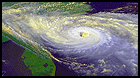
This is a cool storm but it's not some vicious Cat 3/4/5. Dry air slots have mixed in, there is no real core and the eye is ragged. It looks like a high end TS/low end H. I'm not downing on it, but people should keep their perspective.


Up to about 4 hours ago I would've fully agreed with you Steve. I have to admit though, with the tightening eye, colder tops, and convections tightly wound around the west side I can finally say that i'm fairly impressed with Hermine. I just got home and havn't had the luxury of keeping up here today but i'm curious as to what the highest gusts recorded by recon were (well, extrapolated of course). With the little time remaining yet with present appearance taken into account, I would frankly be surprised if the winds were not pushing 90mph by landfall.
3 likes   
Andy D

(For official information, please refer to the NHC and NWS products.)

ZX12R
S2K Supporter
S2K Supporter
Posts: 82
Joined: Mon Aug 29, 2016 8:09 pm

Re: ATL: HERMINE - Hurricane - Discussion

#8467 Postby ZX12R » Thu Sep 01, 2016 6:22 pm

Does that tiny eye suggest very strong destructive winds with it, but mostly localized to where it exactly comes ashore?
0 likes   

User avatar
tropicwatch
Category 5
Category 5
Posts: 3386
Age: 61
Joined: Sat Jun 02, 2007 10:01 am
Location: Panama City Florida
Contact:

Re: ATL: HERMINE - Hurricane - Discussion

#8468 Postby tropicwatch » Thu Sep 01, 2016 6:23 pm

ronjon wrote:Anybody got a nice detailed map of the panhandle coastline so we can tell where these locations are?


Well that little strip of land out in the gulf the northern eyewall is approaching is St. George Island.
0 likes   
Tropicwatch


Agnes 72', Eloise 75, Elena 85', Kate 85', Charley 86', Florence 88', Beryl 94', Dean 95', Erin 95', Opal 95', Earl 98', Georges 98', Ivan 2004', Arlene 2005', Dennis 2005', Ida 2009' Debby 2012' Irma 2017' Michael 2018'

User avatar
chaser1
S2K Supporter
S2K Supporter
Posts: 5472
Age: 64
Joined: Sat Oct 15, 2005 5:59 pm
Location: Longwood, Fl

Re: ATL: HERMINE - Hurricane - Discussion

#8469 Postby chaser1 » Thu Sep 01, 2016 6:23 pm

Tampa Bay Hurricane wrote:
caneman wrote:At indian Shores we had a max wind gust of 78!! Sustained wind has really picked up now. We always get the worse wind when it gets north of us and from the s.e. quad.

That squall was incredible! We went from having not even TS warnings this AM to 78 mph gusts.


Isnt that insane?? LOL You would think that some of those winds would've worked their way east a little, a bit earlier in the day
1 likes   
Andy D

(For official information, please refer to the NHC and NWS products.)

Nate-Gillson
Tropical Storm
Tropical Storm
Posts: 133
Age: 39
Joined: Sun Aug 22, 2004 8:27 pm
Location: Cedar Rapids, Iowa

Re: ATL: HERMINE - Hurricane - Discussion

#8470 Postby Nate-Gillson » Thu Sep 01, 2016 6:23 pm

johngaltfla wrote:If she had one more day at sea, all bets would be off on intensity


Yeah, possibly would have pulled a Wilma...
1 likes   

User avatar
JaxGator
Category 2
Category 2
Posts: 780
Joined: Sun Jun 12, 2016 3:33 pm
Location: Jacksonville Florida

Re: ATL: HERMINE - Hurricane - Discussion

#8471 Postby JaxGator » Thu Sep 01, 2016 6:24 pm

It's true it would be more than it is now with one more day, but it still over water now too and it looks stunning. Hurricanes that strengthen up to landfall are a bad mix.
1 likes   
The posts or stuff said are NOT an official forecast. Please look to the NHC and NWS for official forecasts and products.

Floyd-1999, Frances-2004, Jeanne-2004, Fay-2008, Beryl-2012, Debby-2012, Colin-2016, Hermine-2016, Julia-2016, Matthew-2016, Irma-2017, Elsa-2021, Idalia-2023, Debby-2024, Helene-2024.


Go Gators! Go Jags!

User avatar
TPAcane
S2K Supporter
S2K Supporter
Posts: 28
Joined: Fri Nov 18, 2005 4:48 pm
Location: TPA

Re: ATL: HERMINE - Hurricane - Discussion

#8472 Postby TPAcane » Thu Sep 01, 2016 6:25 pm

Is there a possibility this baroclinic enhancement to its NE may cause unexpected greater intensification? This was a fear as it got close to the coast...
0 likes   

JPmia
S2K Supporter
S2K Supporter
Posts: 1070
Joined: Thu Jun 03, 2004 11:01 pm
Location: Fort Lauderdale, FL

Re: ATL: HERMINE - Hurricane - Discussion

#8473 Postby JPmia » Thu Sep 01, 2016 6:25 pm

I can't find any live working streaming local Tallahassee news.. anyone have some links?
0 likes   

User avatar
chaser1
S2K Supporter
S2K Supporter
Posts: 5472
Age: 64
Joined: Sat Oct 15, 2005 5:59 pm
Location: Longwood, Fl

Re: ATL: HERMINE - Hurricane - Discussion

#8474 Postby chaser1 » Thu Sep 01, 2016 6:25 pm

ZX12R wrote:Does that tiny eye suggest very strong destructive winds with it, but mostly localized to where it exactly comes ashore?


Exactly! Strongest winds are located within the eye wall and most typically right at the point of landfall, but also to the right of center as well.
2 likes   
Andy D

(For official information, please refer to the NHC and NWS products.)

psyclone
S2K Supporter
S2K Supporter
Posts: 4762
Joined: Wed Aug 24, 2005 9:04 pm
Location: palm harbor fl

Re: ATL: HERMINE - Hurricane - Discussion

#8475 Postby psyclone » Thu Sep 01, 2016 6:26 pm

Our winds outside of squalls have increased markedly. the next band is going to put more people in the dark I'm afraid.
2 likes   

User avatar
JaxGator
Category 2
Category 2
Posts: 780
Joined: Sun Jun 12, 2016 3:33 pm
Location: Jacksonville Florida

Re: ATL: HERMINE - Hurricane - Discussion

#8476 Postby JaxGator » Thu Sep 01, 2016 6:27 pm

TPAcane wrote:Is there a possibility this baroclinic enhancement to its NE may cause unexpected greater intensification? This was a fear as it got close to the coast...


Ed Vallee ‏@EdValleeWx · 1m1 minute ago

As feared, southwesterly wind shear actually aiding in outflow, increasing ventilation and strengthening. #Hermine
1 likes   
The posts or stuff said are NOT an official forecast. Please look to the NHC and NWS for official forecasts and products.

Floyd-1999, Frances-2004, Jeanne-2004, Fay-2008, Beryl-2012, Debby-2012, Colin-2016, Hermine-2016, Julia-2016, Matthew-2016, Irma-2017, Elsa-2021, Idalia-2023, Debby-2024, Helene-2024.


Go Gators! Go Jags!

User avatar
JKingTampa
Tropical Storm
Tropical Storm
Posts: 101
Joined: Wed Sep 10, 2014 8:16 pm
Location: St. Petersburg, FL

Re: ATL: HERMINE - Hurricane - Discussion

#8477 Postby JKingTampa » Thu Sep 01, 2016 6:28 pm

psyclone wrote:Our winds outside of squalls have increased markedly. the next band is going to put more people in the dark I'm afraid.


Our winds here have increased very much over just the last 45 minutes or so. Right now I'm right next to I-275.
1 likes   

User avatar
NDG
S2K Supporter
S2K Supporter
Posts: 15446
Joined: Sun Jul 09, 2006 10:14 pm
Location: Orlando, FL

Re: ATL: HERMINE - Hurricane - Discussion

#8478 Postby NDG » Thu Sep 01, 2016 6:28 pm

JtSmarts wrote:
Frank P wrote:
panamatropicwatch wrote:Hermine's eye is looking impressive on enhanced satellite.

http://tropicwatch.info/hermineeye09012230.jpg


Eye appears to be tightening up on radar as well.. WOW... that is a great IR sat photo of a strengthening hurricane!


Compare that to the HWRF Simulated IR from 0z.

http://i64.tinypic.com/29mvek9.png


And people were laughing at the HWRF just a couple of days ago.
3 likes   

User avatar
ronjon
Category 5
Category 5
Posts: 4822
Joined: Fri Aug 19, 2005 5:17 pm
Location: Hernando Beach, FL

Re: ATL: HERMINE - Hurricane - Discussion

#8479 Postby ronjon » Thu Sep 01, 2016 6:28 pm

psyclone wrote:Our winds outside of squalls have increased markedly. the next band is going to put more people in the dark I'm afraid.


Watching that next band - looks stronger and longer lasting. Wxman57 said earlier he thought Hermine could top out at 100 mph at landfall.
2 likes   

User avatar
alan1961
Category 2
Category 2
Posts: 771
Joined: Mon Mar 20, 2006 11:58 am
Location: Derby, Derbyshire, England
Contact:

Re: ATL: HERMINE - Hurricane - Discussion

#8480 Postby alan1961 » Thu Sep 01, 2016 6:29 pm

Image

really tightened up, cat 2 before landfall?
3 likes   


Return to “2016”

Who is online

Users browsing this forum: No registered users and 3 guests