Texas Fall-2016

U.S. & Caribbean Weather Discussions and Severe Weather Events

Moderator: S2k Moderators

Forum rules

The posts in this forum are NOT official forecast and should not be used as such. They are just the opinion of the poster and may or may not be backed by sound meteorological data. They are NOT endorsed by any professional institution or STORM2K.

Help Support Storm2K
Message
Author
aggiecutter
Category 5
Category 5
Posts: 1753
Joined: Thu Oct 14, 2004 9:22 pm
Location: Texarkana

Re: Texas Fall-2016

#741 Postby aggiecutter » Thu Nov 17, 2016 5:56 pm

Brent wrote:FWD now has a freeze here Sunday Morning, and upper 20s just outside the metro.

Also the warmest high is 70 next Tuesday.


NWS forecast for Sunday morning in Texarkana is 30 degrees.
0 likes   

User avatar
TheProfessor
Professional-Met
Professional-Met
Posts: 3506
Age: 28
Joined: Tue Dec 03, 2013 10:56 am
Location: Wichita, Kansas

Re: Texas Fall-2016

#742 Postby TheProfessor » Thu Nov 17, 2016 6:30 pm

Bastardi's CFSv2 ensemble snow maps never fail to get a laugh. He posted one that ran at 6z this morning and all 4 of them had at least 8 inches of snow for Ohio over the next 45 days. But the best Ensemble had North Texas receiving 20+ inches of snow over the next 45 days. :lol:
0 likes   
An alumnus of The Ohio State University.

Your local National Weather Service office is your best source for weather information.

weatherdude1108
Category 5
Category 5
Posts: 4228
Joined: Tue Dec 13, 2011 1:04 pm
Location: Northwest Austin/Cedar Park, TX

Re: Texas Fall-2016

#743 Postby weatherdude1108 » Thu Nov 17, 2016 7:06 pm

TheProfessor wrote:Bastardi's CFSv2 ensemble snow maps never fail to get a laugh. He posted one that ran at 6z this morning and all 4 of them had at least 8 inches of snow for Ohio over the next 45 days. But the best Ensemble had North Texas receiving 20+ inches of snow over the next 45 days. :lol:

:uarrow:
It is theoretically possible for DFW to receive 20+ inches. More than our freezing drizzle. :wink:
0 likes   
The preceding post is NOT an official forecast, and should not be used as such. It is only the opinion of the poster and may or may not be backed by sound meteorological data. It is NOT endorsed by any professional institution including storm2k.org. For Official Information please refer to the NHC and NWS products.

Golf7070
Tropical Storm
Tropical Storm
Posts: 115
Joined: Sun Oct 30, 2016 8:58 pm

Re: Texas Fall-2016

#744 Postby Golf7070 » Thu Nov 17, 2016 7:10 pm

Dan Leonard
@DanLeonard_wx
51m
Best looking ECMWF weekly run of the season for the east, great mid Dec pattern. Finally the Pac jet takes a rest pic.twitter.com/NFKH3PbwlG

NTXW, do you believe the weeklies? I know they change alot. I'm not convinced the Pacific jet slows that much. It's on a pace I've never seen before with how strong it is.
0 likes   

User avatar
TheProfessor
Professional-Met
Professional-Met
Posts: 3506
Age: 28
Joined: Tue Dec 03, 2013 10:56 am
Location: Wichita, Kansas

Re: Texas Fall-2016

#745 Postby TheProfessor » Thu Nov 17, 2016 7:40 pm

weatherdude1108 wrote:
TheProfessor wrote:Bastardi's CFSv2 ensemble snow maps never fail to get a laugh. He posted one that ran at 6z this morning and all 4 of them had at least 8 inches of snow for Ohio over the next 45 days. But the best Ensemble had North Texas receiving 20+ inches of snow over the next 45 days. :lol:

:uarrow:
It is theoretically possible for DFW to receive 20+ inches. More than our freezing drizzle. :wink:


Oh it's possible, it's just insanely rare for everything to perfectly set up for it to occur. I would need to see the Skew-ts for the 2013 Ice Storm again, but that might be the closest some areas were for the chance of seeing 20 or so inches of snow. Of course without the warm nose there probably wouldn't have been as much overrunning moisture as there was.
0 likes   
An alumnus of The Ohio State University.

Your local National Weather Service office is your best source for weather information.

User avatar
Ntxw
Storm2k Moderator
Storm2k Moderator
Posts: 22785
Joined: Wed Oct 21, 2009 6:34 pm
Location: DFW, Texas

Re: Texas Fall-2016

#746 Postby Ntxw » Thu Nov 17, 2016 8:29 pm

Euro weeklies solidifies the great potential we may be about to embark in. I am as bold as ever that a wholesale hemisphere pattern change is currently underway. The storm that is sending the cold front now is actually a leading train of what could be a multitude of powerful systems that will kick out from the Pacific jet that is on the verge of getting blocked. The Pacific jet has been pounding North America but all signs point to a block that will slow everything down and forcing the jet underneath providing us with ample systems. Meanwhile the Aleutian ridge will attack it from behind, helping funnel some cold air from Asia. The AO will tank by the end of this month, potentially comparable levels as was in 2009 (Thank you snow advance). Good signals the stratosphere is undergoing a MMW with the collapse of the stratospheric PV (near record early). This upcoming pattern is 180 from last December. With a 500mb look complete opposite you would imagine we will not get a historically warm December again.

The Hudson block that is about to ensue will probably be the strongest we have seen since December of 2012.

Reminder we will be shifting to the winter thread on December 1st.

Image

Image

Image
0 likes   
The above post and any post by Ntxw is NOT an official forecast and should not be used as such. It is just the opinion of the poster and may or may not be backed by sound meteorological data. It is NOT endorsed by any professional institution including Storm2k. For official information, please refer to NWS products.

  Help support Storm2K!
Help Support Storm2K

User avatar
Ntxw
Storm2k Moderator
Storm2k Moderator
Posts: 22785
Joined: Wed Oct 21, 2009 6:34 pm
Location: DFW, Texas

Re: Texas Fall-2016

#747 Postby Ntxw » Thu Nov 17, 2016 9:18 pm

TheProfessor wrote:
weatherdude1108 wrote:
TheProfessor wrote:Bastardi's CFSv2 ensemble snow maps never fail to get a laugh. He posted one that ran at 6z this morning and all 4 of them had at least 8 inches of snow for Ohio over the next 45 days. But the best Ensemble had North Texas receiving 20+ inches of snow over the next 45 days. :lol:

:uarrow:
It is theoretically possible for DFW to receive 20+ inches. More than our freezing drizzle. :wink:


Oh it's possible, it's just insanely rare for everything to perfectly set up for it to occur. I would need to see the Skew-ts for the 2013 Ice Storm again, but that might be the closest some areas were for the chance of seeing 20 or so inches of snow. Of course without the warm nose there probably wouldn't have been as much overrunning moisture as there was.


I wonder if it's the storm the Euro weekly control sits and spins in Texas first week of December? If you cut your usual half to melting, tax another 5inches and you get a more reasonable 1-5" storm :D
0 likes   
The above post and any post by Ntxw is NOT an official forecast and should not be used as such. It is just the opinion of the poster and may or may not be backed by sound meteorological data. It is NOT endorsed by any professional institution including Storm2k. For official information, please refer to NWS products.


  Help support Storm2K!

Help Support Storm2K


Brent
S2K Supporter
S2K Supporter
Posts: 38089
Age: 36
Joined: Sun May 16, 2004 10:30 pm
Location: Tulsa Oklahoma
Contact:

Re: Texas Fall-2016

#748 Postby Brent » Thu Nov 17, 2016 9:40 pm

Ntxw wrote:Euro weeklies solidifies the great potential we may be about to embark in. I am as bold as ever that a wholesale hemisphere pattern change is currently underway. The storm that is sending the cold front now is actually a leading train of what could be a multitude of powerful systems that will kick out from the Pacific jet that is on the verge of getting blocked. The Pacific jet has been pounding North America but all signs point to a block that will slow everything down and forcing the jet underneath providing us with ample systems. Meanwhile the Aleutian ridge will attack it from behind, helping funnel some cold air from Asia. The AO will tank by the end of this month, potentially comparable levels as was in 2009 (Thank you snow advance). Good signals the stratosphere is undergoing a MMW with the collapse of the stratospheric PV (near record early). This upcoming pattern is 180 from last December. With a 500mb look complete opposite you would imagine we will not get a historically warm December again.

The Hudson block that is about to ensue will probably be the strongest we have seen since December of 2012.

Reminder we will be shifting to the winter thread on December 1st.


Oh I so hope you are right... the past year we've earned it lol.
0 likes   
#neversummer

User avatar
Ntxw
Storm2k Moderator
Storm2k Moderator
Posts: 22785
Joined: Wed Oct 21, 2009 6:34 pm
Location: DFW, Texas

Re: Texas Fall-2016

#749 Postby Ntxw » Thu Nov 17, 2016 9:46 pm

Brent wrote:Oh I so hope you are right... the past year we've earned it lol.


Oh I know, all this warmer than normal is getting really old fast. I just hope it pans out and we can lay some snow cover. Then send down the EPO mid December with the weak Nina and call it a winter. I'll be satisfied even if it warms up the rest of the way...we're actually still following 1983 fairly close at 500mb. Lets hope it comes through.

This is what the last week and a half of what 1983 was. I think we'll get a similar pattern, not that extreme of course. Kara/Barents ridge vanishes after dominating much of the month shifting to Greenland/Hudson

Image

Image
0 likes   
The above post and any post by Ntxw is NOT an official forecast and should not be used as such. It is just the opinion of the poster and may or may not be backed by sound meteorological data. It is NOT endorsed by any professional institution including Storm2k. For official information, please refer to NWS products.


  Help support Storm2K!

Help Support Storm2K


aggiecutter
Category 5
Category 5
Posts: 1753
Joined: Thu Oct 14, 2004 9:22 pm
Location: Texarkana

Re: Texas Fall-2016

#750 Postby aggiecutter » Thu Nov 17, 2016 10:28 pm

Ntxw wrote:Euro weeklies solidifies the great potential we may be about to embark in. I am as bold as ever that a wholesale hemisphere pattern change is currently underway. The storm that is sending the cold front now is actually a leading train of what could be a multitude of powerful systems that will kick out from the Pacific jet that is on the verge of getting blocked. The Pacific jet has been pounding North America but all signs point to a block that will slow everything down and forcing the jet underneath providing us with ample systems. Meanwhile the Aleutian ridge will attack it from behind, helping funnel some cold air from Asia. The AO will tank by the end of this month, potentially comparable levels as was in 2009 (Thank you snow advance). Good signals the stratosphere is undergoing a MMW with the collapse of the stratospheric PV (near record early). This upcoming pattern is 180 from last December. With a 500mb look complete opposite you would imagine we will not get a historically warm December again.

The Hudson block that is about to ensue will probably be the strongest we have seen since December of 2012.

Reminder we will be shifting to the winter thread on December 1st.

Image

Image

Image


If this doesn't come to fruition:

Image
0 likes   

Brent
S2K Supporter
S2K Supporter
Posts: 38089
Age: 36
Joined: Sun May 16, 2004 10:30 pm
Location: Tulsa Oklahoma
Contact:

Re: Texas Fall-2016

#751 Postby Brent » Fri Nov 18, 2016 12:40 am

GFS has 20s in DFW the first weekend of December(the very end of the run though). Mostly 60s for highs til then, maybe a couple days in the low 70s. A rain event looks to be on tap Thanksgiving weekend.
0 likes   
#neversummer

Ralph's Weather
S2K Supporter
S2K Supporter
Posts: 3269
Age: 38
Joined: Fri Dec 13, 2013 11:55 am
Location: Lindale, TX
Contact:

Re: Texas Fall-2016

#752 Postby Ralph's Weather » Fri Nov 18, 2016 7:28 am

Lots of lighting in the storms ahead of the front. Looks like E TX will see rain most of the morning. Front looks to be moving through Fort Worth now (Brownwood to FW to Sherman line). Looking at sites off to the NW it appears that the front brings a gradual fall in temps at a rate of about 4 degrees per hour with the sun coming up and no post frontal moisture I expect that to be slower east of I-35. So with temps in the upper 60s now I expect evening temps to be in the 55 to 60 range. Frost appears likely this weekend for most of the northern half of Texas with tomorrow morning the most likely west of I-35 and Sunday morning east of there. Some freezes possible especially north of I-30 and in could spots further south.
0 likes   
Follow on Facebook at Ralph's Weather.

weatherdude1108
Category 5
Category 5
Posts: 4228
Joined: Tue Dec 13, 2011 1:04 pm
Location: Northwest Austin/Cedar Park, TX

Re: Texas Fall-2016

#753 Postby weatherdude1108 » Fri Nov 18, 2016 7:40 am

I am guessing it will rain just enough with this front down here to scatter the dust on our vehicles into beige-colored dust drops. This is based on personal history. :roll:
But I am glad the 80s are done for now.
0 likes   
The preceding post is NOT an official forecast, and should not be used as such. It is only the opinion of the poster and may or may not be backed by sound meteorological data. It is NOT endorsed by any professional institution including storm2k.org. For Official Information please refer to the NHC and NWS products.

User avatar
Portastorm
Storm2k Moderator
Storm2k Moderator
Posts: 9914
Age: 63
Joined: Fri Jul 11, 2003 9:16 am
Location: Round Rock, TX
Contact:

Re: Texas Fall-2016

#754 Postby Portastorm » Fri Nov 18, 2016 8:18 am

weatherdude1108 wrote:I am guessing it will rain just enough with this front down here to scatter the dust on our vehicles into beige-colored dust drops. This is based on personal history. :roll:
But I am glad the 80s are done for now.


Based on the radar at 715 am, I'd say you've made an accurate forecast. :wink:
0 likes   
Any forecasts under my name are to be taken with a grain of salt. Get your best forecasts from the National Weather Service and National Hurricane Center.

User avatar
Ntxw
Storm2k Moderator
Storm2k Moderator
Posts: 22785
Joined: Wed Oct 21, 2009 6:34 pm
Location: DFW, Texas

Re: Texas Fall-2016

#755 Postby Ntxw » Fri Nov 18, 2016 9:22 am

It was around 70 this morning early when I left. Front has come through since 50s and blustery
0 likes   
The above post and any post by Ntxw is NOT an official forecast and should not be used as such. It is just the opinion of the poster and may or may not be backed by sound meteorological data. It is NOT endorsed by any professional institution including Storm2k. For official information, please refer to NWS products.


  Help support Storm2K!

Help Support Storm2K


User avatar
srainhoutx
S2K Supporter
S2K Supporter
Posts: 6919
Age: 67
Joined: Sun Jan 14, 2007 11:34 am
Location: Haywood County, NC
Contact:

Re: Texas Fall-2016

#756 Postby srainhoutx » Fri Nov 18, 2016 9:33 am

The morning Updated Super Ensemble Day 11+ analogs suggest the blocking regime may be a possibility. Stepping down... :wink:

Image
1 likes   
Carla/Alicia/Jerry(In The Eye)/Michelle/Charley/Ivan/Dennis/Katrina/Rita/Wilma/Ike/Harvey

Member: National Weather Association
Wx Infinity Forums
http://wxinfinity.com/index.php

Facebook.com/WeatherInfinity
Twitter @WeatherInfinity

Yukon Cornelius
S2K Supporter
S2K Supporter
Posts: 1798
Age: 41
Joined: Thu Dec 20, 2012 9:23 pm
Location: Dean, TX/Westcliffe, CO

Re: Texas Fall-2016

#757 Postby Yukon Cornelius » Fri Nov 18, 2016 9:55 am

Current temp of 45 with a wind chill of 37. Forecasted low of 29-30 tonight into tomorrow morning. Finally a freeze!
0 likes   
#neversummer

gpsnowman
S2K Supporter
S2K Supporter
Posts: 3185
Joined: Fri Jan 07, 2011 10:35 am
Location: Grand Prairie Tx

Re: Texas Fall-2016

#758 Postby gpsnowman » Fri Nov 18, 2016 10:13 am

DFW airport has a chance to have a low temperature in the 30's before an actual low in the 40's overnight. Weird. This front is about a month late.
0 likes   

User avatar
Tireman4
S2K Supporter
S2K Supporter
Posts: 5853
Age: 59
Joined: Fri Jun 30, 2006 1:08 pm
Location: Humble, Texas
Contact:

Re: Texas Fall-2016

#759 Postby Tireman4 » Fri Nov 18, 2016 10:45 am

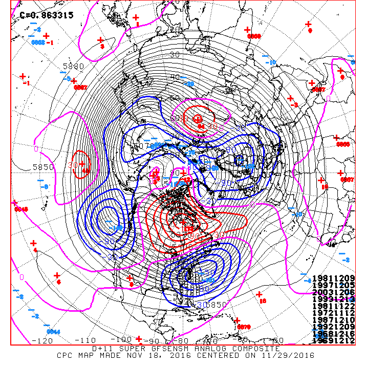
srainhoutx wrote:The morning Updated Super Ensemble Day 11+ analogs suggest the blocking regime may be a possibility. Stepping down... :wink:

Image


Finally, I have waited all year for the one met that does not use this term lightly...thank you..Come on Winter!!
0 likes   

User avatar
Tireman4
S2K Supporter
S2K Supporter
Posts: 5853
Age: 59
Joined: Fri Jun 30, 2006 1:08 pm
Location: Humble, Texas
Contact:

Re: Texas Fall-2016

#760 Postby Tireman4 » Fri Nov 18, 2016 10:53 am

000
FXUS64 KHGX 181200
AFDHGX

Area Forecast Discussion
National Weather Service Houston/Galveston TX
600 AM CST Fri Nov 18 2016

.AVIATION...
Scattered to broken clouds streaming up ahead of lowering central
Texas surface pressure associated with an approaching cold front.
Early day streamer showers to move across with rain better filling
in as the front...or the pre-frontal trough...enters southeastern
Texas later this morning. Scattered showers with embedded thunderstorms
will impact the terminals through the late afternoon hours. The
forecast timing of the cold frontal passage at CLL will be between
Noon and 2 PM...across the Houston terminals between 3 and 5 PM...and
through GLS between 6 and 8 PM. Moderate northerlies and clear skies
in this front`s wake early Saturday morning...strong offshore coastal
winds will persist through Saturday afternoon. 31

&&

.PREV DISCUSSION... /ISSUED 415 AM CST Fri Nov 18 2016/

DISCUSSION...
The cold front is still on track to move through Southeast Texas today
with showers and thunderstorms developing along and ahead of the boundary.
Look for the best chance of rain in the morning through early afternoon
hours across our northern counties when the front moves into the area,
then further southward in the afternoon through early evening hours
when the front moves through the area and off the coast. Overnight low
temperatures are unseasonably warm this morning (some 15 to 20 degrees
above normal) with readings in the mid 60s to near 70 inland and in
the mid 70s at the coast. Galveston`s record high temperature for the
day of 79 degrees (set in 1996) has a good chance of being broken. The
coolest temperatures of the day can be expected this evening as strong
surface high pressure begins building into the state from the north
and northwest. Breezy north winds will accompany the cool down this
evening and overnight, and wind advisories might be needed along the
coast and possibly some of our inland counties. Weekend temperatures
(coldest readings on Sunday morning) will have lows generally in the
30s and 40s (no freeze is anticipated) and highs in the 60s. Look for
a warm up early next week as the surface high moves off to the east
and winds come back around to the south and southeast. The area`s
next rain chances look to come around Tuesday/Wednesday with the
approach of the next cold front. The current forecast has a majority
of Southeast Texas on the cool and dry side for Thanksgiving. 42

MARINE...
Mariners should take the proper precautions today in advance of an
approaching cold front that...when it clears the coast tonight...will
generate advisory level to gale force wind and sea conditions in its
wake. This morning`s caution level winds/seas will gradually taper
off this afternoon as the waters fall just downstream of this cold
frontal boundary. Scattered showers with localized embedded
thunderstorms will likely ride in from the south through the day.
Early Saturday morning sustained winds and seas will near gale...with
frequent gusts to or above gale force over seas in excess of 9 feet
..and this may hoist short fuse Gale Warnings. At least caution
level conditions will persist through late Saturday...subsiding below
caution criteria Sunday morning. High pressure over the waters
early in the work week will provide light winds and seas Monday.
Return flow strengthens and shower/storm chances increase ahead of
the next western Texas front. The cold front is forecast to travel
off the coast sometime Wednesday. 31

&&

.PRELIMINARY POINT TEMPS/POPS...
College Station (CLL) 73 42 62 37 65 / 70 0 0 0 0
Houston (IAH) 80 46 64 40 65 / 70 10 0 0 0
Galveston (GLS) 80 53 63 51 64 / 60 40 0 0 0

&&

.HGX WATCHES/WARNINGS/ADVISORIES...
TX...NONE.
GM...Gale Watch from this evening through Saturday morning for the
following zones: Coastal waters from Freeport to the
Matagorda Ship Channel out 20 NM...Coastal waters from High
Island to Freeport out 20 NM...Galveston Bay...Matagorda
Bay...Waters from Freeport to the Matagorda Ship Channel
from 20 to 60 NM...Waters from High Island to Freeport from
20 to 60 NM.

SMALL CRAFT SHOULD EXERCISE CAUTION until noon CST today for the
following zones: Coastal waters from Freeport to the
Matagorda Ship Channel out 20 NM...Waters from Freeport to
the Matagorda Ship Channel from 20 to 60 NM...Waters from
High Island to Freeport from 20 to 60 NM.

SMALL CRAFT SHOULD EXERCISE CAUTION until 9 AM CST this morning
for the following zones: Coastal waters from High Island to
Freeport out 20 NM.

&&

$$

Discussion...42
Aviation/Marine...31
0 likes   


Return to “USA & Caribbean Weather”

Who is online

Users browsing this forum: No registered users and 13 guests