Texas Winter 2016-2017

Winter Weather Discussion

Moderator: S2k Moderators

Forum rules

The posts in this forum are NOT official forecast and should not be used as such. They are just the opinion of the poster and may or may not be backed by sound meteorological data. They are NOT endorsed by any professional institution or STORM2K.

Help Support Storm2K
Message
Author
orangeblood
S2K Supporter
S2K Supporter
Posts: 3714
Joined: Tue Dec 15, 2009 6:14 pm
Location: Fort Worth, TX

Re: Texas Winter 2016-2017

#161 Postby orangeblood » Wed Nov 30, 2016 1:03 pm

srainhoutx wrote:Some have been asking what the mid December toward Christmas timeframe may offer. The Updated CFSv2 Monthly climate model suggests colder than normal temperatures and slightly above normal precipitation chances. Typically I have noticed a bit of a warm bias for this particular Long Range Ensemble Model over the years. That said look how cold our source Regions of Eastern Alaska and NW Canada throughout the month.


There are some incredible negative anomalies showing up in Western Canada for December....I've been researching into WHY over the past few days and I think I've come up with a plausible reason. I believe a big driver is the persistent Bering Strait Ridge that continues to hit and hold for long periods of time. This is causing a massive downstream trough to form over western Canada over and over. What could be causing this ridge to hold ? One plausible explanation could be regarding the sea ice coverage in that part of the world at this time...if you look below you'll see the massive hole in the sea ice over the Bering Strait, which at this time of year should already be filled in. This is coinciding with exactly where the North Pacific Ridge axis is setting up. I believe the sea ice anomalies will play a huge factor for early winter or at least something that we need to start pay attention to....

Image

Image
0 likes   

User avatar
srainhoutx
S2K Supporter
S2K Supporter
Posts: 6919
Age: 67
Joined: Sun Jan 14, 2007 11:34 am
Location: Haywood County, NC
Contact:

Re: Texas Winter 2016-2017

#162 Postby srainhoutx » Wed Nov 30, 2016 2:01 pm

Image
Michael Ventrice ‏@MJVentrice · 21m21 minutes ago  Andover, MA
Big cut-off low to impact the South this weekend could produce some very heavy rains across Texas; Newest ECMWF putting out 3-6" thru Monday

0 likes   
Carla/Alicia/Jerry(In The Eye)/Michelle/Charley/Ivan/Dennis/Katrina/Rita/Wilma/Ike/Harvey

Member: National Weather Association
Wx Infinity Forums
http://wxinfinity.com/index.php

Facebook.com/WeatherInfinity
Twitter @WeatherInfinity

User avatar
Portastorm
Storm2k Moderator
Storm2k Moderator
Posts: 9914
Age: 62
Joined: Fri Jul 11, 2003 9:16 am
Location: Round Rock, TX
Contact:

Re: Texas Winter 2016-2017

#163 Postby Portastorm » Wed Nov 30, 2016 2:20 pm

12z Euro op run colder by several degrees than the 0z run for Texas temps with the Arctic front hitting on December 8 with several overnight lows below freezing for Austin.
0 likes   
Any forecasts under my name are to be taken with a grain of salt. Get your best forecasts from the National Weather Service and National Hurricane Center.

User avatar
vbhoutex
Storm2k Executive
Storm2k Executive
Posts: 29096
Age: 73
Joined: Wed Oct 09, 2002 11:31 pm
Location: Cypress, TX
Contact:

Re: Texas Winter 2016-2017

#164 Postby vbhoutex » Wed Nov 30, 2016 3:36 pm

Jeff Lindner's take on the next week for TX.

Wet weekend for much of the state

Same cold front responsible for the 23 tornadoes overnight in LA, MS, AL of which one struck a 24-hr daycare at 213am this morning completely destroying the structure and critically injuring four children and resulting in 3 nearby fatalities, has pushed off the TX coast allowing a refreshingly dry air mass to overspread the region.

Cold air advection will continue today with temperatures slowly falling this morning into the 50’s across much of the entire area under N winds and a mid level cloud deck. Highs will only reach the mid to upper 60’s today compared to the record breaking mid 80’s on Tuesday. Coldest morning will be Thursday under clear skies and light winds and expect temperatures to fall into the upper 30’s NW to near 50 at the coast.

Friday-Sunday:

While there are still timing differences on when this weekend storm event will begin and end…models remain in good agreement that a very wet pattern will develop over SE TX.

Friday:
An upper level storm system will move from the NW US southward into NW MX and begin to cut off from the main jet stream flow aloft. The deep southern position of the upper level trough will begin to force surface pressure falls along the lower TX coast late Friday. Moisture will rapidly return across TX from both the Pacific and the Gulf of Mexico starting on Friday and we may begin to see showers break out by late Friday afternoon…which is a little faster than the previous thinking. Developing coastal low off the lower TX coast will lock in cold NE surface winds and cold air mass over the region with mid level moisture spreading northward over this surface cold dome.

Weekend:
SW flow aloft on the eastern flank of the NW MX upper level storm system and developed/NE tracking costal trough/low will result in messy conditions for the weekend. Strong overrunning of warm moist air above the surface cold layer will result in widespread rainfall from Saturday morning well into Sunday night and likely into Monday. Rainfall, clouds, and NE wind draining cold air in to the region will keep a near steady temperature through the entire period in the upper 40’s to mid 50’s.

Current thinking is that the coastal trough/low will progress from the lower TX coast late Saturday NE/ENE to off the upper TX coast by early Monday which will bring some marine impacts to winds and possibly tides. This track of the surface features and warm/cold sectors of the storm system favors the maximum rainfall totals to be along the coast and offshore as well as any severe weather threat. Should the surface low track inland or closer to the coast higher rainfall totals and severe weather would need to be added likely for Sunday.
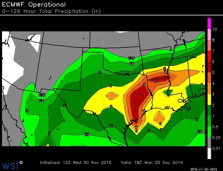
Rainfall Amounts:
Widespread rainfall amounts of 2-4 inches are likely over the next 5 days with most of this falling Saturday and Sunday. Expect the 2 inch totals more inland with the higher totals near the coast and offshore. Could see isolated amounts upwards of 6-7 inches over the coastal waters given forecasted PWS of 1.7-1.9 inches. Certainly the threat for heavy rainfall is there with those kind of PWS values, but current thinking is that the most concentrated convection will remain along and SE of US 59. Should the coastal trough track closer to the coast or slightly inland then rainfall amounts will need to be increased along and S of the US 59 corridor.

5-Day Forecasted Rainfall Amounts:
http://www.wpc.ncep.noaa.gov/qpf/p120i.gif?1480508139
Cold Air Outbreak:
Bitter cold air mass which has been stuck in Russia and Siberia for much of November has built into Alaska over Thanksgiving where current temperature readings are in the -30F to -40F range. Both the ECWMF and GFS along with several of their ensemble members develop an increasingly amplified upper air pattern next week over the northern Pacific which forces high pressure to build northward toward Alaska and then a deep downstream trough to form over the western US. This is certainly an upper level pattern favorable for delivery of a cold source region (Alaska) arctic air mass southward into the US. Given that the source region is actually fairly cold and expected to remain cold adds support to a significant intrusion of cold air into the plains by the middle to end of next week.
0 likes   
Skywarn, C.E.R.T.
Please click below to donate to STORM2K to help with the expenses of keeping the site going:
Image

Brent
S2K Supporter
S2K Supporter
Posts: 37988
Age: 36
Joined: Sun May 16, 2004 10:30 pm
Location: Tulsa Oklahoma
Contact:

Re: Texas Winter 2016-2017

#165 Postby Brent » Wed Nov 30, 2016 3:38 pm

Low of 25 at DFW on the euro next Thursday and highs in the 30s... very little warmup out to next Saturday morning
0 likes   
#neversummer

gpsnowman
S2K Supporter
S2K Supporter
Posts: 3157
Joined: Fri Jan 07, 2011 10:35 am
Location: Grand Prairie Tx

Re: Texas Winter 2016-2017

#166 Postby gpsnowman » Wed Nov 30, 2016 7:08 pm

I may as well start posting in the winter thread. It sounds better! Looks like a very wet weekend and into Monday for a large portion of Texas. A Saturday with my daughter watching movies and drinking hot cocoa watching the rain is just what the doctor ordered. Happy winter everyone!!! :cold: :cold: :froze: :froze: :D
2 likes   

User avatar
gboudx
S2K Supporter
S2K Supporter
Posts: 4080
Joined: Thu Sep 04, 2003 1:39 pm
Location: Rockwall, Tx but from Harvey, La

Re: Texas Winter 2016-2017

#167 Postby gboudx » Wed Nov 30, 2016 9:20 pm

gpsnowman wrote:I may as well start posting in the winter thread. It sounds better! Looks like a very wet weekend and into Monday for a large portion of Texas. A Saturday with my daughter watching movies and drinking hot cocoa watching the rain is just what the doctor ordered. Happy winter everyone!!! :cold: :cold: :froze: :froze: :D


I hear ya. The weather will be perfect for me to focus on my MBA studies. When it's nice outside, I can almost always find something that needs to be done outside around the house. I won't have those distractions this weekend; except for Saints football on Sunday. :)
0 likes   

Lagreeneyes03
Category 2
Category 2
Posts: 558
Joined: Mon Dec 09, 2013 10:53 am
Location: Luxurious Lake Grapevine

Re: Texas Winter 2016-2017

#168 Postby Lagreeneyes03 » Wed Nov 30, 2016 9:43 pm

Brent wrote:Low of 25 at DFW on the euro next Thursday and highs in the 30s... very little warmup out to next Saturday morning


Any chance for some precipitation to go along with those temps? I hate for them to go to waste.
0 likes   
I'm a Princess, not a forecaster.

weatherdude1108
Category 5
Category 5
Posts: 4228
Joined: Tue Dec 13, 2011 1:04 pm
Location: Northwest Austin/Cedar Park, TX

Re: Texas Winter 2016-2017

#169 Postby weatherdude1108 » Wed Nov 30, 2016 9:43 pm

Just heard Jim Spencer, a local TV weatherman on KXAN here in Austin say "...a week from today, we think the strongest cold front since last Winter, will bring freezing weather EVERYWHERE."

:cold:
1 likes   
The preceding post is NOT an official forecast, and should not be used as such. It is only the opinion of the poster and may or may not be backed by sound meteorological data. It is NOT endorsed by any professional institution including storm2k.org. For Official Information please refer to the NHC and NWS products.

weatherdude1108
Category 5
Category 5
Posts: 4228
Joined: Tue Dec 13, 2011 1:04 pm
Location: Northwest Austin/Cedar Park, TX

Re: Texas Winter 2016-2017

#170 Postby weatherdude1108 » Wed Nov 30, 2016 9:50 pm

Bob Rose's blog this afternoon:

Today's forecast data continues to indicate a strong cold front will push south across our region sometime late next Wednesday, ushering in some of the coldest air our region has seen in over a year. A freeze appears likely across the Hill Country and parts of Central Texas Thursday morning and across both regions Friday morning. High temperatures next Thursday are forecast to be mostly in the 40s, warming to around 50 degrees next Friday. Somewhat milder readings are expected next week. It still appears the weather will be dry late next week into next weekend, so there should be no problems with frozen precipitation.

I'll pass along another update on both weather situations on Thursday.

Bob


http://www.lcra.org/water/river-and-wea ... ather.aspx
0 likes   
The preceding post is NOT an official forecast, and should not be used as such. It is only the opinion of the poster and may or may not be backed by sound meteorological data. It is NOT endorsed by any professional institution including storm2k.org. For Official Information please refer to the NHC and NWS products.

Ralph's Weather
S2K Supporter
S2K Supporter
Posts: 3269
Age: 37
Joined: Fri Dec 13, 2013 11:55 am
Location: Lindale, TX
Contact:

Re: Texas Winter 2016-2017

#171 Postby Ralph's Weather » Wed Nov 30, 2016 10:33 pm

Already down to 37 here so starting winter off right with a low in the 30s. We will continue watching models for next week's storm.
0 likes   
Follow on Facebook at Ralph's Weather.

User avatar
South Texas Storms
Professional-Met
Professional-Met
Posts: 4198
Joined: Thu Jun 24, 2010 12:28 am
Location: Houston, TX

Re: Texas Winter 2016-2017

#172 Postby South Texas Storms » Wed Nov 30, 2016 10:44 pm

Looking forward to this winter. My long range coworker and I agree that much of Texas has an above average chance of snow this year.
1 likes   

Brent
S2K Supporter
S2K Supporter
Posts: 37988
Age: 36
Joined: Sun May 16, 2004 10:30 pm
Location: Tulsa Oklahoma
Contact:

Re: Texas Winter 2016-2017

#173 Postby Brent » Wed Nov 30, 2016 11:21 pm

WFAA just had 28 at DFW next Friday
0 likes   
#neversummer

User avatar
starsfan65
Category 2
Category 2
Posts: 704
Age: 47
Joined: Thu Dec 17, 2015 1:18 pm
Location: Garland,Tx

Re: Texas Winter 2016-2017

#174 Postby starsfan65 » Wed Nov 30, 2016 11:23 pm

Brent wrote:WFAA just had 28 at DFW next Friday
High of 45 on Thursday.
0 likes   

aggiecutter
Category 5
Category 5
Posts: 1751
Joined: Thu Oct 14, 2004 9:22 pm
Location: Texarkana

Re: Texas Winter 2016-2017

#175 Postby aggiecutter » Wed Nov 30, 2016 11:25 pm

December 83' all over, probably not. Still looks like it will get quite quite cold in the coming weeks. The only reason I am posting this is because I predicted a cold December. I think it's called confirmation bias. However, for those that live in SW Austin don't get too excited, the front will probably stall-out between Round Rock and Georgetown.


http://www.climatedepot.com/2016/11/30/ ... ntire-usa/
0 likes   

User avatar
starsfan65
Category 2
Category 2
Posts: 704
Age: 47
Joined: Thu Dec 17, 2015 1:18 pm
Location: Garland,Tx

Re: Texas Winter 2016-2017

#176 Postby starsfan65 » Wed Nov 30, 2016 11:26 pm

starsfan65 wrote:
Brent wrote:WFAA just had 28 at DFW next Friday
High of 45 on Thursday.
The 0z has the front coming in Wednesday morning.
0 likes   

Brent
S2K Supporter
S2K Supporter
Posts: 37988
Age: 36
Joined: Sun May 16, 2004 10:30 pm
Location: Tulsa Oklahoma
Contact:

Re: Texas Winter 2016-2017

#177 Postby Brent » Thu Dec 01, 2016 12:24 am

Yep... GFS has a high of 40 on Wednesday at DFW and then 29 Thursday morning. 40s on Thursday then quickly warms back up to the 60s by Saturday lol

CMC has the front later Wednesday afternoon, DFW still hits the 60s before it... then mid 20s Thursday and Friday morning.

Both models have rain totals around 2" between Saturday and Monday also. Sunday is the driest day of the three.

The Euro has almost 3" of rain Saturday-Monday, then brings in the front during the day Wednesday. DFW is in the 60s at daybreak, gets a little rain, and then temperatures fall into the 40s by evening. Has mid 20s Thursday morning and a high only in the mid 30s. Another morning in the 20s Friday with highs in the mid 40s Temperatures climb to about 50 degrees at 240 hours.
0 likes   
#neversummer

User avatar
Ntxw
Storm2k Moderator
Storm2k Moderator
Posts: 22730
Joined: Wed Oct 21, 2009 6:34 pm
Location: DFW, Texas

Re: Texas Winter 2016-2017

#178 Postby Ntxw » Thu Dec 01, 2016 6:31 am

Euro has very light precip behind the arctic front in the subfreezing air just west of the I-35 corridor next week. Still plenty of time to watch this progress. 27F was the winter low last year, lets see if we can at least beat that. For a good part of the last week we've been discussing this front and now the NWS WFO's are starting to chime in with the Arctic Express!

Image

Not to mention the widespread cold rain this weekend. It's turning out the system will drag in a lot more moisture than the guidance saw some days ago. Always tough when systems dig into Northern Mexico and we go blind from it. Widespread 1-3" for many (for December that's well above normal given we are now in dry season) and parts of southeast Texas near Houston may get even more. For DFW the rain may actually linger a second round on Monday due to wrapping around the system to continue the chilly raw light rain.
0 likes   
The above post and any post by Ntxw is NOT an official forecast and should not be used as such. It is just the opinion of the poster and may or may not be backed by sound meteorological data. It is NOT endorsed by any professional institution including Storm2k. For official information, please refer to NWS products.

  Help support Storm2K!
Help Support Storm2K

Ralph's Weather
S2K Supporter
S2K Supporter
Posts: 3269
Age: 37
Joined: Fri Dec 13, 2013 11:55 am
Location: Lindale, TX
Contact:

Re: Texas Winter 2016-2017

#179 Postby Ralph's Weather » Thu Dec 01, 2016 7:14 am

Another freeze here with a low of 30 so far this morning. Looking forward to the rain this weekend though hate rain with cold temps. This system looks to bring significant snow the the mountains of West Texas and southern NM with light snow through the Panhandle. We still will have to watch the track of the low as a shift north would flip those two bringing the heaviest snow to the Panhandle.
0 likes   
Follow on Facebook at Ralph's Weather.

User avatar
Ntxw
Storm2k Moderator
Storm2k Moderator
Posts: 22730
Joined: Wed Oct 21, 2009 6:34 pm
Location: DFW, Texas

Re: Texas Winter 2016-2017

#180 Postby Ntxw » Thu Dec 01, 2016 7:24 am

Ralph's Weather wrote:Another freeze here with a low of 30 so far this morning. Looking forward to the rain this weekend though hate rain with cold temps. This system looks to bring significant snow the the mountains of West Texas and southern NM with light snow through the Panhandle. We still will have to watch the track of the low as a shift north would flip those two bringing the heaviest snow to the Panhandle.


Low temps are over performing this morning where the winds have calmed. DFW is at 36F and may drop a little bit more while Fort Worth is at 40 with a light wind. Many surrounding sites are at or below freezing.
0 likes   
The above post and any post by Ntxw is NOT an official forecast and should not be used as such. It is just the opinion of the poster and may or may not be backed by sound meteorological data. It is NOT endorsed by any professional institution including Storm2k. For official information, please refer to NWS products.


  Help support Storm2K!

Help Support Storm2K


Return to “Winter Weather”

Who is online

Users browsing this forum: No registered users and 545 guests