Wet weekend for much of the state
Same cold front responsible for the 23 tornadoes overnight in LA, MS, AL of which one struck a 24-hr daycare at 213am this morning completely destroying the structure and critically injuring four children and resulting in 3 nearby fatalities, has pushed off the TX coast allowing a refreshingly dry air mass to overspread the region.
Cold air advection will continue today with temperatures slowly falling this morning into the 50’s across much of the entire area under N winds and a mid level cloud deck. Highs will only reach the mid to upper 60’s today compared to the record breaking mid 80’s on Tuesday. Coldest morning will be Thursday under clear skies and light winds and expect temperatures to fall into the upper 30’s NW to near 50 at the coast.
Friday-Sunday:
While there are still timing differences on when this weekend storm event will begin and end…models remain in good agreement that a very wet pattern will develop over SE TX.
Friday:
An upper level storm system will move from the NW US southward into NW MX and begin to cut off from the main jet stream flow aloft. The deep southern position of the upper level trough will begin to force surface pressure falls along the lower TX coast late Friday. Moisture will rapidly return across TX from both the Pacific and the Gulf of Mexico starting on Friday and we may begin to see showers break out by late Friday afternoon…which is a little faster than the previous thinking. Developing coastal low off the lower TX coast will lock in cold NE surface winds and cold air mass over the region with mid level moisture spreading northward over this surface cold dome.
Weekend:
SW flow aloft on the eastern flank of the NW MX upper level storm system and developed/NE tracking costal trough/low will result in messy conditions for the weekend. Strong overrunning of warm moist air above the surface cold layer will result in widespread rainfall from Saturday morning well into Sunday night and likely into Monday. Rainfall, clouds, and NE wind draining cold air in to the region will keep a near steady temperature through the entire period in the upper 40’s to mid 50’s.
Current thinking is that the coastal trough/low will progress from the lower TX coast late Saturday NE/ENE to off the upper TX coast by early Monday which will bring some marine impacts to winds and possibly tides. This track of the surface features and warm/cold sectors of the storm system favors the maximum rainfall totals to be along the coast and offshore as well as any severe weather threat. Should the surface low track inland or closer to the coast higher rainfall totals and severe weather would need to be added likely for Sunday.
Rainfall Amounts:
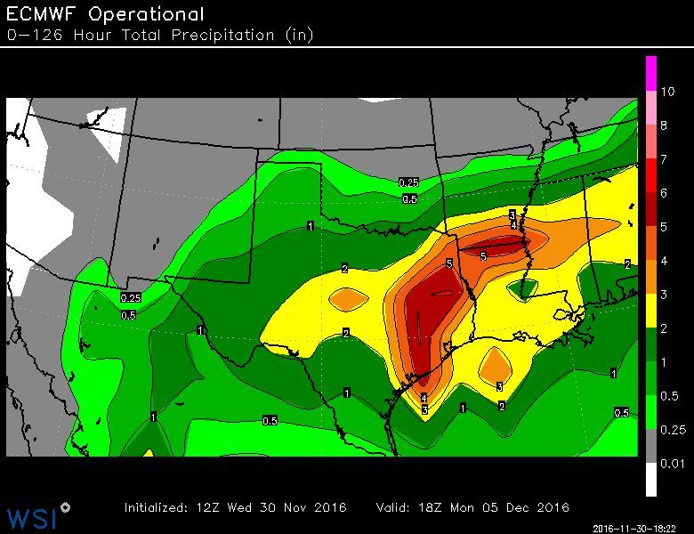
Widespread rainfall amounts of 2-4 inches are likely over the next 5 days with most of this falling Saturday and Sunday. Expect the 2 inch totals more inland with the higher totals near the coast and offshore. Could see isolated amounts upwards of 6-7 inches over the coastal waters given forecasted PWS of 1.7-1.9 inches. Certainly the threat for heavy rainfall is there with those kind of PWS values, but current thinking is that the most concentrated convection will remain along and SE of US 59. Should the coastal trough track closer to the coast or slightly inland then rainfall amounts will need to be increased along and S of the US 59 corridor.
5-Day Forecasted Rainfall Amounts:
http://www.wpc.ncep.noaa.gov/qpf/p120i.gif?1480508139Cold Air Outbreak:
Bitter cold air mass which has been stuck in Russia and Siberia for much of November has built into Alaska over Thanksgiving where current temperature readings are in the -30F to -40F range. Both the ECWMF and GFS along with several of their ensemble members develop an increasingly amplified upper air pattern next week over the northern Pacific which forces high pressure to build northward toward Alaska and then a deep downstream trough to form over the western US. This is certainly an upper level pattern favorable for delivery of a cold source region (Alaska) arctic air mass southward into the US. Given that the source region is actually fairly cold and expected to remain cold adds support to a significant intrusion of cold air into the plains by the middle to end of next week.


 The posts in this forum are NOT official forecast and should not be used as such. They are just the opinion of the poster and may or may not be backed by sound meteorological data. They are NOT endorsed by any professional institution or


