Texas Winter 2016-2017

Winter Weather Discussion

Moderator: S2k Moderators

Forum rules

The posts in this forum are NOT official forecast and should not be used as such. They are just the opinion of the poster and may or may not be backed by sound meteorological data. They are NOT endorsed by any professional institution or STORM2K.

Help Support Storm2K
Message
Author
User avatar
Ntxw
Storm2k Moderator
Storm2k Moderator
Posts: 22785
Joined: Wed Oct 21, 2009 6:34 pm
Location: DFW, Texas

Re: Texas Winter 2016-2017

#401 Postby Ntxw » Fri Dec 02, 2016 11:08 pm

Golf7070 wrote:
Ntxw wrote:
ThunderSleetDreams wrote:Heyoooo

https://twitter.com/MJVentrice/status/804786578136727552

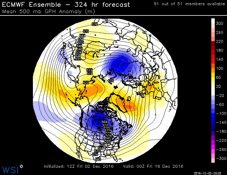
"Got to <3 this k=2 pattern setting up as a ridge overtakes the North Pole and splits the tropospheric polar vortex into two lobes"

https://pbs.twimg.com/media/CystH6GXcAAwByQ.jpg


Getting disturbed again up there for December, after being disturbed in November.

http://i64.tinypic.com/2pocyom.gif


Ntwx, what is mike ventrice trying to say with what he is referring to? Also, what is this diagram?


All supports a chilly pattern for continued opportunities of strong cold fronts this month
1 likes   
The above post and any post by Ntxw is NOT an official forecast and should not be used as such. It is just the opinion of the poster and may or may not be backed by sound meteorological data. It is NOT endorsed by any professional institution including Storm2k. For official information, please refer to NWS products.

  Help support Storm2K!
Help Support Storm2K

Brent
S2K Supporter
S2K Supporter
Posts: 38089
Age: 36
Joined: Sun May 16, 2004 10:30 pm
Location: Tulsa Oklahoma
Contact:

Re: Texas Winter 2016-2017

#402 Postby Brent » Fri Dec 02, 2016 11:10 pm

GFS is running... out to Wednesday morning with snow north of OKC. DFW in the low 40s. Low 50s at 18z and then 30s by 0z. Already upper 20s/around 30 at 6z Thursday. Freeze line approaching Austin.
0 likes   
#neversummer

User avatar
Ntxw
Storm2k Moderator
Storm2k Moderator
Posts: 22785
Joined: Wed Oct 21, 2009 6:34 pm
Location: DFW, Texas

Re: Texas Winter 2016-2017

#403 Postby Ntxw » Fri Dec 02, 2016 11:16 pm

Brent wrote:GFS is running... out to Wednesday morning with snow north of OKC. DFW in the low 40s. Low 50s at 18z and then 30s by 0z.


General consensus seems to be frontal passage Weds morning to midday. GFS does funny business, sending a front, retreating it, then sending it again. But it's clearly slowing things down and surging the cold dome southwards. It's quietly giving in to the ECMWF. It's also been trending wetter ahead of the front. There's now line of showers ahead which several runs ago there was none.
0 likes   
The above post and any post by Ntxw is NOT an official forecast and should not be used as such. It is just the opinion of the poster and may or may not be backed by sound meteorological data. It is NOT endorsed by any professional institution including Storm2k. For official information, please refer to NWS products.


  Help support Storm2K!

Help Support Storm2K


Brent
S2K Supporter
S2K Supporter
Posts: 38089
Age: 36
Joined: Sun May 16, 2004 10:30 pm
Location: Tulsa Oklahoma
Contact:

Re: Texas Winter 2016-2017

#404 Postby Brent » Fri Dec 02, 2016 11:17 pm

Ntxw wrote:
Brent wrote:GFS is running... out to Wednesday morning with snow north of OKC. DFW in the low 40s. Low 50s at 18z and then 30s by 0z.


General consensus seems to be frontal passage Weds morning to midday. GFS does funny business, sending a front, retreating it, then sending it again. But it's clearly slowing things down and surging the cold dome southwards. It's quietly giving in to the ECMWF.


it's definitely trending towards the Euro. 27-28 Thursday morning then only mid 30s at 18z. Austin near 30 degrees, freeze in the northern Houston sububs.
1 likes   
#neversummer

User avatar
Ntxw
Storm2k Moderator
Storm2k Moderator
Posts: 22785
Joined: Wed Oct 21, 2009 6:34 pm
Location: DFW, Texas

Re: Texas Winter 2016-2017

#405 Postby Ntxw » Fri Dec 02, 2016 11:19 pm

By Thursday afternoon, cold front is all the way down to Tampico
1 likes   
The above post and any post by Ntxw is NOT an official forecast and should not be used as such. It is just the opinion of the poster and may or may not be backed by sound meteorological data. It is NOT endorsed by any professional institution including Storm2k. For official information, please refer to NWS products.


  Help support Storm2K!

Help Support Storm2K


Brent
S2K Supporter
S2K Supporter
Posts: 38089
Age: 36
Joined: Sun May 16, 2004 10:30 pm
Location: Tulsa Oklahoma
Contact:

Re: Texas Winter 2016-2017

#406 Postby Brent » Fri Dec 02, 2016 11:19 pm

Look how far south the cold anomaiies are... :eek:

Image
1 likes   
#neversummer

JayDT
Category 1
Category 1
Posts: 354
Joined: Tue Dec 16, 2014 12:55 pm
Location: Dallas, Texas

Re: Texas Winter 2016-2017

#407 Postby JayDT » Fri Dec 02, 2016 11:22 pm

There we go GFS! :D Finally trending better I see. I hope it keeps trending colder though.
0 likes   

User avatar
Ntxw
Storm2k Moderator
Storm2k Moderator
Posts: 22785
Joined: Wed Oct 21, 2009 6:34 pm
Location: DFW, Texas

Re: Texas Winter 2016-2017

#408 Postby Ntxw » Fri Dec 02, 2016 11:23 pm

JayDT wrote:There we go GFS! :D Finally trending better I see. I hope it keeps trending colder though.


It's been back and forth. Like I said previously I don't get why we would put much stock in it when it hasn't been consistent. In the end, medium range the Euro will likely win again which for the most part has been consistent for this outbreak 7+ days out. As the time has come closer Euro has been starting to better focus on temps.

And I think GFS trying to warm it up on Weds afternoon above 50 is probably bogus. 850 front comes through Tuesday night/Weds morning and thats it for that.
0 likes   
The above post and any post by Ntxw is NOT an official forecast and should not be used as such. It is just the opinion of the poster and may or may not be backed by sound meteorological data. It is NOT endorsed by any professional institution including Storm2k. For official information, please refer to NWS products.


  Help support Storm2K!

Help Support Storm2K


JayDT
Category 1
Category 1
Posts: 354
Joined: Tue Dec 16, 2014 12:55 pm
Location: Dallas, Texas

Re: Texas Winter 2016-2017

#409 Postby JayDT » Fri Dec 02, 2016 11:29 pm

Ntxw wrote:
JayDT wrote:There we go GFS! :D Finally trending better I see. I hope it keeps trending colder though.


It's been back and forth. Like I said previously I don't get why we would put much stock in it when it hasn't been consistent. In the end, medium range the Euro will likely win again which for the most part has been consistent for this outbreak 7+ days out. As the time has come closer Euro has been starting to better focus on temps.

I was actually thinking about this earlier. The past few days that i've been model watching with everyone on here, the GFS has been pretty inconsistent while the Euro has been mostly consistent. So I was thinking the GFS obviously has to be the one that is off since it kept changing.
0 likes   

User avatar
Ntxw
Storm2k Moderator
Storm2k Moderator
Posts: 22785
Joined: Wed Oct 21, 2009 6:34 pm
Location: DFW, Texas

Re: Texas Winter 2016-2017

#410 Postby Ntxw » Fri Dec 02, 2016 11:37 pm

Crazy Canadian is still the coldest of the 3. GFS warmest and Euro somewhere in between.

Image

I still want to emphasize still not within 100 hours of the event yet. But we should be expecting frontal passage sometime between Tuesday night and Weds afternoon.
0 likes   
The above post and any post by Ntxw is NOT an official forecast and should not be used as such. It is just the opinion of the poster and may or may not be backed by sound meteorological data. It is NOT endorsed by any professional institution including Storm2k. For official information, please refer to NWS products.


  Help support Storm2K!

Help Support Storm2K


User avatar
Ntxw
Storm2k Moderator
Storm2k Moderator
Posts: 22785
Joined: Wed Oct 21, 2009 6:34 pm
Location: DFW, Texas

Re: Texas Winter 2016-2017

#411 Postby Ntxw » Fri Dec 02, 2016 11:44 pm

Also take notice of the trends (from the GFS) of the 5H vorticity rounding about the trough. Certainly a west and slowing component. Perhaps we may see it dig further south and west still? If it decides to dig into AZ/NM or N Mex then we would have more excitement with winter weather

Image
0 likes   
The above post and any post by Ntxw is NOT an official forecast and should not be used as such. It is just the opinion of the poster and may or may not be backed by sound meteorological data. It is NOT endorsed by any professional institution including Storm2k. For official information, please refer to NWS products.


  Help support Storm2K!

Help Support Storm2K


JayDT
Category 1
Category 1
Posts: 354
Joined: Tue Dec 16, 2014 12:55 pm
Location: Dallas, Texas

Re: Texas Winter 2016-2017

#412 Postby JayDT » Fri Dec 02, 2016 11:44 pm

Ntxw wrote:Crazy Canadian is still the coldest of the 3. GFS warmest and Euro somewhere in between.

Image

I still want to emphasize still not within 100 hours of the event yet. But we should be expecting frontal passage sometime between Tuesday night and Weds afternoon.

I really like the Crazy Canadian. :lol:
1 likes   

JayDT
Category 1
Category 1
Posts: 354
Joined: Tue Dec 16, 2014 12:55 pm
Location: Dallas, Texas

Re: Texas Winter 2016-2017

#413 Postby JayDT » Fri Dec 02, 2016 11:49 pm

If we could get some winter weather out of this, that would be the icing on the cake. Hopefully things trend that way
0 likes   

Brent
S2K Supporter
S2K Supporter
Posts: 38089
Age: 36
Joined: Sun May 16, 2004 10:30 pm
Location: Tulsa Oklahoma
Contact:

Re: Texas Winter 2016-2017

#414 Postby Brent » Fri Dec 02, 2016 11:54 pm

GFS has some wintry mischief at 300 hours around DFW

Image

Image
0 likes   
#neversummer

User avatar
Ntxw
Storm2k Moderator
Storm2k Moderator
Posts: 22785
Joined: Wed Oct 21, 2009 6:34 pm
Location: DFW, Texas

Re: Texas Winter 2016-2017

#415 Postby Ntxw » Fri Dec 02, 2016 11:55 pm

Brent wrote:GFS has some wintry mischief at 300 hours around DFW

http://www.tropicaltidbits.com/analysis ... cus_45.png


252hrs :lol:

Image
0 likes   
The above post and any post by Ntxw is NOT an official forecast and should not be used as such. It is just the opinion of the poster and may or may not be backed by sound meteorological data. It is NOT endorsed by any professional institution including Storm2k. For official information, please refer to NWS products.


  Help support Storm2K!

Help Support Storm2K


Brent
S2K Supporter
S2K Supporter
Posts: 38089
Age: 36
Joined: Sun May 16, 2004 10:30 pm
Location: Tulsa Oklahoma
Contact:

Re: Texas Winter 2016-2017

#416 Postby Brent » Fri Dec 02, 2016 11:58 pm

well that was a fun run lmao
1 likes   
#neversummer

User avatar
Ntxw
Storm2k Moderator
Storm2k Moderator
Posts: 22785
Joined: Wed Oct 21, 2009 6:34 pm
Location: DFW, Texas

Re: Texas Winter 2016-2017

#417 Postby Ntxw » Sat Dec 03, 2016 12:00 am

Canadian 240hrs

Image
0 likes   
The above post and any post by Ntxw is NOT an official forecast and should not be used as such. It is just the opinion of the poster and may or may not be backed by sound meteorological data. It is NOT endorsed by any professional institution including Storm2k. For official information, please refer to NWS products.


  Help support Storm2K!

Help Support Storm2K


JayDT
Category 1
Category 1
Posts: 354
Joined: Tue Dec 16, 2014 12:55 pm
Location: Dallas, Texas

Re: Texas Winter 2016-2017

#418 Postby JayDT » Sat Dec 03, 2016 12:04 am

So both the GFS and the Candian have that storm around the 13th? Interesting.
0 likes   

Brent
S2K Supporter
S2K Supporter
Posts: 38089
Age: 36
Joined: Sun May 16, 2004 10:30 pm
Location: Tulsa Oklahoma
Contact:

Re: Texas Winter 2016-2017

#419 Postby Brent » Sat Dec 03, 2016 12:08 am

If the GFS is right it's gonna be a long time before DFW hits 60 degrees again.
0 likes   
#neversummer

User avatar
Ntxw
Storm2k Moderator
Storm2k Moderator
Posts: 22785
Joined: Wed Oct 21, 2009 6:34 pm
Location: DFW, Texas

Re: Texas Winter 2016-2017

#420 Postby Ntxw » Sat Dec 03, 2016 12:15 am

While we wait on the Euro, Texas' radar is going to light up tonight into tomorrow morning to follow up on TPB's post of the HRRR. A large chunk of the state will be raining when we wake up. Southeast and central Texas first then further north. Many areas may get December's worth of rain in this single event.

Image

This system dug into Mexico and tapped into the subtropical jet

Image
2 likes   
The above post and any post by Ntxw is NOT an official forecast and should not be used as such. It is just the opinion of the poster and may or may not be backed by sound meteorological data. It is NOT endorsed by any professional institution including Storm2k. For official information, please refer to NWS products.


  Help support Storm2K!

Help Support Storm2K


Return to “Winter Weather”

Who is online

Users browsing this forum: Google Adsense [Bot] and 3 guests