Texas Winter 2016-2017
Moderator: S2k Moderators
Forum rules
 The posts in this forum are NOT official forecast and should not be used as such. They are just the opinion of the poster and may or may not be backed by sound meteorological data. They are NOT endorsed by any professional institution or STORM2K.

The posts in this forum are NOT official forecast and should not be used as such. They are just the opinion of the poster and may or may not be backed by sound meteorological data. They are NOT endorsed by any professional institution or STORM2K.
-
1900hurricane

- Category 5

- Posts: 6063
- Age: 34
- Joined: Fri Feb 06, 2015 12:04 pm
- Location: Houston, TX
- Contact:
Re: Texas Winter 2016-2017
I'd watch east of Covington for the cell to cycle back up.
0 likes
Contract Meteorologist. TAMU & MSST. Fiercely authentic, one of a kind. We are all given free will, so choose a life meant to be lived. We are the Masters of our own Stories.
Opinions expressed are mine alone.
Follow me on Twitter at @1900hurricane : Read blogs at https://1900hurricane.wordpress.com/
Opinions expressed are mine alone.
Follow me on Twitter at @1900hurricane : Read blogs at https://1900hurricane.wordpress.com/

Re: Texas Winter 2016-2017
1900hurricane wrote:Should have gone with my original idea for a target today, which was further north in Temple. I instead went down to Bastrop based on the convective trends at the time. Ooops (not that I was going to get a good view of any tornado anyway, with it becoming dark and all). The cell to the south running into the tornadic cell looks to have disrupted it for the time being at least.
Not far from us Austin folks.. (waves out the window towards the eastern horizon..)
0 likes
Resident Rain Miser
I am a weather hobbyist living 3.5 miles south of Downtown Austin and in no way or fashion should anything I say concerning forecasts be taken seriously. Please check your local NWS for accurate weather forecasting and conditions.
I am a weather hobbyist living 3.5 miles south of Downtown Austin and in no way or fashion should anything I say concerning forecasts be taken seriously. Please check your local NWS for accurate weather forecasting and conditions.
-
bubba hotep

- S2K Supporter

- Posts: 6014
- Joined: Wed Dec 28, 2016 1:00 am
- Location: Collin County Texas
Re: Texas Winter 2016-2017
Flash flooding threat for the DFW area would appear to be increasing based on radar. Threat was highlighted earlier this evening by WPC:
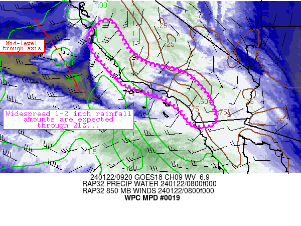
MESOSCALE PRECIPITATION DISCUSSION 0019
NWS WEATHER PREDICTION CENTER COLLEGE PARK MD
712 PM EST SUN JAN 15 2017
AREAS AFFECTED...CENTRAL TX...NORTH TX
CONCERNING...HEAVY RAINFALL...FLASH FLOODING POSSIBLE
VALID 160011Z - 160526Z
SUMMARY...TWO ROUNDS OF CONVECTION IN RAPID SUCCESSION WITHIN AN
INCREASINGLY EFFICIENT HEAVY RAIN ENVIRONMENT MAY CAUSE FLASH
FLOODING IN URBAN OR OTHER PARTICULARLY SENSITIVE AREAS.
DISCUSSION...THE ENVIRONMENT WAS PERHAPS FOREMOST A SEVERE WEATHER
ENVIRONMENT...BUT THE FLASH FLOOD POTENTIAL SHOULD NOT BE
UNDERESTIMATED AS SOUTH TO NORTH TRAINING BANDS OF CONVECTION WILL
BE QUICKLY FOLLOWED BY A QUASI-LINEAR SYSTEM. LATE AFTERNOON HRRR
RUNS HAD BEEN CONSISTENT AT PRODUCING ISOLATED TOTALS BETWEEN 2
AND 3 INCHES STRADDLING THE WARM FRONT / INTERSTATE 35 CORRIDOR
THROUGH 05Z. AT 00Z...THE INITIAL STORMS WERE TRAINING FROM ABOUT
190 DEGREES...FOLLOWING THE MEAN LOWER TO MID LEVEL WINDS...AS
BROAD SCALE LIFT INCREASED AHEAD OF THE EJECTING NEGATIVELY TILTED
MID LEVEL WAVE. THERE WAS A CORRESPONDING SUBTLE BACKING OF LOW
LEVEL FLOW OBSERVED PER RAP SOUNDINGS AND VAD WIND PROFILES FROM
FWS/GRK CONTRIBUTING TO THE TRAINING CELL MOTIONS.
OF PARTICULAR CONCERN...ONE-HOUR RAINFALL ESTIMATES FROM KFWS HAD
INCREASED ABOVE 2 INCHES WEST OF WACO AND HILLSBORO. THIS WAS
FAIRLY CLOSE TO THE RADAR AND AWAY FROM MELTING LAYER
ISSUES...SUCH THAT THERE IS LITTLE REASON TO DOUBT THE ESTIMATES.
PW VALUES WERE INCREASING TOWARD 1.4 INCHES IN THIS REGION AND
OTHER FACTORS SUCH AS INCREASING DEEP LAYER ASCENT AND LOW LEVEL
MOISTURE FLUX WILL FAVOR EFFICIENT RAINFALL PRODUCTION DESPITE
SOME SMALL HAIL.
FLASH FLOOD GUIDANCE VALUES ARE SOMEWHAT HIGH...BUT GIVEN THE
RECENT RADAR QPE TRENDS THE 3-HOUR FFG VALUES MAY BE EXCEEDED
WHEREVER THE S-N BANDS SET UP IN ADVANCE OF THE SQUALL LINE. WITH
THE WARM FRONT ALSO BISECTING THE DALLAS / FORT WORTH
METROPLEX...URBAN RUNOFF ISSUES MAY BECOME A FACTOR AS WELL.
BURKE
ATTN...WFO...EWX...FWD...SHV...
ATTN...RFC...ABRFC...LMRFC...WGRFC...
1 likes
Winter time post are almost exclusively focused on the DFW area.
-
bubba hotep
- S2K Supporter
- Posts: 6014
- Joined: Wed Dec 28, 2016 1:00 am
- Location: Collin County Texas
Re: Texas Winter 2016-2017
That cell is warned again

0 likes
Winter time post are almost exclusively focused on the DFW area.

Re: Texas Winter 2016-2017
This storm has a pretty impressive hook. Heads up Tarrant and Dallas county lines (southern areas)

The National Weather Service in Fort Worth has issued a
* Tornado Warning for...
Northeastern Johnson County in north central Texas...
* Until 815 PM CST
* At 744 PM CST, a severe thunderstorm capable of producing a tornado
was located over Grandview, or 7 miles south of Alvarado, moving
north at 25 mph.
HAZARD...Tornado.
SOURCE...Radar indicated rotation.
0 likes
The above post and any post by Ntxw is NOT an official forecast and should not be used as such. It is just the opinion of the poster and may or may not be backed by sound meteorological data. It is NOT endorsed by any professional institution including Storm2k. For official information, please refer to NWS products.
Help support Storm2K!
-
bubba hotep
- S2K Supporter
- Posts: 6014
- Joined: Wed Dec 28, 2016 1:00 am
- Location: Collin County Texas
Re: Texas Winter 2016-2017
So far, none of the CASA sites are getting a good look at that cell.
ETA: Now seeing it, looked pretty good just to the W of Venus, TX. Reports of power flashes as well.
ETA: Now seeing it, looked pretty good just to the W of Venus, TX. Reports of power flashes as well.
Last edited by bubba hotep on Sun Jan 15, 2017 9:09 pm, edited 1 time in total.
0 likes
Winter time post are almost exclusively focused on the DFW area.
Re: Texas Winter 2016-2017
Tornado warning just west/southwest of Kerrville, radar indicated.
0 likes
Resident Rain Miser
I am a weather hobbyist living 3.5 miles south of Downtown Austin and in no way or fashion should anything I say concerning forecasts be taken seriously. Please check your local NWS for accurate weather forecasting and conditions.
I am a weather hobbyist living 3.5 miles south of Downtown Austin and in no way or fashion should anything I say concerning forecasts be taken seriously. Please check your local NWS for accurate weather forecasting and conditions.
Re: Texas Winter 2016-2017
Per NBC5 power flashes reported by spotters near Venus
Moving towards Mansfield, I know we have some members from there
Moving towards Mansfield, I know we have some members from there
0 likes
The above post and any post by Ntxw is NOT an official forecast and should not be used as such. It is just the opinion of the poster and may or may not be backed by sound meteorological data. It is NOT endorsed by any professional institution including Storm2k. For official information, please refer to NWS products.
Help support Storm2K!
Help support Storm2K!
Re: Texas Winter 2016-2017
Okay found WFAA's stream
Last edited by JDawg512 on Sun Jan 15, 2017 9:26 pm, edited 1 time in total.
0 likes
Resident Rain Miser
I am a weather hobbyist living 3.5 miles south of Downtown Austin and in no way or fashion should anything I say concerning forecasts be taken seriously. Please check your local NWS for accurate weather forecasting and conditions.
I am a weather hobbyist living 3.5 miles south of Downtown Austin and in no way or fashion should anything I say concerning forecasts be taken seriously. Please check your local NWS for accurate weather forecasting and conditions.
Re: Texas Winter 2016-2017
0 likes
The above post and any post by Ntxw is NOT an official forecast and should not be used as such. It is just the opinion of the poster and may or may not be backed by sound meteorological data. It is NOT endorsed by any professional institution including Storm2k. For official information, please refer to NWS products.
Help support Storm2K!
Help support Storm2K!
-
bubba hotep
- S2K Supporter
- Posts: 6014
- Joined: Wed Dec 28, 2016 1:00 am
- Location: Collin County Texas
Re: Texas Winter 2016-2017
0 likes
The above post and any post by Ntxw is NOT an official forecast and should not be used as such. It is just the opinion of the poster and may or may not be backed by sound meteorological data. It is NOT endorsed by any professional institution including Storm2k. For official information, please refer to NWS products.
Help support Storm2K!
Help support Storm2K!
Re: Texas Winter 2016-2017
gboudx wrote:Hearing sirens Ntxw?
Yes and it is pouring. I'm going to have to log off for awhile
0 likes
The above post and any post by Ntxw is NOT an official forecast and should not be used as such. It is just the opinion of the poster and may or may not be backed by sound meteorological data. It is NOT endorsed by any professional institution including Storm2k. For official information, please refer to NWS products.
Help support Storm2K!
Help support Storm2K!
-
Texas Snowman

- Storm2k Moderator

- Posts: 6197
- Joined: Fri Jan 25, 2008 11:29 am
- Location: Denison, Texas
Re: Texas Winter 2016-2017
Ntxw, stay safe my friend!
0 likes
The above post and any post by Texas Snowman is NOT an official forecast and should not be used as such. It is just the opinion of the poster and may or may not be backed by sound meteorological data. It is NOT endorsed by any professional institution including storm2k.org. For official information, please refer to NWS products.
-
Texas Snowman
- Storm2k Moderator
- Posts: 6197
- Joined: Fri Jan 25, 2008 11:29 am
- Location: Denison, Texas
Re: Texas Winter 2016-2017
@DFWscanner - 8:46pm - Confirmed tornado is now in Grand Prairie near the Airport moving north. SEEK SHELTER NOW if you are in these areas.
0 likes
The above post and any post by Texas Snowman is NOT an official forecast and should not be used as such. It is just the opinion of the poster and may or may not be backed by sound meteorological data. It is NOT endorsed by any professional institution including storm2k.org. For official information, please refer to NWS products.
-
Texas Snowman
- Storm2k Moderator
- Posts: 6197
- Joined: Fri Jan 25, 2008 11:29 am
- Location: Denison, Texas
Re: Texas Winter 2016-2017
@TxStormChasers - Very dangerous situation in Grand Prairie.Confirmed Tornado earlier near GP airport, now moving NE to I-30 and Beltline. Take Shelter! #txwx
0 likes
The above post and any post by Texas Snowman is NOT an official forecast and should not be used as such. It is just the opinion of the poster and may or may not be backed by sound meteorological data. It is NOT endorsed by any professional institution including storm2k.org. For official information, please refer to NWS products.
Re: Texas Winter 2016-2017
It's awfully quiet in here for such an active weather night. I hope everyone up in DFW is okay..
0 likes
Resident Rain Miser
I am a weather hobbyist living 3.5 miles south of Downtown Austin and in no way or fashion should anything I say concerning forecasts be taken seriously. Please check your local NWS for accurate weather forecasting and conditions.
I am a weather hobbyist living 3.5 miles south of Downtown Austin and in no way or fashion should anything I say concerning forecasts be taken seriously. Please check your local NWS for accurate weather forecasting and conditions.
Re: Texas Winter 2016-2017
A little past 8:45pm I saw some green flashes to my southeast, nothing major here though. I'm close to 161 and beltline. Gotten a lot of rain since, a little over 2.5" on gauge. When the main line blew through it was much windier and looked worse than when the cell came through.
0 likes
The above post and any post by Ntxw is NOT an official forecast and should not be used as such. It is just the opinion of the poster and may or may not be backed by sound meteorological data. It is NOT endorsed by any professional institution including Storm2k. For official information, please refer to NWS products.
Help support Storm2K!
Help support Storm2K!
Re: Texas Winter 2016-2017
Tornado warning has been issued for central Kendall County. This storm seems to be edging northeastward towards the Austin Metro area.
0 likes
Resident Rain Miser
I am a weather hobbyist living 3.5 miles south of Downtown Austin and in no way or fashion should anything I say concerning forecasts be taken seriously. Please check your local NWS for accurate weather forecasting and conditions.
I am a weather hobbyist living 3.5 miles south of Downtown Austin and in no way or fashion should anything I say concerning forecasts be taken seriously. Please check your local NWS for accurate weather forecasting and conditions.
Who is online
Users browsing this forum: No registered users and 115 guests