Texas Winter 2016-2017

Winter Weather Discussion

Moderator: S2k Moderators

Forum rules

The posts in this forum are NOT official forecast and should not be used as such. They are just the opinion of the poster and may or may not be backed by sound meteorological data. They are NOT endorsed by any professional institution or STORM2K.

Help Support Storm2K
Message
Author
User avatar
Ntxw
Storm2k Moderator
Storm2k Moderator
Posts: 22786
Joined: Wed Oct 21, 2009 6:34 pm
Location: DFW, Texas

Re: Texas Winter 2016-2017

#4061 Postby Ntxw » Mon Jan 23, 2017 2:03 pm

wxman57 wrote:
ThunderSleetDreams wrote:Good Lord, you weren't kidding about 1+2

Niño 4
-0.1ºC
Niño 3.4
-0.2ºC
Niño 3
0.1ºC
Niño 1+2
1.6ºC


That's a very odd spike. I'm looking at the SST anomaly graphic on WxBell's site. There's a small pocket of very warm water near the coast of Mexico south of the Gulf of Tehuantepec. Otherwise, temps are close to normal or slightly below normal in the region.


Wxman57, Nino 1+2 is a small area near and west of Galapagos south towards the coast of Ecuador and Peru 0-10S, 90W-80W. Most of it lies in the southern hemisphere
0 likes   
The above post and any post by Ntxw is NOT an official forecast and should not be used as such. It is just the opinion of the poster and may or may not be backed by sound meteorological data. It is NOT endorsed by any professional institution including Storm2k. For official information, please refer to NWS products.

  Help support Storm2K!
Help Support Storm2K

User avatar
Ntxw
Storm2k Moderator
Storm2k Moderator
Posts: 22786
Joined: Wed Oct 21, 2009 6:34 pm
Location: DFW, Texas

Re: Texas Winter 2016-2017

#4062 Postby Ntxw » Mon Jan 23, 2017 2:21 pm

Verbatim Euro develops -EPO Alaskan ridge end of its run similar to the period the GFS had. 1050+ HP dome descending NW Canada. Generally the first run of -EPO from the Euro
0 likes   
The above post and any post by Ntxw is NOT an official forecast and should not be used as such. It is just the opinion of the poster and may or may not be backed by sound meteorological data. It is NOT endorsed by any professional institution including Storm2k. For official information, please refer to NWS products.


  Help support Storm2K!

Help Support Storm2K


User avatar
TeamPlayersBlue
Category 5
Category 5
Posts: 3445
Joined: Tue Feb 02, 2010 1:44 am
Location: Denver/Applewood, CO

Re: Texas Winter 2016-2017

#4063 Postby TeamPlayersBlue » Mon Jan 23, 2017 2:24 pm

Image

This is the best pic ive ever taken. Im going to take a photo from the exact same spot this year as well. Will update.
6 likes   
Personal Forecast Disclaimer:
The posts in this forum are NOT official forecast and should not be used as such. They are just the opinion of the poster and may or may not be backed by sound meteorological data. They are NOT endorsed by any professional institution or storm2k.org. For official information, please refer to the NHC and NWS products.

User avatar
wxman57
Moderator-Pro Met
Moderator-Pro Met
Posts: 22979
Age: 67
Joined: Sat Jun 21, 2003 8:06 pm
Location: Houston, TX (southwest)

Re: Texas Winter 2016-2017

#4064 Postby wxman57 » Mon Jan 23, 2017 2:36 pm

Ntxw wrote:
Wxman57, Nino 1+2 is a small area near and west of Galapagos south towards the coast of Ecuador and Peru 0-10S, 90W-80W. Most of it lies in the southern hemisphere


Right, I see it. That area is surrounded by temps below-normal. It's way warmer than the CFS forecast:

Image
0 likes   

User avatar
wxman57
Moderator-Pro Met
Moderator-Pro Met
Posts: 22979
Age: 67
Joined: Sat Jun 21, 2003 8:06 pm
Location: Houston, TX (southwest)

Re: Texas Winter 2016-2017

#4065 Postby wxman57 » Mon Jan 23, 2017 3:05 pm

TeamPlayersBlue wrote:http://i47.photobucket.com/albums/f192/TeamPlayersblue/2015-01-27160424-2_zpscfd316d6.jpg

This is the best pic ive ever taken. Im going to take a photo from the exact same spot this year as well. Will update.


I'll take a wild guess and say that's not taken in Sugar Land. Where did you take it?
0 likes   

User avatar
TeamPlayersBlue
Category 5
Category 5
Posts: 3445
Joined: Tue Feb 02, 2010 1:44 am
Location: Denver/Applewood, CO

Re: Texas Winter 2016-2017

#4066 Postby TeamPlayersBlue » Mon Jan 23, 2017 3:08 pm

wxman57 wrote:
TeamPlayersBlue wrote:http://i47.photobucket.com/albums/f192/TeamPlayersblue/2015-01-27160424-2_zpscfd316d6.jpg

This is the best pic ive ever taken. Im going to take a photo from the exact same spot this year as well. Will update.


I'll take a wild guess and say that's not taken in Sugar Land. Where did you take it?


International run at Crested Butte, CO. This was 2 years ago. They werent having a very strong year that year, this year should be vastly different.
0 likes   
Personal Forecast Disclaimer:
The posts in this forum are NOT official forecast and should not be used as such. They are just the opinion of the poster and may or may not be backed by sound meteorological data. They are NOT endorsed by any professional institution or storm2k.org. For official information, please refer to the NHC and NWS products.

User avatar
Ntxw
Storm2k Moderator
Storm2k Moderator
Posts: 22786
Joined: Wed Oct 21, 2009 6:34 pm
Location: DFW, Texas

Re: Texas Winter 2016-2017

#4067 Postby Ntxw » Mon Jan 23, 2017 3:12 pm

wxman57 wrote:
Ntxw wrote:
Wxman57, Nino 1+2 is a small area near and west of Galapagos south towards the coast of Ecuador and Peru 0-10S, 90W-80W. Most of it lies in the southern hemisphere


Right, I see it. That area is surrounded by temps below-normal. It's way warmer than the CFS forecast:

http://www.cpc.ncep.noaa.gov/products/C ... o12Mon.gif


Are you looking at a current anoms map? Its mostly above 1C in that region
http://www.nhc.noaa.gov/tafb/pac_anom.gif

Even more impressive is below the surface, all warm. What I'm wondering is if the long duration -SOI kicks off onset of early WWB. None yet so far but worth keeping an eye on in Feb
0 likes   
The above post and any post by Ntxw is NOT an official forecast and should not be used as such. It is just the opinion of the poster and may or may not be backed by sound meteorological data. It is NOT endorsed by any professional institution including Storm2k. For official information, please refer to NWS products.


  Help support Storm2K!

Help Support Storm2K


User avatar
wxman57
Moderator-Pro Met
Moderator-Pro Met
Posts: 22979
Age: 67
Joined: Sat Jun 21, 2003 8:06 pm
Location: Houston, TX (southwest)

Re: Texas Winter 2016-2017

#4068 Postby wxman57 » Mon Jan 23, 2017 3:29 pm

Ntxw wrote:
Are you looking at a current anoms map? Its mostly above 1C in that region
http://www.nhc.noaa.gov/tafb/pac_anom.gif

Even more impressive is below the surface, all warm. What I'm wondering is if the long duration -SOI kicks off onset of early WWB. None yet so far but worth keeping an eye on in Feb


Yeah, that's what I was looking at. Area just to the north remains below-normal. Here's what I was looking at.

Image
0 likes   

User avatar
Ntxw
Storm2k Moderator
Storm2k Moderator
Posts: 22786
Joined: Wed Oct 21, 2009 6:34 pm
Location: DFW, Texas

Re: Texas Winter 2016-2017

#4069 Postby Ntxw » Mon Jan 23, 2017 3:38 pm

Its a small pocket of cool in what is a +PDO, warm epac MDR. Likely the reason this Nina never got off the ground to a stronger event. A strong Nina tends to be cold S of the Equator off South America but has been kaboshed.
0 likes   
The above post and any post by Ntxw is NOT an official forecast and should not be used as such. It is just the opinion of the poster and may or may not be backed by sound meteorological data. It is NOT endorsed by any professional institution including Storm2k. For official information, please refer to NWS products.


  Help support Storm2K!

Help Support Storm2K


User avatar
wxman57
Moderator-Pro Met
Moderator-Pro Met
Posts: 22979
Age: 67
Joined: Sat Jun 21, 2003 8:06 pm
Location: Houston, TX (southwest)

Re: Texas Winter 2016-2017

#4070 Postby wxman57 » Mon Jan 23, 2017 4:55 pm

Look! Snow in the northern Panhandle February 5th! Warm superbowl in Houston.

Image
0 likes   

User avatar
TeamPlayersBlue
Category 5
Category 5
Posts: 3445
Joined: Tue Feb 02, 2010 1:44 am
Location: Denver/Applewood, CO

Re: Texas Winter 2016-2017

#4071 Postby TeamPlayersBlue » Mon Jan 23, 2017 5:09 pm

1000 MB low in South Texas with no moisture, wont believe it! :)
1 likes   
Personal Forecast Disclaimer:
The posts in this forum are NOT official forecast and should not be used as such. They are just the opinion of the poster and may or may not be backed by sound meteorological data. They are NOT endorsed by any professional institution or storm2k.org. For official information, please refer to the NHC and NWS products.

User avatar
Ntxw
Storm2k Moderator
Storm2k Moderator
Posts: 22786
Joined: Wed Oct 21, 2009 6:34 pm
Location: DFW, Texas

Re: Texas Winter 2016-2017

#4072 Postby Ntxw » Mon Jan 23, 2017 5:50 pm

18z GFS showing -EPO alaskan block. Starting to get consistent between runs and different models zoning in on Super Bowl weekend for EPO blast. That early Feb 1989 analog.
1 likes   
The above post and any post by Ntxw is NOT an official forecast and should not be used as such. It is just the opinion of the poster and may or may not be backed by sound meteorological data. It is NOT endorsed by any professional institution including Storm2k. For official information, please refer to NWS products.


  Help support Storm2K!

Help Support Storm2K


User avatar
bubba hotep
S2K Supporter
S2K Supporter
Posts: 5837
Joined: Wed Dec 28, 2016 1:00 am
Location: Collin County Texas

Re: Texas Winter 2016-2017

#4073 Postby bubba hotep » Mon Jan 23, 2017 9:05 pm

Ntxw wrote:12z GFS is back to -EPO with Calender change. Not 300hrs but 200+.

Feb 1989 lurks :D


I'm not sure that is the loading pattern that we want to see. It also looks like that run continues cyclonic wave breaking throughout the run maintaining ridging on the West Coast.

Image

It looks like we will have to wait for cyclonic wave breaking off the West Coast to give up before seeing any chance at legit cold. The 18z GFS was a step in the right direction in the longer range and the 18z GEFS was even better.

Image

Still, the 12z Euro EPS was even better with a transition to anticyclonic wave breaking, -PNA, Pacific Jet Retraction, the whole package. It looks to be primed for a major -EPO driven dump by D15.

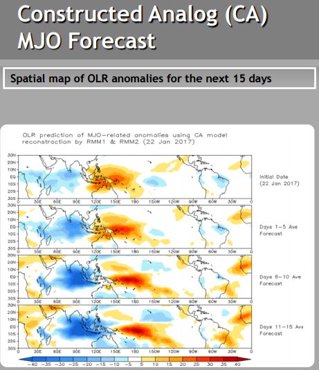
The 12z Euro EPS looks a lot like the Feb '89 loading pattern:

Image

and it has the retracted jet as well:

Image

The projected pattern in the Pacific also gives credence to the Euro EPS version of things:

Image

The D6 - 15 are pretty much what we want to see. As of the runs today, our best last chance at a big cold snap is probably in the Feb 7 - 12th period +/- some days.

However, all this probably changes at 00z tonight.
0 likes   
Winter time post are almost exclusively focused on the DFW area.

Golf7070
Tropical Storm
Tropical Storm
Posts: 115
Joined: Sun Oct 30, 2016 8:58 pm

Re: Texas Winter 2016-2017

#4074 Postby Golf7070 » Mon Jan 23, 2017 9:36 pm

Bubba, imo I think we will see some help from -ao sooner or later because of the ssw that has gotten underway. It won't be a big block but sometime in Feb we should see a period of -ao and possibly -nao.
0 likes   

User avatar
bubba hotep
S2K Supporter
S2K Supporter
Posts: 5837
Joined: Wed Dec 28, 2016 1:00 am
Location: Collin County Texas

Re: Texas Winter 2016-2017

#4075 Postby bubba hotep » Mon Jan 23, 2017 9:39 pm

Golf7070 wrote:Bubba, imo I think we will see some help from -ao sooner or later because of the ssw that has gotten underway. It won't be a big block but sometime in Feb we should see a period of -ao and possibly -nao.


I was seeing a lot more chatter online about SSW before this trend showed up:

Image

However, I don't really know enough to comment on what kind of sensible wx impacts that will have.
0 likes   
Winter time post are almost exclusively focused on the DFW area.

orangeblood
S2K Supporter
S2K Supporter
Posts: 3714
Joined: Tue Dec 15, 2009 6:14 pm
Location: Fort Worth, TX

Re: Texas Winter 2016-2017

#4076 Postby orangeblood » Tue Jan 24, 2017 9:06 am

Overnight teleconnection indices forecasts appear to be aligning to all head negative as we head into Feb (a positive for winter weather lovers), particularly the AO - latest forecasts show the potential for it to fall off a cliff in the coming days which aligns with the SSW we've been discussing around here lately. Very impressive episodes of Poleward heatflux towards the North Pacific side of the Stratosphere shown on most models - a constant barrage of these WAFz will hopefully continue to displace the PV towards the north slope of Siberia allowing for a longer duration negative AO. As Ntxw has mentioned, hopefully the negative AO is the key to breaking this pattern/increasing WW potential but I remain highly skeptical that the negative PNA is a good indice for us in the southern plains this winter - I've found most of our significant winter weather events to be with neutral to slightly positive PNAs.

Image
0 likes   

User avatar
Ntxw
Storm2k Moderator
Storm2k Moderator
Posts: 22786
Joined: Wed Oct 21, 2009 6:34 pm
Location: DFW, Texas

Re: Texas Winter 2016-2017

#4077 Postby Ntxw » Tue Jan 24, 2017 9:34 am

Ensembles do show raising heights in the polar regions which is a good sign to knock down the AO. Sure beats the sprawling tropospheric PV up near the pole now. Good trends overnight orangeblood. Perhaps the SSW will propogate down
0 likes   
The above post and any post by Ntxw is NOT an official forecast and should not be used as such. It is just the opinion of the poster and may or may not be backed by sound meteorological data. It is NOT endorsed by any professional institution including Storm2k. For official information, please refer to NWS products.


  Help support Storm2K!

Help Support Storm2K


User avatar
Portastorm
Storm2k Moderator
Storm2k Moderator
Posts: 9914
Age: 63
Joined: Fri Jul 11, 2003 9:16 am
Location: Round Rock, TX
Contact:

Re: Texas Winter 2016-2017

#4078 Postby Portastorm » Tue Jan 24, 2017 9:44 am

:uarrow:

The Southwest ridge which shows up in both the GFS and Euro long range is like our nasty summer high pressure, cockroach ridge. Both put their thumbs down on anything good! I'm hoping that the purported SSW event and the projected AO values shared by orangeblood above will shake things up. Cohen did say in his blog yesterday that the models often struggle at times like these when the polar vortex is disturbed and possibly breaking down.

Meanwhile, wxman57 is gleefully dancing on top of our heads. Record high temps today expected here in Austin.
0 likes   
Any forecasts under my name are to be taken with a grain of salt. Get your best forecasts from the National Weather Service and National Hurricane Center.

User avatar
Ntxw
Storm2k Moderator
Storm2k Moderator
Posts: 22786
Joined: Wed Oct 21, 2009 6:34 pm
Location: DFW, Texas

Re: Texas Winter 2016-2017

#4079 Postby Ntxw » Tue Jan 24, 2017 10:00 am

Portastorm wrote::uarrow:

The Southwest ridge which shows up in both the GFS and Euro long range is like our nasty summer high pressure, cockroach ridge. Both put their thumbs down on anything good! I'm hoping that the purported SSW event and the projected AO values shared by orangeblood above will shake things up. Cohen did say in his blog yesterday that the models often struggle at times like these when the polar vortex is disturbed and possibly breaking down.

Meanwhile, wxman57 is gleefully dancing on top of our heads. Record high temps today expected here in Austin.


SW ridge is +PNA. It can work and often does during El Nino if you have a subtropical jet cutting underneath connected to NW flow aloft. But it can also be an enemy if it progresses east or collapses into the southern plains. It's always nice to see a big trough coming out from our west digging through.

We are working diligently to foil his warm plans one last time this winter :cheesy:. I am actually looking forward to the NW flow. If anything it will cutoff the mountain cedar (for DFW) for a few weeks...

Image
0 likes   
The above post and any post by Ntxw is NOT an official forecast and should not be used as such. It is just the opinion of the poster and may or may not be backed by sound meteorological data. It is NOT endorsed by any professional institution including Storm2k. For official information, please refer to NWS products.


  Help support Storm2K!

Help Support Storm2K


User avatar
Ntxw
Storm2k Moderator
Storm2k Moderator
Posts: 22786
Joined: Wed Oct 21, 2009 6:34 pm
Location: DFW, Texas

Re: Texas Winter 2016-2017

#4080 Postby Ntxw » Tue Jan 24, 2017 11:21 am

If you want to see snow during +PNA this week, go east. NE Alabama, N Georgia and N Carolina has a good chance
0 likes   
The above post and any post by Ntxw is NOT an official forecast and should not be used as such. It is just the opinion of the poster and may or may not be backed by sound meteorological data. It is NOT endorsed by any professional institution including Storm2k. For official information, please refer to NWS products.


  Help support Storm2K!

Help Support Storm2K


Return to “Winter Weather”

Who is online

Users browsing this forum: No registered users and 4 guests