ATL: HARVEY - Post-Tropical - Discussion

Moderator: S2k Moderators

Message
Author
hd44

Re: ATL: HARVEY - Remnants - Discussion

#1181 Postby hd44 » Wed Aug 23, 2017 4:18 am

Image

Broad still as expected... but i think there are probably west on the southern portion of the axis.
1 likes   

hd44

Re: ATL: HARVEY - Remnants - Discussion

#1182 Postby hd44 » Wed Aug 23, 2017 4:19 am

This is producing winds to 35 mph... 5 mph short of ts if this pass is right.
0 likes   

Sciencerocks
Category 5
Category 5
Posts: 9155
Age: 39
Joined: Thu Jul 06, 2017 1:51 am

Re: ATL: HARVEY - Remnants - Discussion

#1183 Postby Sciencerocks » Wed Aug 23, 2017 4:24 am

You would be right as this now has westerly winds on the south side. Closed!

Image

Based on this data the LLC is centered a bit further south then I thought.
0 likes   

User avatar
northjaxpro
S2K Supporter
S2K Supporter
Posts: 8900
Joined: Mon Sep 27, 2010 11:21 am
Location: Jacksonville, FL

Re: ATL: HARVEY - Remnants - Discussion

#1184 Postby northjaxpro » Wed Aug 23, 2017 4:53 am

The upper level low south of the Louisiana coast basically has been stationary for the past 12-24 hours now. This in itself is very intriguing. This feature was supposed to have started to fill in and get lifted out to have the upper ridge direct the developing cyclone off the NW coast of the Yucatan Peninsula toward the northwest.

So far, the ULL is hanging tough and I do not see it pulling away at this juncture. I would not be shocked at all if models started shifting eastward. I think everyone along the Gulf Coast from NE MX to Mississippi needs to be paying serious attention with this situation the rest of this week!
Last edited by northjaxpro on Wed Aug 23, 2017 4:53 am, edited 1 time in total.
0 likes   
NEVER, EVER SAY NEVER in the tropics and weather in general, and most importantly, with life itself!!

________________________________________________________________________________________

Fay 2008 Beryl 2012 Debby 2012 Colin 2016 Hermine 2016 Julia 2016 Matthew 2016 Irma 2017 Dorian 2019

User avatar
drezee
S2K Supporter
S2K Supporter
Posts: 3664
Joined: Mon Jun 09, 2003 12:49 pm
Location: FL

Re: ATL: HARVEY - Remnants - Discussion

#1185 Postby drezee » Wed Aug 23, 2017 4:53 am

Not to be critical of NHC, but you have a clear closed low with a buoy west of it at 1009 mb. Rapidly deepening in a place that make no sense for it to rapidly deepen unless you have a system rapidly deepening. The buoy is in clean air hundreds of miles from the center...
http://www.ndbc.noaa.gov/station_page.php?station=42055

Please upgrade...this is a potentially deadly situation...
1 likes   

User avatar
drezee
S2K Supporter
S2K Supporter
Posts: 3664
Joined: Mon Jun 09, 2003 12:49 pm
Location: FL

Re: ATL: HARVEY - Remnants - Discussion

#1186 Postby drezee » Wed Aug 23, 2017 4:55 am

drezee wrote:Not to be critical of NHC, but you have a clear closed low with a buoy west of it at 1009 mb. Rapidly deepening in a place that make no sense for it to rapidly deepen unless you have a system rapidly deepening. The buoy is in clean air hundreds of miles from the center...
http://www.ndbc.noaa.gov/station_page.php?station=42055

Please upgrade...this is a potentially deadly situation...

There will be TS winds on oil rigs in less than 40 hours per the forecast...
1 likes   

User avatar
GCANE
S2K Supporter
S2K Supporter
Posts: 11500
Joined: Mon Oct 22, 2007 8:03 am

Re: ATL: HARVEY - Remnants - Discussion

#1187 Postby GCANE » Wed Aug 23, 2017 4:55 am

Good pressure drop at BoC Buoy

Image
0 likes   

User avatar
GCANE
S2K Supporter
S2K Supporter
Posts: 11500
Joined: Mon Oct 22, 2007 8:03 am

Re: ATL: HARVEY - Remnants - Discussion

#1188 Postby GCANE » Wed Aug 23, 2017 4:59 am

Convection starting to wrap.
New cell just north of CoC - close in.
If one fires on the west side in the drier slot, it'll be plugs out.
0 likes   

User avatar
ronjon
Category 5
Category 5
Posts: 4822
Joined: Fri Aug 19, 2005 5:17 pm
Location: Hernando Beach, FL

Re: ATL: HARVEY - Remnants - Discussion

#1189 Postby ronjon » Wed Aug 23, 2017 5:01 am

northjaxpro wrote:The upper level low south of the Louisiana coast basically has been stationary for the past 12-24 hours now. This in itself is very intriguing. This feature was supposed to have started to fill in and get lifted out to have the upper ridge direct the developing cyclone off the NW coast of the Yucatan Peninsula toward the northwest.

So far, the ULL is hanging tough and I do not see it pulling away at this juncture. I would not be shocked at all if models started shifting eastward. I think everyone along the Gulf Coast from NE MX to Mississippi needs to be paying serious attention with this situation the rest of this week!


The NAM and JMA show this solution which aren't the best models for tropical cyclones. I think there's a decent chance high pressure builds in and the storm stays just offshore of Tx and landfalls further east in La. The real disturbing trend is the increase now forecast in intensity.
0 likes   

stormreader

Re: ATL: HARVEY - Remnants - Discussion

#1190 Postby stormreader » Wed Aug 23, 2017 5:05 am

ronjon wrote:
northjaxpro wrote:The upper level low south of the Louisiana coast basically has been stationary for the past 12-24 hours now. This in itself is very intriguing. This feature was supposed to have started to fill in and get lifted out to have the upper ridge direct the developing cyclone off the NW coast of the Yucatan Peninsula toward the northwest.

So far, the ULL is hanging tough and I do not see it pulling away at this juncture. I would not be shocked at all if models started shifting eastward. I think everyone along the Gulf Coast from NE MX to Mississippi needs to be paying serious attention with this situation the rest of this week!


The NAM and JMA show this solution which aren't the best models for tropical cyclones. I think there's a decent chance high pressure builds in and the storm stays just offshore of Tx and landfalls further east in La. The real disturbing trend is the increase now forecast in intensity.

Really think that it stays offshore of TX. Still thinking Tex-La border, that's been my gut, but I think your point about somewhat further east is becoming more likely.
0 likes   

stormreader

Re: ATL: HARVEY - Remnants - Discussion

#1191 Postby stormreader » Wed Aug 23, 2017 5:09 am

Okay, I'm still not sure that maybe the storm is organizing a little north of the official plots given to us. You guys have checked out the ASCAT passes and interpreted them. Do they verify the official placement of the "center". Looking at simple visible, I am seeing some flow which looks like counterclockwise around the south end of a growing circulation (further north then the X on the chart). Could be wrong. Let me know.

Image
0 likes   

User avatar
Bizzles
Category 1
Category 1
Posts: 472
Age: 39
Joined: Wed Oct 27, 2010 10:22 am
Location: Columbus, NJ

Re: ATL: HARVEY - Remnants - Discussion

#1192 Postby Bizzles » Wed Aug 23, 2017 5:13 am

Still no 6AM TWO...think NHC is working on something...
0 likes   
Andrew '92 Opal '95 Blizzard '96 Izzy '03 Irene '11 Sandy '12

The following post is NOT an official forecast and should not be used as such. It is just the opinion is not be backed by sound meteorological data. It is NOT endorsed by any professional institution including storm2k.org For Official Information please refer to the NHC and NWS products.

hd44

Re: ATL: HARVEY - Remnants - Discussion

#1193 Postby hd44 » Wed Aug 23, 2017 5:15 am

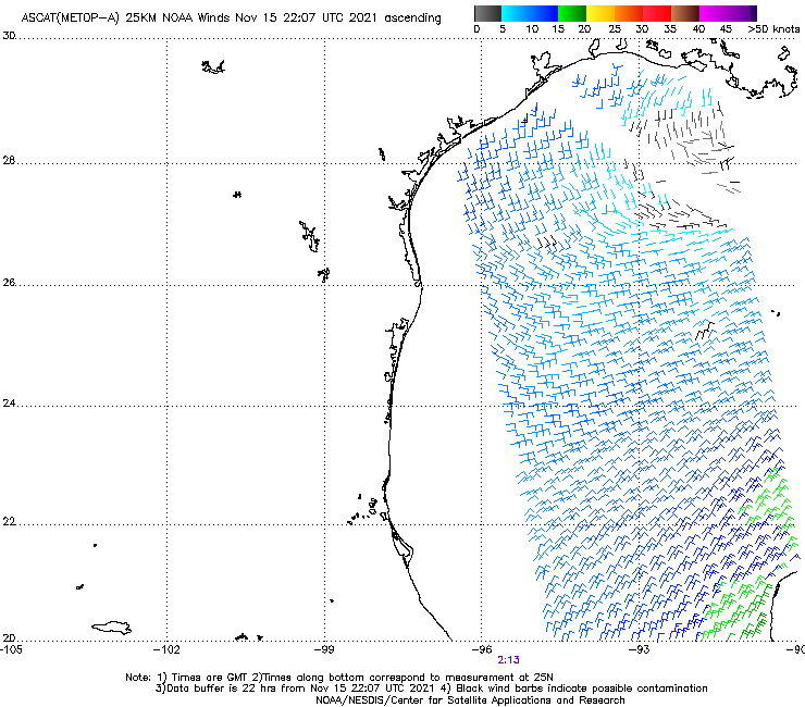
stormreader wrote:Okay, I'm still not sure that maybe the storm is organizing a little north of the official plots given to us. You guys have checked out the ASCAT passes and interpreted them. Do they verify the official placement of the "center". Looking at simple visible, I am seeing some flow which looks like counterclockwise around the south end of a growing circulation (further north then the X on the chart). Could be wrong. Let me know.

Image


Haven't gone to sleep today have been monitoring this system. I think it is still very elongated and the center is well south of the storms. Could still be a td with west winds and sufficient winds at 35 mph.
1 likes   

hd44

Re: ATL: HARVEY - Remnants - Discussion

#1194 Postby hd44 » Wed Aug 23, 2017 5:16 am

Bizzles wrote:Still no 6AM TWO...think NHC is working on something...


Two comes out at 8am, in 1.5 hours we will have an update !
0 likes   

SuperMarioBros99thx
Tropical Storm
Tropical Storm
Posts: 192
Age: 24
Joined: Sat Jul 08, 2017 7:38 am

Re: ATL: HARVEY - Remnants - Discussion

#1195 Postby SuperMarioBros99thx » Wed Aug 23, 2017 5:19 am

It seems that Harvey is fighting to absorb the ULL to the west of it.
(Update: Looked at the water vapor loop and it seems it doesn't)
Last edited by SuperMarioBros99thx on Wed Aug 23, 2017 5:23 am, edited 1 time in total.
1 likes   

User avatar
Bizzles
Category 1
Category 1
Posts: 472
Age: 39
Joined: Wed Oct 27, 2010 10:22 am
Location: Columbus, NJ

Re: ATL: HARVEY - Remnants - Discussion

#1196 Postby Bizzles » Wed Aug 23, 2017 5:19 am

hd44 wrote:
Bizzles wrote:Still no 6AM TWO...think NHC is working on something...


Two comes out at 8am, in 1.5 hours we will have an update !

Whoops! been a late night!
1 likes   
Andrew '92 Opal '95 Blizzard '96 Izzy '03 Irene '11 Sandy '12

The following post is NOT an official forecast and should not be used as such. It is just the opinion is not be backed by sound meteorological data. It is NOT endorsed by any professional institution including storm2k.org For Official Information please refer to the NHC and NWS products.

User avatar
Nimbus
Category 5
Category 5
Posts: 5303
Joined: Mon Jul 19, 2004 10:54 am

Re: ATL: HARVEY - Remnants - Discussion

#1197 Postby Nimbus » Wed Aug 23, 2017 5:26 am

The small vort that formed off the coast looks like it actually moved south about 30 miles overnight.
Pressure readings at buoy 42055 have been plummeting which might mean a center relocation is occurring to that area. Winds at the buoy are NNE at 19.4 kts so the center is still currently SSE of that area. In any event it appears Harvey pretty much stalled just off the coast at least temporarily which would mean a change in model timing.

If there is a ridge building l;ate in the forecast this could mean a track swing right in the model runs today.
1 likes   

User avatar
drezee
S2K Supporter
S2K Supporter
Posts: 3664
Joined: Mon Jun 09, 2003 12:49 pm
Location: FL

Re: ATL: HARVEY - Remnants - Discussion

#1198 Postby drezee » Wed Aug 23, 2017 5:56 am

Nimbus wrote:The small vort that formed off the coast looks like it actually moved south about 30 miles overnight.
Pressure readings at buoy 42055 have been plummeting which might mean a center relocation is occurring to that area. Winds at the buoy are NNE at 19.4 kts so the center is still currently SSE of that area. In any event it appears Harvey pretty much stalled just off the coast at least temporarily which would mean a change in model timing.

If there is a ridge building l;ate in the forecast this could mean a track swing right in the model runs today.


Doesn't have to mean the center moved...could mean it is deepening the pressure field quicker
0 likes   

stormreader

Re: ATL: HARVEY - Remnants - Discussion

#1199 Postby stormreader » Wed Aug 23, 2017 6:02 am

Nimbus wrote:The small vort that formed off the coast looks like it actually moved south about 30 miles overnight.
Pressure readings at buoy 42055 have been plummeting which might mean a center relocation is occurring to that area. Winds at the buoy are NNE at 19.4 kts so the center is still currently SSE of that area. In any event it appears Harvey pretty much stalled just off the coast at least temporarily which would mean a change in model timing.

If there is a ridge building l;ate in the forecast this could mean a track swing right in the model runs today.

Forward speed very important. Totally agree. Made the point yesterday that a slower approach to the coast would almost assuredly mean the storm would not get as far west as models showed. Agree, it looks as though it has moved very little in the last 12 hours or so. I think things are coming together for that track further east than mainline models have showed. Euro now very close to keeping storm off coast of Tx. Slow moving off the Yucatan, earlier effect of the ridging pushing back in from the west, would sure make one think that models would tend to keep this off the central TX coast. Still think that Tex-La border is best best. Slow mover might make one consider a tad further east. But too early for that just yet.
0 likes   

User avatar
GCANE
S2K Supporter
S2K Supporter
Posts: 11500
Joined: Mon Oct 22, 2007 8:03 am

Re: ATL: HARVEY - Remnants - Discussion

#1200 Postby GCANE » Wed Aug 23, 2017 6:02 am

Overnight convection appears to have been organized as an MCS.
WV Imagery suggests a MCV has been created resulting in a closed off Mid-Level Vort.
CoC of the Mid-level Vort appears NE of the LLC.

Image
0 likes   


Return to “2017”

Who is online

Users browsing this forum: No registered users and 0 guests