ATL: IRMA - Post-Tropical - Discussion
Moderator: S2k Moderators
-
Aric Dunn
- Category 5

- Posts: 21238
- Age: 43
- Joined: Sun Sep 19, 2004 9:58 pm
- Location: Ready for the Chase.
- Contact:
Re: ATL: IRMA - Hurricane - Discussion
soo live feeds ?
0 likes
Note: If I make a post that is brief. Please refer back to previous posts for the analysis or reasoning. I do not re-write/qoute what my initial post said each time.
If there is nothing before... then just ask
Space & Atmospheric Physicist, Embry-Riddle Aeronautical University,
I believe the sky is falling...
If there is nothing before... then just ask
Space & Atmospheric Physicist, Embry-Riddle Aeronautical University,
I believe the sky is falling...


Re: ATL: IRMA - Hurricane - Discussion
AdvAutoBob wrote:KBBOCA wrote:It's incredible how few folks are online here with an historic landfalling storm in SW FL and possible worst case scenarios of surge affecting Naples / Ft. Myers.
But so many S2K members are in FL, so obviously dealing with power loss / comms loss / exhaustion / evacuation...
Other key members (CycloneEye, MSBEE) are dealing with tragedy caused by Irma in the Caribbean...
And we've got a whole ton of folks in Houston and other Harvey-hit areas of Texas trying to rebuild their lives...
I've been monitoring, etc. and really too busy to post.
That being said, as of now (1:45):
North Ft Myers, steady winds now around 40-45MPH with gusts around hurricane strength. Numerous palm fronds on the ground at the moment, and I'm sure we'll have some downed trees once the eyewall hits (around 6PM according to local media)
All of that and storm fatigue. Hurricane news has been non-stop for over a week.
2 likes
-
stormreader
Re: ATL: IRMA - Hurricane - Discussion
GCANE wrote:

931 mb. Very low pressure. Hurricanes with that pressure normally have stronger sustained winds. But Irma's circulation was disrupted over Cuba, so I understand why sustained winds wouldn't be higher. However, my hunch is that with the frictional affects of the land at landfall near Naples, and with a pressure that low, that you could get gusts higher than many are counting on. Will see.
0 likes

Re: ATL: IRMA - Hurricane - Discussion
Aric Dunn wrote:soo live feeds ?
http://www.earthcam.com/events/extremeweather/
http://www.ustream.tv/channel/2TRywcaNHMV
0 likes
Alicia, Rita, Ike, Harvey and Beryl...moved to Splendora lol

Re: ATL: IRMA - Hurricane - Discussion
GCANE wrote:
Interesting. Bending back west of north. Wonder how long the center avoids actually making it inland like it did for Cuba.
1 likes
-
KBBOCA
- S2K Supporter

- Posts: 1559
- Joined: Fri Sep 05, 2003 5:27 am
- Location: Formerly Boca Raton, often West Africa. Currently Charlotte NC
Re: ATL: IRMA - Hurricane - Discussion
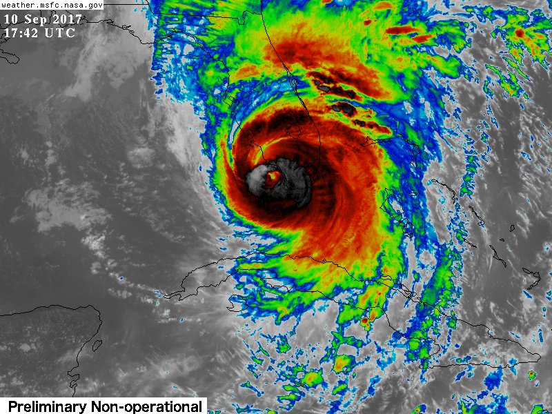
NWS Tampa BayVerified account @NWSTampaBay 11m11 minutes ago
The eyewall, with strongest wind, & surge potential with #IRMA close to Naples/Marco Island. Coastal #Lee & #Charlotte cntys are next. #flwx
https://twitter.com/NWSTampaBay/status/906934898279239685
The eyewall, with strongest wind, & surge potential with #IRMA close to Naples/Marco Island. Coastal #Lee & #Charlotte cntys are next. #flwx
https://twitter.com/NWSTampaBay/status/906934898279239685
0 likes

Re: ATL: IRMA - Hurricane - Discussion
MSNBC showed a "before" photo of Marco Island that Irma's eye wall is heading towards.
That flat highly populated urban island may get 15 feet of storm surge.
.
That flat highly populated urban island may get 15 feet of storm surge.
.
Last edited by toto on Sun Sep 10, 2017 1:17 pm, edited 1 time in total.
0 likes
-
stormreader
Re: ATL: IRMA - Hurricane - Discussion
DTMEDIC wrote:AdvAutoBob wrote:KBBOCA wrote:It's incredible how few folks are online here with an historic landfalling storm in SW FL and possible worst case scenarios of surge affecting Naples / Ft. Myers.
But so many S2K members are in FL, so obviously dealing with power loss / comms loss / exhaustion / evacuation...
Other key members (CycloneEye, MSBEE) are dealing with tragedy caused by Irma in the Caribbean...
And we've got a whole ton of folks in Houston and other Harvey-hit areas of Texas trying to rebuild their lives...
I've been monitoring, etc. and really too busy to post.
That being said, as of now (1:45):
North Ft Myers, steady winds now around 40-45MPH with gusts around hurricane strength. Numerous palm fronds on the ground at the moment, and I'm sure we'll have some downed trees once the eyewall hits (around 6PM according to local media)
All of that and storm fatigue. Hurricane news has been non-stop for over a week.
Eyewall to arrive at 6pm....gust at Naples already 103mph.
0 likes
-
KBBOCA
- S2K Supporter
- Posts: 1559
- Joined: Fri Sep 05, 2003 5:27 am
- Location: Formerly Boca Raton, often West Africa. Currently Charlotte NC
Re: ATL: IRMA - Hurricane - Discussion
John MoralesVerified account @JohnMoralesNBC6 14m14 minutes ago
Same spiral band moving through South Florida's metro area just yielded a 103 MPH gust at Naples Municipal Airport.
https://twitter.com/JohnMoralesNBC6/status/906934650307833856
Same spiral band moving through South Florida's metro area just yielded a 103 MPH gust at Naples Municipal Airport.
https://twitter.com/JohnMoralesNBC6/status/906934650307833856
0 likes
Re: ATL: IRMA - Hurricane - Discussion

URGENT - IMMEDIATE BROADCAST REQUESTED
Tornado Watch Number 483
NWS Storm Prediction Center Norman OK
1200 PM EDT Sun Sep 10 2017
The NWS Storm Prediction Center has issued a
* Tornado Watch for portions of
much of Florida
far southeast Georgia
Coastal Waters
* Effective this Sunday from NOON until Midnight EDT.
* Primary threats include...
A few tornadoes likely
Isolated significant damaging wind gusts to 75 mph possible
SUMMARY...Bands of convection associated with Hurricane Irma will
continue progressing north across Florida in conjunction with Irma's
advance, while individual/embedded cells within the bands move
quickly westward. Stronger cells will be capable of producing
tornadoes this afternoon and evening.
The tornado watch area is approximately along and 75 statute miles
east and west of a line from 15 miles west northwest of Jacksonville
FL to 40 miles southwest of Avon Park FL. For a complete depiction
of the watch see the associated watch outline update (WOUS64 KWNS
WOU3).
1 likes
-
stormreader
Re: ATL: IRMA - Hurricane - Discussion
tallywx wrote:GCANE wrote:
Interesting. Bending back west of north. Wonder how long the center avoids actually making it inland like it did for Cuba.
Naples will get raked with the NE quadrant, but if that path continues, official landfall would be further up the coast.
0 likes
-
ConvergenceZone
.gif)
- Category 5
- Posts: 5241
- Joined: Fri Jul 29, 2005 1:40 am
- Location: Northern California
Re: ATL: IRMA - Hurricane - Discussion
The direction looks to be slightly left of almost due North. Landfall coming up pretty quickly
0 likes
-
Janie2006

- Category 5
- Posts: 1329
- Joined: Mon Sep 18, 2006 3:28 pm
- Location: coastal Ms aka home of the hurricanes
Re: ATL: IRMA - Hurricane - Discussion
This is bad. Based on radar trends it's very well possible that Naples gets to stay in the NE and E eyewall for a good while rather than a direct-and-through hit.
Edited because I cannot type today.
Edited because I cannot type today.
Last edited by Janie2006 on Sun Sep 10, 2017 12:53 pm, edited 1 time in total.
0 likes
-
KBBOCA
- S2K Supporter
- Posts: 1559
- Joined: Fri Sep 05, 2003 5:27 am
- Location: Formerly Boca Raton, often West Africa. Currently Charlotte NC
Re: ATL: IRMA - Hurricane - Discussion
https://twitter.com/MJVentrice/status/9 ... 3810763776
Michael VentriceVerified account @MJVentrice 4m4 minutes ago
#Irma's eye sits just offshore of the southwestern tip of Florida.
Michael VentriceVerified account @MJVentrice 4m4 minutes ago
#Irma's eye sits just offshore of the southwestern tip of Florida.
0 likes
-
WeatherGuesser
- Category 5
- Posts: 2672
- Joined: Tue Jun 29, 2010 6:46 am
Re: ATL: IRMA - Hurricane - Discussion
Breaker-breaker good buddy, we got us a ConnnVoyyy.
Spotted 50-100 trucks this morning, combination of tree crews and power line crews passing through W KY towards Nashville, TN. Figure they'll be down there by late tomorrow sometime.
Spotted 50-100 trucks this morning, combination of tree crews and power line crews passing through W KY towards Nashville, TN. Figure they'll be down there by late tomorrow sometime.
5 likes
-
stormreader
Re: ATL: IRMA - Hurricane - Discussion
Janie2006 wrote:This is bad. Based on radar trends it's very well possible that Naples gets to stay in the NE and E eyewall for a god while rather than a direct-and-through hit.
You're right. That can be worse.
0 likes
-
wx247

- S2K Supporter
- Posts: 14279
- Age: 42
- Joined: Wed Feb 05, 2003 10:35 pm
- Location: Monett, Missouri
- Contact:
Re: ATL: IRMA - Hurricane - Discussion
Looking like the eye may not make landfall for a bit longer now. Wobbles will tell the story, but it looks like it may be further up the coast than Naples. Going to be close call.
0 likes
Personal Forecast Disclaimer:
The posts in this forum are NOT official forecast and should not be used as such. They are just the opinion of the poster and may or may not be backed by sound meteorological data. They are NOT endorsed by any professional institution or storm2k.org. For official information, please refer to the NHC and NWS products.
The posts in this forum are NOT official forecast and should not be used as such. They are just the opinion of the poster and may or may not be backed by sound meteorological data. They are NOT endorsed by any professional institution or storm2k.org. For official information, please refer to the NHC and NWS products.
-
AdamFirst

- S2K Supporter
- Posts: 2490
- Age: 36
- Joined: Thu Aug 14, 2008 10:54 am
- Location: Port Saint Lucie, FL
Re: ATL: IRMA - Hurricane - Discussion
Power surged here for the first time this storm...lights flickered and Comcast boxes reset.
0 likes
Dolphins Marlins Canes Golden Panthers HEAT
Andrew 1992 - Irene 1999 - Frances 2004 - Jeanne 2004 - Wilma 2005 - Fay 2008 - Isaac 2012 - Matthew 2016 - Irma 2017 - Dorian 2019 - Ian 2022 - Nicole 2022 - Milton 2024
Andrew 1992 - Irene 1999 - Frances 2004 - Jeanne 2004 - Wilma 2005 - Fay 2008 - Isaac 2012 - Matthew 2016 - Irma 2017 - Dorian 2019 - Ian 2022 - Nicole 2022 - Milton 2024
-
KBBOCA
- S2K Supporter
- Posts: 1559
- Joined: Fri Sep 05, 2003 5:27 am
- Location: Formerly Boca Raton, often West Africa. Currently Charlotte NC
Re: ATL: IRMA - Hurricane - Discussion
Mark SudduthVerified account @hurricanetrack
Brief video discussion featuring our longtime friend and colleague Mike Watkins from Oakland Park Florida...
https://youtu.be/hPHZskPNFyE
https://twitter.com/hurricanetrack/status/906927313442439168
Brief video discussion featuring our longtime friend and colleague Mike Watkins from Oakland Park Florida...
https://youtu.be/hPHZskPNFyE
https://twitter.com/hurricanetrack/status/906927313442439168
6 likes
Who is online
Users browsing this forum: No registered users and 55 guests