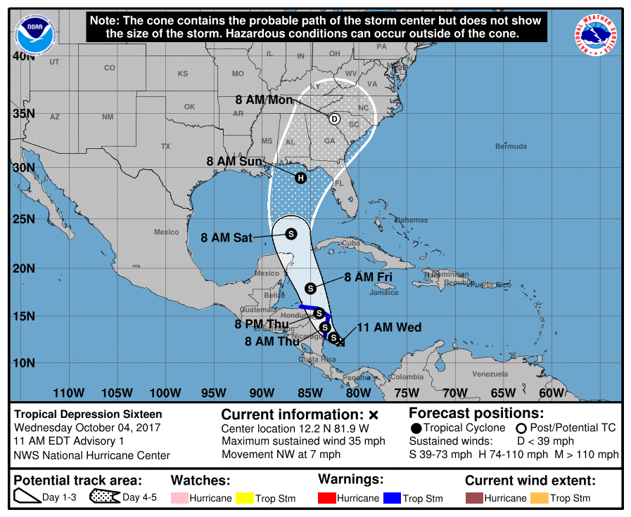
Special Message from NHC Issued 4 Oct 2017 14:02 UTC
NHC will initiate advisories at 11 AM EDT on Tropical Depression Sixteen, currently located over the Southwestern Caribbean Sea.
ATL: NATE - Post Tropical - Discussion
Moderator: S2k Moderators
Re: ATL: INVEST 90L - Models
1 likes
-
SunnyThoughts
- Category 5

- Posts: 2263
- Joined: Wed Jul 09, 2003 12:42 pm
- Location: Pensacola, Florida
Re: ATL: INVEST 90L - Discussion
Special Message from NHC Issued 4 Oct 2017 14:02 UTC
NHC will initiate advisories at 11 AM EDT on Tropical Depression Sixteen, currently located over the Southwestern Caribbean Sea.
NHC will initiate advisories at 11 AM EDT on Tropical Depression Sixteen, currently located over the Southwestern Caribbean Sea.
1 likes

Re: ATL: INVEST 90L - Models
rockyman wrote:Special Message from NHC Issued 4 Oct 2017 14:02 UTC
NHC will initiate advisories at 11 AM EDT on Tropical Depression Sixteen, currently located over the Southwestern Caribbean Sea.
....and there we have it. Even prior to recon; must've finally picked up a ship's report or corroborating buoy data.
1 likes
Andy D
(For official information, please refer to the NHC and NWS products.)
(For official information, please refer to the NHC and NWS products.)

Re: ATL: INVEST 90L - Discussion
The forecasted track at the 11 AM Advisory will most likely be a compromise between the GFS and the Euro, IMO.
1 likes
-
gatorcane

- S2K Supporter

- Posts: 23708
- Age: 48
- Joined: Sun Mar 13, 2005 3:54 pm
- Location: Boca Raton, FL
Re: ATL: INVEST 90L - Models
00Z NASA model continues to show an EGOM solution just west of the west coast of Florida:

1 likes
Re: ATL: INVEST 90L - Discussion
Wow, already a TD. That means the model consensus is already underdoing the strength and this probably gives it 4 full days to strengthen from here before landfall, a scary thought considering the very high heat content it will be traversing.
1 likes
Personal Forecast Disclaimer:
The posts in this forum are NOT official forecasts and should not be used as such. They are just the opinion of the poster and may or may not be backed by sound meteorological data. They are NOT endorsed by any professional institution or storm2k.org. For official information, please refer to the NHC and NWS products.
The posts in this forum are NOT official forecasts and should not be used as such. They are just the opinion of the poster and may or may not be backed by sound meteorological data. They are NOT endorsed by any professional institution or storm2k.org. For official information, please refer to the NHC and NWS products.
-
chris_fit

- Category 5
- Posts: 3261
- Age: 43
- Joined: Wed Sep 10, 2003 11:58 pm
- Location: Tampa Bay Area, FL
Re: ATL: INVEST 90L - Discussion
I curious on what the Tornado threat to the FL Peninsula would be, assuming Future Nate stays to the West.
0 likes
Re: ATL: INVEST 90L - Discussion
chris_fit wrote:I curious on what the Tornado threat to the FL Peninsula would be, assuming Future Nate stays to the West.
It will depend how close it gets to the Peninsula as most times the tornadic cells are found on the NE quadrant of the storm.
0 likes
-
SunnyThoughts
- Category 5
- Posts: 2263
- Joined: Wed Jul 09, 2003 12:42 pm
- Location: Pensacola, Florida

Re: ATL: INVEST 90L - Discussion
I do think the GFS is too far west with soon to be TD 16. That means the SHIPs output probably has too much land interaction and may be under-doing the RI stats.
0 likes

Re: ATL: INVEST 90L - Models
I am worried about the East shift that could happen on this one. I think West Coast of Florida Ft. Myers North need to watch out.
https://twitter.com/MJVentrice/status/915567655733559297
https://twitter.com/MJVentrice/status/915567655733559297
2 likes
The following post is NOT an official forecast and should not be used as such. It is just the opinion of the poster and may or may not be backed by sound meteorological data. It is NOT endorsed by any professional institution including storm2k.org For Official Information please refer to the NHC and NWS products.
Re: ATL: SIXTEEN - Tropical Depression - Discussion
OUTLOOK VALID 08/1200Z 29.0N 86.0W
MAX WIND 70 KT...GUSTS 85 KT.
NHC brings a cat 1 into the FL Panhandle.
MAX WIND 70 KT...GUSTS 85 KT.
NHC brings a cat 1 into the FL Panhandle.
0 likes
-
Blown Away

- S2K Supporter
- Posts: 10253
- Joined: Wed May 26, 2004 6:17 am
Re: ATL: SIXTEEN - Tropical Depression - Discussion
RL3AO wrote:OUTLOOK VALID 08/1200Z 29.0N 86.0W
MAX WIND 70 KT...GUSTS 85 KT.
NHC brings a cat 1 into the FL Panhandle.
Classic October "Low Confidence" in track late in forecast...
1 likes
Hurricane Eye Experience: David 79, Irene 99, Frances 04, Jeanne 04, Wilma 05… Hurricane Brush Experience: Andrew 92, Erin 95, Floyd 99, Matthew 16, Irma 17, Ian 22, Nicole 22…
-
otowntiger
- Category 5
- Posts: 1932
- Joined: Tue Aug 31, 2004 7:06 pm
Re: ATL: INVEST 90L - Models
I understand. I didn't mean to sound unsympathetic as we had/and are experiencing identical issues here in Orlando. Irma was intense and huge bringing hurricane conditions across most of the peninnusula including inland areas. I just don't see this one (as currently forecast) being as intense or as big. But I realize a T.S. could do harm to coastal areas still recovering. Of course track, intensity and size could all change in a way that make the effects much more drastic.caneman wrote:caneman wrote:otowntiger wrote: Even if it does track closer to you as the Euro is still the eastern outlier, indications are it will still be not all that strong- t.s or weak and small cat 1. A storm that small and weak won't have catastrophic effects.
It doesn't have to be catastrophic to affect you. I was without power for 5 days, spent hundreds of extra dollars, work was closed for a week, kids missed a week of school, tons of cleanup, to have an impact and that was just wind and no surge. We also have a bunch of missiles laying around. The news hammered the power companies, cable companies but for the most part have given the local and county governments a pass. There is still debris everywhere more than 3 weeks later.
1 likes
Re: ATL: SIXTEEN - Models
From NHC discussion:
The GFS-based
guidance seems to over-amplify the trough, which causes the
new tropical cyclone to be pulled northwestward longer than most of
the rest of the models. Consequently, this forecast is closer to the
UKMET and ECMWF models, on the right side of the model consensus,
but must be considered a low-confidence prediction at this time.
0 likes
The following post is NOT an official forecast and should not be used as such. It is just the opinion of the poster and may or may not be backed by sound meteorological data. It is NOT endorsed by any professional institution including storm2k.org For Official Information please refer to the NHC and NWS products.
-
gtalum

- S2K Supporter
- Posts: 4749
- Age: 50
- Joined: Tue Sep 07, 2004 3:48 pm
- Location: Bradenton, FL
- Contact:
Re: ATL: SIXTEEN - Tropical Depression - Discussion
The crazy thing is almost nobody is talking about this, but in 3-4 days it's almost certain to hit somebody on the Gulf Coast. Let's hope for low intensity.
0 likes
Re: ATL: SIXTEEN - Tropical Depression - Discussion
0 likes
The following post is NOT an official forecast and should not be used as such. It is just the opinion of the poster and may or may not be backed by sound meteorological data. It is NOT endorsed by any professional institution including storm2k.org For Official Information please refer to the NHC and NWS products.
-
Stormcenter
- S2K Supporter
- Posts: 6689
- Joined: Wed Sep 03, 2003 11:27 am
- Location: Houston, TX
Re: ATL: SIXTEEN - Tropical Depression - Discussion
This is going to be a very tricky forecast and I would not bet a single penny on it right now. IMO
0 likes
-
crm6360
Re: ATL: INVEST 90L - Models
Right, we should trust an amateur instead.SEASON_CANCELED wrote:carried over from TTfci wrote:
Please. Again with the Armageddon type post.
"Hermine", "Wilma"????
"Catastrophe" in earlier post...
How about a possible sheared TS like the Pro Mets are saying?
Never trust models or promets that far out.
2 likes
Who is online
Users browsing this forum: No registered users and 13 guests