Cold and wet today with rain or a rain snow mix possible tonight.
A few reports of sleet this morning in the Jersey Village, Barker, and Sugar Land areas where radar indicated extensive bright banding (high reflectivity from the beam striking the melting snow/sleet aloft). AM soundings show a very deep warm layer at Corpus Christi and nearly 4700 ft above freezing at Lake Charles. Del Rio has falling nearly completely below freezing through the entire column and reports indicate rainfall has changed to snow along the Rio Grande and there is some minor accumulation in progress.
Rain will continue for much of the day as SW flow aloft overruns the cold dense surface dome. A surge of drier air will begin to arrive this evening and gradually decrease precipitation from N to S across the region. As this happens the depth of the sub-freezing layer will gradually increase and this may allow the rain to begin to mix with snow of even change to snow. The big question becomes if there is enough moisture in the air column by the time the profile becomes favorable for snow to reach the surface. The NAM and the HRRR indicate a bit more moisture and more pronounced impulse over the area which results in precipitation continuing past midnight for areas south of I-10 and a better chance for mixed phase. The GFS and TX TECH WRF shows the drier air winning the battle and shutting down the precipitation as the thermal profiles become favorable.
Think the best chances for a rain/snow mix of complete change to snow will be across SC TX into the coastal bend from roughly Matagorda Bay SW toward Laredo where HRRR accumulation runs show amounts of .10 to 1 inch Friday morning. Dynamic cooling looks greatest in this area and reflectivity forecasts show some degree of meso type banding which would support some decent rates if a complete changeover can occur. These higher rates could locally cool the surface temperature toward freezing allowing some accumulation. Could extend the mix area as far NE as Brazoria and Galveston Counties, but moisture becomes a big “if” in these areas. If the NAM is correct this mix would extend up to about I-10 if not to Hwy 105 and accumulations would even be possible over a large portion of SE TX.
Will need to watch trends closely today for even a slight increase in moisture tonight as this would increase the chances for snow across the region. Will also need to take a hard look at surface temperatures today for early Friday morning as sub-freezing temperatures could affect portions of the region (mainly N of HWY 105) and any residual water could freeze on bridges and overpasses.
Forecast confidence is low and there could be changes today.
Texas Winter 2017-2018
Moderator: S2k Moderators
Forum rules
 The posts in this forum are NOT official forecast and should not be used as such. They are just the opinion of the poster and may or may not be backed by sound meteorological data. They are NOT endorsed by any professional institution or STORM2K.

The posts in this forum are NOT official forecast and should not be used as such. They are just the opinion of the poster and may or may not be backed by sound meteorological data. They are NOT endorsed by any professional institution or STORM2K.
-
gboudx

- S2K Supporter

- Posts: 4090
- Joined: Thu Sep 04, 2003 1:39 pm
- Location: Rockwall, Tx but from Harvey, La
Re: Texas Winter 2017-2018
Update from jeff:
1 likes

Re: Texas Winter 2017-2018
TeamPlayersBlue wrote:Could this be ascent coming from the "front" coming down. This is the same boundary that will lower temps aloft for us.
Like Wxman sais, i havent been watching weather at this great of detail long but havent seen heights this low over us before. Its apparent in the GFS. Maybe this is why models are struggling with the precip type.
Ntx, been watching the SPC map as well, thats the key for when the turnover will happen. 850 0C line needs to make it to the coast, 925MB has to be near the Houston area for some luck. Not seeing in any way of sleet or snowflakes here either like Wxman said earlier. Sounding profile shows how thats not exactly possible or could be widespread.
Glad to see Dallas area seeing some flurries!!!! You guys never seem to miss out hahaha
Currently 44 and holding at TPB. It was 43F at daybreak.
Not to jinx us, Also like to remind you guys which model saw this first..... Crazy Uncle CMC himself.
The vorticity coming down from the north is what kicks out the energy to your west, making it less "positive tilt"
And yes, it always finds a way to snow in DFW when someone else is supposed to get it
2 likes
The above post and any post by Ntxw is NOT an official forecast and should not be used as such. It is just the opinion of the poster and may or may not be backed by sound meteorological data. It is NOT endorsed by any professional institution including Storm2k. For official information, please refer to NWS products.
Help support Storm2K!
-
TeamPlayersBlue

- Category 5

- Posts: 3533
- Joined: Tue Feb 02, 2010 1:44 am
- Location: Denver/Applewood, CO
Re: Texas Winter 2017-2018
0 likes
Personal Forecast Disclaimer:
The posts in this forum are NOT official forecast and should not be used as such. They are just the opinion of the poster and may or may not be backed by sound meteorological data. They are NOT endorsed by any professional institution or storm2k.org. For official information, please refer to the NHC and NWS products.
The posts in this forum are NOT official forecast and should not be used as such. They are just the opinion of the poster and may or may not be backed by sound meteorological data. They are NOT endorsed by any professional institution or storm2k.org. For official information, please refer to the NHC and NWS products.
-
ThunderSleetDreams

- S2K Supporter
- Posts: 1510
- Age: 43
- Joined: Tue Dec 20, 2011 4:42 pm
- Location: S of Weimar, TX
Re: Texas Winter 2017-2018
Looking at the medium and long range ensembles, the pattern doesn't change much. At its warmest, it is seasonal.
I did notice that the GFS operational is the outlier past 240 hours. It doesn't line up with the upper air pattern at all.
I did notice that the GFS operational is the outlier past 240 hours. It doesn't line up with the upper air pattern at all.
2 likes
#NeverSummer
I hibernate when it gets above 75 degrees!
I hibernate when it gets above 75 degrees!
Re: Texas Winter 2017-2018
DFW western and northern burbs could get a nice burst of snow before noon, looking at radar/precip type.
2 likes
Re: Texas Winter 2017-2018
Tejas89 wrote:DFW western and northern burbs could get a nice burst of snow before noon, looking at radar/precip type.
Some stronger reflectivity is coming in form the southwest. It's an all snow profile up here.

0 likes
The above post and any post by Ntxw is NOT an official forecast and should not be used as such. It is just the opinion of the poster and may or may not be backed by sound meteorological data. It is NOT endorsed by any professional institution including Storm2k. For official information, please refer to NWS products.
Help support Storm2K!
Help support Storm2K!

Re: Texas Winter 2017-2018
What is the likelihood of snow sticking in DFW? It's definitely not cold enough right now.
0 likes
Graduate Meteorology Student at the University of Oklahoma!
All opinions independent of employers and the university.
All opinions independent of employers and the university.
Re: Texas Winter 2017-2018
Cerlin wrote:What is the likelihood of snow sticking in DFW? It's definitely not cold enough right now.
Dewpoints are in the 20s. If it snows heavy enough the temp will drop to near freezing. If not it will mostly be showers and flurries that won't stick. But the layer above is very cold.
https://twitter.com/NWSFortWorth/status/938795550232776704
1 likes
The above post and any post by Ntxw is NOT an official forecast and should not be used as such. It is just the opinion of the poster and may or may not be backed by sound meteorological data. It is NOT endorsed by any professional institution including Storm2k. For official information, please refer to NWS products.
Help support Storm2K!
Help support Storm2K!
-
Hurricane_Apu
- Tropical Storm

- Posts: 124
- Joined: Tue Aug 31, 2004 5:47 pm
-
TeamPlayersBlue
- Category 5
- Posts: 3533
- Joined: Tue Feb 02, 2010 1:44 am
- Location: Denver/Applewood, CO
Re: Texas Winter 2017-2018
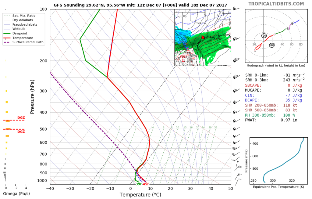
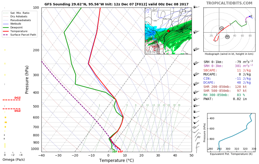
Latest GFS soundings for Sugar Land area
6 hours out
12 hours out
18 hours out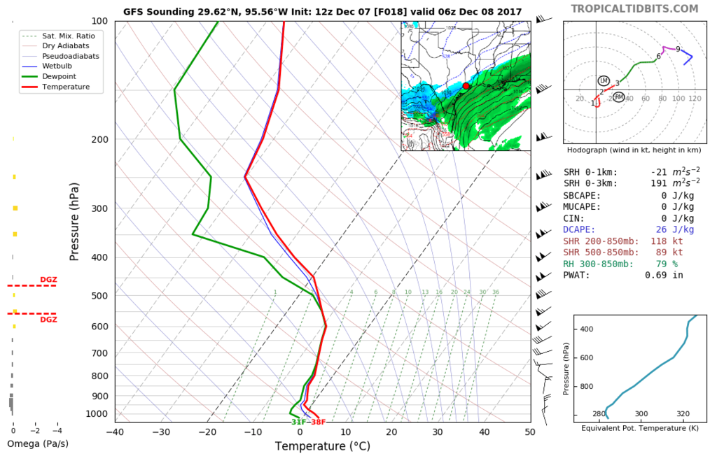
6 hours out

12 hours out

18 hours out

0 likes
Personal Forecast Disclaimer:
The posts in this forum are NOT official forecast and should not be used as such. They are just the opinion of the poster and may or may not be backed by sound meteorological data. They are NOT endorsed by any professional institution or storm2k.org. For official information, please refer to the NHC and NWS products.
The posts in this forum are NOT official forecast and should not be used as such. They are just the opinion of the poster and may or may not be backed by sound meteorological data. They are NOT endorsed by any professional institution or storm2k.org. For official information, please refer to the NHC and NWS products.
-
TeamPlayersBlue
- Category 5
- Posts: 3533
- Joined: Tue Feb 02, 2010 1:44 am
- Location: Denver/Applewood, CO
Re: Texas Winter 2017-2018
Could the snow shield thats lined up with DFW progress southward towards Austin?
0 likes
Personal Forecast Disclaimer:
The posts in this forum are NOT official forecast and should not be used as such. They are just the opinion of the poster and may or may not be backed by sound meteorological data. They are NOT endorsed by any professional institution or storm2k.org. For official information, please refer to the NHC and NWS products.
The posts in this forum are NOT official forecast and should not be used as such. They are just the opinion of the poster and may or may not be backed by sound meteorological data. They are NOT endorsed by any professional institution or storm2k.org. For official information, please refer to the NHC and NWS products.
-
bubba hotep

- S2K Supporter
- Posts: 6014
- Joined: Wed Dec 28, 2016 1:00 am
- Location: Collin County Texas
Re: Texas Winter 2017-2018
Wife said there is a mix of sleet & snow up at the house in Collin County.
0 likes
Winter time post are almost exclusively focused on the DFW area.
Re: Texas Winter 2017-2018
Ntxw wrote:Cerlin wrote:What is the likelihood of snow sticking in DFW? It's definitely not cold enough right now.
Dewpoints are in the 20s. If it snows heavy enough the temp will drop to near freezing. If not it will mostly be showers and flurries that won't stick. But the layer above is very cold.
https://twitter.com/NWSFortWorth/status/938795550232776704
So you’re saying there’s a chance??
1 likes
-
BrokenGlassRepublicn
- Category 1

- Posts: 483
- Joined: Sun Nov 20, 2011 8:07 pm
- Location: Richardson, Texas
Re: Texas Winter 2017-2018
Ntxw wrote:For you NTX people, some light reflectivity
viewtopic.php?f=22&t=117967&start=4600[img]http://i64.tinypic.com/2vry5nc.png
I thought I saw a few flakes as I was driving out to Frisco this morning.
0 likes
-
Theepicman116
- Tropical Depression

- Posts: 95
- Age: 26
- Joined: Sat Nov 26, 2016 10:43 pm
- Location: Stephenville
Re: Texas Winter 2017-2018
So that snow in Abilene. Will it make its way up to the DFW area? More specifically Fort Worth, North Richland Hills, Keller, Colleyville and Southlake area. Or will the dry air kill it before it can reach us.
We’re getting flurries here in Keller. I just want to know if the snow will or could make it this far?
We’re getting flurries here in Keller. I just want to know if the snow will or could make it this far?
0 likes
-
Portastorm

- Storm2k Moderator

- Posts: 9955
- Age: 63
- Joined: Fri Jul 11, 2003 9:16 am
- Location: Round Rock, TX
- Contact:
Re: Texas Winter 2017-2018
It's okay guys but I do appreciate the sentiments. When you expect nothing and expect to get screwed over when there's a possibility ... then it becomes easier to accept. After all of these years of heartbreak, that's where I am. Seriously.
You folks getting snowed in places that don't see much snow ... enjoy it! Take lots of pictures and make some memories.
You folks getting snowed in places that don't see much snow ... enjoy it! Take lots of pictures and make some memories.
5 likes
Any forecasts under my name are to be taken with a grain of salt. Get your best forecasts from the National Weather Service and National Hurricane Center.
-
jaguars_22
- Category 2

- Posts: 629
- Joined: Tue Jun 20, 2017 2:26 pm
- Location: Victoria TX
Re: Texas Winter 2017-2018
Does anyone on here think that this may be a decent size snow storm for same areas hit in 04?? Something tells me this is going to be exciting.
Exactly where is the low supposed to form?? along coast
Exactly where is the low supposed to form?? along coast
0 likes
-
wxman57

- Moderator-Pro Met

- Posts: 23175
- Age: 68
- Joined: Sat Jun 21, 2003 8:06 pm
- Location: Houston, TX (southwest)
Re: Texas Winter 2017-2018
Note that we have decided on 2 balloon launches today. First will be at 18Z, second near 03Z. They're launched from the University of Houston. Data will be sent to the local NWS office. I'll post it here, too. I'm interested in seeing how well the models are handling the temps aloft.
6 likes
-
TeamPlayersBlue
- Category 5
- Posts: 3533
- Joined: Tue Feb 02, 2010 1:44 am
- Location: Denver/Applewood, CO
Re: Texas Winter 2017-2018
jaguars_22 wrote:Does anyone on here think that this may be a decent size snow storm for same areas hit in 04?? Something tells me this is going to be exciting.
Exactly where is the low supposed to form?? along coast
I was joking with Ntx about bringing up '04, saying, "NO WAY!" but after reanalyzing the '04 storm and todays storm, there are many similarities. One difference is the dry air coming in a tad quicker i think than in '04, but its possible the models thought the same thing in '04 since it was supposed to be a non event.
0 likes
Personal Forecast Disclaimer:
The posts in this forum are NOT official forecast and should not be used as such. They are just the opinion of the poster and may or may not be backed by sound meteorological data. They are NOT endorsed by any professional institution or storm2k.org. For official information, please refer to the NHC and NWS products.
The posts in this forum are NOT official forecast and should not be used as such. They are just the opinion of the poster and may or may not be backed by sound meteorological data. They are NOT endorsed by any professional institution or storm2k.org. For official information, please refer to the NHC and NWS products.
Who is online
Users browsing this forum: No registered users and 80 guests