Texas Winter 2017-2018
Moderator: S2k Moderators
Forum rules
 The posts in this forum are NOT official forecast and should not be used as such. They are just the opinion of the poster and may or may not be backed by sound meteorological data. They are NOT endorsed by any professional institution or STORM2K.

The posts in this forum are NOT official forecast and should not be used as such. They are just the opinion of the poster and may or may not be backed by sound meteorological data. They are NOT endorsed by any professional institution or STORM2K.
-
orangeblood
- S2K Supporter

- Posts: 3895
- Joined: Tue Dec 15, 2009 6:14 pm
- Location: Fort Worth, TX
Re: Texas Winter 2017-2018
1070 HP on Canadian and 1060 HP on GFS for same time frame next week. Also, anyone notice Canadian trying to go negative tilt on Friday night with Rain changing to snow ?
2 likes
-
aggiecutter
- Category 5

- Posts: 1754
- Joined: Thu Oct 14, 2004 9:22 pm
- Location: Texarkana
Re: Texas Winter 2017-2018
stormlover2013 wrote:Lol it will change guys don’t get to giddy, when models keep pushing it back then they have no clue lol
This is not about the models. It is about the pattern. Cold air meeting active sub-tropical jet means I-30, 1-20 winter storm. It's inevitable.
The posts in this forum are NOT official forecast and should not be used as such. They are just the opinion of the poster and may or may not be backed by sound meteorological data. They are NOT endorsed by any professional institution or STORM2K.
0 likes
-
stormlover2013
-
Rgv20

- S2K Supporter
- Posts: 2466
- Age: 39
- Joined: Wed Jan 05, 2011 5:42 pm
- Location: Edinburg/McAllen Tx
Re: Texas Winter 2017-2018
The forecast model struggle continues to no surprise here. Looks like they are really struggling with this upcoming pattern change, many more model changes to go! 
0 likes
The following post is NOT an official forecast and should not be used as such. It is just the opinion of the poster and may or may not be backed by sound meteorological data. It is NOT endorsed by any professional institution including storm2k.org For Official Information please refer to the NHC and NWS products.
-
Brent
- S2K Supporter
- Posts: 38708
- Age: 37
- Joined: Sun May 16, 2004 10:30 pm
- Location: Tulsa Oklahoma
- Contact:
Re: Texas Winter 2017-2018
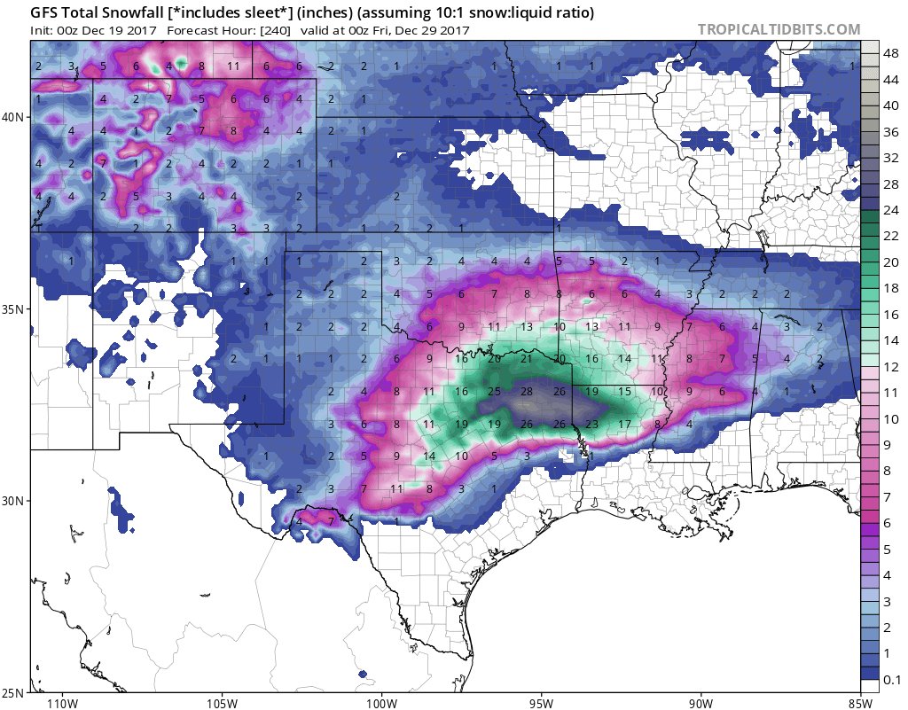
almost 30 inches of snow in spots on the clown maps
but sadly most is ice...
this will never verify anyway but if it does yall can quote me in March when the power comes back
but sadly most is ice...
this will never verify anyway but if it does yall can quote me in March when the power comes back
Last edited by Brent on Mon Dec 18, 2017 11:48 pm, edited 1 time in total.
1 likes
#neversummer
-
stormlover2013
Re: Texas Winter 2017-2018
Lol the models have been horrible since last week and prolongs everything!!! Can’t trust a model 3 days out right now
0 likes

Re: Texas Winter 2017-2018
Brent wrote:almost 30 inches of snow in spots on the clown maps
but sadly most is ice...
this will never verify anyway but if it does yall can quote me in March when the power comes back
 The things i would do for 30 inches of snow here....
1 likes


Re: Texas Winter 2017-2018
orangeblood wrote:1070 HP on Canadian and 1060 HP on GFS for same time frame next week. Also, anyone notice Canadian trying to go negative tilt on Friday night with Rain changing to snow ?
GFS and others have dumped the major storm in the midwest. Canadian might be trying to sniff something out? Friday is getting closer so lets see if its a trend to bring things back in close range after shifting a thousand miles north, its going a thousand miles back south
2 likes
The above post and any post by Ntxw is NOT an official forecast and should not be used as such. It is just the opinion of the poster and may or may not be backed by sound meteorological data. It is NOT endorsed by any professional institution including Storm2k. For official information, please refer to NWS products.
Help support Storm2K!
-
Yukon Cornelius
- S2K Supporter
- Posts: 1836
- Age: 42
- Joined: Thu Dec 20, 2012 9:23 pm
- Location: Dean, TX/Westcliffe, CO
Re: Texas Winter 2017-2018
Ntxw wrote:Yukon Cornelius wrote:Is the sudden warm up on Christmas or after Christmas a model fluke or are we starting to come into the time frame where what’s actually going to happen is starting to show?
Here is the past 10 runs for Christmas afternoon. I guess you can say this is the latest run, sure. Is it the right run? Well If you choose to believe it then yes!
http://i67.tinypic.com/24e5i8h.gif
Pretty much all over the place. I got to thinking what WxMan57 said and with some of the models predicting the extreme cold, where is it actually coming from?
0 likes
#neversummer
-
Ralph's Weather
- S2K Supporter
- Posts: 3371
- Age: 38
- Joined: Fri Dec 13, 2013 11:55 am
- Location: Lindale, TX
- Contact:
Re: Texas Winter 2017-2018
Ntxw wrote:orangeblood wrote:1070 HP on Canadian and 1060 HP on GFS for same time frame next week. Also, anyone notice Canadian trying to go negative tilt on Friday night with Rain changing to snow ?
GFS and others have dumped the major storm in the midwest. Canadian might be trying to sniff something out? Friday is getting closer so lets see if its a trend to bring things back in close rangem after shifting a thousand miles north, its going a thousand miles back south
It would be typical. Get the idea 10 days out keep it for a couple days then lose it and bring it back reluctantly in the short term.
0 likes
Follow on Facebook at Ralph's Weather.
-
bubba hotep

- S2K Supporter
- Posts: 6009
- Joined: Wed Dec 28, 2016 1:00 am
- Location: Collin County Texas
Re: Texas Winter 2017-2018
TeamPlayersBlue wrote:Pro Mets, saw the MJO forecast and it's now expected to move back into its non-existent state. Is this the reason for the trough not digging as deep into the southern plains? Will it not digging as far, this leaves the SE ridge able to flex its muscles.
Any thoughts?
Not a pro, but I figured that I would take a stab at this since no one else answered. There really is no simple answer and maybe Ryan Allen will chime in, since this current MJO pulse has generated some tropical cyclones in the WPAC. Just like anything else, there are examples of MJO phases not resulting in the expected N. American temperature regime. There are examples of Phase 8 not resulting in widespread cold across the US. It is looking more and more like we will see a rotation through 8/1, even though the RMM plots appear to be only somewhat interested in that, it is possible that the la nina background state is muddling the picture. There is a good bit of research out there that points to Phase 8 during a la nina being a truly cold phase and that looks to be locking in here. But back to your question, there really isn't an easy way to connect the dots but we do know that the outflow from the cyclones in the WPAC, that appear to be a result of the MJO, is impacting the Pacific jet. The Pacific jet works as a wave guide and the tropical convection can also amplify the Rossby wave train. Then we can get lower heights at the jet exit region. This is the result of wave breaking and then things get really chaotic as it seems like each model run handles the downstream response of the wave breaking differently. In fact, in the 00z GFS tonight (it has also been showing up in the Euro) we can track the disturbance that sets of the winter storm across Texas from the wave break near Hawaii all the way to the South West.

1 likes
Winter time post are almost exclusively focused on the DFW area.
-
bubba hotep
- S2K Supporter
- Posts: 6009
- Joined: Wed Dec 28, 2016 1:00 am
- Location: Collin County Texas
Re: Texas Winter 2017-2018
Awww Yea!
4 likes
Winter time post are almost exclusively focused on the DFW area.
Re: Texas Winter 2017-2018
Yukon Cornelius wrote:Ntxw wrote:Yukon Cornelius wrote:Is the sudden warm up on Christmas or after Christmas a model fluke or are we starting to come into the time frame where what’s actually going to happen is starting to show?
Here is the past 10 runs for Christmas afternoon. I guess you can say this is the latest run, sure. Is it the right run? Well If you choose to believe it then yes!
http://i67.tinypic.com/24e5i8h.gif
Pretty much all over the place. I got to thinking what WxMan57 said and with some of the models predicting the extreme cold, where is it actually coming from?
Cold air can build as high pressure builds in. It's dark up there this time of year. Cold air isn't just made in western Canada. Cold air loading pattern is dependent, most of the time, by the EPO
2 likes
The above post and any post by Ntxw is NOT an official forecast and should not be used as such. It is just the opinion of the poster and may or may not be backed by sound meteorological data. It is NOT endorsed by any professional institution including Storm2k. For official information, please refer to NWS products.
Help support Storm2K!
Help support Storm2K!
-
Yukon Cornelius
- S2K Supporter
- Posts: 1836
- Age: 42
- Joined: Thu Dec 20, 2012 9:23 pm
- Location: Dean, TX/Westcliffe, CO
Re: Texas Winter 2017-2018
Ntxw wrote:Yukon Cornelius wrote:Ntxw wrote:
Here is the past 10 runs for Christmas afternoon. I guess you can say this is the latest run, sure. Is it the right run? Well If you choose to believe it then yes!
http://i67.tinypic.com/24e5i8h.gif
Pretty much all over the place. I got to thinking what WxMan57 said and with some of the models predicting the extreme cold, where is it actually coming from?
Cold air can build as high pressure builds in. It's dark up there this time of year. Cold air isn't just made in western Canada. Cold air loading pattern is dependent, most of the time, by the EPO
Interesting. Thanks a lot.
0 likes
#neversummer
-
stormlover2013
Re: Texas Winter 2017-2018
Wxman is who I’m with, no reason to get excited and jump the gun these models have been horrendous
Last edited by stormlover2013 on Tue Dec 19, 2017 12:13 am, edited 1 time in total.
0 likes
Re: Texas Winter 2017-2018
Yukon Cornelius wrote:Interesting. Thanks a lot.
Wxman57 knows about this stuff more than anybody here. But we hashed this out a little bit last winter. Just before the Jan blast (coldest raw temp since 2011). Had a whole discussion about lack of very cold air in NW Canada. Cold came anyway a week later when the -EPO hit almost -4SD. He isn't wrong about having cold up there is a good bet for cold here, but it's not detrimental.
viewtopic.php?f=22&t=117967&start=2560
1 likes
The above post and any post by Ntxw is NOT an official forecast and should not be used as such. It is just the opinion of the poster and may or may not be backed by sound meteorological data. It is NOT endorsed by any professional institution including Storm2k. For official information, please refer to NWS products.
Help support Storm2K!
Help support Storm2K!
-
Yukon Cornelius
- S2K Supporter
- Posts: 1836
- Age: 42
- Joined: Thu Dec 20, 2012 9:23 pm
- Location: Dean, TX/Westcliffe, CO
Re: Texas Winter 2017-2018
Ntxw wrote:Yukon Cornelius wrote:Interesting. Thanks a lot.
Wxman57 knows about this stuff more than anybody here. But we hashed this out a little bit last winter. Just before the Jan blast (coldest raw temp since 2011). Had a whole discussion about lack of very cold air in NW Canada. Cold came anyway a week later when the -EPO hit almost -4SD. He isn't wrong about having cold up there is a good bet for cold here, but it's not detrimental.
viewtopic.php?f=22&t=117967&start=2560
Ok, I remember this now. For someone such as myself that is merely a weather enthusiast, it’s a ton to take in and try and figure out. Every year I’m here I walk away after winter with more and more knowledge. I appreciate it.
3 likes
#neversummer


Re: Texas Winter 2017-2018
Im all for a good winter storm 
But when you start talking about 1983..id rather it be 60 outside
Im old enough(ugh lol) to remember that dec...
It may sound fun but when you wake up at 4am in the morning and step down into a foot of water in the sunken living room it becomes not to fun...cars didnt want to run..antifreeze wasnt as good back then.. water mains broke some didnt have water for weeks afterwards..
0 likes
just a guess.......take everything i say with a grain of salt.......check your local NWS for forecast information
Who is online
Users browsing this forum: Brent and 86 guests