Texas Winter 2017-2018

Winter Weather Discussion

Moderator: S2k Moderators

Forum rules

The posts in this forum are NOT official forecast and should not be used as such. They are just the opinion of the poster and may or may not be backed by sound meteorological data. They are NOT endorsed by any professional institution or STORM2K.

Help Support Storm2K
Message
Author
User avatar
Ntxw
Storm2k Moderator
Storm2k Moderator
Posts: 22796
Joined: Wed Oct 21, 2009 6:34 pm
Location: DFW, Texas

Re: Texas Winter 2017-2018

#3601 Postby Ntxw » Tue Dec 26, 2017 11:33 pm

OKMet83 wrote:If you compare the 00Z GFS run to past several runs for New Years Eve/Day Precip keeps getting pushed further west into the heart of North-Central Tx and portions of Oklahoma... IF this trend continues and I want to stress IF we could be looking at a surprise Ice /Winter Storm... I know Not a lot of talk about a storm with this but I see some stuff coming together that could work in it's favor but as we know still many days to work the fine details out.... Plenty of Tropical Moisture feeding into our Northern Pacific Storm system that will come down right into OK/N .TX.... If something pans out with this it would be no bueno especially with temperatures being below freezing for multiple days across the region. All I can tell you right now is Stay tuned! ;)


It's been trending better. Even the Euro was close. That NW jet streak if it digs more into the Rockies we'd have a mess and then very cold temperatures. It's key in both allowing cold to spill and whipping up statewide winter precip
1 likes   
The above post and any post by Ntxw is NOT an official forecast and should not be used as such. It is just the opinion of the poster and may or may not be backed by sound meteorological data. It is NOT endorsed by any professional institution including Storm2k. For official information, please refer to NWS products.

  Help support Storm2K!
Help Support Storm2K

User avatar
South Texas Storms
Professional-Met
Professional-Met
Posts: 4236
Joined: Thu Jun 24, 2010 12:28 am
Location: Houston, TX

Re: Texas Winter 2017-2018

#3602 Postby South Texas Storms » Tue Dec 26, 2017 11:35 pm

Ntxw wrote:
South Texas Storms wrote:
Ntxw wrote:0z GFS is more ridging into Western Canada than previous runs after cold wave


Think all of that energy out in the Pacific will eventually win out and break down the West Coast ridge. Euro and most of the ensembles are indicating this will happen in the extended as well.

This will likely bring us a wet pattern (I hope it verifies).


I hope so too. But the PNA has been relentless the past month and the forecast continues to be positive. I'm not sure that will be as easy to break down. Every time the models try, it springs right back up. Especially with the -SOI still hanging around is more Nino +PNA

SOI was -11 today with the unbroken chain


Yeah I agree. Just hard to not believe since most of the long range guidance is indicating it will happen. Even the Euro Weeklies have been showing this for the past few runs.
0 likes   

User avatar
Ntxw
Storm2k Moderator
Storm2k Moderator
Posts: 22796
Joined: Wed Oct 21, 2009 6:34 pm
Location: DFW, Texas

Re: Texas Winter 2017-2018

#3603 Postby Ntxw » Tue Dec 26, 2017 11:36 pm

Both CMC and GFS (not as prolific as the crazy uncle) sends 1040s HP southward middle to late week after NYE as the PNA rise. Might be another reinforcing shot of cold air
1 likes   
The above post and any post by Ntxw is NOT an official forecast and should not be used as such. It is just the opinion of the poster and may or may not be backed by sound meteorological data. It is NOT endorsed by any professional institution including Storm2k. For official information, please refer to NWS products.


  Help support Storm2K!

Help Support Storm2K


User avatar
Rgv20
S2K Supporter
S2K Supporter
Posts: 2466
Age: 39
Joined: Wed Jan 05, 2011 5:42 pm
Location: Edinburg/McAllen Tx

Re: Texas Winter 2017-2018

#3604 Postby Rgv20 » Tue Dec 26, 2017 11:37 pm

WOW crazy uncle CMC trying to kill of the RGV....has temperatures below freezing from mid day Monday to Friday morning...
0 likes   
The following post is NOT an official forecast and should not be used as such. It is just the opinion of the poster and may or may not be backed by sound meteorological data. It is NOT endorsed by any professional institution including storm2k.org For Official Information please refer to the NHC and NWS products.

User avatar
Ntxw
Storm2k Moderator
Storm2k Moderator
Posts: 22796
Joined: Wed Oct 21, 2009 6:34 pm
Location: DFW, Texas

Re: Texas Winter 2017-2018

#3605 Postby Ntxw » Tue Dec 26, 2017 11:42 pm

Big poleward Aleutian trough beyond 200 hours of GFS, might be another Alaskan ridge run long range. But you're starting to really go way out there. Same series of events we just went through
0 likes   
The above post and any post by Ntxw is NOT an official forecast and should not be used as such. It is just the opinion of the poster and may or may not be backed by sound meteorological data. It is NOT endorsed by any professional institution including Storm2k. For official information, please refer to NWS products.


  Help support Storm2K!

Help Support Storm2K


User avatar
Cpv17
Category 5
Category 5
Posts: 5027
Joined: Wed Dec 07, 2016 2:24 pm
Location: Wharton/El Campo, TX

Re: Texas Winter 2017-2018

#3606 Postby Cpv17 » Tue Dec 26, 2017 11:43 pm

Rgv20 wrote:WOW crazy uncle CMC trying to kill of the RGV....has temperatures below freezing from mid day Monday to Friday morning...

It’s fun and comical to look at :lol:
0 likes   

User avatar
South Texas Storms
Professional-Met
Professional-Met
Posts: 4236
Joined: Thu Jun 24, 2010 12:28 am
Location: Houston, TX

Re: Texas Winter 2017-2018

#3607 Postby South Texas Storms » Tue Dec 26, 2017 11:44 pm

0z UKMET looks cold too. Not sure how much precip it's showing with the cold air though. Should know that in about 45 mins when the maps update here: http://wx.graphics/models/ukmet/ukmet.php
0 likes   

User avatar
Ntxw
Storm2k Moderator
Storm2k Moderator
Posts: 22796
Joined: Wed Oct 21, 2009 6:34 pm
Location: DFW, Texas

Re: Texas Winter 2017-2018

#3608 Postby Ntxw » Tue Dec 26, 2017 11:49 pm

South Texas Storms wrote:0z UKMET looks cold too. Not sure how much precip it's showing with the cold air though. Should know that in about 45 mins when the maps update here: http://wx.graphics/models/ukmet/ukmet.php


I don't think the 0z Ukmet is out yet. Earlier today the 12z run left the Euro's camp and sided with the others
0 likes   
The above post and any post by Ntxw is NOT an official forecast and should not be used as such. It is just the opinion of the poster and may or may not be backed by sound meteorological data. It is NOT endorsed by any professional institution including Storm2k. For official information, please refer to NWS products.


  Help support Storm2K!

Help Support Storm2K


User avatar
Ntxw
Storm2k Moderator
Storm2k Moderator
Posts: 22796
Joined: Wed Oct 21, 2009 6:34 pm
Location: DFW, Texas

Re: Texas Winter 2017-2018

#3609 Postby Ntxw » Tue Dec 26, 2017 11:52 pm

I take that back. Here is the 0z Ukmet. It's trended with a more broad ridge and is getting closer to the GFS and other's trajectory down the Great Plains.

Image
0 likes   
The above post and any post by Ntxw is NOT an official forecast and should not be used as such. It is just the opinion of the poster and may or may not be backed by sound meteorological data. It is NOT endorsed by any professional institution including Storm2k. For official information, please refer to NWS products.


  Help support Storm2K!

Help Support Storm2K


User avatar
bubba hotep
S2K Supporter
S2K Supporter
Posts: 5837
Joined: Wed Dec 28, 2016 1:00 am
Location: Collin County Texas

Re: Texas Winter 2017-2018

#3610 Postby bubba hotep » Tue Dec 26, 2017 11:53 pm

South Texas Storms wrote:
bubba hotep wrote:Really starting to diverge again at 96h.


Yeah but the GFS did trend closer to the Euro tonight regarding that energy currently near Hawaii. Is it the start of a cave towards the Euro?


Complex setup to get to this point, but here moving forward - GFS is faster with the northern wave and slower with the southern wave. This creates an opening, that is still present on the 00z GFS, that allows ridging to surge north towards Alaska. At this point, 12z Friday, 27 00z GFS and 26 12z Euro aren't that far off. It is everything that happens after this point that causes the drastic change. So, we close to a split hair type setup with possible small changes having pretty big impacts on the sensible weather across TX next week.

Image
2 likes   
Winter time post are almost exclusively focused on the DFW area.

User avatar
South Texas Storms
Professional-Met
Professional-Met
Posts: 4236
Joined: Thu Jun 24, 2010 12:28 am
Location: Houston, TX

Re: Texas Winter 2017-2018

#3611 Postby South Texas Storms » Tue Dec 26, 2017 11:54 pm

0z Canadian also has some light snow across central and southeast TX at the end of the run.
0 likes   

orangeblood
S2K Supporter
S2K Supporter
Posts: 3714
Joined: Tue Dec 15, 2009 6:14 pm
Location: Fort Worth, TX

Re: Texas Winter 2017-2018

#3612 Postby orangeblood » Tue Dec 26, 2017 11:59 pm

South Texas Storms wrote:
Ntxw wrote:0z GFS is more ridging into Western Canada than previous runs after cold wave


Think all of that energy out in the Pacific will eventually win out and break down the West Coast ridge. Euro and most of the ensembles are indicating this will happen in the extended as well.

This will likely bring us a wet pattern (I hope it verifies).


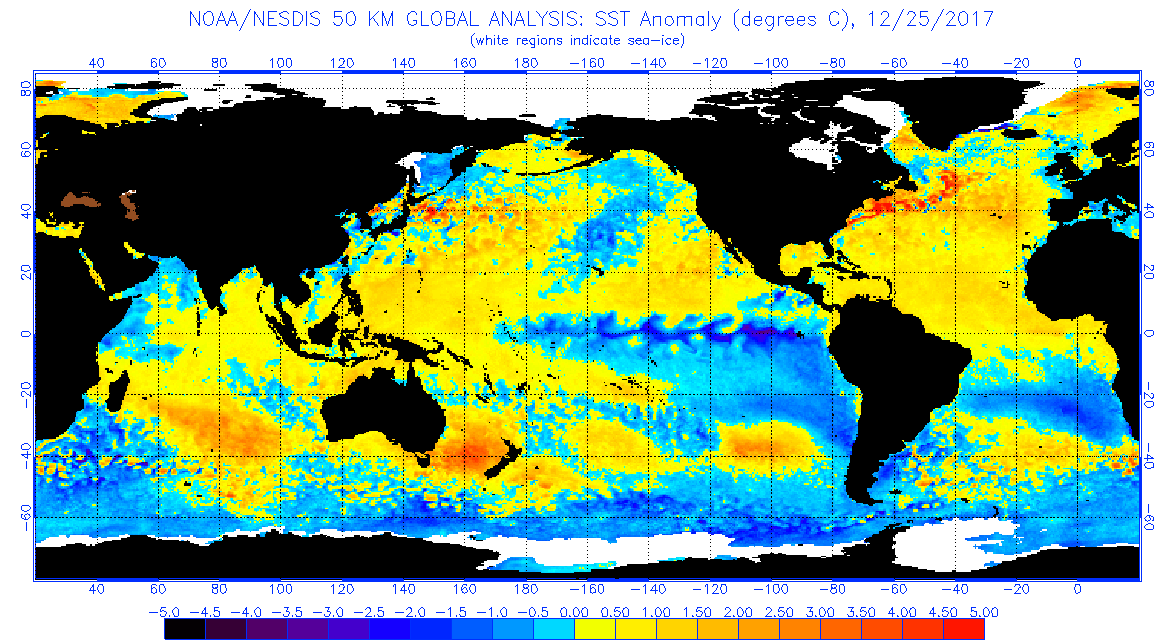
The warm anomalies along the West Coast might have something to do with the resistance...it will be tough to break through in any sort of extended term unless it begins to erode

Also, notice the cold anomalies north of Hawaii...exactly the area a lot of this Pacific energy drops down into

Image
0 likes   

User avatar
Ntxw
Storm2k Moderator
Storm2k Moderator
Posts: 22796
Joined: Wed Oct 21, 2009 6:34 pm
Location: DFW, Texas

Re: Texas Winter 2017-2018

#3613 Postby Ntxw » Wed Dec 27, 2017 12:00 am

50s and 60s return to the Great State on 384hr GFS. It will nail it right? :wink:

Image
2 likes   
The above post and any post by Ntxw is NOT an official forecast and should not be used as such. It is just the opinion of the poster and may or may not be backed by sound meteorological data. It is NOT endorsed by any professional institution including Storm2k. For official information, please refer to NWS products.


  Help support Storm2K!

Help Support Storm2K


User avatar
Ntxw
Storm2k Moderator
Storm2k Moderator
Posts: 22796
Joined: Wed Oct 21, 2009 6:34 pm
Location: DFW, Texas

Re: Texas Winter 2017-2018

#3614 Postby Ntxw » Wed Dec 27, 2017 12:01 am

orangeblood wrote:
South Texas Storms wrote:
Ntxw wrote:0z GFS is more ridging into Western Canada than previous runs after cold wave


Think all of that energy out in the Pacific will eventually win out and break down the West Coast ridge. Euro and most of the ensembles are indicating this will happen in the extended as well.

This will likely bring us a wet pattern (I hope it verifies).


The warm anomalies along the West Coast might have something to do with the resistance...it will be tough to break through in any sort of extended term unless it begins to erode

Also, notice the cold anomalies north of Hawaii...exactly the area a lot of this Pacific energy drops down into

http://www.ospo.noaa.gov/data/sst/anoma ... 5.2017.gif


Yeah it's really tough to break. Wavelengths are long now and SSTs like that established is hard to overcome. Especially when -SOI is indicating the tropical forcing is in areas with constructive interference (bubba mentioned this earlier).

Poleward cyclogenesis from the Sea of Okhotsk to the Aleutians -> Bering I think will continue. That favors ridging in the eastern N Pacific
2 likes   
The above post and any post by Ntxw is NOT an official forecast and should not be used as such. It is just the opinion of the poster and may or may not be backed by sound meteorological data. It is NOT endorsed by any professional institution including Storm2k. For official information, please refer to NWS products.


  Help support Storm2K!

Help Support Storm2K


User avatar
South Texas Storms
Professional-Met
Professional-Met
Posts: 4236
Joined: Thu Jun 24, 2010 12:28 am
Location: Houston, TX

Re: Texas Winter 2017-2018

#3615 Postby South Texas Storms » Wed Dec 27, 2017 12:06 am

:uarrow:
Good points guys. Like I mentioned last night, it's key that we keep getting regular precip to keep our soils wet. If we see an extended dry period this winter and spring, the upcoming summer could be brutal. We want to avoid that at all costs.

It's going to be a real shame if we don't get any snow from this upcoming cold pattern. We don't see those kind of cold temps very often. Let's take advantage of it.
5 likes   

User avatar
bubba hotep
S2K Supporter
S2K Supporter
Posts: 5837
Joined: Wed Dec 28, 2016 1:00 am
Location: Collin County Texas

Re: Texas Winter 2017-2018

#3616 Postby bubba hotep » Wed Dec 27, 2017 12:09 am

orangeblood wrote:
South Texas Storms wrote:
Ntxw wrote:0z GFS is more ridging into Western Canada than previous runs after cold wave


Think all of that energy out in the Pacific will eventually win out and break down the West Coast ridge. Euro and most of the ensembles are indicating this will happen in the extended as well.

This will likely bring us a wet pattern (I hope it verifies).


The warm anomalies along the West Coast might have something to do with the resistance...it will be tough to break through in any sort of extended term unless it begins to erode

Also, notice the cold anomalies north of Hawaii...exactly the area a lot of this Pacific energy drops down into

Image


Matches up pretty well with the patter so far for December

Image
1 likes   
Winter time post are almost exclusively focused on the DFW area.

User avatar
Ntxw
Storm2k Moderator
Storm2k Moderator
Posts: 22796
Joined: Wed Oct 21, 2009 6:34 pm
Location: DFW, Texas

Re: Texas Winter 2017-2018

#3617 Postby Ntxw » Wed Dec 27, 2017 12:10 am

South Texas Storms wrote::uarrow:
Good points guys. Like I mentioned last night, it's key that we keep getting regular precip to keep our soils wet. If we see an extended dry period this winter and spring, the upcoming summer could be brutal. We want to avoid that at all costs.


I've partially already given in for a dry/hot summer :cry:. I hope I am totally wrong on this. My hope is we get an El Nino to try and go late spring. Subsurface once again is primed with a lot of warm waters down-welled in the western basin. A series of WWB's would be mighty beneficial come February.
1 likes   
The above post and any post by Ntxw is NOT an official forecast and should not be used as such. It is just the opinion of the poster and may or may not be backed by sound meteorological data. It is NOT endorsed by any professional institution including Storm2k. For official information, please refer to NWS products.


  Help support Storm2K!

Help Support Storm2K


User avatar
South Texas Storms
Professional-Met
Professional-Met
Posts: 4236
Joined: Thu Jun 24, 2010 12:28 am
Location: Houston, TX

Re: Texas Winter 2017-2018

#3618 Postby South Texas Storms » Wed Dec 27, 2017 12:14 am

Ntxw wrote:
South Texas Storms wrote::uarrow:
Good points guys. Like I mentioned last night, it's key that we keep getting regular precip to keep our soils wet. If we see an extended dry period this winter and spring, the upcoming summer could be brutal. We want to avoid that at all costs.


I've partially already given in for a dry/hot summer :cry:. I hope I am totally wrong on this. My hope is we get an El Nino to try and go late spring. Subsurface once again is primed with a lot of warm waters down-welled in the western basin. A series of WWB's would be mighty beneficial come February.


Don't give up hope yet! That's why I keep mentioning the soil moisture. It's a huge factor (drought begets drought). Winter and spring precip is critical to avoid a horrific summer.

And yeah, a developing El Nino next year sure would be awesome.
1 likes   

User avatar
Cpv17
Category 5
Category 5
Posts: 5027
Joined: Wed Dec 07, 2016 2:24 pm
Location: Wharton/El Campo, TX

Re: Texas Winter 2017-2018

#3619 Postby Cpv17 » Wed Dec 27, 2017 12:17 am

South Texas Storms wrote::uarrow:
Good points guys. Like I mentioned last night, it's key that we keep getting regular precip to keep our soils wet. If we see an extended dry period this winter and spring, the upcoming summer could be brutal. We want to avoid that at all costs.

It's going to be a real shame if we don't get any snow from this upcoming cold pattern. We don't see those kind of cold temps very often. Let's take advantage of it.


Exactly! That’s pretty much all I want is a few inches of snow. And the icing on the cake would be for it stay below freezing for a day or two so it doesn’t melt away like it usually does around here.
3 likes   

User avatar
SoupBone
Category 5
Category 5
Posts: 3111
Joined: Tue Sep 20, 2005 5:24 pm

Re: Texas Winter 2017-2018

#3620 Postby SoupBone » Wed Dec 27, 2017 12:22 am

Sooooo Weather.com is showing rain and snow for Monday. What the heck have I been missing? I guess too much egg nog will do that. What's going on?!
2 likes   
Personal Forecast Disclaimer:
The posts in this forum are NOT official forecast and should not be used as such. They are just the opinion of the poster and may or may not be backed by sound meteorological data. They are NOT endorsed by any professional institution or storm2k.org. For official information, please refer to the NHC and NWS products.


Return to “Winter Weather”

Who is online

Users browsing this forum: No registered users and 29 guests