


Moderator: S2k Moderators
 The posts in this forum are NOT official forecast and should not be used as such. They are just the opinion of the poster and may or may not be backed by sound meteorological data. They are NOT endorsed by any professional institution or STORM2K.

orangeblood wrote:12Z Euro continues the promising trend of the potential for the first MAJOR winter storm for the southern plains Jan. 12-13th...looking at the 500mb pattern and the origin of the air accompanying the Arctic HP headed into Northern US, this system should trend further south on the models with time - The Euro shows the Arctic HP getting scoured out as the Pacific system moves across but we all know that rarely happens. Something to definitely follow over the coming week
https://www.tropicaltidbits.com/analysi ... nhem_9.png


wxman22 wrote:18z HRRR is still looking interesting...
http://models.weatherbell.com/hrrr/2018 ... ton_10.png
http://models.weatherbell.com/hrrr/2018 ... ton_11.png
stormlover2013 wrote:South Texas storms u think it will pan out ?


Cpv17 wrote:This sucks!!
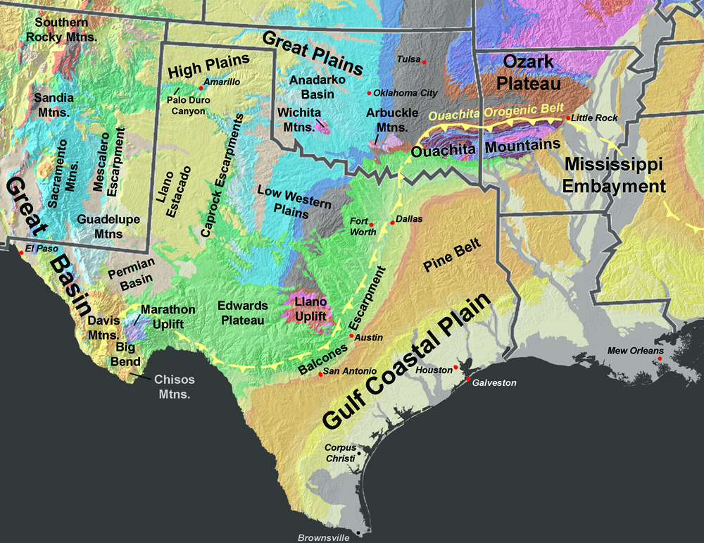
From Joe B: downsloping off Ozarks results in "Ozark Shadow) in east Texas temp anomalies as cold flows freely west and east of the shadow Same thing seen in SC and GA from Appalachians
Ralph's Weather wrote:Cpv17 wrote:This sucks!!
From Joe B: downsloping off Ozarks results in "Ozark Shadow) in east Texas temp anomalies as cold flows freely west and east of the shadow Same thing seen in SC and GA from Appalachians
This is very noticable shortly after a shallow cold air mass moves in. Ibelieve it really is the Ouachita Mountains though. They are I believe the only E/W oriented range in the US stretching from SE OK to SW AR. Models do not always seem to account for this well. They saved us on Sunday from having freezing drizzle on Sunday as temps held in the 37 range vs 32 range until precip moved out.
wxman57 wrote:HRRR has up to 2" of snow NE of Houston tonight. 1/2" to 1" across Houston:
http://wxman57.com/images/snow.JPG
Cpv17 wrote:Ralph's Weather wrote:Cpv17 wrote:This sucks!!
From Joe B: downsloping off Ozarks results in "Ozark Shadow) in east Texas temp anomalies as cold flows freely west and east of the shadow Same thing seen in SC and GA from Appalachians
This is very noticable shortly after a shallow cold air mass moves in. Ibelieve it really is the Ouachita Mountains though. They are I believe the only E/W oriented range in the US stretching from SE OK to SW AR. Models do not always seem to account for this well. They saved us on Sunday from having freezing drizzle on Sunday as temps held in the 37 range vs 32 range until precip moved out.
It’s interesting. I’ve never heard anyone talk about it on here before.
orangeblood wrote:Cpv17 wrote:Ralph's Weather wrote:This is very noticable shortly after a shallow cold air mass moves in. Ibelieve it really is the Ouachita Mountains though. They are I believe the only E/W oriented range in the US stretching from SE OK to SW AR. Models do not always seem to account for this well. They saved us on Sunday from having freezing drizzle on Sunday as temps held in the 37 range vs 32 range until precip moved out.
It’s interesting. I’ve never heard anyone talk about it on here before.
Yeah, we've discussed this several times over the years...fascinating to watch unfold and it really is pronounced once the Arctic High's move off to the east and winds become more Northeasterly. I've noticed it even has an effect on temps as far west as Dallas
http://gotbooks.miracosta.edu/geology/images2/texas.jpg
TexasF6 wrote:Guys, I am seeing moisture returns in West Travis County? (TexasMesoNet radar) There is a fine mist coming down? Humidity is rising (or trying to) from west to east in Travis county obersvations. Thoughts?


Quixotic wrote:orangeblood, it's a lock as I will be travelling home one of those days.
Users browsing this forum: No registered users and 87 guests


