ATL: ALBERTO - Post-Tropical

Moderator: S2k Moderators

Message
Author
User avatar
Evil Jeremy
S2K Supporter
S2K Supporter
Posts: 5463
Age: 32
Joined: Mon Apr 10, 2006 2:10 pm
Location: Los Angeles, CA

Re: ATL: ALBERTO - Sub-Tropical Storm

#1601 Postby Evil Jeremy » Sat May 26, 2018 1:02 pm

MGC wrote:With the new center forming, I think the threat to the Florida Peninsula has increased. Looking more tropical with the convection located near the center. Appears to be becoming better organized. Interesting what next recon mission reveals......MGC


How does the reformation incidate a larger threat to the Florida peninsula? I figured since the reformatIon was a little bit west, it would perhaps add just a little distance to the peninsula, not end up bringing it closer. Or are you referring to stronger effects in the outer bands?
0 likes   
Frances 04 / Jeanne 04 / Katrina 05 / Wilma 05 / Fay 08 / Debby 12 / Andrea 13 / Colin 16 / Hermine 16 / Matthew 16 / Irma 17

User avatar
Ivanhater
Storm2k Moderator
Storm2k Moderator
Posts: 11162
Age: 38
Joined: Fri Jul 01, 2005 8:25 am
Location: Pensacola

Re: ATL: ALBERTO - Models

#1602 Postby Ivanhater » Sat May 26, 2018 1:02 pm

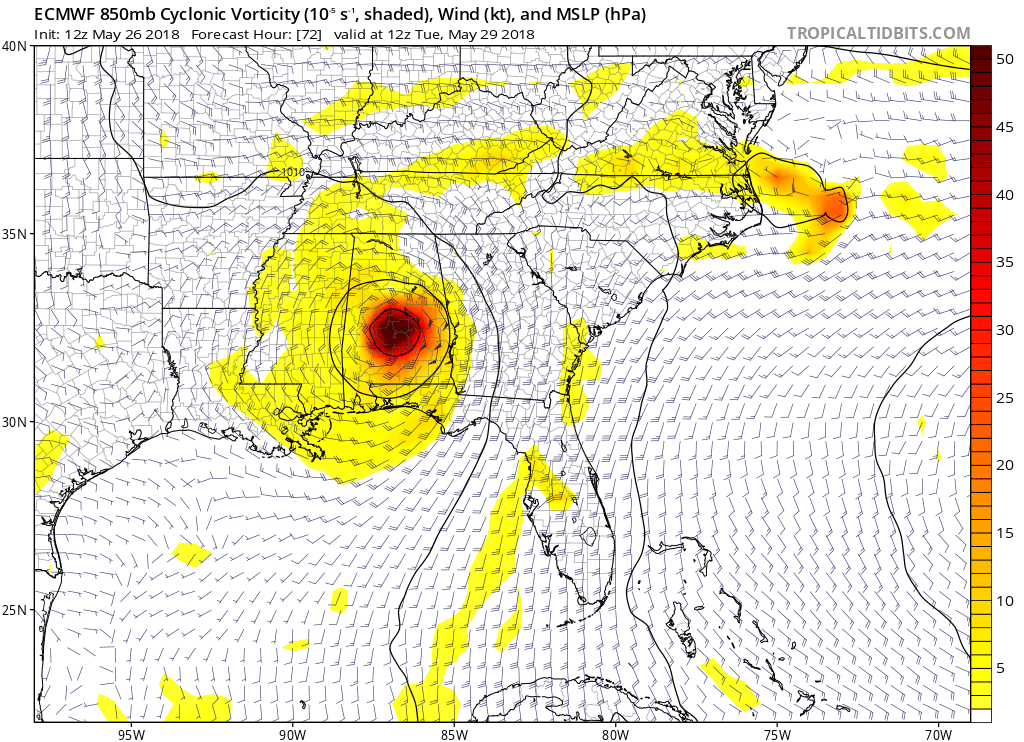
And euro shows strengthening before landfall as well
0 likes   
Michael

User avatar
fwbbreeze
S2K Supporter
S2K Supporter
Posts: 896
Joined: Sun Mar 21, 2004 10:09 pm
Location: Fort Walton Beach, FL

Re: ATL: ALBERTO - Models

#1603 Postby fwbbreeze » Sat May 26, 2018 1:03 pm

Bit of an "Erin"esque approach there. Not referencing the full track or intensity just the direction at landfall.
0 likes   

User avatar
tarheelprogrammer
S2K Supporter
S2K Supporter
Posts: 1793
Joined: Mon Mar 28, 2016 9:25 pm
Location: Raleigh, NC area (Garner, NC)

Re: ATL: ALBERTO - Models

#1604 Postby tarheelprogrammer » Sat May 26, 2018 1:04 pm

ECMWF being weaker is a good thing. Trends are as positive as they can be. Regardless, looks like models showing a good amount of rain. Hopefully, shear does not let up.
0 likes   
My posts are not official forecasts. They are just my opinion and may or may not be backed by sound meteorological data. They are NOT endorsed by any professional institution or storm2k.org. For official information, please refer to the NHC and NWS products.

User avatar
FLpanhandle91
Category 5
Category 5
Posts: 1033
Age: 34
Joined: Mon Sep 13, 2010 3:50 pm
Location: Fort Walton Beach, FL

Re: ATL: ALBERTO - Models

#1605 Postby FLpanhandle91 » Sat May 26, 2018 1:05 pm

fwbbreeze wrote:Bit of an "Erin"esque approach there. Not referencing the full track or intensity just the direction at landfall.

Thinking the exact same thing. Very much like erin with the ESE to WNW approach.
0 likes   

TheStormExpert

Re: ATL: ALBERTO - Models

#1606 Postby TheStormExpert » Sat May 26, 2018 1:07 pm

First off the 12z Euro initialized Alberto as a 1005mb low when as of 2pm it is already down to 999mb.
0 likes   

User avatar
gatorcane
S2K Supporter
S2K Supporter
Posts: 23691
Age: 47
Joined: Sun Mar 13, 2005 3:54 pm
Location: Boca Raton, FL

Re: ATL: ALBERTO - Models

#1607 Postby gatorcane » Sat May 26, 2018 1:08 pm

Image
0 likes   

User avatar
Hammy
Category 5
Category 5
Posts: 5849
Age: 42
Joined: Fri May 25, 2012 5:25 pm
Contact:

Re: ATL: ALBERTO - Models

#1608 Postby Hammy » Sat May 26, 2018 1:08 pm

I think it's possible we could disregard this set of models on the intensity forecasts as Alberto was much more disorganized just a few hours ago when the data came out.
1 likes   
The above post is not official and should not be used as such. It is the opinion of the poster and may or may not be backed by sound meteorological data. It is not endorsed by any professional institution or storm2k.org. For official information, please refer to the NHC and NWS products.

tolakram
Admin
Admin
Posts: 20012
Age: 62
Joined: Sun Aug 27, 2006 8:23 pm
Location: Florence, KY (name is Mark)

Re: ATL: ALBERTO - Models

#1609 Postby tolakram » Sat May 26, 2018 1:09 pm

This is from Weathermodels.com. I could not find anything on image sharing but will only post this part of the frame to show landfall. Max winds 39.3 knots.

Image
1 likes   
M a r k
- - - - -
Join us in chat: Storm2K Chatroom Invite. Android and IOS apps also available.

The posts in this forum are NOT official forecasts and should not be used as such. Posts are NOT endorsed by any professional institution or STORM2K.org. For official information and forecasts, please refer to NHC and NWS products.

User avatar
Ivanhater
Storm2k Moderator
Storm2k Moderator
Posts: 11162
Age: 38
Joined: Fri Jul 01, 2005 8:25 am
Location: Pensacola

Re: ATL: ALBERTO - Models

#1610 Postby Ivanhater » Sat May 26, 2018 1:09 pm

Still packing a punch inland
0 likes   
Michael

tolakram
Admin
Admin
Posts: 20012
Age: 62
Joined: Sun Aug 27, 2006 8:23 pm
Location: Florence, KY (name is Mark)

Re: ATL: ALBERTO - Models

#1611 Postby tolakram » Sat May 26, 2018 1:13 pm

Here's the free version from weather.us. With the 3 hour intervals look at this approach.

Image
0 likes   
M a r k
- - - - -
Join us in chat: Storm2K Chatroom Invite. Android and IOS apps also available.

The posts in this forum are NOT official forecasts and should not be used as such. Posts are NOT endorsed by any professional institution or STORM2K.org. For official information and forecasts, please refer to NHC and NWS products.

User avatar
gatorcane
S2K Supporter
S2K Supporter
Posts: 23691
Age: 47
Joined: Sun Mar 13, 2005 3:54 pm
Location: Boca Raton, FL

Re: ATL: ALBERTO - Models

#1612 Postby gatorcane » Sat May 26, 2018 1:13 pm

I was looking back at the Euro runs and looks like it has shifted like 300-400 miles to the east on its closest approach to Florida from runs just a couple of days ago. The UKMET looks like it is going to nail the track on this storm. Props to that model.
Last edited by gatorcane on Sat May 26, 2018 1:16 pm, edited 1 time in total.
2 likes   

User avatar
Ivanhater
Storm2k Moderator
Storm2k Moderator
Posts: 11162
Age: 38
Joined: Fri Jul 01, 2005 8:25 am
Location: Pensacola

Re: ATL: ALBERTO - Models

#1613 Postby Ivanhater » Sat May 26, 2018 1:16 pm

Great loop! That loop has it wobbling right up to landfall between P'cola and FWB....long couple of days ahead
0 likes   
Michael

slamdaddy
Tropical Storm
Tropical Storm
Posts: 111
Joined: Wed Aug 24, 2016 7:57 am
Location: Gautier, MS

Re: ATL: ALBERTO - Models

#1614 Postby slamdaddy » Sat May 26, 2018 1:16 pm

Not trying to be a chucklehead...but model data is as of the model time. 1200Z run is information accumulated as of that time. so the 1200Z run was as of 7AM CDT or 8AM CDT. not sure if this has any bearing on the center reformation that was discovered around 10AM CDT.
0 likes   

tolakram
Admin
Admin
Posts: 20012
Age: 62
Joined: Sun Aug 27, 2006 8:23 pm
Location: Florence, KY (name is Mark)

Re: ATL: ALBERTO - Models

#1615 Postby tolakram » Sat May 26, 2018 1:17 pm

Here's landfall with wind speeds.

Image
1 likes   
M a r k
- - - - -
Join us in chat: Storm2K Chatroom Invite. Android and IOS apps also available.

The posts in this forum are NOT official forecasts and should not be used as such. Posts are NOT endorsed by any professional institution or STORM2K.org. For official information and forecasts, please refer to NHC and NWS products.

Dean4Storms
S2K Supporter
S2K Supporter
Posts: 6358
Age: 62
Joined: Sun Aug 31, 2003 1:01 pm
Location: Miramar Bch. FL

Re: ATL: ALBERTO - Models

#1616 Postby Dean4Storms » Sat May 26, 2018 1:17 pm

ECM into Navarre with center.....Wind gusts from P'Cola to PCB 60-70mph!
0 likes   

User avatar
MGC
S2K Supporter
S2K Supporter
Posts: 5899
Joined: Sun Mar 23, 2003 9:05 pm
Location: Pass Christian MS, or what is left.

Re: ATL: ALBERTO - Sub-Tropical Storm

#1617 Postby MGC » Sat May 26, 2018 1:17 pm

Evil Jeremy wrote:
MGC wrote:With the new center forming, I think the threat to the Florida Peninsula has increased. Looking more tropical with the convection located near the center. Appears to be becoming better organized. Interesting what next recon mission reveals......MGC


How does the reformation incidate a larger threat to the Florida peninsula? I figured since the reformatIon was a little bit west, it would perhaps add just a little distance to the peninsula, not end up bringing it closer. Or are you referring to stronger effects in the outer bands?


The center of Alberto is further north, less time for the ULL to turn it NW. I am thinking between AL/FL state line and Destin.....MGC
1 likes   

tolakram
Admin
Admin
Posts: 20012
Age: 62
Joined: Sun Aug 27, 2006 8:23 pm
Location: Florence, KY (name is Mark)

Re: ATL: ALBERTO - Models

#1618 Postby tolakram » Sat May 26, 2018 1:18 pm

slamdaddy wrote:Not trying to be a chucklehead...but model data is as of the model time. 1200Z run is information accumulated as of that time. so the 1200Z run was as of 7AM CDT or 8AM CDT. not sure if this has any bearing on the center reformation that was discovered around 10AM CDT.


The euro initialized near the new center location.
0 likes   
M a r k
- - - - -
Join us in chat: Storm2K Chatroom Invite. Android and IOS apps also available.

The posts in this forum are NOT official forecasts and should not be used as such. Posts are NOT endorsed by any professional institution or STORM2K.org. For official information and forecasts, please refer to NHC and NWS products.

User avatar
Ivanhater
Storm2k Moderator
Storm2k Moderator
Posts: 11162
Age: 38
Joined: Fri Jul 01, 2005 8:25 am
Location: Pensacola

Re: ATL: ALBERTO - Models

#1619 Postby Ivanhater » Sat May 26, 2018 1:18 pm

Dean4Storms wrote:ECM into Navarre with center.....Wind gusts from P'Cola to PCB 60-70mph!


:eek: Get the coffee ready Dean!
0 likes   
Michael

crimi481
Category 2
Category 2
Posts: 602
Joined: Thu Sep 09, 2004 4:47 pm

Re: ATL: ALBERTO - Sub-Tropical Storm

#1620 Postby crimi481 » Sat May 26, 2018 1:19 pm

So what effect will all this dry air have on the storm intensification? Looks like being infused in center
http://weather.cod.edu/satrad/exper/?pa ... rbars=data
0 likes   


Return to “2018”

Who is online

Users browsing this forum: No registered users and 2 guests